Headlines
- Odds of tropical development next week are increasing, likely beginning Tuesday or Wednesday.
- There is a growing consensus among modeling that this system has the potential to strengthen a good bit as it comes northward and is likely to accelerate toward the central or eastern Gulf Coast late in the week.
- The odds of a system getting buried in the Bay of Campeche are lessening.
- The odds of an impact to Texas are lessening.
- People on the Gulf Coast between Louisiana and Florida should be following forecasts closely and beginning to think about their plans for the upcoming week should they need to evacuate or hunker down.
Odds of development increasing
The National Hurricane Center continues to raise the odds of tropical development over the next seven days. We’re now up to a 60 percent risk of development.
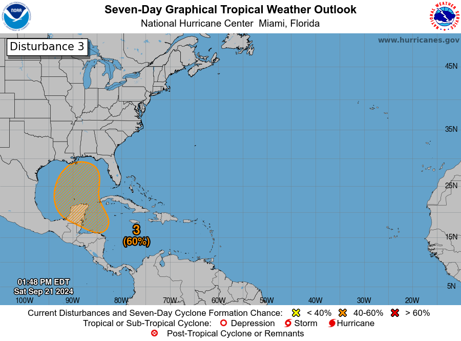
Again, this is a rather conservative view of things, and I anticipate we’ll see this continue to inch up today and tomorrow and push into the “2 day” development map tomorrow or Monday. Modeling is beginning to coalesce around the idea of development north of Honduras or just east of Belize, or on the Caribbean side of the Yucatan. The general theme of the models since yesterday has been to align more with the faster, stronger solutions which would be apt to bring a storm north or north-northeast across the Gulf of Mexico and toward the coast between Louisiana and Florida. There is still a good deal of uncertainty on specifics here, including whether or not it develops. There is still a minority of ensemble members in modeling that struggle to get this going. Not likely to happen, but it’s a non-zero possibility. I just want to highlight that there are reasons this isn’t a 100 percent chance of development right now.
A potential threat to the U.S. Gulf Coast
All that said, I just want to make clear right now that this has the potential to be a strengthening storm in the Gulf, moving north, fairly fast later this coming week. When Francine moved into Louisiana it passed over warm but not super warm waters in the central and western Gulf of Mexico. If this upcoming system tracks farther east of Francine as seems likely, it will be passing over much warmer Gulf waters.
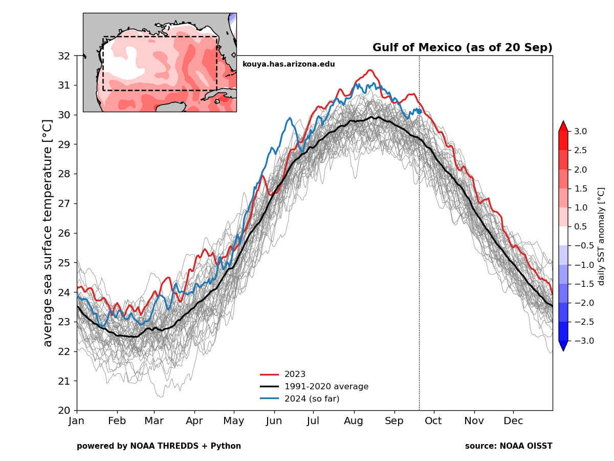
The near-record warmth of the Gulf is being driven almost entirely by the eastern half of the Gulf of Mexico, close to where this system will likely pass.
I don’t want to overstate the risk at this point, but given the scenario (Quick moving, very warm water, generally favorable upper level conditions, and less dry air than Francine contended with), there is some legitimate risk of a significant storm on the central or eastern Gulf Coast late next week. You should be following this forecast closely if you live between Florida and Louisiana, and you should be ready to put your hurricane plans into motion quickly this week once we see further agreement on possibilities.
So what do the models say?
We have seen the operational models reduce the spread between each other considerably in the last 24 hours. We still have some variability on track and timing, but there has been a tendency to push toward a track northward between Louisiana and Florida sometime between Thursday and Sunday next weekend. The odds of the system getting buried off the Yucatan in the Bay of Campeche has dropped off some since yesterday.
Today’s European ensemble at 12z, hot off the presses still shows a very wide spread of possibilities, from a system getting buried in the Bay of Campeche to one tracking southeast into South Florida. But what I pay attention to with these runs is what has changed or where the “clustering” is occurring. If we compare the same image at the same time 24 hours ago, we can see a shift in both the ensemble mean (solid black lines) to the northeast and a decline in the number of Euro ensemble members that bury this system in the Bay of Campeche.
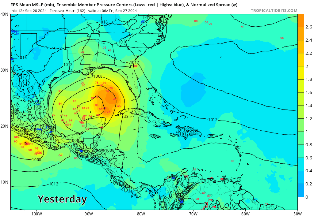
This further indicates that there is a definite trend toward a faster and more progressive storm to the north or northeast within the modeling. We can see further evidence of this in a consistent GFS, the ICON, and the Euro AI model (AIFS) showing similar type of outcomes now.
Why is this? Since yesterday, we have seen a bit of a signal in modeling for a cutoff low or secondary trough to develop over Arkansas or Oklahoma. This is something of a new wrinkle.
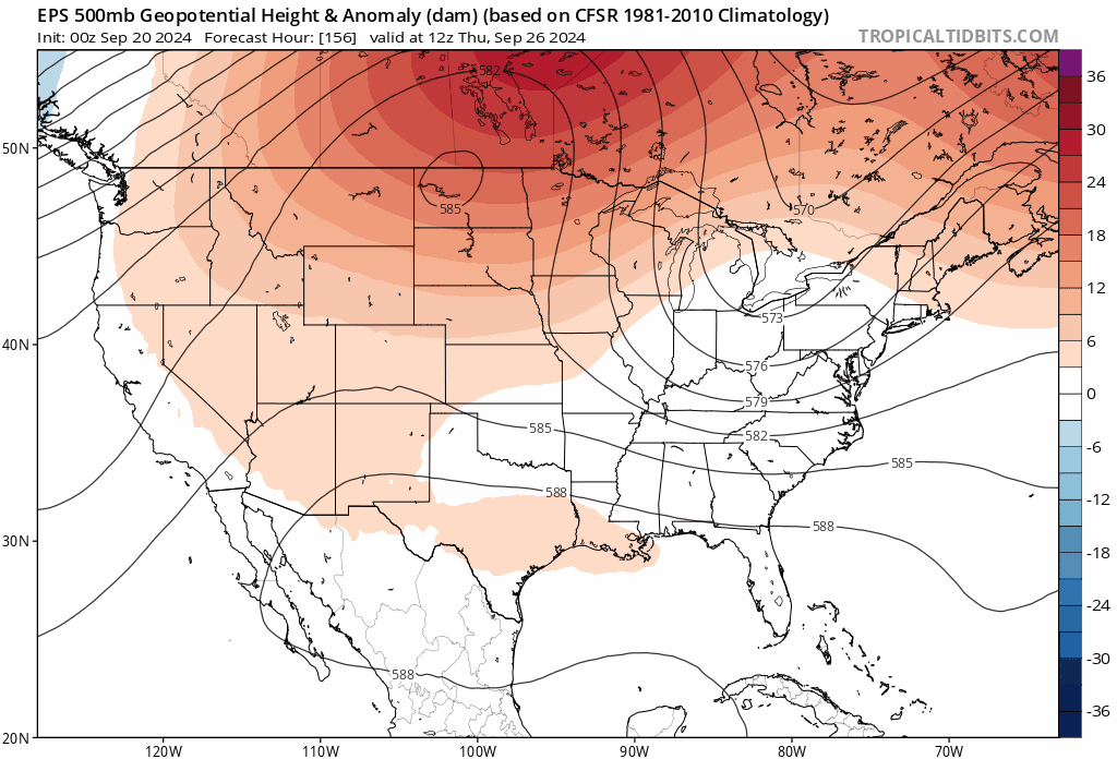
Whatever the case, this slightly stronger and farther east trough is helping to “pull” at the tropical system in the Gulf and force it to the north. This is what is likely shifting the Euro ensemble to the side of the GFS and other modeling now and why we’re seeing some additional agreement develop on a threat to the central or eastern Gulf Coast.
The bottom line: There is building agreement in the modeling that a tropical system is going to come north late this coming week toward the central or eastern U.S. Gulf Coast. While details remain elusive there is enough evidence of a threat to that region that folks should be paying close attention to forecasts and thinking about their plan for later this week should they need to evacuate or hunker down. We’ll have more on this tomorrow.
I enjoy and appreciate your forecasts. I do have a question about the storm . I understand the heat ridge is leaving Texas and moving to Florida what happens then?
Nothing of note right now. As long as things play out as forecast right now, this won’t be our concern here.
What is a cutoff low?
An upper level storm that cuts itself off from the jet stream and sits and meanders a bit til something pushes it away.
Thanks for today’s update!
Days ago, my thought (using a couple different tools) was landfall north-eastern coast of FL. Then next day, wild guessed eastern coastline of LA … yesterday, landfall guess is around Pensacola.
Would be great if it would simply dissipate 🙂 Landfall anywhere is not a good thing.
When would we expect landfall if this develops and heads straight up to LA/AL/FL? Mid- or end of week?
@LNS … wild guess:
Sat 28th early morning.
SOmewhere in the late Thurs-Sat window most likely.
Matt, Thank you. I’m very much on alert now in Gulf Shores AL. I look forward to your analysis tomorrow of developments. Alyce 🫤
Matt…what a super presentation today!!! Thanks!
I have the dumb question about the Today/Yesterday chart with the black lines that form concentric “circles” in the Gulf. Do these lines mean that if you take the average of all the ensemble’s solutions, then the eye of the storm would be at the middle of the smallest circle (the one marked 1004 for the Today) ?
Yeah…basically that’s an average of 50 different ensemble members. It will almost always be washed out and weak, but it importantly offers you context on trends and potentially track as well.
Well, as of 19:34 EDT, the NHC has bumped Caribbean Disturbance 2 to 70 percent.
My daughter is getting married in Gulf Shores this coming Friday. It’s not looking good for a beach wedding at all, is it?
I would be wary. That said, a lot can change in 5 days, and by no means is anything set in stone yet. Just follow the forecasts and see where things go.
As of 12:17am (our time) the National Hurricane Center still shows 70%, with possibly a bit more of a hook to it.
I believe it’s the EURO AI, this morning(Sept 22), I saw a second system come in just behind(by a few days) this current system we are watching..This isn’t the first time over the last week that I noticed this..Is the support still low for the scenario of a second system heading for the same general location a few days later?