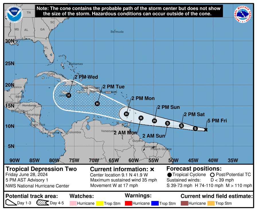
Update (4:40 PM CT Friday): Invest 95L is now Tropical Depression 2, and it is expected to become a formidable hurricane as it moves into the Caribbean.
We will have more on Saturday morning.
Headlines
- Invest 95L is close to depression or tropical storm status.
- It is likely to enter the Southern Caribbean by Monday as a tropical storm or hurricane.
- All the Lesser Antilles should monitor 95L’s progress, but islands south of Martinique (the Windward Islands) stand the highest risk of impacts.
- This is not expected to impact Puerto Rico or the Virgin Islands beyond rough seas or some showers.
- There is a lot of uncertainty on what happens to 95L after Monday or Tuesday.
Invest 95L should become Tropical Storm Beryl before too long
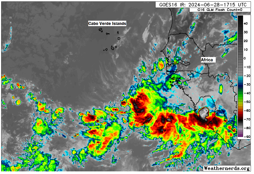
Looking at satellite this morning, and I have to think we are close to a depression here. A tropical storm is probably not too far behind. In fact the latest National Hurricane Center outlook has just upgraded Invest 95L to 100 percent odds of development in the next 48 hours. The disturbance has it mostly together today, and it is nothing short of impressive for this far south and east in late June.
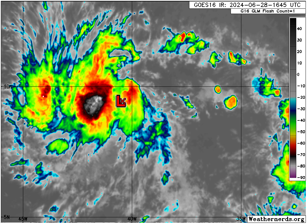
It continues to chug west at a very low latitude (around 9°N or so). Weather models are in impressively good agreement on the next 72 hours of track with 95L, bringing it across the Atlantic and into the Caribbean near 13°N, give or take. This would track it toward Barbados, St. Lucia, or St. Vincent and the Grenadines by Monday morning. At this point, most data keeps this one comfortably south of Puerto Rico and the Virgin Islands.
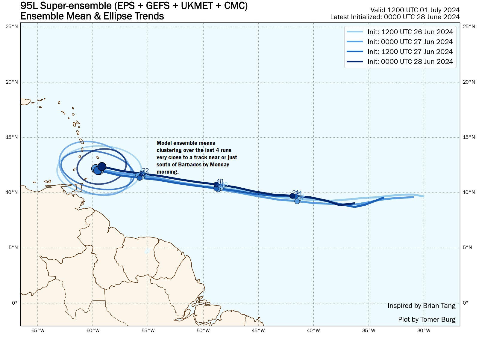
We have good agreement on this, supported by tropical models, operational global models, and ensemble means.
Things get dicier on what this will look like when it gets there. When we look at model guidance that tells us the odds of a storm rapidly intensifying, the SHIPS guidance, it tells us that those chances are running anywhere from two to seven times normal climatological odds. In other words, there is good support for 95L to continue a steady ascension as it approaches the Caribbean. With water temperatures running several degrees above normal in this region, if not at all-time records for this early in the season this seems to make sense. It would wise for folks in the southern Caribbean to prepare for impacts from at least a high-end tropical storm, if not a hurricane late Sunday or Monday. I would anticipate that watches are issued by tonight or Saturday morning.
So what happens from there? It’s tough to hold the Caribbean down in terms of wind shear. There’s a reason it’s referred to as the eastern Caribbean graveyard. As 95L or Beryl or whatever it is passes the islands and works across the southern Caribbean, it will probably start to encounter at least some wind shear. So this likely has about 72 to 96 hours to strengthen before things begin to start countering that.
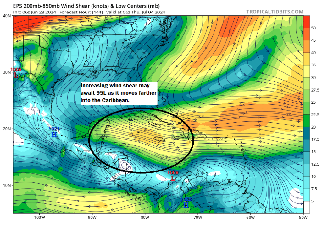
This may also play a role in where 95L goes too. A weaker system would be more prone to stay south, likely tracking toward Central America or the Yucatan, while a stronger system may gain some latitude and eventually become a Gulf concern. So that’s a big issue to watch heading into next week.
When you look at the ensemble guidance from Tomer Burg’s excellent website, you see an interesting change in confidence once 95L gets halfway across the Caribbean.
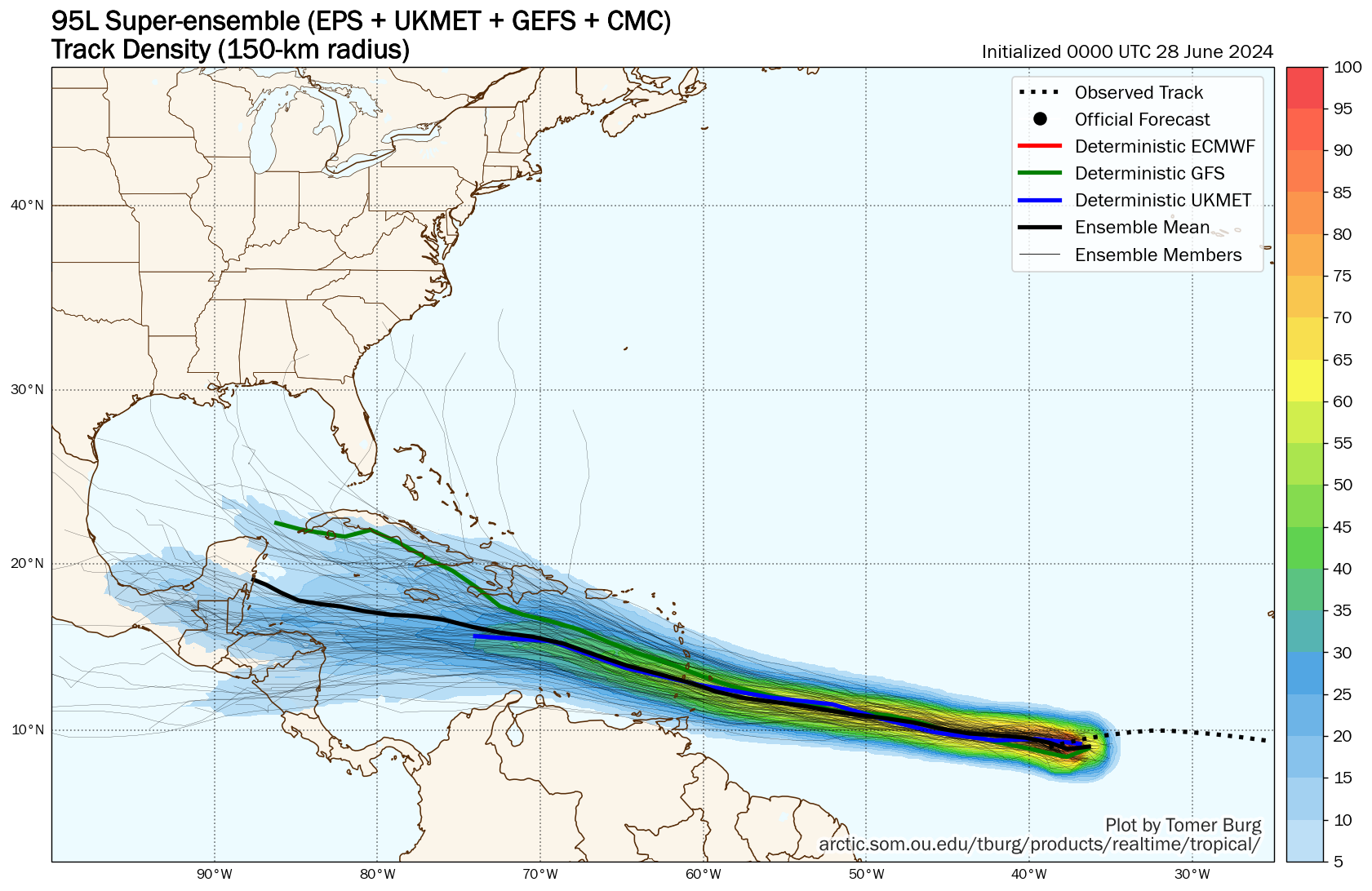
Confidence in track is high, with at least 50 percent of ensemble members in decent agreement until it gets to about 70°W longitude, roughly halfway across the Caribbean. From there, some members (mostly GFS ones) go north, while most go west or west-northwest into the Yucatan or Central America. By late next week, whatever 95L is should be somewhere between about Nicaragua and Cozumel. Guidance implies it would be most likely to continue into Central America or Mexico, but there is still enough uncertainty in both the upper pattern steering 95L (ridging over the Southeast aiding it westward may weaken a bit) and the internal intensity of 95L to keep us on our toes regarding the end game here.
The bottom line: Invest 95L remains a system to watch, and in the near-term folks south of Martinique in the Windward Islands through Trinidad and Tobago should begin to prepare for a tropical storm or hurricane by Monday morning.
Oh, there’s more?
There are a couple more waves behind Invest 95L, which some modeling tries to latch onto for development risks next week.
I’m not sure what to make of any of this yet, as I want to see what 95L does, but suffice to say, it’s abnormally active in the Atlantic right now for late June.
Invest 94L has not quit yet
The NHC continues with a 30 percent chance that Invest 94L will develop before coming ashore in Mexico early next week. Heavy rainfall remains the primary concern for Central America and Mexico with this system over the next few days.
Does the Saharan Dust play at all into this? The news has been talking about that reaching the Texas area this weekend, but there’s not been any correlation talk on how it may or may not impact what’s coming off of Africa right now.
In years past we usually hear that X storm won’t have an impact because of the Sahara Dust.
It does. But 95L is far enough south to avoid the dust for now. If it tracked farther north, that would certainly complicate matters for it though. Sahara dust being present doesn’t guarantee anything, but it can/does slow development. But with a system this far south, it’s a little more insulated.
Didn’t we have two June tropical systems in the Atlantic last year?
Yep…Bret and Cindy went back to back. Becoming more common.
Keeping an eye on this, as I live in Seabrook and will be driving across to Florida and back again for the second week of July 😕. Hopefu everything stays south.
We are supposed to head on a cruise to bahamas next week and fly into Miami! 🙁 also hoping it stays south!!
I’m a Houstonian traveling in Nicaragua (western side) for the next two weeks. How many days would you suggest until we pay real close attention to the models?
You’ve got about 3-4 more days probably. Once it’s in the islands, we’ll have a better idea of how strong it got and what that may mean down the line.
Thank you!
I thought a further limitation on the development might also be with regard to Saharan Dust.
Its south of Saharan dust, so no interference from it
With it now a TD, and expected to be a hurricane, is it now favoring the northern track into the Gulf?
Way too early to say.
Is there a website that would show the predicted Caribbean wind shear for time when this storm hopefully encounters it?
This site says there will be some wind shear to hinder it, the NHC is saying abnormally favorable conditions. Not sure what to make of that.
Of course, after posting that the NHC’s next update mentions the wind shear.
Could Beryl dredge up colder water that might discourage the wave coming right behind it, or is the hot water too deep?
Yes it probably will. But whether that’s enough to make a meaningful impact is TBD. That said, most model guidance agrees that the follow up wave will struggle a bit more than Beryl. Or at least develop more slowly.