One look at the satellite image over the Atlantic this morning, and it’s sensible to ask what month it is currently. Even when one factors in the idea that we’ve been able to name more small storms in recent years, this is a bit ridiculous.
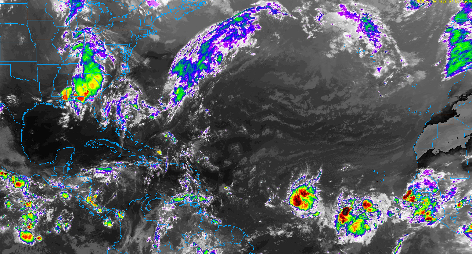
Thankfully, both systems of note in the Atlantic will probably have relatively short shelf-lives, but folks in the Lesser Antilles, Virgin Islands, and Puerto Rico should monitor the progress of these systems.
One-sentence summary
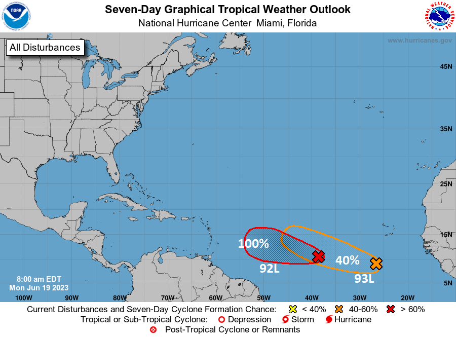
Two disturbances in the Atlantic, Invest 92L and Invest 93L have been given 100 percent and 40 percent chances (respectively) of developing this week and could become depressions or named storms in the coming days.
Happening now: Investment prospectus
Two invests means two systems to discuss, so let’s take a look at their futures.
Invest 92L
Looking at Invest 92L this morning closer in on satellite, it’s pretty clear that this is almost ready to go.
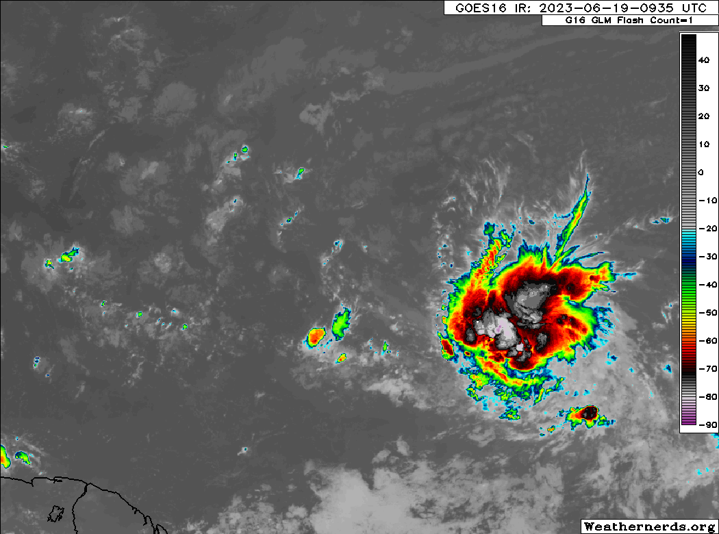
After struggling for a couple days, the thunderstorms seem to have consolidated and there is a noticeable “spin” to the disturbance. This is likely going to become a depression not long after we publish this post.
Over the next couple days, the question becomes how much better organized 92L gets. Let’s look first at atmospheric moisture tomorrow evening.
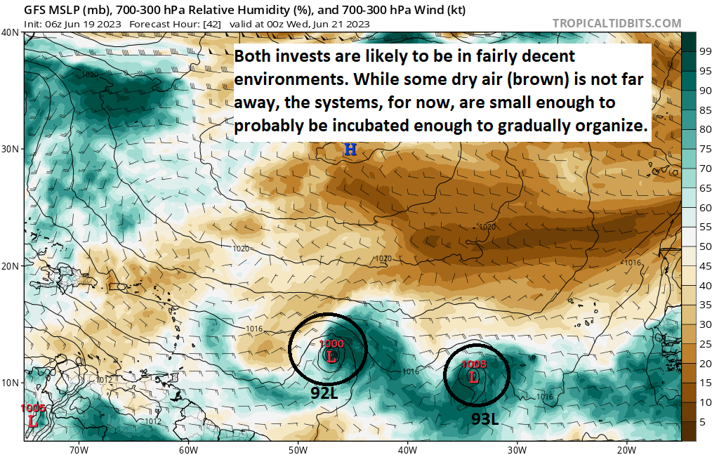
Both systems are highlighted above, but looking at 92L specifically, it looks good into Tuesday evening, with ample moisture and dry air off to the north and west and far enough away for now to prevent problems for development.
What about wind shear?
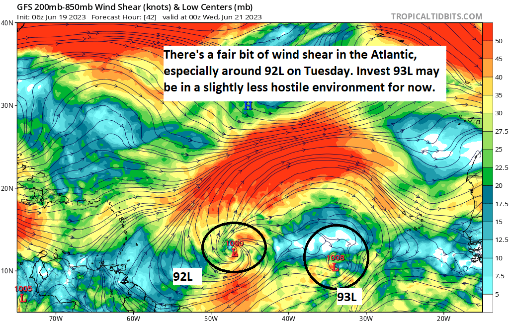
I don’t think that shear will be prohibitive to 92L, but it may keep it from intensifying as much as some models have been saying. By tomorrow evening, it’s dealing with a fair bit of shear “in the neighborhood” but perhaps not enough to keep it from becoming a tropical storm.
So where will this system go? Obviously, that’s the $10,000 question. We have enough clues in the data to make a decent call of at least what to watch and when to watch it for planning purposes in the Lesser Antilles, Virgin Islands, and Puerto Rico. If we use the GFS ensemble as a guide, we can see that 92L’s intensity is likely to “peak” in about 72 to 96 hours, or on Wednesday/Thursday. When you run 30+ different versions of the model to generate the ensemble, you get the map below.
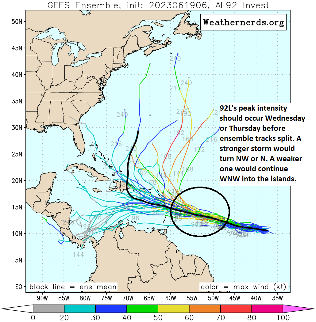
From this point, the GFS ensemble at least takes stronger outcomes more north into the open Atlantic while weaker ones (with 1 or 2 exceptions) track into the Caribbean. It’s notable that all the European ensemble members (not shown) keep 92L weaker and track it into the Caribbean. But I prefer using the GFS ensemble as a guide, as it opens up a wider array of options for us to see right now.
Beyond day 3 or 4, it seems likely that whatever 92L becomes is going to run into a good bit of northerly shear and some broader dry air that could lead to it becoming less organized. This is why we believe that if it makes it to the islands or Caribbean, it will likely do so as a tropical storm and rain producer, certainly not without hazards but something a little less extreme for late June. But we’ll have a good idea by midweek of what this does and who it impacts.
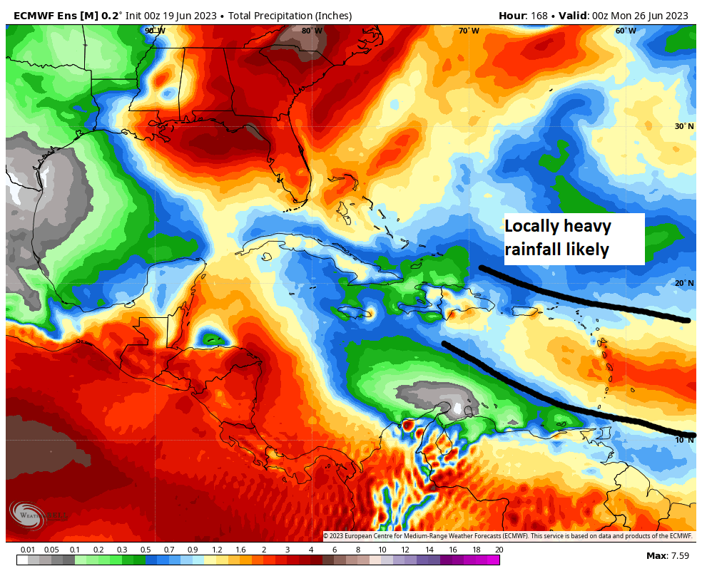
If we look at the European ensemble mean for rainfall over the next 7 days, we can see a corridor of locally heavy rain that moves into the Lesser Antilles, with Guadeloupe through St. Lucia being in the heaviest rain. Depending on intensity and exact track, that “bullseye” could shift north or south a bit. For now, the ensemble mean prints out 1 to 4 inches of rain, but there could be some locations that see more and some flooding concerns, again depending on track and intensity, a picture that should become clearer later this week.
Invest 93L
From the maps above, it’s clear that Invest 93L is going to be in a slightly more intriguing environment for development. Much like 92L, how well organized this gets will lead to some track outcome, with a better organized disturbance likely turning northwest before the Caribbean and a less organized one likely following 92L to the west and into the islands. I want to see more of how 92L behaves before worrying much about 93L, and besides 92L is the more immediate system to watch for the islands.
The medium range (days 6-10): More to come?
It seems funny that for the last 2 weeks the GFS operational model has been all about the western Caribbean and yet it’s the Atlantic that’s off to the races. There are some signs in the models that a third disturbance emerging off Africa may be something that could develop over the weekend or next week. Much like 92L and 93L, it seems unlikely it will become a big deal but this meteorologist can’t recall a busier late June in the deep Atlantic in recent memory, if ever. Of course, record warm water temperatures in the Atlantic likely mean record-type outcomes, despite El Niño.
Fantasyland (beyond day 10): Calmer?
As of right now, a cursory glance at operational models and ensembles seems to indicate that things may begin to quiet down some heading into July. We’ll see.
Follow our social media for any updates should 92L develop today.
Twitter
Instagram
Facebook
TikTok
Otherwise, we’ll be back with you on Tuesday morning.
For some reason, I haven’t been receiving any of your daily emails. Would you please check to make sure I’m on your email list for all future updates? I miss your daily emails! Thank you!
Love The Eyewall! Useful and educational at the same time! Thank you!
Since 92L and 93L appear to be fairly close to each other, is there a chance that they could combine and create a stronger system better able to deal with dry conditions and wind shear?
Nope…in a situation like that (rare but it does happen from time to time), the systems would actually impart more of a destructive interference on each other and probably limit intensity levels of whichever became dominant. We saw that in 2020 with Marco and Laura a bit, where Laura became dominant and Marco basically evaporated in the Gulf.
Thanks for the reply and clarification, Matt. Really appreciate what you and Eric are doing.
So happy to find your new site after moving from HTX to Puerto Rico!
I’m supposed to go to Puerto Rico on Sunday. I thought June would be safe…
We are currently in the Virgin Islands on vacation. We can’t thank you enough for your reports!
High pressure is expected over Texas into next week. Will that cause Bret to go south and away from Texas?