Good morning. Tropical Storm Bret continues to churn west in the Atlantic, working its way toward the Caribbean. It’s very clearly running into some challenges that are impeding it from strengthening a whole lot at this point, and it has about 24 to 36 hours left before those challenges get even more difficult to fend off.
One-sentence summary
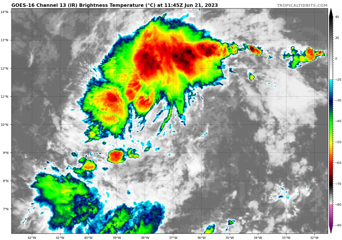
Tropical Storm Bret, ragged as it looks this morning, could bring heavy rain and tropical storm conditions to several islands in the Lesser Antilles tomorrow before steadily weakening once it enters the Caribbean.
Happening now: Bret feeling the thorns of the rose
Besides Bret, we continue to watch Invest 93L, which has an 80 percent chance of developing over the next several days. More on that below. First, let’s walk through our main item.
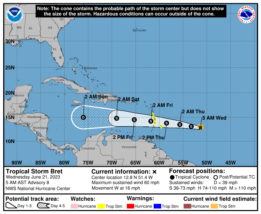
Tropical Storm Bret
As of the 5 AM advisory, Bret is a moderately strong tropical storm with 60 mph winds. Tropical Storm Watches have been posted for Barbados, Dominica, Martinique, and St. Lucia. Those should be adjusted or expanded later today.
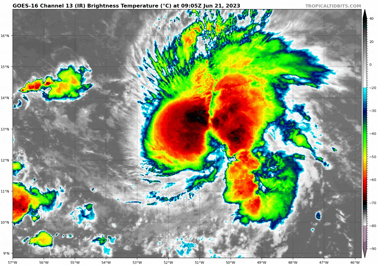
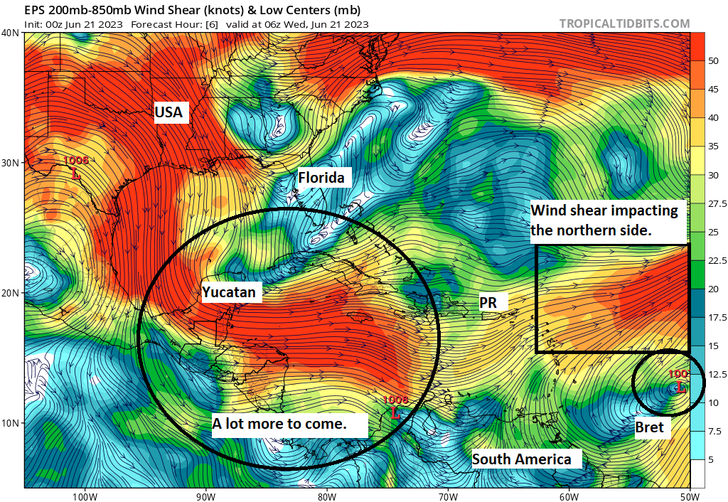
The environment around Bret is a bit tough right now. There is about 20 to 40 knots of westerly wind shear zipping across the northern quarter of Bret’s circulation. In the satellite loop above, you can see how ragged the northern half of Bret looks compared to the southern half, and that’s likely due to wind shear. On the northwestern side of Bret, there is a bit of dry air as well. Because of Bret’s size (it’s got a fairly large circulation), it can’t quite fend that off completely. In fact, Bret’s size may be working against it some, as it is being exposed to more adversity than a smaller storm might be.
So to summarize: Bret is an acceptable tropical storm by June standards for sure, but it is dealing with some dry air and a good bit of wind shear that will probably cap Bret’s intensity and trend it weaker as it moves into the Caribbean. An Air Force reserve hurricane hunter aircraft is expected to investigate Bret today to get a better idea of what’s happening out there.
From here, Bret’s track is pretty straightforward. Virtually all of the hurricane models and global models and ensembles are in good agreement that Bret will basically track due west or just north of due west into the Caribbean, somewhere between about Dominica and St. Vincent, and near or just north of Barbados. Because of Bret’s size, many of the Leeward and Windward Islands will experience heavy rain and some version of tropical storm conditions. Because of Bret’s speed, those conditions will probably pass relatively fast.
Virtually all models have Bret degenerating into a depression by Saturday. Its remnants should continue west toward Central America, bringing some locally heavy rain along the way.
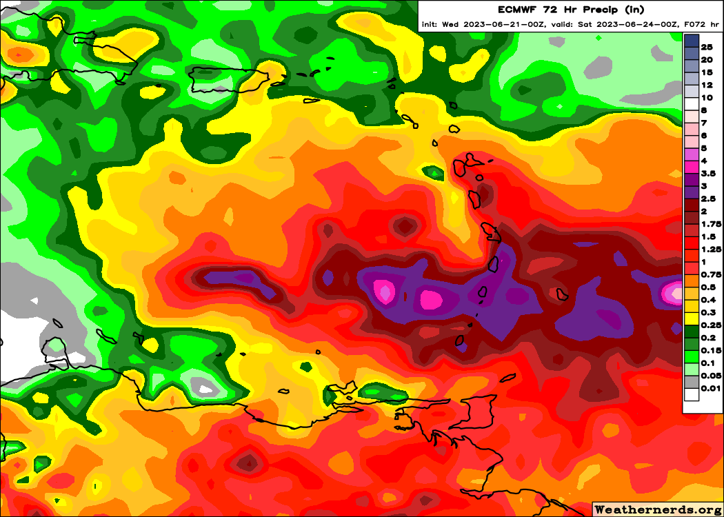
Rain totals are expected to be on the order of 1 to 4 inches from Bret due to its speed and disorganization as it tracks through the islands. Max rain totals will probably occur somewhere between Martinique and Grenada. For Puerto Rico, the Virgin Islands, and Hispaniola minimal direct impacts are expected, though seas could be a bit choppy.
Invest 93L
Meanwhile, we continue to watch Invest 93L behind Bret.
It still needs a bit of work before we start seriously considering this for upgrade status to a depression. But, it’s certainly got a good bit of storms with it, which doesn’t hurt. At this point, 93L is expected to turn northwest as it comes west, passing north of the islands and out to sea. It too will likely have a window to develop before it hits wind shear that overwhelms it and leads to weakening. Something to keep tabs on but nothing to worry much over at this time.
The medium range (days 6-10): Ain’t no party like an MDR party
The main development region (MDR) of the tropical Atlantic is more on fire than Stockton & Malone in NBA Jam (though I was more of a Barkley/Majerle guy myself). Behind Bret and 93L lies another tropical wave that will make an effort to develop in the medium range. Whether it does or does not is TBD, but even the fact that we’re talking about three systems in late June in the deep tropics is virtually unheard of. This next wave may be a bit too far south to really get going, but we’ll see.
Fantasyland (beyond day 10): Some pattern shuffling in the U.S. & Atlantic?
At this time, we don’t believe any systems will become notable in the day 10 to 15 timeframe, but there may be a little reason to watch some things. The pattern in the Atlantic, as well as high pressure responsible for extreme heat over Texas and Mexico are helping to direct traffic either out to sea or toward Central America as weak disturbances. But once we get into the day 10 to 15 timeframe, the pattern may change some. We will detail what that means in the coming days, but to reiterate, we have nothing specific to watch beyond day 10 right now.
I love how your windshear map shows the proper distinction between Florida and the rest of the US.
I love how informative these posts are. So far since I’ve signed up for post notifications, there’s been references to Chris Farley and NBA jam. You guys are the best!
It’s a little more Xennial humor than anything. We will need to work on more Millennial and Gen Z references down the line too! 🙂
Could this be the story of the season? Lots of MDR storms, but they struggle when they get to the Caribbean because of El Nino, while we can see a ton of fish storms because they form to quickly in the MDR due to warm water?
I think this is a reasonable possibility. Is it what I *expect?* Not necessarily, but I think it has a decent chance of happening. I was saying to someone yesterday that if we have lots of Arlenes and Brets, it makes for an active season but a low heartburn, low impact one — which is fine by me!
Please be sure to annotate the graphics/pictures you use to land relationships more often as you did in one of Windshear of Bret. It provides a greater understanding. Thanks.
We will effort to do that more frequently. Not always easy to do due to time constraints, but we will try!
Awesome stuff 😎
I’m so grateful for your posts this summer ☺️
🌬⚘
Thank you!
Chekhov’s NBA Jam principle states that once NBA Jam is referenced, “boom shakalaka” must be deployed before the hurricane season is over.
I am so grateful for your post…we were in Hurricane Harvey and lost everything.. Praying we don’t get another one but I guess we will see…Thank you for the post😊