In brief: With the GFS model showing its first real scareicane of the season, we take a look at the facts and discuss the real potential of tropical development in the second week of June. Verdict? You don’t need to get too worked up.
Hurricane season hasn’t even officially opened in the Atlantic yet, and we’ve already got foreboding headlines about the first possible threat. A colleague of mine pointed out a Newsweek article referencing an AccuWeather outlook that suggests tropical development is possible between June 6th and June 13th. Seek it out if you wish, I am not linking to it in here.
We’ve also seen the GFS model show some solutions for tropical development in the Gulf over the next 10-12 days or so. As you can see from the last 10 runs of the GFS model forecast for 00z Tuesday the 10th (evening of Monday the 9th), there is zero consistency on where this goes or how strong it will be.
In fact, this is very, very normal behavior for the GFS operational model this time of year. Notoriously, the GFS tends to flex in May and early June with numerous threats, not to say it isn’t periodically correct! But in reality, this is what we refer to as a model bias. In other words, the model likes to frequently exaggerate threats this time of year.
So in this case, is there merit to the potential of tropical development in about 8 to 10 days in the northwest Caribbean or southern Gulf? Maybe but not significantly so at this time. The GFS ensemble is showing some support for a possible northwest Caribbean system. The European ensemble has little support for this. The other operational guidance that can see out past 7 days is generally benign, including the ICON (through 180 hours), the European AI model (AIFS), and the European operational model. No signal shows up on any of those for anything organized.
Several things can be simultaneously true:
1.) It is normal for tropical systems to develop in the western Caribbean and southern Gulf in June.
2.) The models do show some semblance of moisture and weak “spin” in the atmosphere in that region in about 6 to 8 days.
3.) The GFS model has been eager about development, but it has historically had a poor track record this time of year in this exact spot and situation.
4.) No other model support really exists for organized development at this time.
5.) You do not need to worry about tropical development at this time.
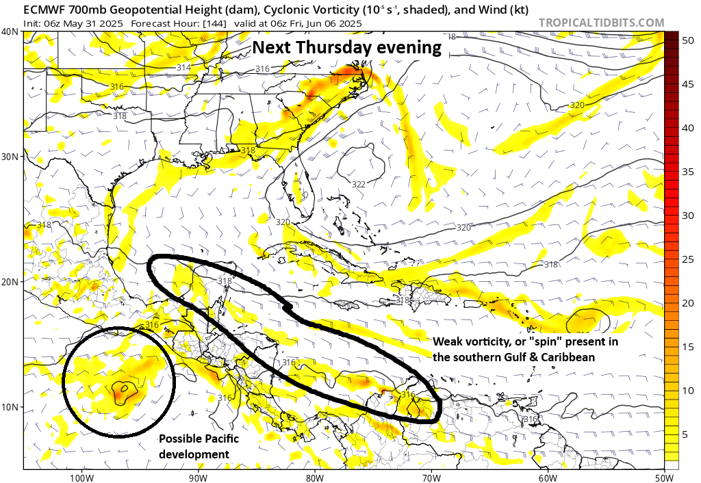
Interestingly, when we deal with these sorts of scenarios, where Pacific development occurs not too far off the coast of southern Mexico, models can sometimes struggle to resolve exactly what or where the system develops. In the GFS’s case, it seems to be wrapping a secondary vorticity maximum (spin) around the east side of the broader circulation in the Pacific, which is what it homes in on to develop in the eastern Gulf. The GFS solution is unlikely to verify as shown. However, the overarching theme does seem to favor more unsettled weather in the Caribbean later next week. I’m not quite ready to say that there is a good chance of tropical development, merely perhaps a slight chance.
I want to remind folks that hurricane season is a six-month slog. It’s not a marathon; it’s an ultra-marathon. News organizations are going to jump on the first iteration of anything they see this season, as they usually do. Even if the reporting is tame and mostly accurate, as it is in this case, there is an implication in the headlines that a serious threat exists, and there is a tendency to bombard people with that. It can get exhausting. One of our goals is to give signal to the noise. Why do we think what we think? Being from Houston, we know firsthand how badly disasters can mess with you mentally when new threats emerge and how important word choice is ahead of storms. This is partially why we want to cover the rest of the Atlantic and U.S. as a source you can trust ahead of hurricanes or extreme weather. Hopefully this does just that for storm-weary Florida folks now.
I read that the Saharan dust movement actually suppresses storms, is this true?
Yes.
SCAREICANE is a great term for the CONSTANT FEAR thrown on the public non-stop!!!
Ty Matt! I had fallen for it – this article really helped 🌹
Today’s report exemplifies exactly why I choose Space City Weather for a daily “no hype” weather update. I’ve been an avid fan since 2017 with the onset of hurricane Harvey. I trust and appreciate your knowledge in reporting the weather.
Thank you for your no nonsense, calming posts. I am one with high weather anxiety due to the severity of regular storms nowadays, so your posts are very valuable to me to keep my anxiety in check. Keep up the good work.
💓
Yes to all previous comments. I also fell for the scare hype. I have given up msm and pay too much for a bunch of substacks, but know i would pay for Eyewall in a heartbeat. Thank you for mitigating what seems to be constant anxiety with careful words and reliable facts.
Scaricane!!! 🤣 A great addition to the English language!!!
AccuWeather? Isn’t that Bastardi territory?
What does this mean for cruise travel to the Yucatan? Best guess on dates affected?
I never pay any attention to anyone but you guys. Had 5′ of Buffalo Bayou running through my house with Harvey and that’s when I found you. No hype!!
In addition to your refreshingly accurate article, I’m also encouraged to see the correct usage of “homes in on.” Well done. 🙂