In brief: A major coastal storm will produce heavy rain, gusty winds, severe beach erosion and potentially major coastal flooding from North Carolina through New Jersey, Long Island, and southern New England this weekend and early next week. Tropical Storm Jerry will brush past the Leeward Islands today. And the Desert Southwest is primed for a major rainfall event courtesy of Priscilla, with significant flash flooding possible tomorrow.
Major coastal storm in the Mid-Atlantic through Southern New England
The threat of a coastal storm this weekend with significant impacts in the Mid-Atlantic and perhaps as far north as New England continues to increase. We now have various watches and advisories posted along the coast from the Carolinas through New Jersey.
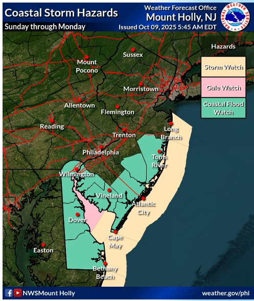
Areas across the Mid-Atlantic, particularly from Virginia up through New Jersey and Long Island it seems may be vulnerable to significant coastal flooding, strong winds, very rough surf, and potentially severe beach erosion. The general theme is that low pressure will form later tomorrow or early Saturday off the South Carolina coast. It should come north past North Carolina, before it slams on the brakes near the Jersey Shore or Long Island. From there, it will sit and spin for a day or so before eventually circling back south and southeast out farther into the ocean.
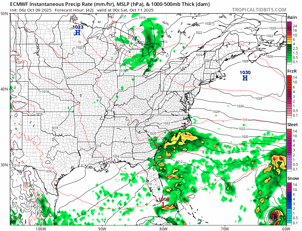
It is a long, drawn out, complex storm track. And that’s one of the problems with this. This will help assist in multiple high tide cycles of significant impacts from Virginia into New England. On the backside of the storm, there will be sound-driven impacts as well in North Carolina. In addition to the marine impacts, there will be rainfall. Anywhere from 2 to 4 inches or higher amounts will be possible along the coast into New England.
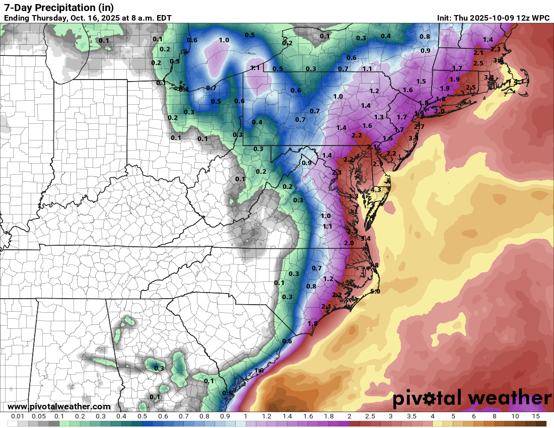
For New England, given the drought situation, this will be a beneficial rain for sure. Along the immediate coast, however, the heavier rainfall may exacerbate the coastal flooding.
In addition to the rain, winds will buffet the coast pretty substantially. There is a better than 50 percent chance of 55 mph wind gusts on the Jersey Shore, possibly up to coastal Long Island and south into Delmarva as well.
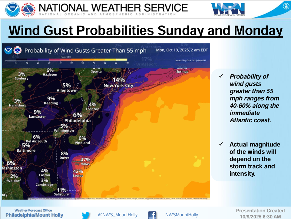
As noted in the above graphic, the track of the storm and intensity of the storm will dictate just how strong winds get. The European model shows wind gust risk of 40 to 60 mph almost continuously from Sunday through Tuesday along the immediate coast of New Jersey and Long Island. Keep in mind that the winds *will* drop off as you go inland, and the vast majority of concerns and risks with this system will be on the barrier islands and immediate few miles of the coast.
But again, it’s notable that marine impacts like tidal flooding and beach erosion look so significant this far out. We’ve been talking about this all week, and it has held firm on these impacts. For folks from coastal Delmarva to the Jersey Shore to Long Island, it will be important to be prepared for what should be equivalent to a powerful nor’easter.
Tropical Storm Jerry

Jerry remains in somewhat rough shape this morning, looking very much as though wind shear is enacting a toll. Still, it’s a formidable tropical storm despite the frazzled appearance, with max winds of 65 mph on the east side of the storm. But it does not appear to be making a run to hurricane intensity just yet.
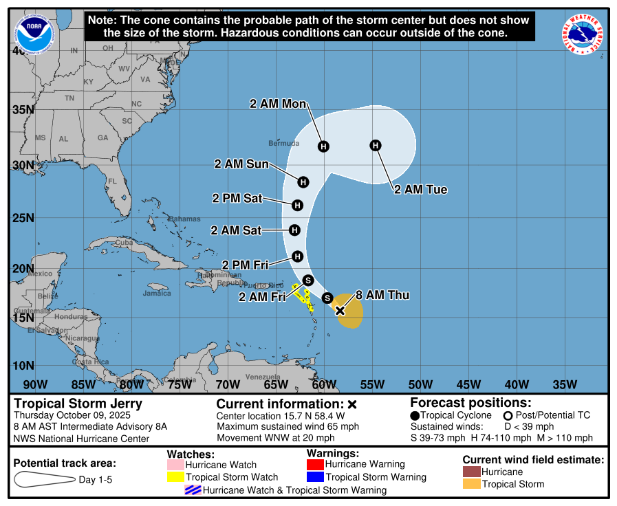
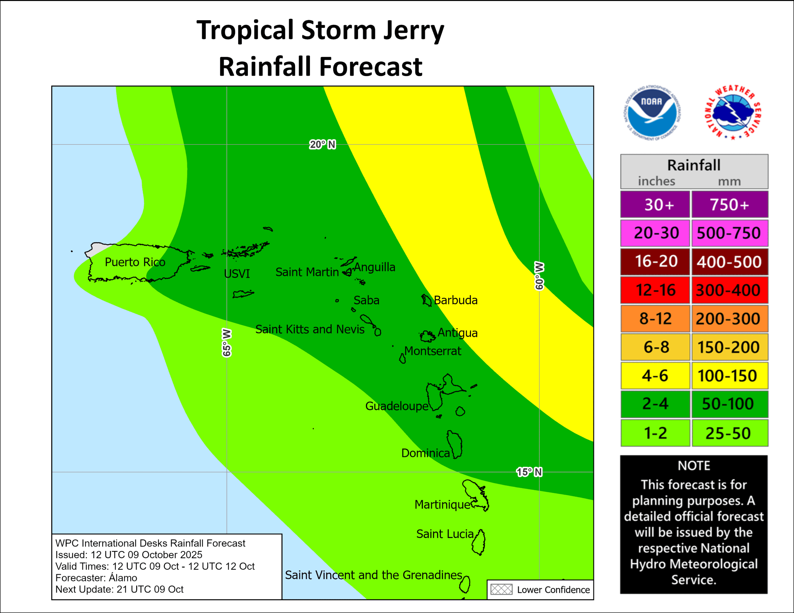
Jerry will pass just northeast of the islands today, brushing some of them with tropical storm impacts, particularly Antigua and Barbuda but also some of the adjacent islands. Thankfully, Jerry is quite a lopsided storm at this time, with the majority of its wind on the eastern side. With the slightly calmer winds of the western side impacting the islands, this should help mitigate impacts and rainfall some.
Thankfully, Jerry is moving along fairly quickly and will shift off to the north and head out to sea tomorrow. Model agreement is strong that Jerry will pass well south and east of Bermuda, no further threat to land.
Desert Southwest rains
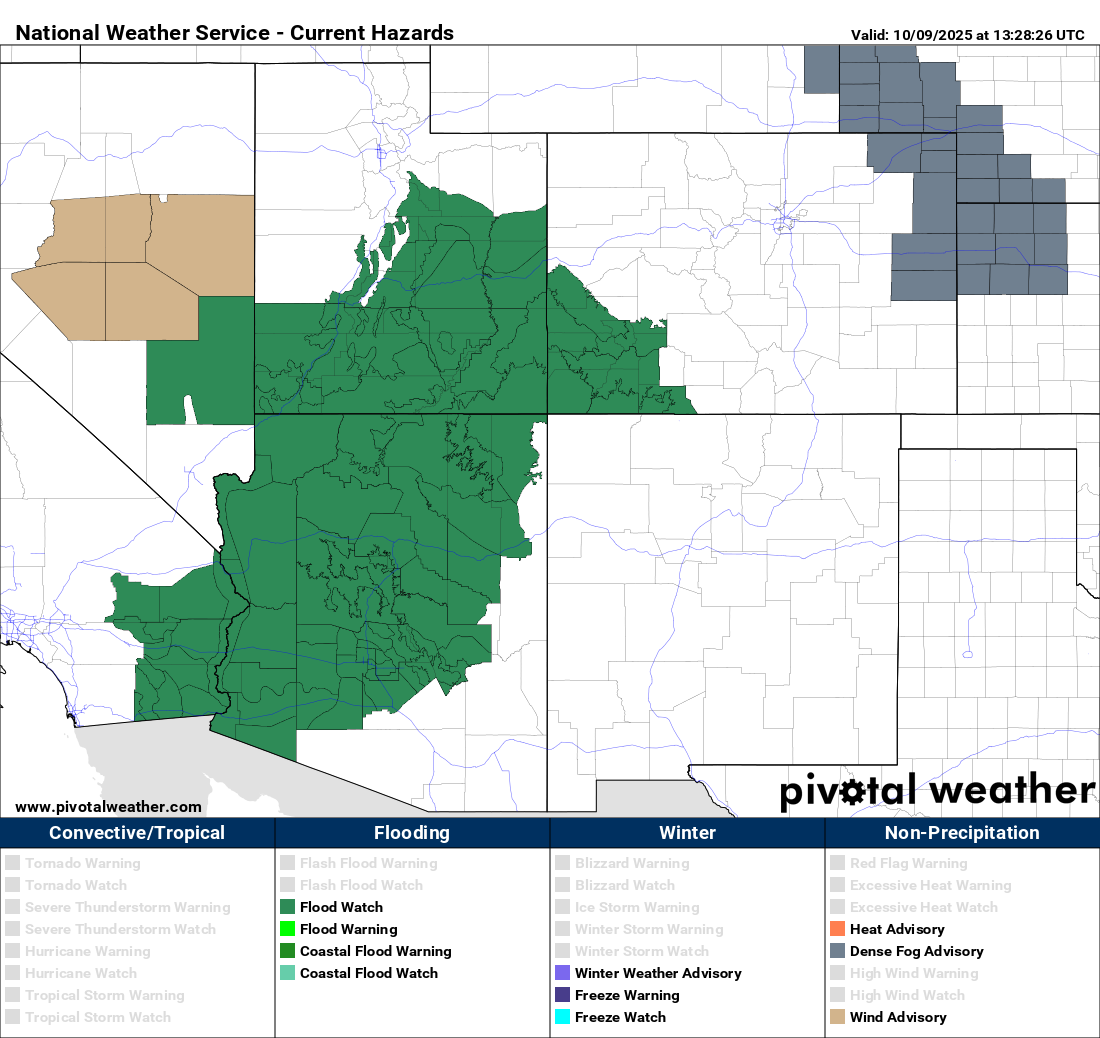
Flood watches are now posted across Arizona, southern Utah, southwest Colorado, and even parts of Nevada and California, in anticipation of several days of heavy rain chances thanks to tropical moisture coming out of the Pacific.
Much of interior Arizona is in a moderate risk (level 3/4) for excessive rainfall and flooding tomorrow. Slight risks (2/4) cover much of the rest of the region including for today and Saturday, as well as Sunday and Monday in southeast Arizona and New Mexico. Moisture surges north today and tomorrow, peaking in interior Arizona tomorrow afternoon into Saturday before sagging back south again Sunday and Monday.
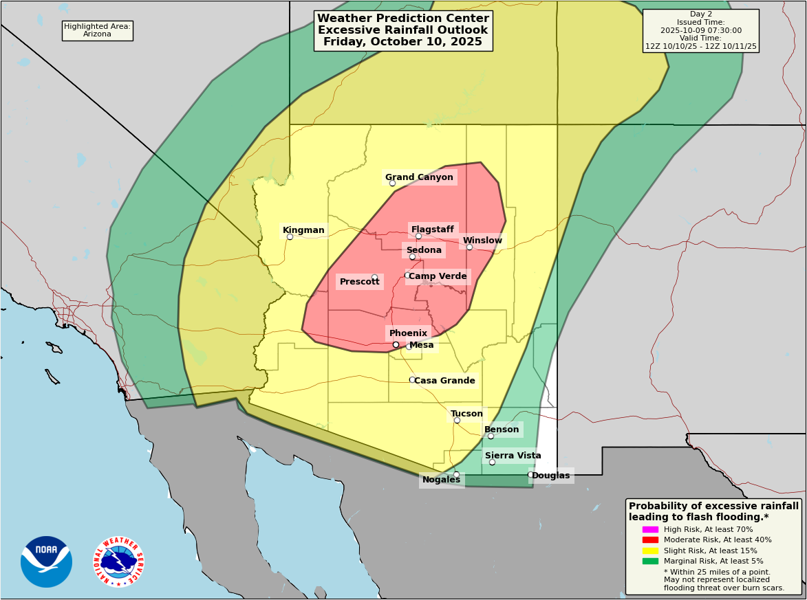
All told, we could see as much as 2 to 4 inches of rain across Arizona, portions of southwest Colorado, and Utah. Additional heavy rain will be possible into New Mexico heading into the weekend.
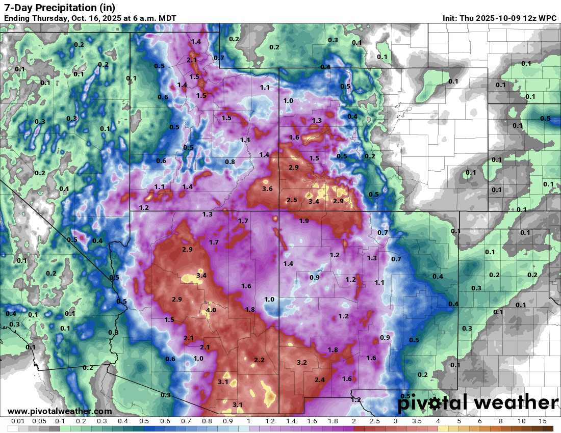
While this is assuredly welcome rainfall, there will likely be some flash flooding and potentially some serious flash flooding as a result of this event over the next couple days. This is especially important in parts of the desert. If you are visiting the national parks in this region, particularly with the government shutdown possibly reducing staffing in some spots, please make sure you are well aware of your location, surroundings, and the risk of flash flooding. There are some washes, rivers, and canyons that are notorious for severe, rapid-onset flash flooding that can stun you. So please exercise extreme caution, especially if hiking in this part of the country.