Headlines
- Milton remains a powerful category 4 hurricane, expanding in size.
- The track should take it somewhere between Tampa Bay and Cape Coral late this evening.
- Widespread impacts are expected on the west (and east) coasts of Florida, as well as inland with power outages, flooding from rainfall, wind damage, and storm surge.
- The worst of the surge will impact near and just south of where Milton’s center crosses the Florida coast. A 10 to 15 foot surge is likely in that nearby area, with significant surge beyond that as well, down to Fort Myers Beach or even farther south.
- 12 to 16 inches of rain will cause significant flash flooding between Tampa and Daytona.
- Isolated tornadoes are possible.
Hurricane Milton is beginning to impact Florida directly now. Outer rain bands are moving ashore, and the bands offshore definitely look pretty nasty with possible waterspouts. We’re also beginning to see how Milton’s asymmetry will lead to substantially higher rain totals along and north of the path of the center.
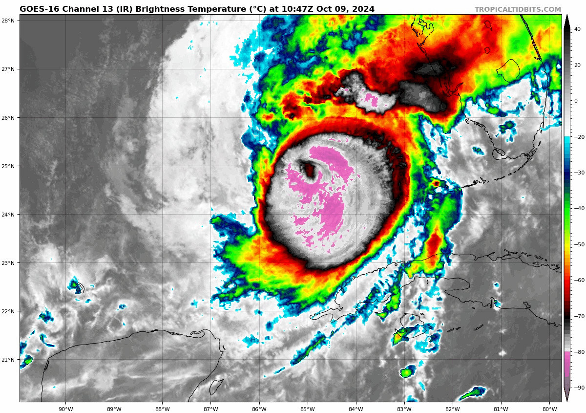
The winds are currently down to 155 mph, making Milton a top end category 4 storm. Hurricane-force winds extend out 30 miles from the center and tropical storm force winds extend out 125 miles, still reasonably close in size to yesterday’s reports. Further expansion of the wind field is expected today. Basically, as Milton’s top end winds drop, it’s moderate to strong winds will expand to cover a larger area. It’s a poisonous trade off, and while it’s accurate to say that Milton will “weaken” today, it’s also accurate to say it is becoming somewhat more dangerous.
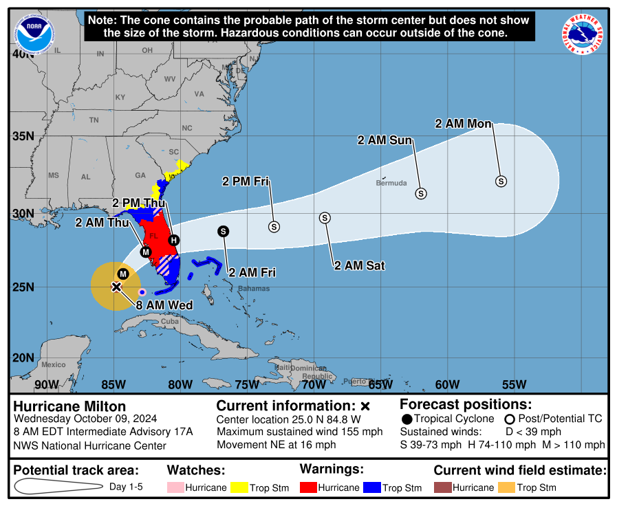
The track is pretty straightforward. Milton will continue northeast over the next 12 hours before beginning to turn more to the east-northeast as it crosses Florida. Milton is going to undergo what we call extratropical transition. Basically, since we’re in autumn, with a big cold front sweeping in, Milton will be absorbed into the jet stream.
On the one hand, this isn’t great because it will lead to an expansion in the wind field as it crosses Florida, and it will also lengthen the wind, as the backside of the storm will continue to have strong wind moving across Florida. On the other hand, this will help the post-storm recovery weather be somewhat cooler and less humid. That cannot go without saying.
Bottom line: A major hurricane with a growing wind field and long duration of wind will be likely tonight and tomorrow morning across Florida, particularly near and north of the track.
Will Milton avoid the Tampa Bay disaster? It’s possible. Most modeling currently takes it south of Tampa Bay, uncomfortably close and within the “margin of error” but still skewed to the south. Here’s the GFS operational forecast model trend of the last several runs, with the “X” indicating Milton’s actual center point.
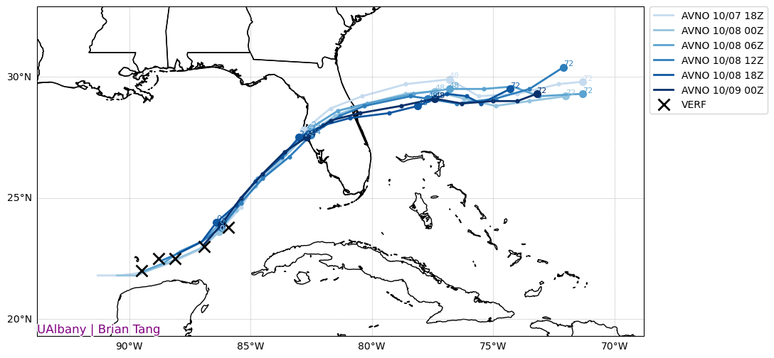
You can see how Milton has begun to drift off course relative to most recent GFS runs, or at least on the south side of guidance. I chose the GFS because it has been rather consistent in showing a hit very near Tampa Bay. These trends indicate that there is some potential the landfall point may be coming south. Would I sound an all-clear for Tampa? Not at all; this is still within the margin of error as I said. But if you want good news in Tampa specifically, this may be it. Unfortunately someone has to get the surge. And the area between Sarasota and Cape Coral may be at highest risk now for a 10 to 15 foot surge. The peak surge forecast has nudged southward a bit today.
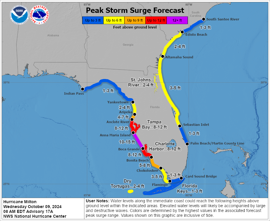
A very bad storm surge will come in on the Suncoast and south to the Lee Island Coast. Where the worst comes in will be dictated by exactly where the center goes, something we’ll monitor today.
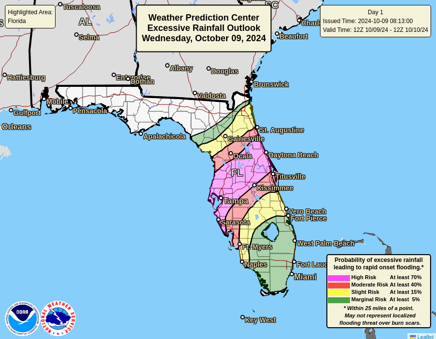
Heavy rains of 12 to 16 inches continue to look likely across the I-4 corridor which will produce significant, possibly damaging flash flooding. A high risk (level 4/4) is posted for this region for that flooding. Additionally, isolated tornadoes will be possible.
Bottom line: Milton remains a serious threat to cause significant damage and disruption on the west-central coast of Florida with flooding rains and power outages inland. We will update again around or just before the 5 PM ET advisory.
🙏🏻💙🙏🏻 FL
Thanks. Looking forward to one more update before it arrives. Appreciate your analysis.
I’m sorry for Florida but I’m happy it has gone past our front door.
Right now the eye of the storm is less than 200 miles from land, yet the tracking cone is almost 100 miles wide along the coast of Florida. Why is there so much uncertainty when the storm is so close?