Headlines
- Milton has returned to category 5 intensity and increased in size by 33 percent since this morning.
- Landfall is still expected late tomorrow night on Florida’s west coast. Some track adjustments were made perhaps nudging it a bit to the south today.
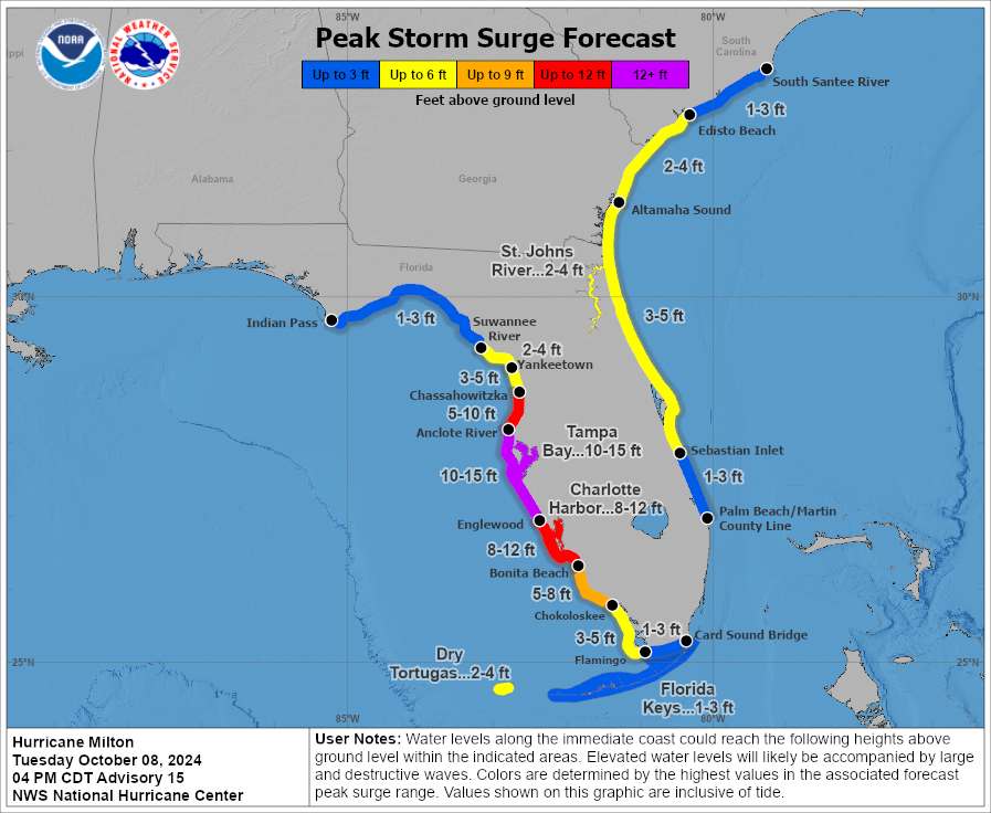
- Surge remains the biggest concern with terrible surge expected between Sarasota and Port Charlotte and very bad surge, still just under Ian levels south of there through Fort Myers. But it’s getting a bit too close for comfort.
- Tampa’s surge impacts will depend on the exact track of the storm, which remains tenuous.
- Strong winds will pound the coast and inland areas as well with widespread power outages likely, particularly near and north of the center.
- Flooding rains will fall along and north of the center’s track, right along the I-4 corridor where up to 12 to 16 inches of rain may occur.
- East coast locations will see impacts as well with hurricane warnings now posted from the First Coast through the Space Coast to the Treasure Coast.
Hurricane Milton has fluctuated back upwards this afternoon, and it has once again attained category 5 intensity.
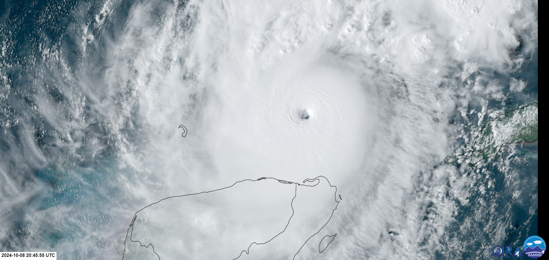
Maximum sustained winds are in a small area near the center as strong as 165 mph now. Hurricane-force winds extend out 30 miles from the center, and tropical storm force winds extend out 140 miles. This is now about 33 percent larger in size than it was this morning and 75 percent larger than yesterday. This was why we were concerned. Milton is now a formidable storm in terms of size as well. And it will grow further before landfall tomorrow night.
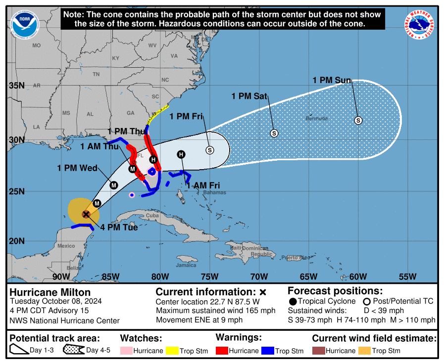
There was potentially (and I say potentially VERY cautiously here) good news for Tampa Bay today. Milton wobbled off track some to the southeast. This has now shifted the track guidance somewhat to the south. While this may be good news for Tampa ultimately, it is not good news for places like Sarasota or Venice or possibly Charlotte Harbor. Those areas may now be closer to maximum storm surge. Charlotte Harbor for instance has seen its maximum potential storm surge increase from 6 to 10 to 8 to 12 feet. This is now at Ian levels in some spots there. Surge of 8 to 12 feet is now also expected as far south as Bonita Beach. This is shy of Ian levels, but it’s getting a little more uncomfortable.
If you live south of Venice and north of Naples, have yourself ready to bolt tomorrow morning toward Miami if this thing keeps nudging southward. It is getting a bit more uncomfortably close than hoped.
For Tampa, you just need to watch and hope for the best now. It remains entirely possible that Milton comes back north some, in which case a Tampa Bay landfall and catastrophic surge is even more in play. It’s just simply too close for comfort still.
For everyone on the Florida west coast south of Clearwater, this will be a pretty rough storm in terms of wind and surge. If you have not evacuated and are in a zone ordered to do so, please reconsider, and please check on anyone who may not be able to evacuate or is being stubborn about it. Surge is the deadliest concern. In most cases, hiding from the wind will be the best course of action elsewhere.
Hurricane warnings have been expanded today to include all of St. Lucie County. Hurricane watches have been hoisted southward to the Palm Beach County line. Tropical storm warnings now include the Bahamas, all of South Florida, and much of the Georgia coast. Storm surge warnings have also been expanded accordingly, and there’s now the expectation of a 3 to 5 foot surge from Sebastian Inlet north to near Jacksonville. If Milton’s track slips farther south, this surge would also slip farther south, so folks from Palm Beach County up through St. Lucie County should be monitoring trends closely.
We get a lot of questions about wind risk for XYZ. Consider this map (which you can enlarge) a reasonable worst case scenario for what peak winds could be at a given location.
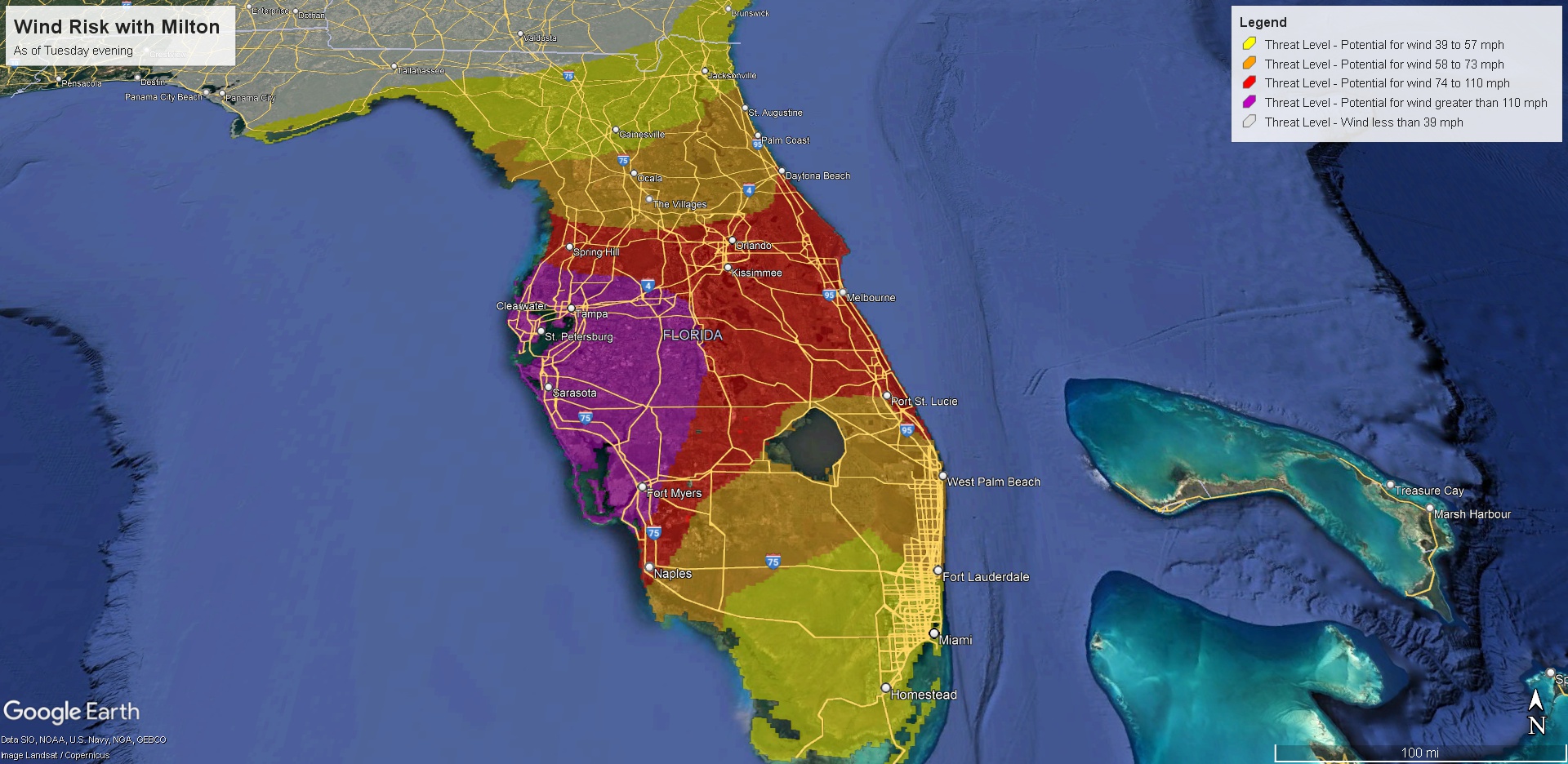
The south side of the storm will be primarily surge and some wind. The north side of the storm will be wind, some surge, and torrential rainfall. A high risk of flooding continues to be in effect tomorrow in Florida along and north of I-4.
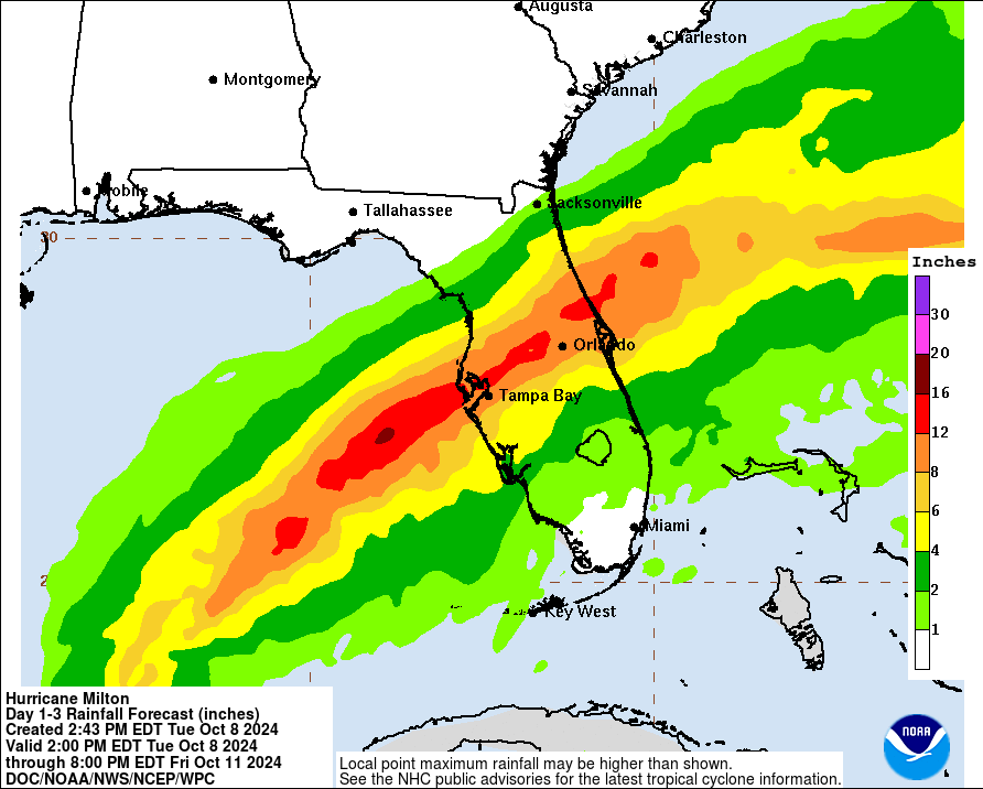
This has slipped a bit south since this morning also, and now the heaviest rain risks align with the I-4 corridor almost perfectly. Any further southward adjustment will take the heavy rain farther south also.
And of course, isolated tornadoes are always possible with storms of this size and intensity.
The bottom line: A complex, multi-hazard storm is headed to Florida. It will impact the west coast hardest but it won’t spare the east coast entirely. The biggest concern is storm surge, which is likely to be worst between Sarasota and Fort Myers. For areas south it’s still shy of Ian levels, but it’s nudging ever closer. For areas between Sarasota and Cape Coral, it will likely be worse than Ian. Again, this is a dangerous, historic storm, and it’s one that you should not stick around to observe and ride out if that’s possible. We will update again tomorrow morning or late tonight if the track shifts significantly.
Matt, what level of storm surge is most likely for the Tampa area on the current track?
33% bigger. Ugh
Eyewall replacements.. no bueno.
💙🙏🏻💙 for Florida
I have family in st Augustine area (ponte vedra) and Port Saint Lucie. No evac zones so staying out. Sick with worry for them
Put*
Any advice for the middle part of Florida, like Orlando?
Shelter in place in a sturdy building.
We evacuated from Venice this morning and the track updates have been very depressing. After riding out the never ending Ian a couple of years ago I’m glad we left for this one.
Just not sure what will be left when we get back
You’re strong, Jordan – you’re going to make it through this, I promise 🍂🧡🍂
I have read multiple references to the storm potentially weakening before it lands. Potentially a Cat 3? Is that still a possibility? Very much appreciate your expertise and insight.
Thanks
A
Andrew: Yes, still a possibility as Milton is expected to encounter wind shear as it approaches the West Coast of Florida, but the weakening will not affect the storm surge much. It’s still going to be bad right around where it hits land. Tampa could be spared the very worst of it now that there has been a slight jog to the south, dependent on whether or not there’s any more eye wobbling.
Sad to watch the Fox 24 Hour Weather channel. They have meteorologists on the streets all over FL … showing owners’ home possessions stacked up on the street.
We can relate – we had to empty all our home belongings along the street after Harvey dumped 5 foot water in our Cypress home.
The sad part for the FL folks is that Milton is gonna sweep up all the stacked up belongings and scatter it all over the affected towns. A shame there hasn’t been enough time to properly clean up the streets of the belongings.
Floridians can look at Flood Zone maps, basically past 20 miles from coast is not flood zone so unlikely to flood much, except Tampa Bay which has low land all around bay. If past 20 miles and not evacuating find a sturdy interior doorway and move upward only if water floods 1st floor, and absent tree falling thru house you’ll probably survive, 99.9999% past 20 miles just 1 chance in 100,000 past 20 miles.
Here’s what I think the difference might be with Milton … the prediction from many meteorologists is excessive rainfall. Doesn’t matter if 5 miles or 30 miles from coastline.
An example. Our Cypress home was over 60 miles from the coastline (i.e., Galveston). Harvey dumped over five foot of water onto that property, along with many other families around us, and for thousands around the overall Houston area. Harvey wasn’t necessarily a catastrophic hurricane in the traditional sense, it was a horrible rain dump.
We were 3x beyond this “20 mile zone”.
The best hope is Milton will zip over FL very fast into the Atlantic, so it does not spend much time dumping a lot of rain – even though it’s predicted, as they just mentioned (weather channel) a prediction of 12-18 inches of rainfall.
If your home is a one story, there’s no option to “move upward only if water floods 1st floor”. And NO, living in the attic isn’t wise 👍
Be smart and evacuate.
Run from water shelter from wind. I live just 30 miles from the coast and will never forget the rain sound of Harvey. The water had nowhere to drain. The water came within an inch of coming in my back patio door. We got lucky. Hoping that same luck holds for my brother in Dunellon.
Rain flooding inland is VERY unlikely to knock down a house or jam trees thru house, which can kill and come mostly from Ocean storm surge by the coast. So yes past 20 miles Floridians are fairly safe. People confuse medium risk to life with medium risk of harsh conditions for month, these are 2 different things. Even govt doesn’t tell people inland 20 miles to evac for safety, it’s weird for laymen to ignore the experts and tell everyone in FL to evac for safety. Orlando is safe, Tampa is not get out of Tampa. And there just is not room for 20 million to evac, better 2m evac than 20m, over-scaring seems nice but actually does harm. Or some evac expert can explain if I’m wrong, not just us laymen left to puzzle this out.
Was the landfall pressure captured for the Galveston hurricane of 1900? Comparing it to Milton. Prayers up for Floridians
Lowest recorded was 936
https://ncics.org/ibtracs/index.php?name=v04r00-1900239N15318