Headlines
- Milton is now a major hurricane, with further strengthening likely to high-end category 4 or category 5 intensity north of the Yucatan.
- Milton is expected to bring widespread, significant hurricane conditions to the west coast of Florida on Wednesday.
- Milton will have a significant storm surge, regardless of its landfall intensity, and west coast communities in the Tampa area and south should expect a Helene-type surge *at a minimum,* with higher surge likely at and south of the exact landfall point of Milton.
- Heavy rain will overtake most of north Florida Wednesday and flash flooding is likely along and north of I-4 then.
- Milton should accelerate out to sea after Wednesday night.
As of 7 AM ET, NOAA hurricane hunters discovered that Milton now has 120 mph maximum sustained winds and a pressure of 954 mb. Milton is undergoing rapid intensification in the Gulf and is now a major hurricane.
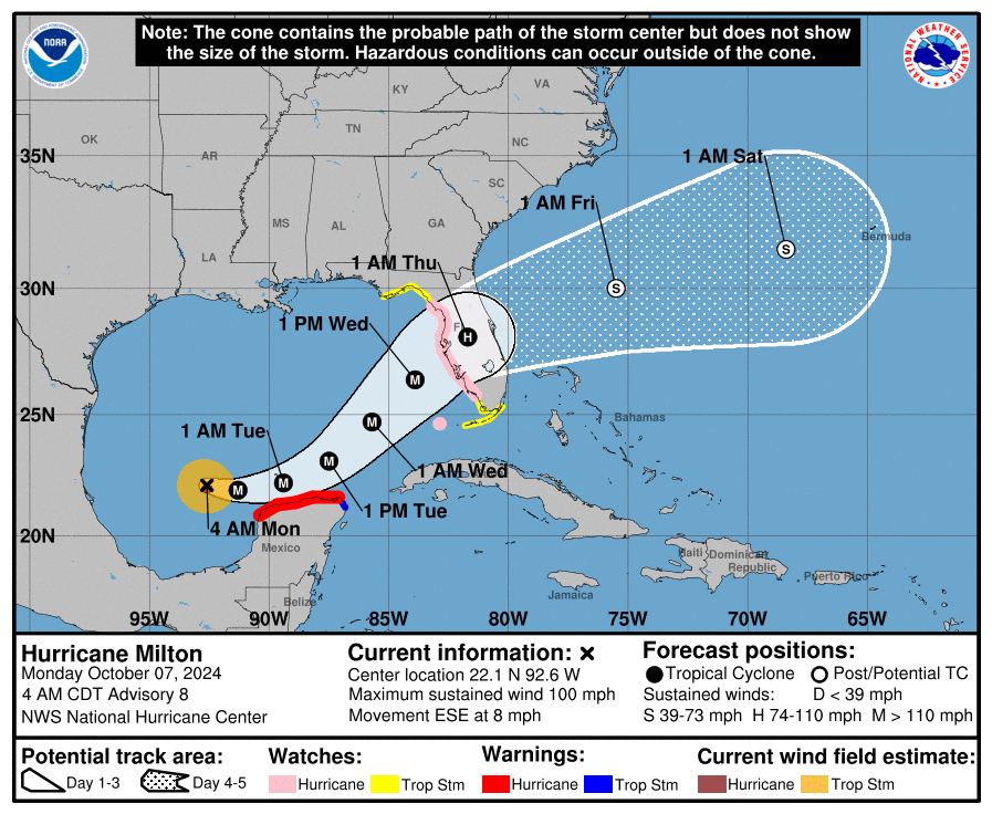
In the immediate term, hurricane conditions are likely on the coast of the Yucatan tonight and tomorrow morning as Milton passes. Warnings are posted from Celestun to Rio Lagartos in Mexico. This does not include Cancun or Cozumel.
There are several things to touch on this morning. We’re going to go over track, intensity, and surge in this post.
Milton’s Track
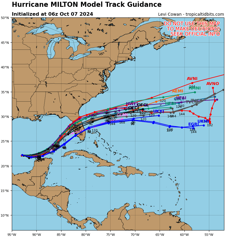
There are a couple elements to Milton’s track that are important. Milton has a little bit of north to south trajectory being imparted on its motion right now, and that’s why we’re seeing Milton track east-southeast. That component of the direction is expected to fade after today, and Milton will then basically rush off to join up with a trough in the upper atmosphere dropping down the East Coast. As this happens, Milton will turn east and then probably due northeast. While Milton is a rarity in terms of how far west in the Gulf it formed, what it’s doing in terms of track is fairly common behavior of Gulf storms in October.
For Florida, the question of track and trajectory is critically important. On one hand, there will be a large, major hurricane approaching the west coast of Florida on Wednesday afternoon. And from that point of view, expect widespread hurricane impacts regardless of track. On the other hand, as we’ve discussed, the exact track is critically important in terms of how storm surge will behave. The worst surge will come in at and south of where Milton comes ashore, so a track into Siesta Key has a drastically different outcome than a track into Clearwater. This isn’t just for Tampa; it’s for the entire heavily populated west coast. So we’ll need to see exactly where that turn to the northeast occurs and how strong Milton actually gets. But as noted yesterday, everyone on Florida’s west coast needs to prepare as if this is coming and follow the advice of local officials.
Milton’s intensity
Now that Milton is already a major hurricane, it seems likely that it will become at least a category 4, with a chance to become a category 5 storm.
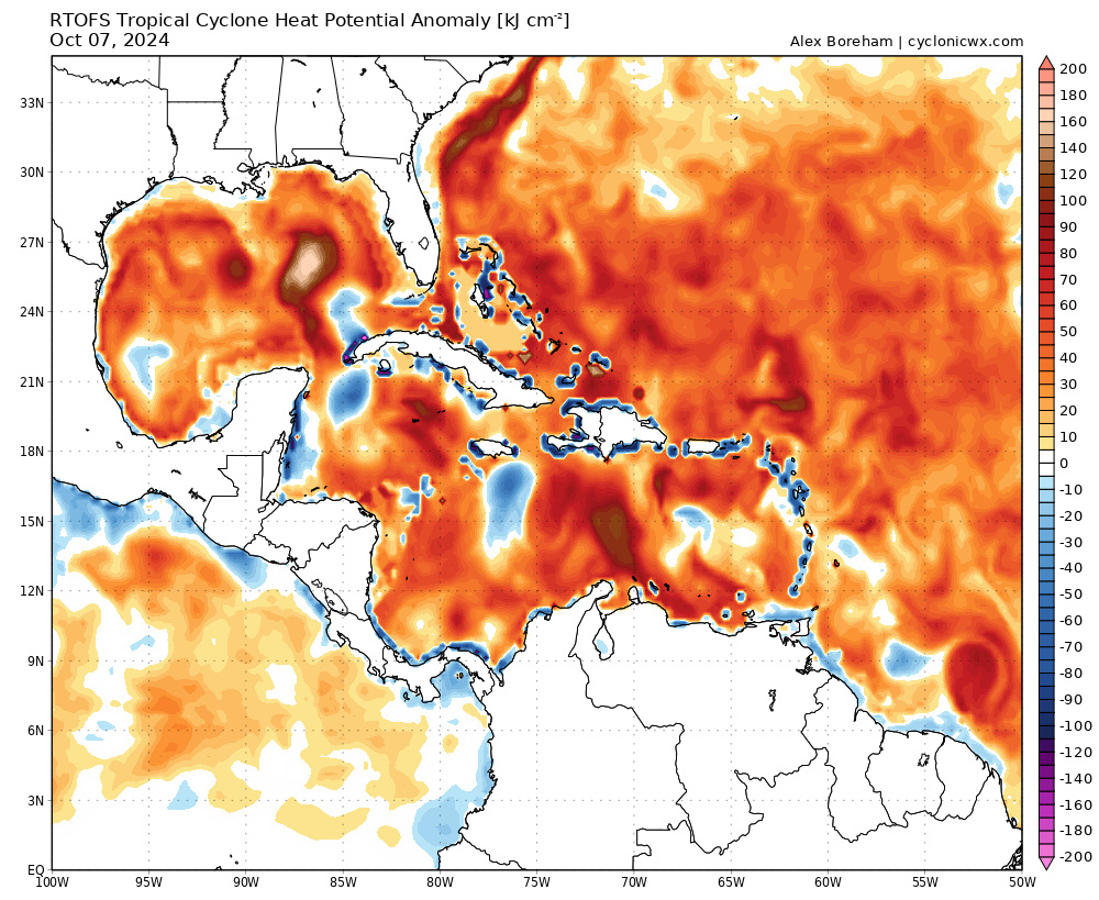
We can say that Milton has a reasonable chance to become a high-end 4 or 5 storm because of the heat potential available to it in the Gulf. All else aside, the storm will have some of the highest heat potential in the entire Atlantic, outside the northwest Caribbean available to it for intensification. Most modeling shows the storm peaking in intensity sometime tomorrow and then slowly shaving some of it off as it approaches landfall. Unfortunately, from a surge point of view this matters very little. The surge is baked in and even if the storm weakens substantially, the surge will lag that weakening. If, hypothetically, Milton becomes a cat 5 and makes landfall as a cat 3, it will probably still have surge equivalent to a strong cat 4 at landfall. So we have to assume the surge is going to be very bad regardless. In terms of wind, a storm that weakens will probably also expand in size. So while the peak wind may be lower at landfall, those winds will envelope more of the coast than otherwise, and the expectation should be that much of the west coast of Florida will be experiencing substantial hurricane impacts on Wednesday. Impacts to the east coast and inland Florida will be less severe than the west coast in terms of wind, but those areas will still likely see tropical storm or hurricane winds as well.
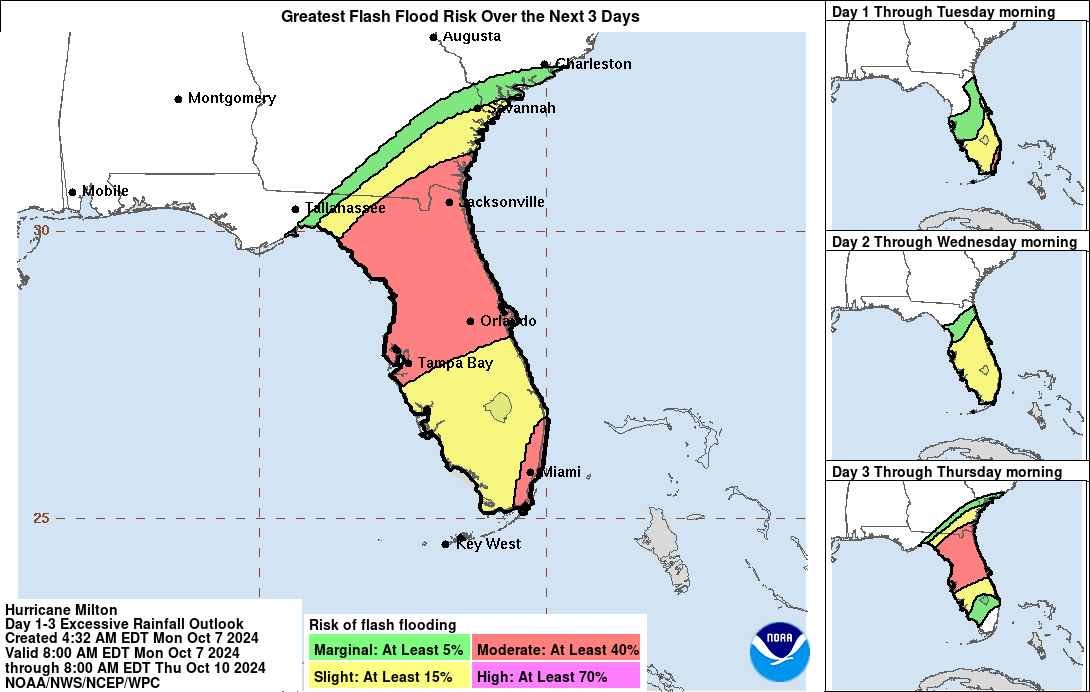
Flooding will be an issue regardless of Milton’s intensity, and the heaviest rain will fall along and north of Milton’s storm track from central Florida into portions of southeast Georgia.
Milton’s surge
By far the most troubling aspect of Milton will be the surge. Again, the fact that Milton will likely be past peak intensity when it makes landfall will matter very, very little in terms of what sort of storm surge it brings.
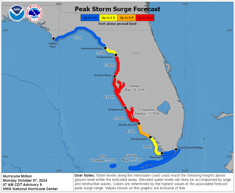
More critical for surge, as noted above will be where the storm makes landfall. I anticipate that the map above will evolve as the track becomes clearer. At this point, Tampa Bay should expect, at a minimum, a Helene-type surge. If Milton hits north of Tampa Bay, the surge will be several feet higher and possibly more forceful than Helene. Surge will also be notably worse than Helene for areas south of Tampa, including Sarasota, Fort Myers, Naples, etc. Exactly how much worse will depend on track. But surge is probably going to be the most dangerous, concerning element of Milton. That will be what determines evacuation orders. And again, we can’t stress enough that you should heed those warnings and hope for the best.
We’ll have another update following later this afternoon once we digest the 5 PM ET advisory.
Hi Matt and Eric,
How is the loop current factoring into intensification for Milton, or is it? Did it factor into Helene?
Loop current is much warmer water to help rapid intensification. Its area Helene started to RI during trek to FL
The loop current factored in more for Helene as it runs more a N/S trajectory, so Helene traveled up it.
Milton will cross over it horizontally, so less time over it.
Why doesn’t the NOAA Static Images map indicate a hurricane warning on the east coast of the Florida peninsula?
Because there is not currently one in effect.
Thanks for this update. Praying for Florida.
Do you know how long is that CAG going to be down there?
That’s what I’ve been wondering..I tried to run tropical tidbits for noon, it keeps crashing..From what I saw, GFS shows yet again, disturbed weather in the southern gulf, possibly forming behind Milton..
Me too – it keeps spinning off trouble
That damn thing is 150 mph now 😱
Viv: It’s up to 155 mph now.
Richard: It’s now a Category 5 with winds up to 160mph.
Sheltering: I was afraid of this, and expecting it. As soon as it entered the Gulf it kicked into gear extremely quickly.
175 mph now
I don’t think the Atlantic has had a storm this strong since 2019.
I fear Tampa’s lucky streak is in serious danger. At least people have 2 day’s warning-please take full advantage of it!
Did the hurricane hunters really just see a 175 kt surface wind, or was that a radar glitch?
Now 160 mph !
Pressure is at 925 mb and falling. Additional strengthening possible.
Craig: That drop has been dramatic!
Hello!
Based on the information you have: any thoughts or elaboration on the upcoming impact to the Yucatán, specifically Merida which is 15 km off the coast?
How intense will the winds be based on the expected trajectory of the eye?
Thanks!
When you said 15km “off the coast” I was picturing an island that would be absolutely swallowed by the storm. Glad to google and find out you mean inland from the coast.
Now 175 mph.
Right now, Milton is outside of the NHC’s cone from 24 hours ago (It is south of the cone from yesterday). I have not heard much about this less-than-24-hour forecast error. Maybe they need to make the cone wider.
Interesting observation. Yet the predicted landfall location seems fixed throughout the graphical forecast history. I wonder if a surprise is in store for folks.
911 mb.