Headlines
- Milton is now a hurricane, and it is forecast to become a powerful category 4 hurricane over the Gulf of Mexico.
- It continues to look likely to track into the west coast of Florida on Wednesday as a major hurricane, delivering wind, rain, and potentially catastrophic storm surge to Florida’s west coast.
- Impacts will be significant regardless of Milton’s specific intensity at landfall.
- Milton will also deliver some impacts to the north coast of the Yucatan tomorrow.
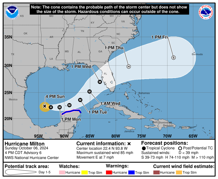
Hurricane Milton is strengthening this evening, now with winds of 85 mph. It is expected to become a category 4 hurricane now with 145 mph maximum sustained winds by Tuesday afternoon. It will likely peak in intensity and come ashore into Florida in a somewhat less intense state, however a no less dangerous one.
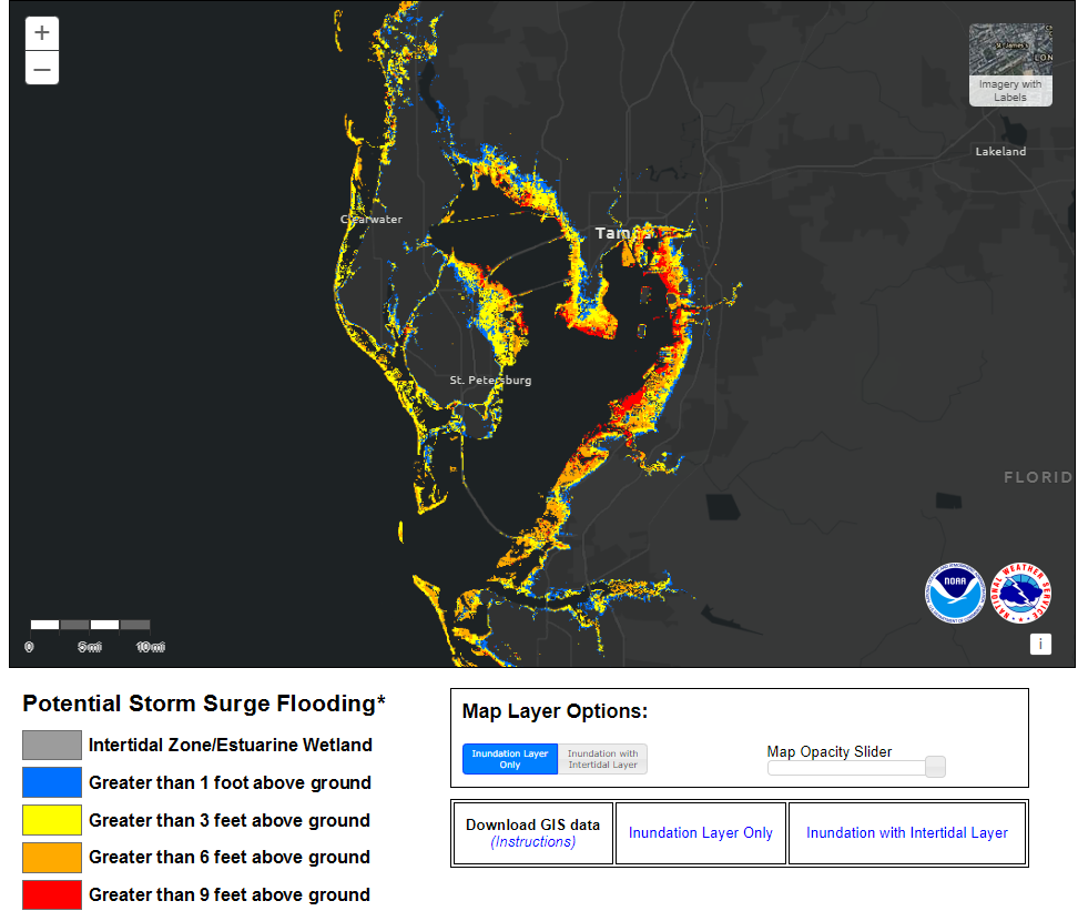
First point I want to absolutely stress: Given that this storm is going to be extraordinarily precarious for the Tampa Bay area, if you live in an evacuation zone on the Bay and you are told to go and you have the means and ability…go. If you do not, follow up with local officials on what you need to be doing. This is the storm where you expect the worst and hope for the best. Tampa’s had a generally favorable hurricane history over the last 100 years, but at some point that streak is going to end. Unfortunately, you are not afforded the luxury of time with this one. A track north of Tampa Bay has dramatically different impacts in terms of surge compared to a storm tracking south of the bay. As local WFLA meteorologist Jeff Beradelli stressed yesterday, you run from the water and hide from the wind. You don’t need to travel hundreds of miles to escape the surge threat; just a few. But if you are told to go, you should go out of an abundance of caution. We will debate the specifics of the forecast, but I want to remind you that notable past storms such as Katrina, Rita, Ike, and Opal were all storms that were weakening at landfall and that all did tremendous surge damage. That’s the fear in Tampa Bay.
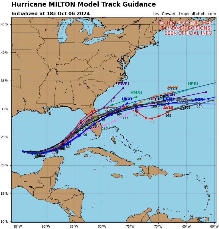
Current model forecasts are still spread out to a point where we believe there are almost equal chances that this tracks just north or to the south of Tampa Bay. In other words, we are still waiting on some clarity with track, hence why we are advising people to evacuate if told to do so.
We are obviously heavily focused on Tampa because that’s the densest and most populated area in this region. But let’s talk briefly about a few other places.
Big Bend & Nature Coast: Areas that were hardest hit by Helene last month will likely see impacts from Milton but hopefully mainly via rain and some gusty winds. With the storm currently likely to track to the south and an offshore wind in place, Big Bend communities should be spared additional surge problems. But some added vulnerability from Helene may lead to a few issues. Follow the advice of local authorities.
Sarasota & Bradenton: Wind and surge will be major concerns here. Unless this does follow extreme southern model forecasts and comes in near Fort Myers, there will likely be a substantial surge in these areas. While there will be strong, potentially major hurricane force winds here, the strongest winds may end up north of this area. Much like Tampa, however, it would be wise to follow any evacuation orders given and you should take this as seriously as Tampa.
Fort Myers & Naples: Obviously this region is vulnerable and on edge for any storm impacts given Ian’s hit a couple years ago. You’ll want to watch how close this gets to you in terms of how much wind to expect (the closer, the worse). Surge should be considerable no matter the track at this point, and you should be following the advice of local officials who should know the risks of surge post-Ian. Really want to make sure folks here take this seriously.
Orlando: We’ve gotten a lot of questions about the Orlando area and people with vacations. In Orlando, the impacts from Milton will involve wind and rain and the potential for severe weather. There will be areas of flooding in and around Central Florida, especially given precursor rounds of rain. So obviously watch for that. While the wind will probably be nasty at times and power outages will be a good possibility, most hotels should have plans in place to keep guests safe in storms like this. One other risk in interior Florida will be that of tornadoes or severe storms as Milton blows through.
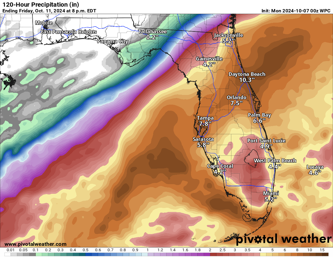
Daytona through Jacksonville: This area will see very heavy rain, possibly back inland to Gainesville as well. In addition to tropical storm or hurricane conditions as Milton crosses the area, flooding and isolated tornadoes will be possible. There will probably be some minor storm surge as well on the east coast of Florida.
In terms of rainfall for Florida, between predecessor rains and Milton, we are looking at 5 to 10 inches of additional rainfall along and north of I-4 in Florida.
So the message I want to close with for now is this: This is a serious, serious threat to Florida and it should be taken seriously. Don’t let any conversation among meteorologists or others about what intensity Milton will be at landfall dictate your decision-making. Follow the advice of local officials, check on friends, family, and neighbors. Prepare for the worst and hope for the best. We’ll post again in the morning.
Excellent reporting. Thank you.
“… if you live in an evacuation zone on the Bay and you are told to go and you have the means and ability.”
Some of the saddest stories I’ve read of Helene’s carnage in Western NC are those of people who were offered a ride out from rescue crews before the worst of the floods hit, opted to stay, and paid with their lives. I hope everyone is going to take this seriously.
I appreciate how good prediction has become, wow, for TX to not fear a storm in West Gulf is a quiet miracle of science, wow. When acting people do have to consider resources, consider 1 in X risk of death, consider likelier week of discomfort during recovery, it’s complex. Those who rely on transit no car to evac are in trouble I guess.