In brief: The Davenport, Iowa area dealt with some serious flooding last night. Today’s risk shifts back to Texas, Oklahoma, and New Mexico. The tropics remain quiet, but Florida should see a fair bit of rain next week as a tropical disturbance emerges in the Gulf. And we’ve got some good articles to share on the complexities involved in the Texas flooding tragedy.
Davenport flooding
The latest in an absolute spate of flash flood emergencies occurred yesterday in Davenport, Iowa. This was caused by a line of slow-moving thunderstorms that dumped 2 to 4 inches on the Iowa side of the Quad Cities. This brought totals for the day up to about 5 inches in spots.
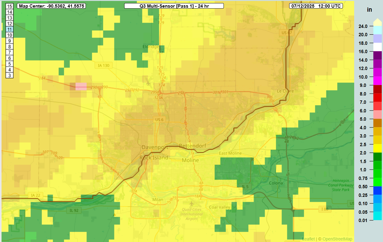
Numerous instances of cars submerged in water and even some structures flooding occurred with the storms. Precipitable water, or how much moisture is actually available in the atmosphere was rather high across the Midwest yesterday evening, as shown from the European model’s output yesterday.
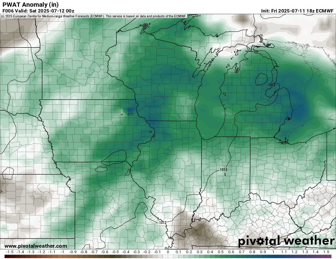
Officially, south of Davenport, the near upper air sounding in Lincoln, Illinois showed a PWAT of 1.77 inches, which is in the 90th percentile of days. For Davenport, those PWATS were probably closer to the 95th percentile. In other words, another day of some ultra rich moisture that the atmosphere tapped into and produced damaging flooding. Models did an ok job on this event, though the HRRR misplaced the bullseye too far northwest, whereas the HREF model was a little too aggressive and to the east.
For those keeping track, this was the 12th reported flash flood emergency this month across the country. Most obviously occurred in Texas, but there have also been emergencies reported in New Mexico, Pennsylvania, and in Iowa (and Illinois).
Texas, Oklahoma, and New Mexico flooding chances
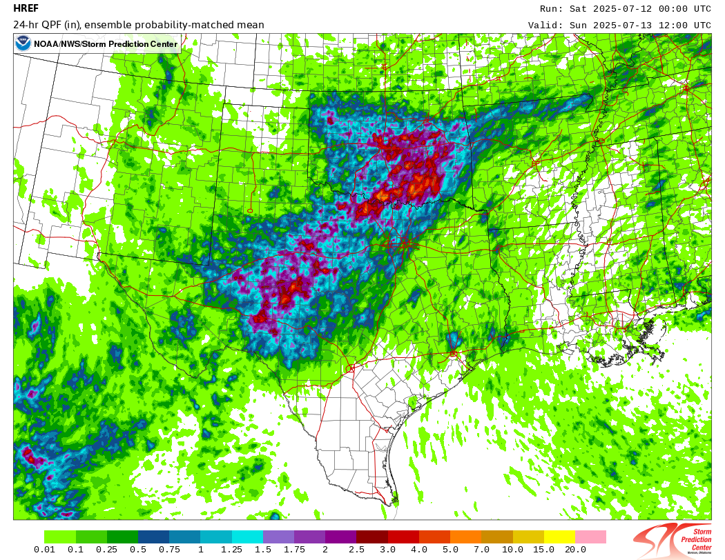
Next, we focus back on Texas and the southern Plains. Another round of scattered storms may produce locally heavy rainfall today, including for Hill Country. The area is highlighted in a slight risk (2/4) of flooding rains today. This also includes much of Oklahoma and for the burn scars in New Mexico, including Ruidoso.
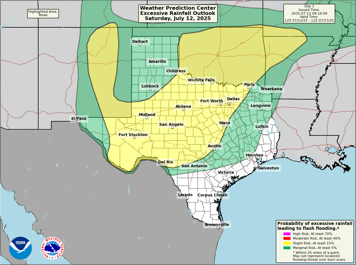
Anywhere from 1 to 3 inches is possible through today, with localized “lollipop” totals of 3 to 6 inches in any given location also possible. The focus of the highest chances of those higher totals occurring seems to be in Oklahoma and north of DFW Metroplex today. However, chances are not zero between Abilene, San Angelo, and areas west of Kerrville.
Hopefully in any of today’s cases, flooding will be of the sub-emergency sort. The Ruidoso area doesn’t stand out in the modeling today, but given the ultra-high sensitivity of soil there, it would not take much to trigger flash flooding.
Tropics
While the Atlantic is forecast to remain quiet over the next week, I would not be shocked to see a risk area drawn over the northeast Gulf at some point this weekend. Chances are probably 10 percent right now, if that, but there’s enough noise there to at least watch for the potential of a low-end system.
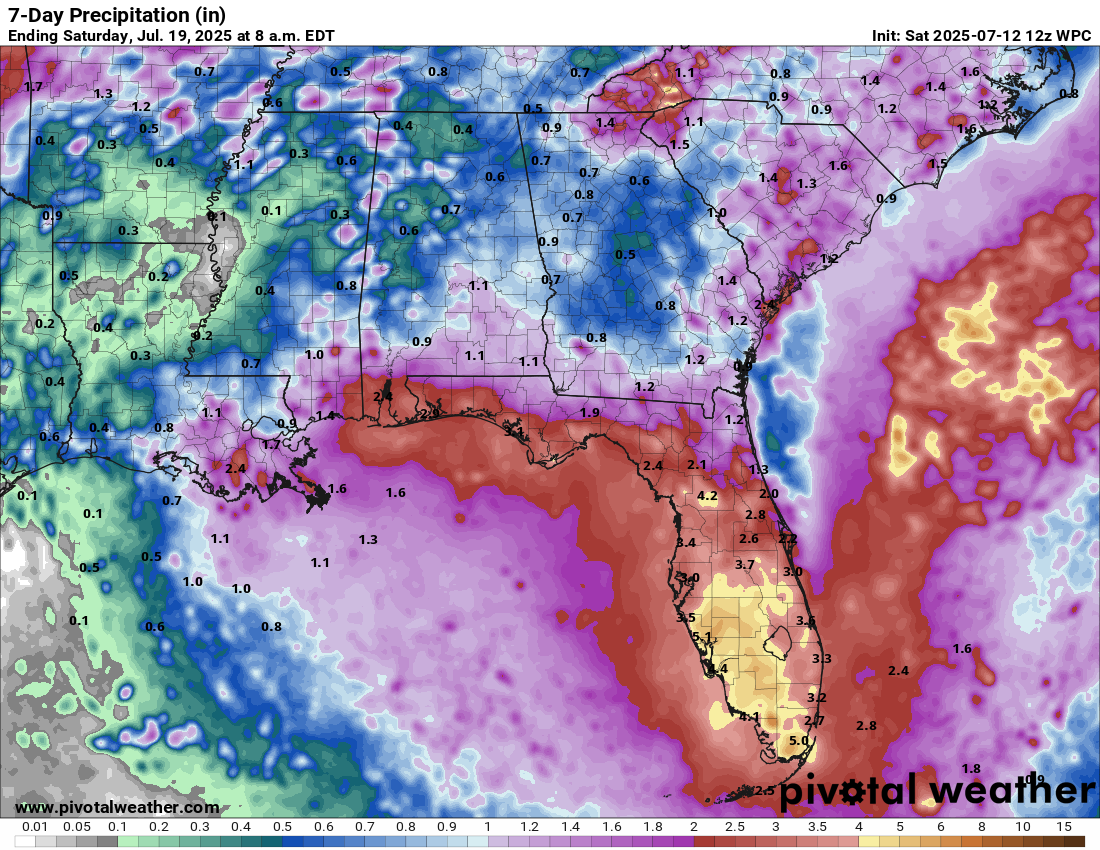
Rain totals of 2 to 5 inches are forecast for the Florida Peninsula and Panhandle coast, back into Mississippi and Alabama. Some localized flooding is possible, but obviously we’ll continue to keep tabs on the potential for anything more organized off the coast here.
More questions in the wake of Texas flooding
I don’t have a lot to write about here today, but I do want to point you to a couple notable articles this morning. To get a good perspective on what went wrong in Texas, the emergency management piece is absolutely critical to understand. Most people know emergency management exists. Many people don’t know what it does. Everyone, however, has an opinion of FEMA it seems.
First, read this excellent article about the warning timeline and the emergency management relationship and response from my colleague and friend Alan Gerard who writes the excellent Balanced Weather Substack.
Then, read his follow up piece here.
This stuff is complicated. It’s never a black and white issue, and the gray area is gigantic and broken into various shades of gray. But I feel like Alan’s posts there give you a good understanding of the interplay between emergency managers and the weather. Alan is a former NOAA/NWS employee who knows more than his share of how the two disciplines engage operationally.
Lastly, Chron.com in Houston published an excellent piece about the debate that occurred in Kerr County back in 2021. Monday morning quarterbacking is easy, but this raises serious, serious questions about what happens when you politicize to an extreme level certain elements of disaster and mitigation. It’s a cautionary tale that a number of vulnerable communities engaged in pre-2025. I’ve learned a lot about disasters as a meteorologist, and to me it makes absolutely no sense to reject federal money for disaster mitigation projects in a world where disasters are becoming more common. That money will go elsewhere instead. Hyper-politicization can literally harm communities. It’s time to start looking at this stuff more clear-eyed.
We will probably take tomorrow off and come back with a fresh post Monday. Thanks again to all our subscribers, new and old. It helps continue to propel us forward and upwards.
What does next week’s tropical potential in the eastern Gulf mean for Houston?
I second this – I read that there could be two (I think it was two) stalled fronts, leaving an unorganized system to rain a lot in the NE Gulf, then meander/drift west towards Hou/Gal/Beaumont bc it keeps getting pushed back over the Gulf.
(That’s my Dummy Version of what I believe I read…)
I’m just concerned about a lingering, long-term rain event over us.
(I hope I misunderstood what I read…)
Well, just checked the NHC 7 Daily Atlantic graphic – Disturbance One posted at 12.30.
20% chance over 7 days
0% for 2 days.
The yellow blob is in the South-eastern Gulf, stretching from LA to FL and partially in the Atlantic side of FL.
Well at 9.04pm Sat, the Disturbance One yellow blob has now shifted to the west in the Gulf … so none of it is on the east side of FL.
The western edge of the blob has inched closer to TX. , so it seems it’s moving westward.
It’s still 20% for 7 days, 0% for 2 days.
Again, there is absolutely nothing inappropriate about refusing to take federal money. It is not “extreme” politicization.
They did end up taking it though. And used it not for installing sirens, but adding more positions in government, and salary increases, ect. The money was there for them to use for a purpose they knew they needed, but because they were convinced taking “Biden” money would cause some detriment to them, they didn’t use it in the best interest of their community. Vilifying the opposing party to such a degree that you don’t help your own community is the definition of politicization.