Headlines
- Model support for development in the Caribbean or near the Yucatan is increasing next week with development likely to begin after this weekend.
- Models continue to disagree significantly on track outcomes and intensity outcomes, not to mention timing outcomes with weak solutions, strong solutions, late week solutions and next week solutions all on the table.
- We explain below why Texas is not currently favored but should still at least keep tabs on things.
- No other significant tropical concerns exist beyond this feature.
Honing in on Caribbean possibilities
Apologies for the late post today. As many of you are well aware, Eric and I both have day jobs which occasionally do have to take priority! The good news is that not a whole lot changed between late morning or afternoon and this evening, which is to be expected when a storm is about a week or more out.
Yesterday, I noted how modeling did not exactly seem helpful at this point because there had been much bouncing around, little strong ensemble signal, and no one model being more consistent than others. Today, let’s re-evaluate things and also take a look at the upper air pattern that may be in place around the time this system develops in the Caribbean. First, I also noted yesterday that the NHC tends to be conservative with development odds this early in the game, and the 20 percent was probably a little low in reality. Well, they’ve doubled those odds today, and we’re now at 40 percent.
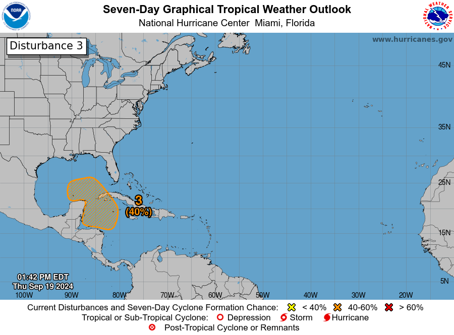
The Hurricane Center has to do things fairly by the book, which is understandable. The biggest reason I think their odds are not higher is because we’re talking “over the next seven days.” If it were over the next 10 days, I might say this would be up and over 50 percent. Either way, we’re kind of getting way too in the weeds of nuance: The takeaway is that development odds are elevated and continue to increase.
We still don’t have a disturbance to latch onto. We tend to take this for granted sometimes. Weather models are literally sniffing out a disturbance that has not even formed yet and sending up caution signals that something will form, and they’ve been doing it for days. That’s pretty wild. Anyway, all we have is an area of disorganized thunderstorms in the eastern Pacific and near Panama.
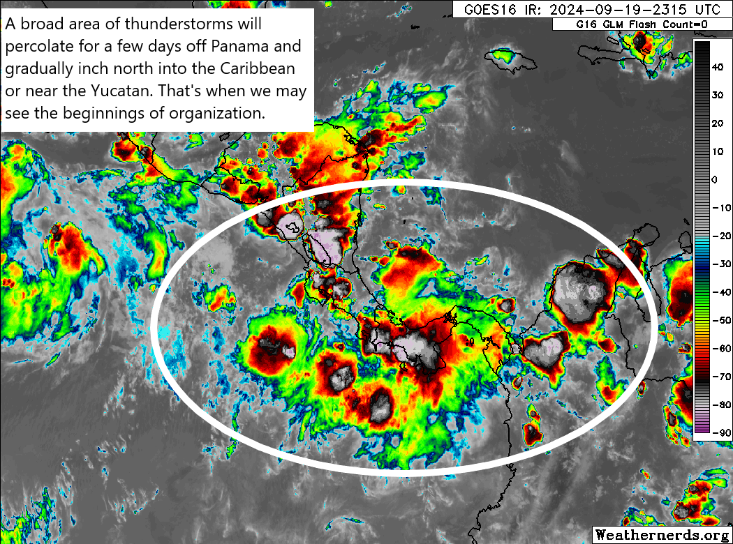
Over the next few days, we’ll probably see this mass of thunderstorms wax and wane but generally persist in this area. It will gradually ooze northward into the weekend before any sort of attempt at consolidation occurs. When and where that happens is critically important for the future of this system. If those storms end up a bit west and more focused near the Yucatan, then development will struggle to occur. If that occurs a bit east, more into the very warm waters of the northwest Caribbean, then development and organization may begin to occur more rapidly next week.
The problem with these gyre-type systems is that modeling struggles in telling us where that consolidation will occur. For example, the 12z European model today takes the western track of things and basically buries this over the Yucatan or Bay of Campeche for a few days before eventually blowing it up over the western Gulf. The GFS on the other hand does this closer to the northwest Caribbean, which leads to a stronger storm quicker and a more eastward leaning track into Florida.
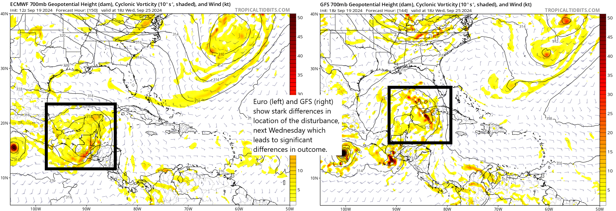
For those curious about such things, the ICON model leans toward the European model, while the ECMWF AI model, the AIFS is more apt to split the difference between the two possibilities. We can get a sense of timing with this now too. The faster GFS brings this across Florida next Thursday/Friday, while the Euro keeps this sitting in the western Gulf through at least next weekend. So not only do we have limited track confidence, we also have limited timing confidence.
Sidebar: If you are planning a trip to the Caribbean next week or weekend, I cannot tell you what to expect right now. You will need to monitor the forecast, stay in touch with your hotel or cruise line, and just be prepared for some disruption potentially. Everyone has unique circumstances and we just can’t get to every trip question.
Anyway, let’s take a quick look at the ensemble guidance from earlier today. The European ensemble shows nicely what I explained above. A bunch of the 51 ensemble members follow the operational Euro and keep this buried in the Bay of Campeche, while a minority are more GFS-like and go toward Florida or the eastern or central Gulf.
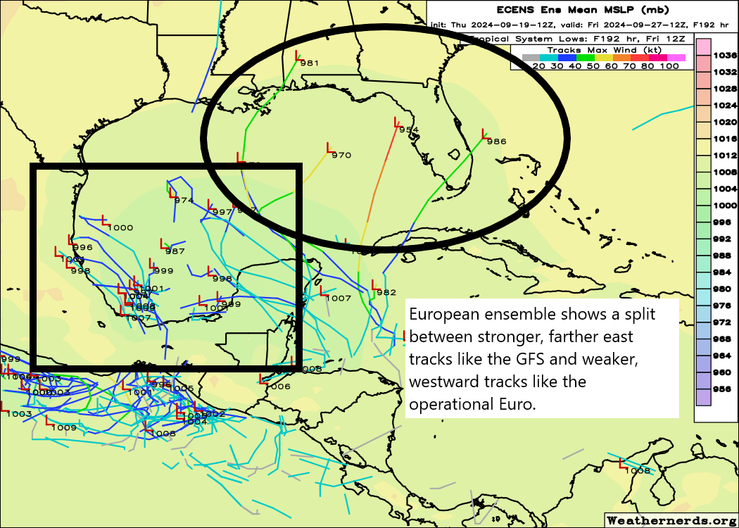
So, there remains significant spread in possibilities with this system and no one should ignore it on the Gulf Coast for now. But any land impact should not occur before next Thursday, outside of perhaps the Yucatan or Cuba.
Bottom line: Interests along the Gulf Coast should continue to monitor the progress of this system as it evolves over the next week.
The Texas angle on all this
With so many readers in Texas, I just want to jump in here and explain why I think we should continue to watch this storm — but should not lose sleep over it. The other aspect of this setup that will be critical to where it goes is how strong and deep troughing over the Eastern U.S. gets. A deeper trough means a stronger push of cooler air and a much easier scenario to “capture” the storm. The GFS shows this rather progressive pattern outcome. The Euro does too to some extent, but because the storm is weak and over the Yucatan it gets left behind and has to wait for the next one.
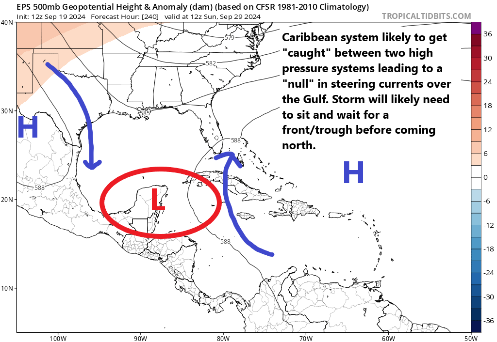
You can see this on the Euro ensemble panel from day 10 above, next weekend. High pressure over west Texas and the Southwest will impart a north to south component to the steering currents, while high pressure to the east of the system will impart a south to north component. This effectively cancels out any real storm motion, and it will probably be at the whim of whatever comes through the Eastern U.S. or it has to wait for that pattern to change.
So if you live in Texas and you look at the Euro and the ICON model and see this thing inching west or northwest, it would be natural to start to panic. However, when you look at the bigger picture, the sense I have right now is that this is going to take a hard right turn before it would get to Texas. Of course, that’s not great news in Louisiana or the eastern Gulf through Florida. So, yes, we should continue to watch this for changes, but the upper pattern supports a slow movement until an upper level trough can grab this thing and whisk it northeast.
Bottom line: Keep watching in Texas but there’s some meteorological support to believe this isn’t our storm.
Elsewhere
The remnants of Gordon have a 30 percent chance to develop over the next week. Another disturbance to the east of there also does, but neither is a threat to land.
There is growing model support for an African wave to develop near the Cabo Verde Islands next weekend, but it too seems destined to go out to sea. Right now, almost all our attention is fixated on the Caribbean.
Just like the models, Ventusky has been all over the place. Tuesday it was a system into the Florida panhandle, on Wednesday it was the central Louisiana coast. This morning it was back to the Florida panhandle and just now there is nothing at all through 10/3. It’s just too early.
Ventusky is actually using raw model data I believe. So you’re getting basically the same thing.
I saw on modeling at one point today that there was going to be a gulf disturbance coming in right behind the one we are watching, and be headed for the same general area..Please tell me I’m wrong in what I saw…
I believe one model shows that but not all. Doesn’t seem to have a ton of other support either.
Thank you for letting me know that you saw this on the models too, so I know that I’m not hallucinating, lol…
Im scared!! Plz let’s get the cold fronts so hurricane season can finally end!!
Yeah, I’m scared too, I don’t like this at all
Thank you for the update especially since you did work all day. Appreciate it greatly .
So when does the Houston hurricane season end?
Couple questions. 1) Is the capture scenario good for Houston? 2) where you describe it starting north but then turning right, what would cause this turn?
1.) Yes, it would keep it to our east. 2.) The trough that “captures” it would force it to go N then NE.
This is a great update & valuable information that helps towards understanding this scary stuff – so appreciated!
⚘
So, interestingly enough the National hurricane center has nothing on this thing…