Headlines
- Invest 95L is slowly organizing in the central Atlantic.
- There is strong model support for it to organize over the next 3 to 5 days.
- Models differ significantly on how quickly that occurs, which has important ramifications for the longer-term outlook on 95L.
- For now, Caribbean islands should monitor 95L closely as it organizes and prepare to put plans into action if need be, while those farther west and north should continue to check in every day or two for an update.
- Invest 94L and a Central American gyre circulation will provide heavy rain for Mexico and Central America over the next week.
Invest 95L will be giving us headaches over the next 7 to 10 days
We’ll get to Invest 94L in a moment, but first and foremost, if you utilize social media or are weather savvy, you’ve more than likely seen some of the model solutions from deterministic models for Invest 95L, which was minted yesterday from the tropical wave in the central Atlantic. Here it is this afternoon:
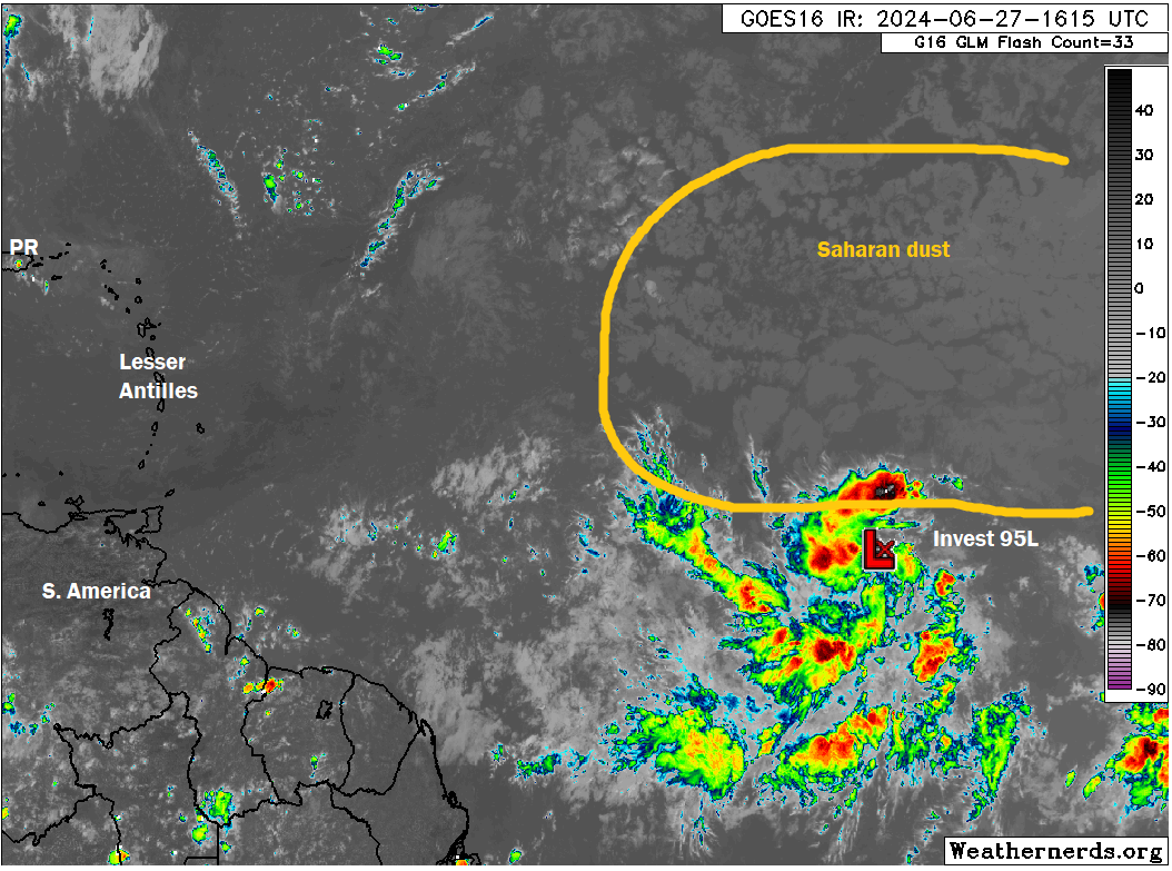
It’s respectable. This, to me, looks more like what you’d see in the central Atlantic in August, not late June. So this feels rather bizarre. As we noted yesterday, storms in June are not unprecedented this far east, but they’re still fairly rare. So Invest 95L is humming, and it will be a good idea to monitor this.
One thing we strongly advise against this time of year is monitoring deterministic models too closely: the operational GFS, the operational ECMWF (Euro), etc. These are one-solution, one-forecast outcomes. They have inherent biases in certain situations. For example, the GFS tends to be overeager with Atlantic wave development in systems like 95L. So it wasn’t exactly a surprise to see it barreling a hurricane into the Gulf or toward Florida on a couple recent runs. The Euro has its own struggles, and it too can be prone to errors in track or intensity. But these models swing around a lot from run to run. For example, the last five runs of the GFS have shown multiple possibilities.
12z Wednesday: Southern Caribbean to Hispaniola
18z Wednesday: Yucatan to Mainland Mexico
00z Thursday: Jamaica to Yucatan to northern Mexico
06z Thursday: Haiti to Cuba to Houston
12z Thursday: South of Hispaniola, between Jamaica and Cuba, to Cancun to the Rio Grande
Intensities have fluctuated all over on each of these runs as well. So, we’re not telling you not to look at deterministic modeling. We don’t want to be condescending! But do not use them as planning tools or even as a barometer of what is most likely. Often, the deterministic modeling ends up on one extreme of the ensemble envelope, meaning it’s arguably the least likely outcome! This is why we use ensemble modeling. It gives us a breadth of outcomes and risks. And we can dig into it to pull some signal from the noise.
In this case, the European ensemble actually does a very good job of offering up just that. I don’t like sharing spaghetti plots, because they are often too difficult to understand, but in some cases, they’re extremely useful. I believe this is one of those cases. Here’s the 00z Euro ensemble spaghetti plot for 95L.
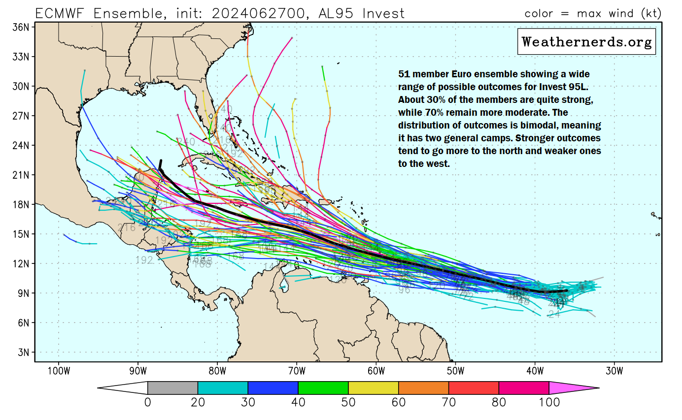
What can we take from this? First, there is a very bimodal distribution of the members. In other words, there is one cluster that favors a westward or slightly north of west track all the way into Central America or Mexico. A second camp exists pulling 95L more to the north, even as far east as near Bermuda! This makes intuitive sense, and it gives us a guidepost to consider when thinking about 95L’s future. In addition to steering currents and such, one factor that will determine 95L’s future will be its own intensity. A storm that strengthens quickly will be more apt to gain latitude faster, meaning a track in the right half of the ensemble envelope. A storm that struggles to organize longer will stay at a relatively far south latitude longer, perhaps even grazing the coast of South America.
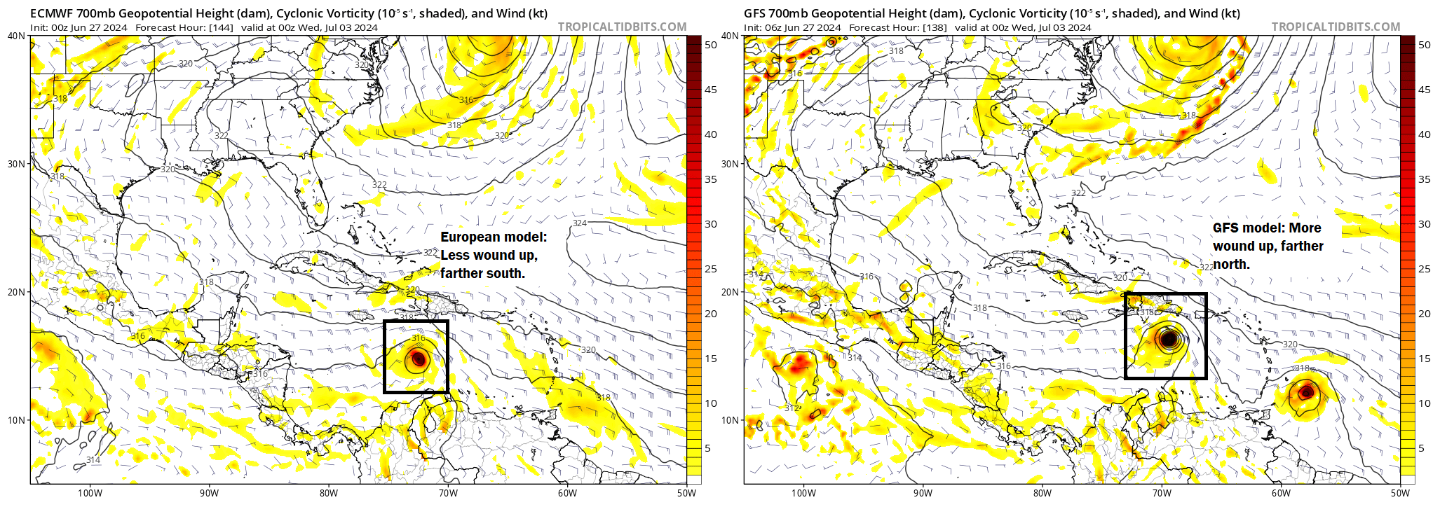
Here’s a good way to actually use deterministic modeling to your benefit. If we look at the comparison of where 95L will be on Tuesday, you can see the GFS is farther north than the Euro. This should not come as a surprise, as it is much faster to develop and wind up 95L than the Euro.
From a practical point of view, this means that what happens over the next 3 to 5 days with Invest 95L will be fairly important. If it forms quickly, it could come farther north ultimately. If it is sluggish to organize, it will probably take a track in the southern half of the ensemble forecast envelope. This isn’t the only thing that will influence where 95L goes, but at the current time, it’s pretty important. As I noted, the GFS operational has a bias to wind these things up too quickly in this part of the world. So in many ways, this probably argues that the Euro idea (favoring the southern half of the ensemble envelope) is more likely. That being said, this is a very atypical year, with record warm water temperatures and such. With that in mind, it bears watching, especially for the Caribbean islands that will be first in line to receive whatever this is as it organizes. Those of you in the states or Central America should continue watching 95L’s progress in the days ahead.
The next name on the list is Beryl.
Invest 94L aids in heavy rain for Central America
Meanwhile, Invest 94L is heading very close to Central America today, which should really reduce its chances of development.
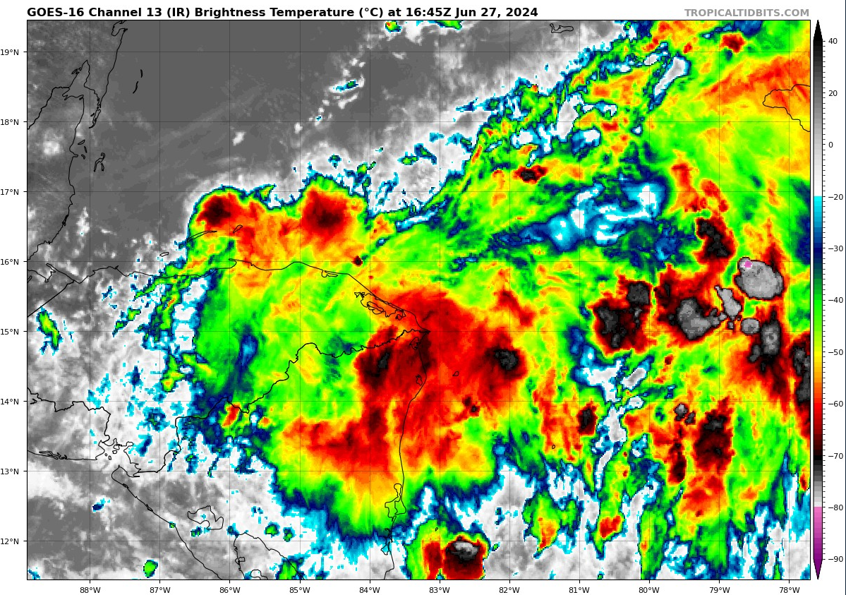
It sure looks interesting on satellite until you realize that the center is just offshore of Honduras. This should keep any development in check over the next day or two. If it can sneak into the Bay of Campeche later this weekend, it has a slight chance to do something before going ashore in Mexico. Regardless, heavy rain is likely in Central America and Mexico with flooding possible. Anywhere from 100 to 200 mm of rain (4 to 8 inches) is likely in many spots, with higher amounts (300 mm or a foot or more) possible in some spots.
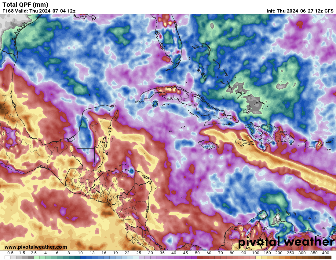
Aside from 94L, a general gyre circulation will continue to provide heavy rainfall from Panama up into Mexico as well.
What are the chances of 95L being a major hurricane?
Far too soon to speculate on the odds. Certainly a possibility, but not necessarily the most likely one.
“The tropical Atlantic thinks it’s later July or August…” This is the hype you all work so hard to dispel. Please, just the facts. Facts are what you do best. For those of us that live on the coast, we are all very well aware what is predicted for 2024. All I want are strictly facts so I can plan accordingly.
That’s not hype. Storms aren’t usually forming that far east this early in the year. In fact, “it’s fairly rare.” The whole post was about not freaking out about it and was filled with facts.
Then why add the very first part of the headline? To draw interest then dispel it. It’s a hype headline even though the content dials it back. These guys are better than this and I just hope this isn’t the start of a new era for them dipping their toes in subtle hype.
The headline is pointing out that the current activity is more typical of late July or August than June. There’s zero hype in it even if you don’t read the rest of the article.
Then go somewhere else for your weather, Olivia.
Have been following Eric since the Chron and Matt since he got to Houston.
That wasn’t hype, it was humor.
This is arguably one of, if not THE best factual, comprehensive, referenced material, hobby blog out there. (Other than SCW)
If you need 100% accuracy, my sincerest advice is to not live on the Coast
Anywhere.
You won’t have to worry about planning.
I am also willing to bet Katy won’t need to evacuate.
Hint: that’s humor, too.
Great post! Lots of good learning going on 😀
Will all the rain and winds in the bay of Campeche and southern Gulf reduce water temperatures in any meaningful way. Such that intensification may be less in the next few weeks?
Meaningfully? Probably not. Somewhat? yes. These areas are quick to recover though, even if temps drop.
Great post. All facts no hype as usual!
Is there any trend that we could see over the next two days that would be favorable to Houston? Is it better for Houston for 95L to develop very quickly, or to develop very slowly?
A very good article, no hype. Typically, June-July hurricanes tend to go south in my experience but I can see this one coming further north for the reasons you mentioned.
Headline typo.
Fixed! Thanks for this.
What about all that Sahara dust that’s heading our way? Isn’t it supposed to stop storm formation or something else is going on?
Sahara dust can’t necessarily stop storms from forming, but it can hold them back. In this case, 95L is far enough south to be away from its influence. If it tracked farther to the north, it would probably run into it and suffer.
I like the spaghetti models. It shows me just how disparate the models can be when we’re this far out. During hurricane season I come here and then go to Tropical Tidbits where I can view the models, and watch Levi’s excellent and educational videos.
Had to laugh when I looked at the GFS and the ECMWF just now. This mornings’ GFS runs had 95L going to the East Coast and the ECMWF runs going into southern Mexico. That’s quite a spread.
Wish people understood the difference between possibility and probability better.
What is likelihood that Cozumel is impacted?
It’s possible, but it’s far too soon to say in what form the system would be if it got there. Timing would be late next week though.
Worst case scenario where this becomes a named storm and heads towards the Yucatán Peninsula, ballpark idea of when it would get there?
Thursday or Friday next week maybe.