Headlines
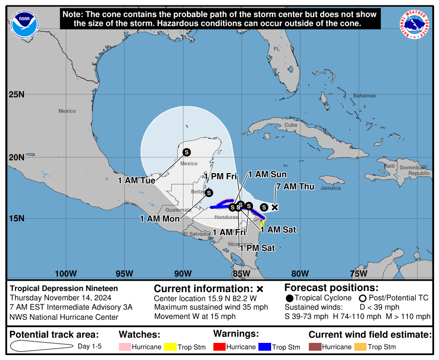
- Tropical Depression 19 should become Sara later today.
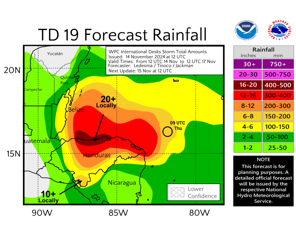
- Sara will be a deeply serious flooding threat to coastal Honduras.
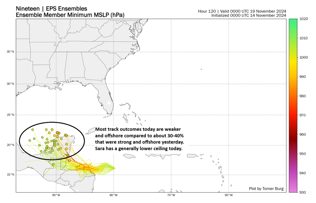
- The odds of a major hurricane, in particular a major hurricane tracking toward Florida have dropped off since yesterday.
- There is still substantial uncertainty surrounding the details of Sara’s development and peak intensity, but broadly a drift/stall near the coast of Honduras through the weekend, followed by a track toward Belize and the Yucatan and then a hook northeast toward Florida is favored.
- Also, our parent site, Space City Weather is doing our annual fundraiser if you are interested in also directly support the work of The Eyewall!
Quick sidebar: Over at our primary site for Houston, Space City Weather, we launched our annual November fundraiser yesterday. Basically, for now, it’s the one chance you have to monetarily support our work. If you don’t have extra money, please do not feel pressure to give; your using the site and spreading the word helps just as well! Ultimately, it does cost a lot to operate a website; develop, update, and support an app (something we may eventually do with The Eyewall in time); and pay for all of our other activities. So if you can help, we’d greatly appreciate it. You’re ensuring our work is freely available to all. We are grateful for any support you’re willing to provide. Thank you!
On with the show…

Tropical Depression 19: A major Honduras flood threat, less of a Florida hurricane threat
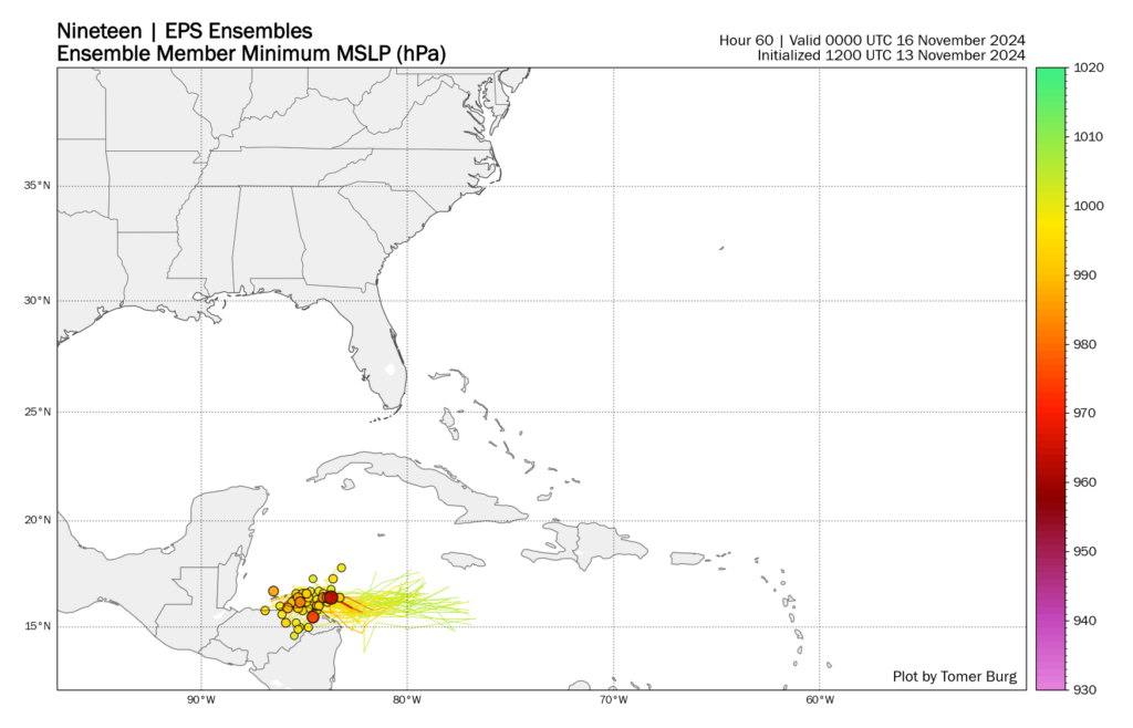
Invest 99L was given the potential tropical cyclone treatment yesterday. It’s now officially Tropical Depression 19, and it is expected to become Sara by later today. The track of 19 is pretty straightforward — but also immensely important and sensitive to exactly where it sets up. If we look at the forecast for hour 60, which is for Saturday morning, notice that the models are in pretty solid agreement. Each dot below shows where one of the 51 ensemble members is placing Sara’s center at that time.

For Honduras, unfortunately this only means the difference between a really bad situation and a really, really bad situation. Significant flash flooding and mudslides courtesy of torrential rain will be likely heading into the next several days as 19/Sara crawls along the coast of Honduras.

If the center of Sara stays offshore, it could become a hurricane, which would yield an even worse outcome. But even if that does not happen and Sara stays along the coast or just inland, the rain issues will be just as bad.
But that position of Sara over the next 3 or 4 days will have implications on what happens next for Belize, the Yucatan, and Florida. Sara should eventually get dislodged from its stall and start tracking toward Belize and the Yucatan by Monday. Obviously if it’s still over water and a hurricane, that could produce a pretty rough impact on Belize or Mexico. If it emerges from over the physical coast of Honduras, it will be less of a threat to be a hurricane.

If anything, trends since yesterday have drastically lowered the potential for a hurricane or major hurricane. There is simply too much land interaction with Honduras and the Yucatan or Belize. But there is a heaping amount of uncertainty still.
For Florida, this means that the threat of a significant hurricane on the west coast seems to have fallen off a good bit since yesterday. That’s good. I would continue to monitor this closely, but the trends have been friendly to you. There could still be some heavy rain and strong thunderstorms as a powerful cold front sweeps across the state next Wednesday. We’ll assess this in the coming days.
In the meantime, any interests in Honduras in particular, but also perhaps Belize or the Yucatan should monitor Sara closely. Even if it never becomes a hurricane, the flooding threat is dire for coastal Honduras. We’ll keep following this aspect of things.
I am currently in Belize planning to fly out Friday around 2 back to Houston. Fingers crossed that we make it out.
If you’re on Ambergris or one of the other low-lying keys, I would get to the mainland as soon as possible. If you can get an earlier return flight, I’d do that as well. In general, err on the side of caution.
Good luck! I think you might have better odds than me, I’m in Cancun and my flight back is at 8:30 Sunday morning.