Headlines
- Tropical Storm Alberto will head for a landfall in Mexico tonight, but its broad circulation is delivering rain, gusty winds, and tidal flooding impacts up and down the entire Texas coast.
- Behind Alberto, the next Gulf disturbance looks to try to track a little to the south and struggle to develop, but it may deliver a flooding risk to Mexico.
- The system nearing the Bahamas continues to look relatively unimpressive and should not have a meaningful impact on Florida at this time.
Alberto arrives
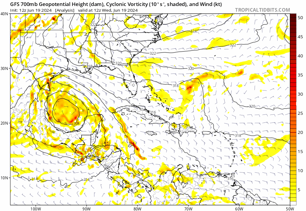
The first named storm of the 2024 Atlantic Hurricane season is officially with us now, as Tropical Storm Alberto was declared this morning. Alberto is as lopsided a storm as you’ll ever come across. Winds of tropical storm force extend out 415 miles north of the center and maybe 25 miles south.
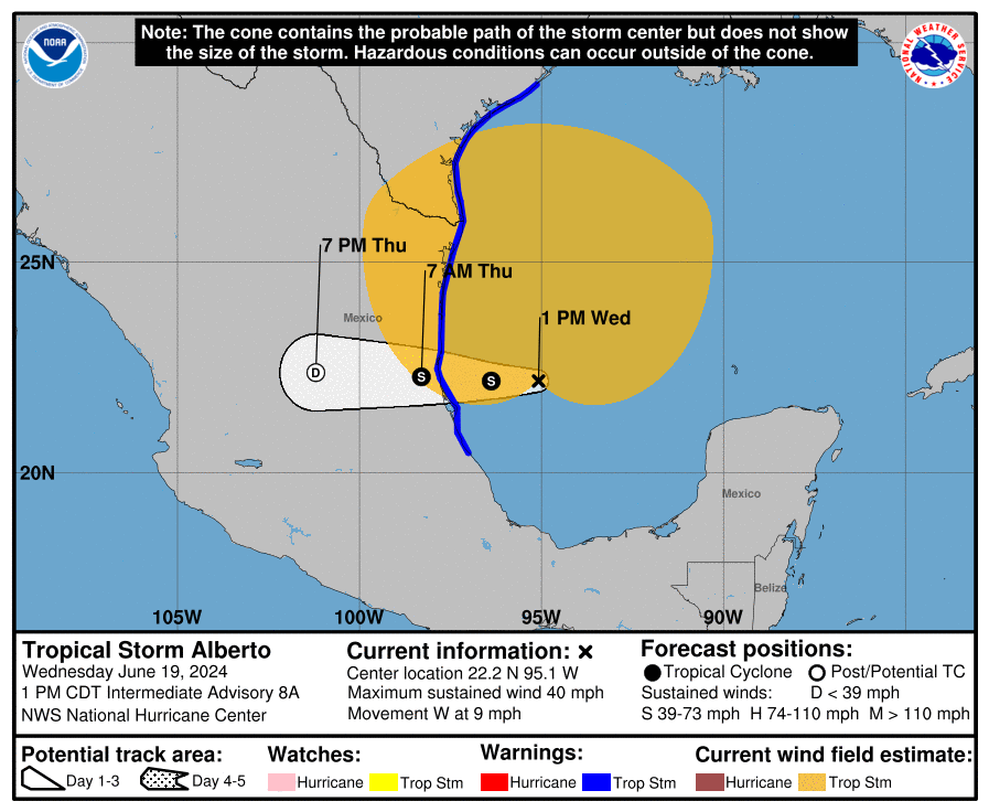
The National Hurricane Center says that Alberto has 40 mph maximum sustained winds. We’ve seen frequent gusts all the way up into the Galveston area of 40 to 45 mph or even a bit stronger at times, which is about on brand for a storm of this nature. Persistent easterly flow across the Gulf and the large swath of wind accompanying Alberto has made its storm surge perform in an outsized manner for a typical low-end tropical storm. For instance, San Luis Pass, just southwest of Galveston is experiencing a surge level around 4 feet at the moment.
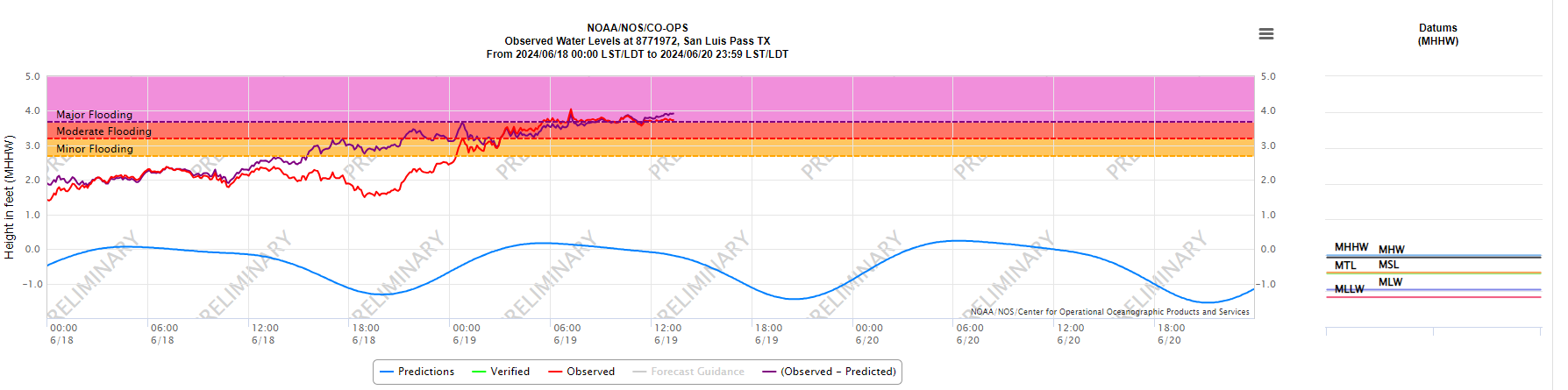
For some places, the tide levels will meet or even come close to exceed the levels met during Hurricane Nicholas in 2021. Either way, this is the highest water in a few years on the Upper Texas Coast. You can view a wide range of tide gauges on this special NOAA site for Tropical Storm Alberto.
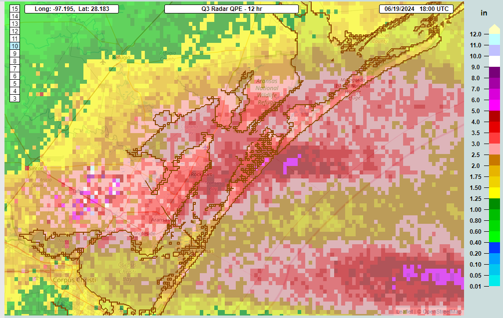
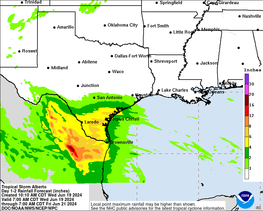
Meanwhile, rainfall continues to add up. It was slow to start last night and this morning, but it has kicked into gear today. We’ve seen squalls with strong winds, possible tornadoes, and rain rates currently approaching 2 inches in an hour with storms passing through Rockport, Fulton, and Sinton north of Corpus Christi. Storm totals so far are as high as nearly 5 inches just east of Rockport.
Rain, squalls, and thunderstorms will continue to push ashore this afternoon and evening along the Texas coast, with a few spots seeing several more inches of rain perhaps, especially from near Surfside Beach southwest of Galveston into South Texas.
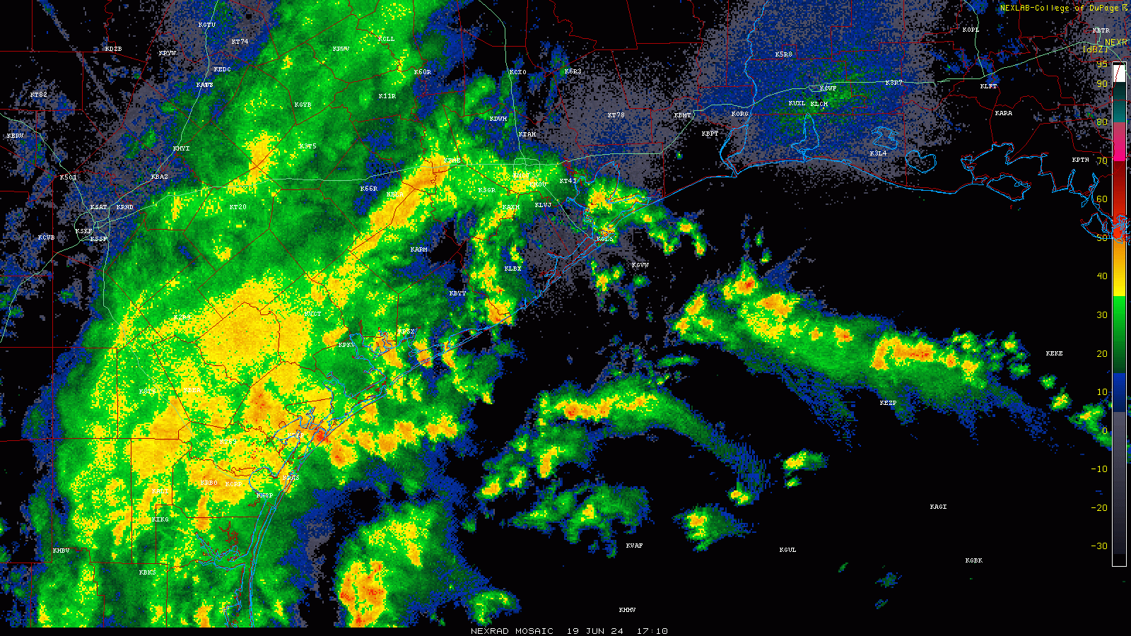
This rain is deceptively heavy, as evidenced by some torrential downpours in Houston this afternoon leading to localized street flooding. And combined with high tides, watch for flooding along the bays of Texas, as well as the Gulf waterfront. Even parts of southwest Louisiana, as expected, are dealing with tidal flooding. The worst of tidal flooding should be occurring now, or shortly, with a gradual decline in tides tonight and tomorrow as the winds slowly ease up.
Again, also be mindful of waterspouts or quick tornadoes along the coast, particularly from Matagorda Bay into far south Texas.
Total additional rainfall will be on the order of 4 to 8 inches in South Texas, including the metros in the Valley between Laredo and Brownsville. Flash flooding remains possible there. Higher amounts will likely occur in northern Mexico, with upward of 16 inches of rain in the mountains and a risk for mudslides and flooding.
Alberto should release its grip on Texas and Mexico weather after tomorrow.
What’s next for the western Gulf?
Once Alberto gets out of the way, these areas will get about 2 days of quiet weather before the next iteration of the Central American Gyre kicks into gear.
The good news is that the National Hurricane Center is maintaining low odds of development with this next system. The other good news is that modeling is tracking this thing farther south than Alberto, so hopefully it avoids repeating the exact same outcome over South Texas and northern Mexico that would lead to a higher likelihood of flooding the second time around. It also looks less impressive than Alberto did on model guidance to this point, so I think we’re setting up for a lower-end system, maybe a depression moving into central Mexico on Sunday or Monday.
For now, look for something like 1 to 3 inches on average south of Corpus Christi into Mexico. Models indicate that especially in the Sierra Madre Oriental just inland from the coast of Mexico could see upwards of 5 to 12 inches (125 to 300 mm) of rainfall. So flooding will be something to watch in Mexico, with or without a defined tropical system.
Off the Atlantic coast
The NHC continues to advertise about a 20 percent possibility of development from the disturbance in the Atlantic Ocean that will work toward Florida in the coming days.
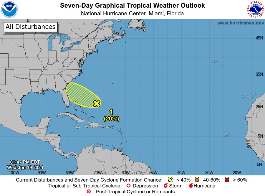
This does not seem likely to develop, and even if it does, it will be doing so in an environment that’s less than ideal for strengthening. So there should be a pretty firm cap on how strong this can get. Either way, rain chances may pick up a little in Florida or the Southeast next week, but that should be about all.
Elsewhere, things look quiet for now. There were some operational model hints that perhaps this Atlantic system could get pulled into the Gulf and try to slowly organize, but those are low impact, outlier scenarios right now and we won’t be taking them seriously at this point.
Isn’t this area in Mexico suffering from a drought? These rains will be beneficial?
Mostly. But anytime you get that much rain in the mountains it can cause problems.
Have you considered hosting the Eyewall posts on the Space City Weather app? It would be nice to get phone notifications for both sets of posts. I imagine it wouldn’t be much more work to just push the articles (unless you wanted to add a button to toggle on/off notifications from the SCW and Eyewall posts separately, so non-Houstonians can use it).
We have not, but I imagine it’s something we’ll consider at some time, pending our growth here!
At 4:37 pm, here in Sienna Steep Bank East, it is raining hard, at a peak rate of 2″ per hour and 1.77″ has fallen since Midnight, with most of it in the past 2 hours. I hope the end of the rain band is in sight, and will move past us soon.
Flying back to Bush Airport today from CA on a nonstop. Airport was severely impacted by weather. Many planes in holding awaiting landing in Houston. Our flight diverted to Dallas to refuel.
That’s one reason we don’t really predict air travel for people who always ask. There’s almost always a chance for a delay when something like this happens.