Headlines
- Model support for tropical development in the Caribbean has fallen off a bit since yesterday, but the wave that moves through there next week does still bear watching.
- Low pressure in the Gulf of Mexico continues to serve up locally heavy rain on the Texas coast, where totals are approaching 10 inches or more.
- Additional rain or localized flooding is likely through the week, shifting south a bit toward Corpus Christi as the week progresses. Tropical development, if any, would be slow and still on the lower end of intensity.
The little Caribbean wave that may or may not
Something funny has happened with hurricane season this year. Storms early on tended to outperform model expectations. Systems since mid-August that have shown in modeling are tending to look more lackluster longer. And indeed, the tropical wave we’ve been discussing that will pass through the Caribbean this week is following that pattern. Yesterday, the National Hurricane Center boosted development odds to 50 percent, only to back it down later to 40 percent. We’re still there today, but model trends in the last 24 hours have pulled back even more.
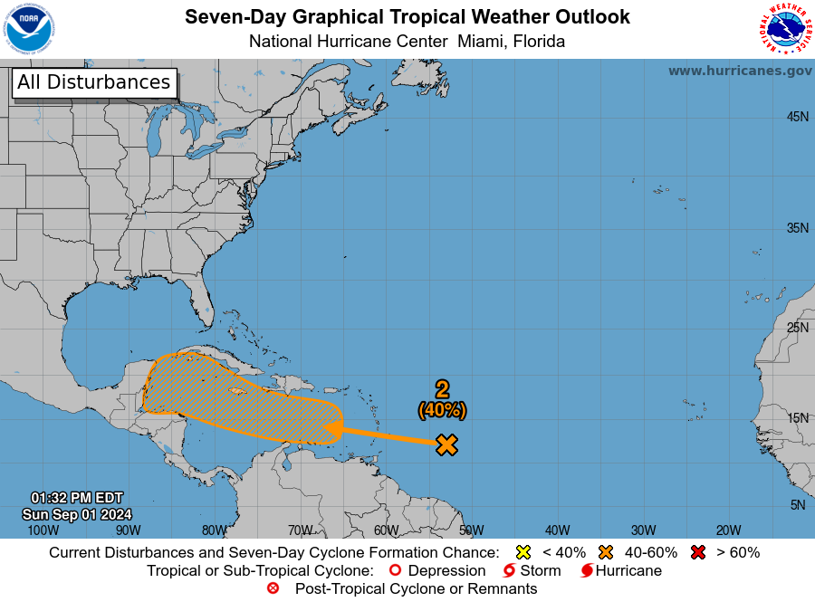
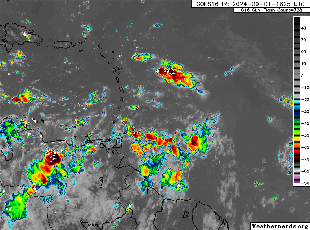
On satellite, this tropical wave remains nothing impressive. Yes, it has thunderstorms with it, and there will definitely be some heavy rain moving into the Lesser Antilles early this week, but any development is non-existent at this point.
And, look, that’s what we expected. We’ve been saying most of the last week that this was not going to be quick to develop, and so far that seems to be playing out. Yesterday we noted the inflection point that this system would hit in the western Caribbean when the atmosphere got a little less hostile to tropical development. We also noted that there was a distinct split in the European model ensembles with a bunch staying weak and going west toward Mexico or Central America and some that strengthened and turned northward. Indeed that continues today, but if the split was 60/40 yesterday, it’s 80/20 or even 90/10 today!
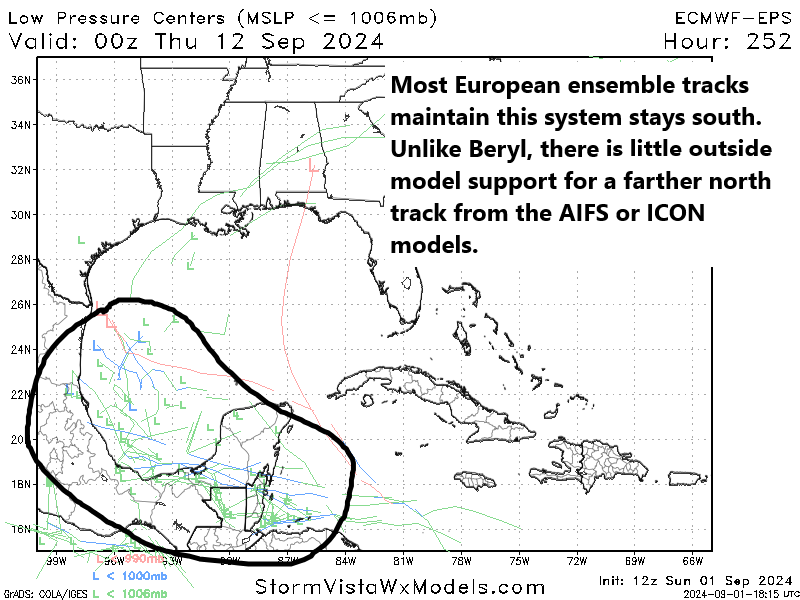
The first thing many of you will say is “Oh, you said Beryl was supposed to do that too and look what happened!” That’s an understandable reaction. The difference this time around is 1.) this system is in no hurry to develop whereas Beryl was a Category 5 hurricane in the Caribbean, 2.) there is no real model support from models like the ICON or AIFS (AI version of the Euro) or even the GFS, and 3.) We have a cold front sitting off the Gulf Coast as this one approaches the western Caribbean. So this is a fundamentally different setup than in Beryl. We are going to continue to keep tabs on this obviously, but the message since yesterday has been to back down somewhat on development odds. There’s just something hindering development in the Atlantic basin right now. I think we continue to see generally sinking air in the western Atlantic in the background and overall more stability in the atmosphere than had been expected this season. This may now continue into mid-September.
Texas coast tallying nearly double digit rains
We’ve seen an additional 3 to 5 inches of rain since yesterday between Baytown, just east of Houston down to the Bolivar Peninsula and out to about High Island, bringing totals since Thursday up to about 6 to 12 inches of rain along the coast and just inland for portions of Texas. The highest officially measured total I’ve seen is 9.17″ at JB’s Seafood in Crystal Beach, where I believe Jefferson County has a gauge.
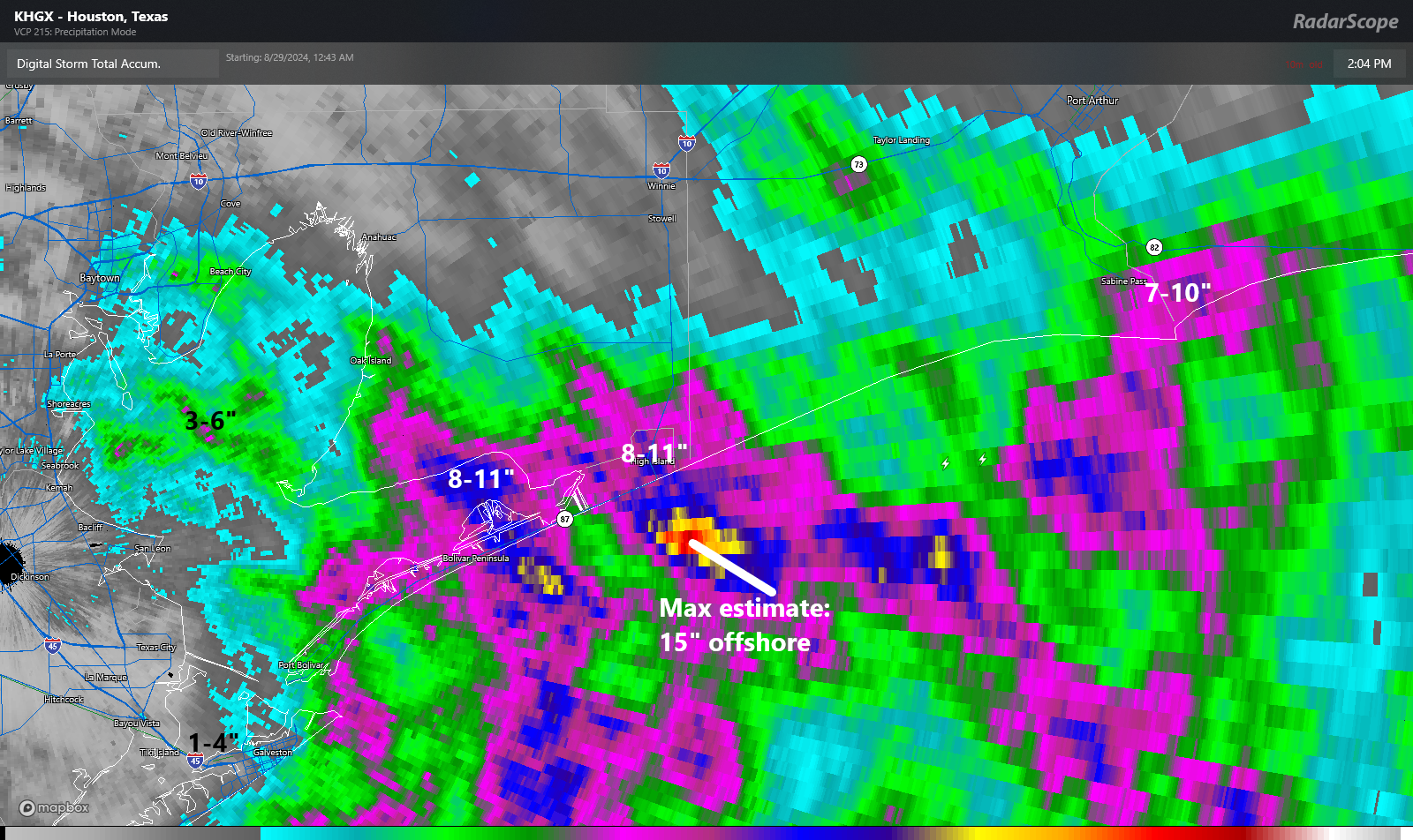
Overall, models snuffed this one out well, though they were a bit overzealous inland. In the meantime, surface low pressure continues swirling today about 50 to 75 miles southeast of Galveston. It remains very disorganized.
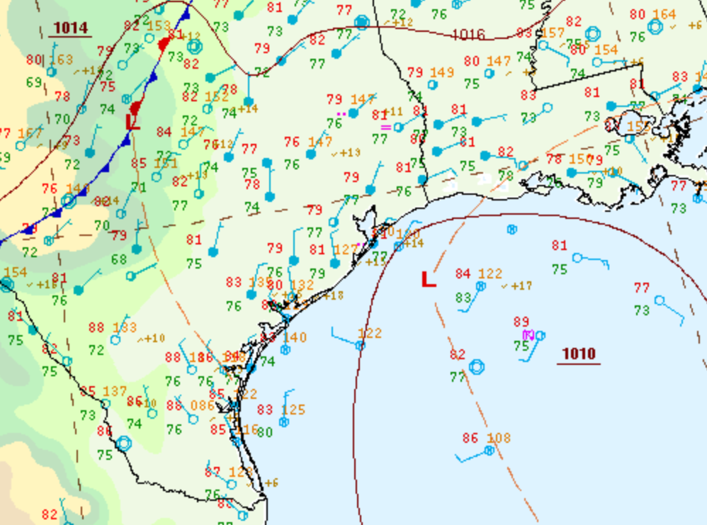
The low is expected to continue drifting offshore of Galveston for a few more days. It may eventually trend southward with time, closer to Corpus Christi. All the while there will remain a low chance it develops a little. But rapid intensification or strong organization is not expected with this system. Rainfall over the next 5 days looks to be on the order of 3 to 6 inches between Corpus Christi and Sabine Pass, with locally higher and lower amounts. A localized flash flooding risk remains very much in play for these areas.
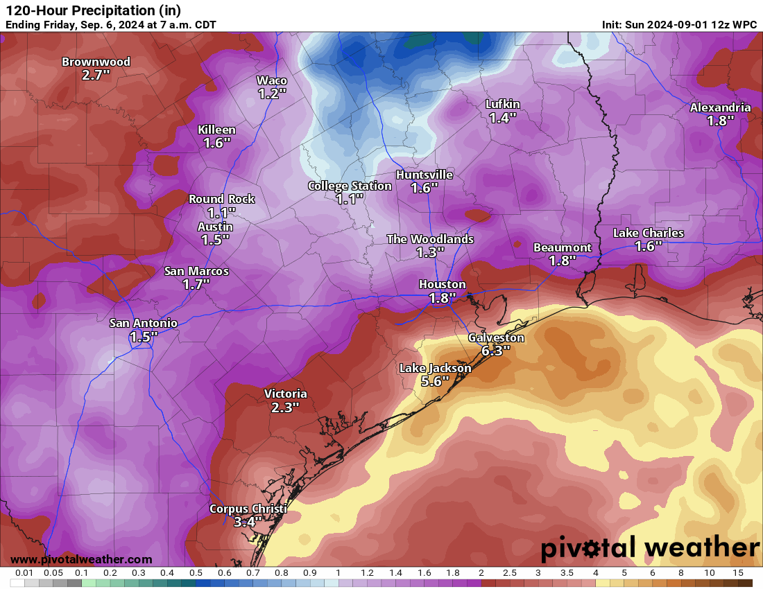
Thankfully, the rain has mostly been coming at a pace that is manageable. It’s just adding up in these locations over time. And that can lead to localized flooding eventually. For Houston, Beaumont, and Lake Charles, this is mostly a non-event with just passing showers or storms in the cards over the next several days. The stalled front in interior Texas may focus rainfall through the week in drier parts of the state.
Elsewhere, no tropical development of note is expected, and certainly no land impacts are expected over the next week.
The National Hurricane Center is forecasting the low near Galveston to move inland on or about Tuesday and no further development would be expected after that.
Do you still see a decent chance of a tropical storm or hurricane later in September or beyond? I have been out of town and do not want to return until the “coast looks clear.”
September is known the be the most active month in the season. Good chance storms will develop, best to keep up to date with weather reports while out of town
The 12z ECENS seems to decrease support for it even further.
My concern is the 12z GFS scenario where the back of the front pulls whatever storm this is north out of the BoC, or that the BoC becomes an area of tropical development.
“Low pressure in the Gulf of Mexico continues to serve up locally heavy rain on the Texas coast, where totals are approaching 10 inches or more. ”
Not a drop yet. Someone must be getting wet, but not us.
Southwest edge of Midtown, only about an inch here since the heat departed.
What happened to the MJO that was supposed to increase rising air over the western atlantic in the beginning of September?
Is this low pressure system that has been hovering along the coast taking away warm water energy that might be fuel for a potential near future more intense storm