Headlines
- Slow development of the Atlantic tropical wave is likely this weekend near the Bahamas.
- The track of the system is highly uncertain with some plausible outcomes ranging between the eastern Gulf and offshore of the East Coast.
- Interests from Louisiana to Florida to the Carolinas should continue to monitor the progress of this system, even though current expectations are not for a major storm.
It’s a slow go from the Atlantic wave
We continue to track a tropical wave in the open Atlantic this afternoon that the National Hurricane Center continues to gradually beef up development odds on. This afternoon they stand at 60 percent over the next 7 days (near zero the next 2 days).
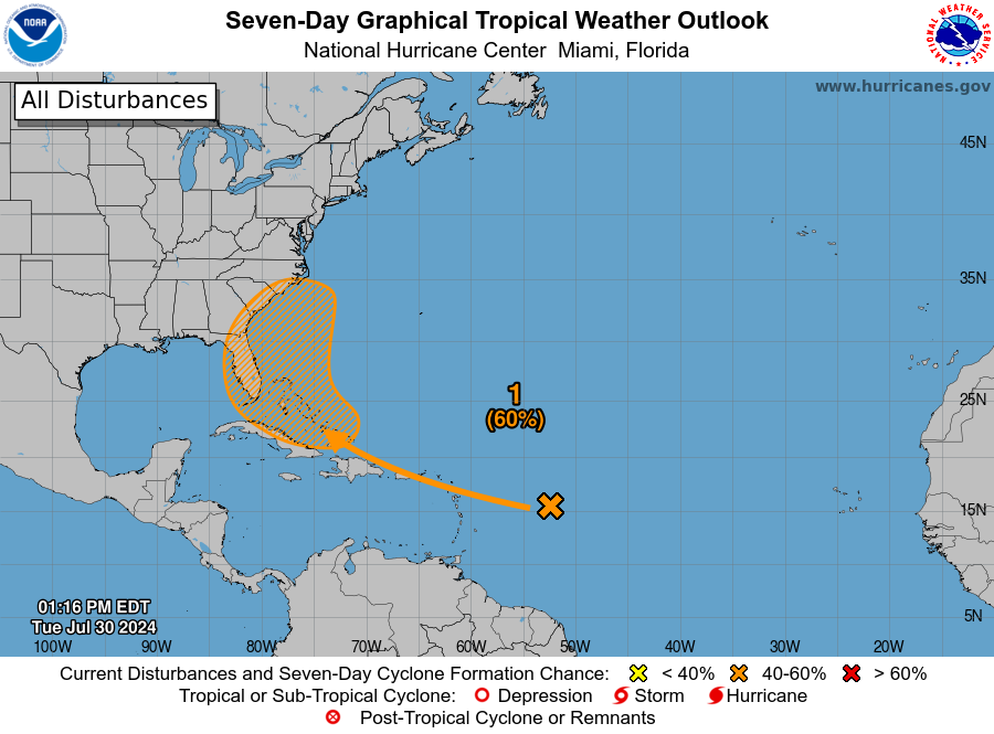
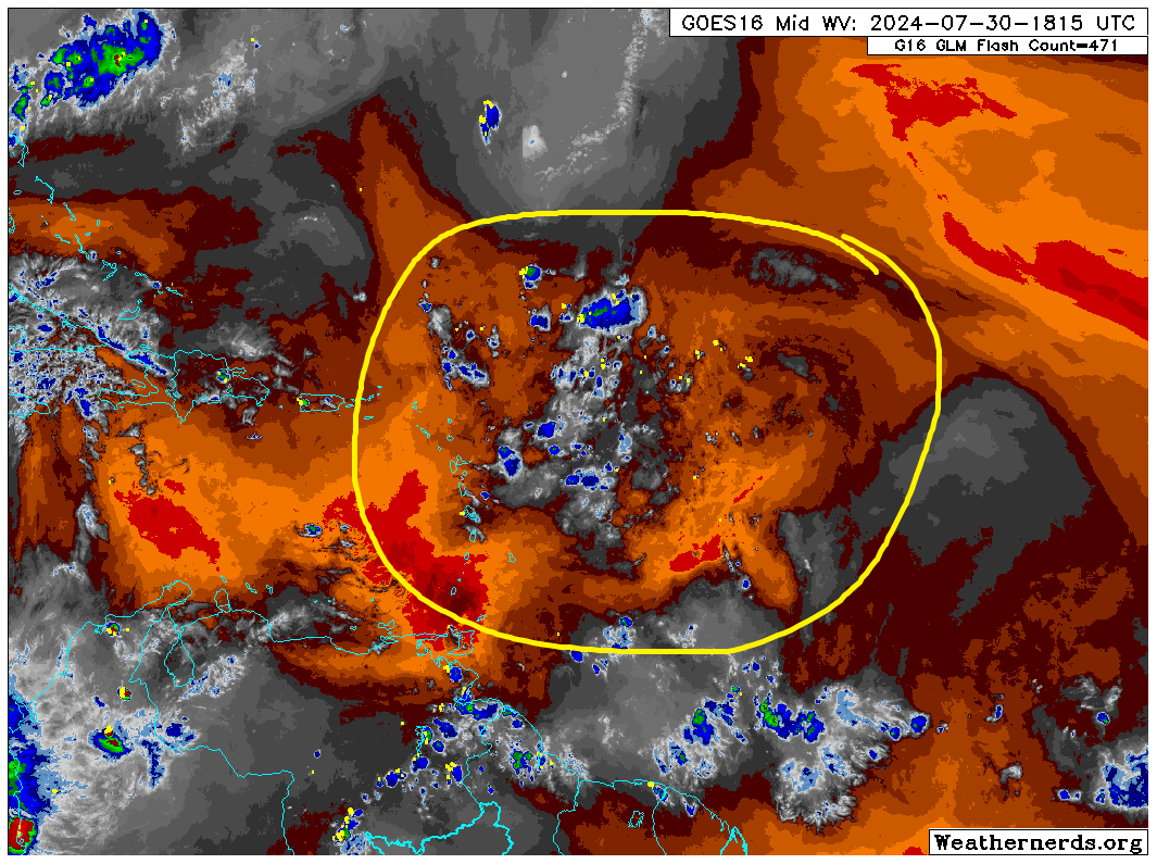
This is a larger, lumbering wave with slowly increasing thunderstorm activity. Larger waves are generally slower to develop, and given how much dry air this thing still has to shed, we likely won’t see any real movement toward organization until this weekend. But compared to Monday it certainly looks better I guess.
We should see a touch more in the way of storminess around this wave tomorrow and again on Thursday. Once we get to Friday or Saturday and this approaches the Bahamas, that’s when we could finally begin to see organization.
From that point, this wave’s future is cloudy. If you dig into the European ensemble’s 51 members, you can actually get a good picture of the possible outcomes. No ensemble spread is perfect, but this gives you a very high level understanding of the generic possibilities that exist with this wave. I’ve broken them into 3 camps below.
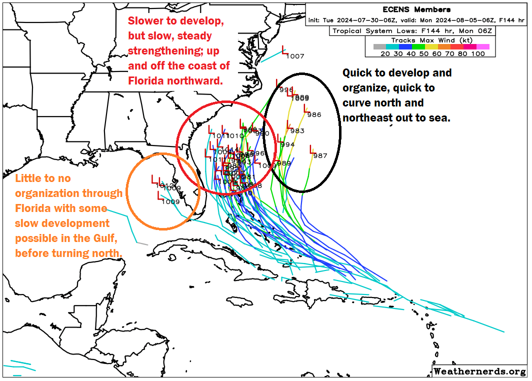
On the right, we have the more aggressive solutions, which include the Euro operational and ICON models at present. These quickly strengthen the wave in the Bahamas such that it gets pulled north by a trough, generally remaining offshore, away from land and probably not a huge deal for anyone. This solution seems a bit overaggressive to me, so I’d say odds of this are relatively low. But it’s a possibility.
In the middle, you get the general consensus view of the Euro ensemble which is a storm that only slowly strengthens and organizes, still enough to turn it north, but not before it gets closer to Florida and the Bahamas and potentially close enough to eventually threaten the Carolinas. In this case, you still probably wouldn’t have a particularly strong storm, but you’d have something a little better organized than just a wave or depression. European A.I. modeling also supports a hybrid of this outcome and the previous one, closer to the coast but still offshore.
Then, on the left, you have a small cluster of a couple ensemble members that do not develop the wave at all and allow it to continue west or west-northwest into the eastern Gulf of Mexico. Eventually it would probably still turn north, but because the upper air pattern steering this thing would be fairly convoluted next week, any confidence in where that happens would be quite low. Still, this would likely only gradually organize in this scenario. The GFS operational model supports this outcome at present. Notably, that model also places a little mid-level system ahead of the tropical wave which would probably boost wind shear a bit and could help direct it north a little faster. Maybe. It’s complicated.
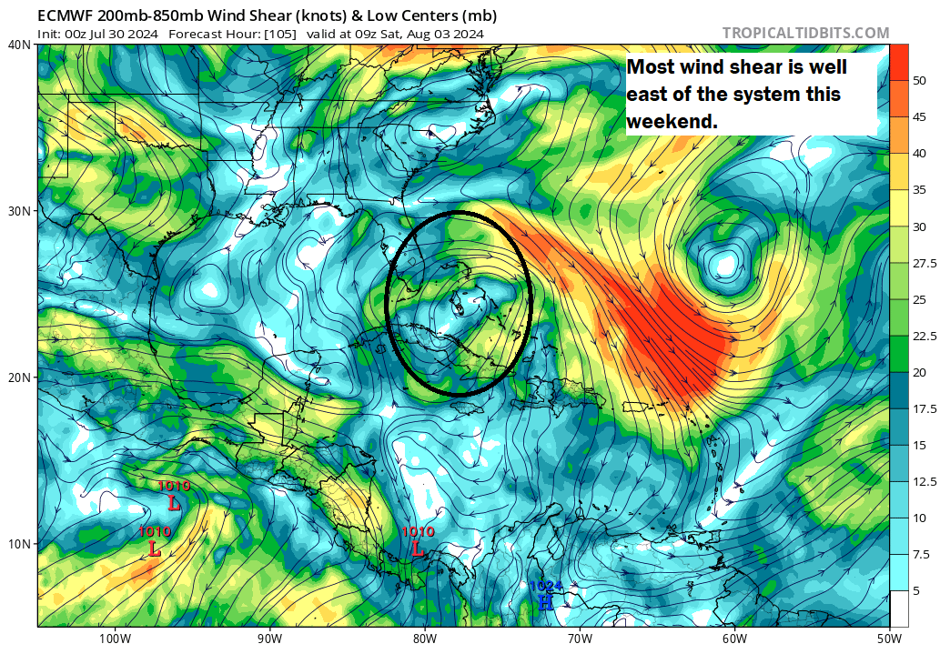
What does it all mean? They’re scenarios for a reason. Is one more likely than the other? Well, the middle one seems to have more support among modeling. The GFS is sometimes a bit wonky with these things, so I’m not sure I entirely buy the Gulf scenario. And it’s noteworthy that despite the expected slow organization of this system, between warm water and extremely low wind shear, conditions look pretty good for some strengthening near the Bahamas this weekend.
The meteorologist in me favors some combination of the Euro op’s quicker strengthening and the middle majority cluster right now. This would yield minimal direct impacts. But the public communicator in me must tell you that interests from Louisiana through the Carolinas should continue to monitor the progress of this tropical wave. Even if it’s not currently expected to be a significant storm, it will have a few things going for it as it organizes.
In summary:
- Slow organization is expected this weekend near the Bahamas.
- The track is uncertain, with some modeling quickly strengthening the wave and turning it out to sea, while other modeling brings it closer to Florida or the Carolinas and even a few not forming it at all, bringing it into the Gulf.
- At the least, a tropical system should form, but where and when exactly remains to be seen.
- Interests from Louisiana and the Carolinas should continue monitoring the progress of the wave in the coming days.
I will be out of pocket the next few days for some medical stuff, but Eric has you covered going into the weekend!
Good luck with the medical stuff! Hurricane season will just have to wait until you return!