In brief: Barry has dissipated. Next, we’ll watch the northeast Gulf or southwest Atlantic for development by this weekend, though there’s only modest support for something formal at this time. Elsewhere, Tropical Storm Flossie is likely to become another Pacific hurricane tonight, with heavy rain and tropical storm conditions for parts of the Mexico coast.
Like Tropical Storm Andrea earlier in the month, Tropical Storm Barry held that title for a full 12 hours yesterday. Two names down covering 24 total hours? We could get used to this. Anyway, now we move onto the next development chance.
Gulf or Atlantic? Who’s next?
Over the next several days, we’re going to see repeated rounds of thunderstorms near the Florida Panhandle or just off the First Coast in northeast Florida. By the time we get to Thursday or Friday, a cool front is going to drop into the area and basically stall out, or “wash” out nearby, a typical feature a couple times per summer.
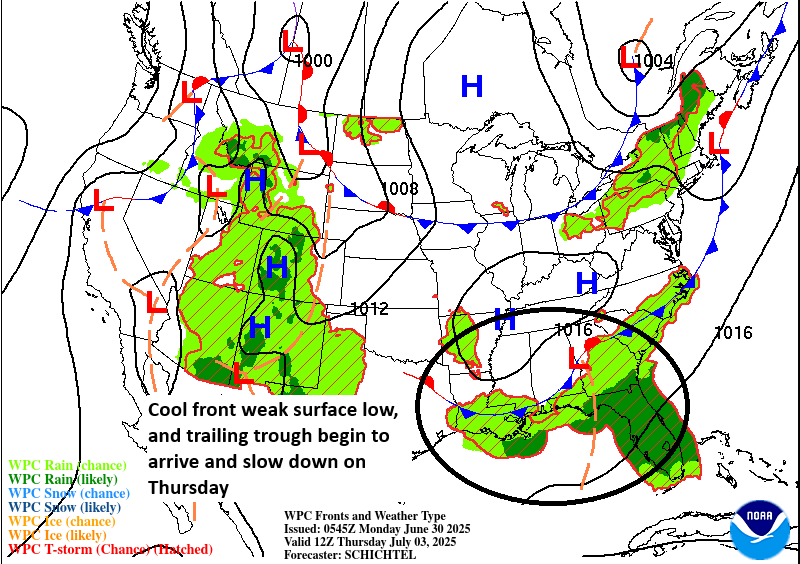
With these festering thunderstorms and an approaching front, it may be just the shot in the arm this area needs to begin to try to organize. The biggest questions right now revolve around where exactly this happens and what sort of environment it will have to organize in. We know that there will probably be some sort of disturbance that consolidates between the northeast Gulf or southwest Atlantic this weekend.

Steering currents this weekend and early next week look fairly weak, so whatever does form could scoot out into the Atlantic slowly, or drift west southwest through the Gulf. Before anyone panics over this, I think there are a couple things we can say. Systems trying to develop this close to land tend to struggle. Also, there will be a fair bit of dry air around the Gulf Coast early next week that should cause this to struggle a bit as well. Another occasional outcome is that sometimes these disturbances split up some instead of consolidating, and a piece of it would go west and another east.
In terms of model support, reliable modeling tends to be subdued in terms of how this develops, with one or two stronger outliers out of 100 or so ensemble members.
So sitting here on Monday, all we can really do is just watch the evolution of this on modeling. A couple things can be said. There should be a disturbance. There’s not much support for significant development, and there is modest support for sloppy development. One thing there is high confidence in is that the Gulf Coast of Florida is going to get whacked by heavy rainfall.
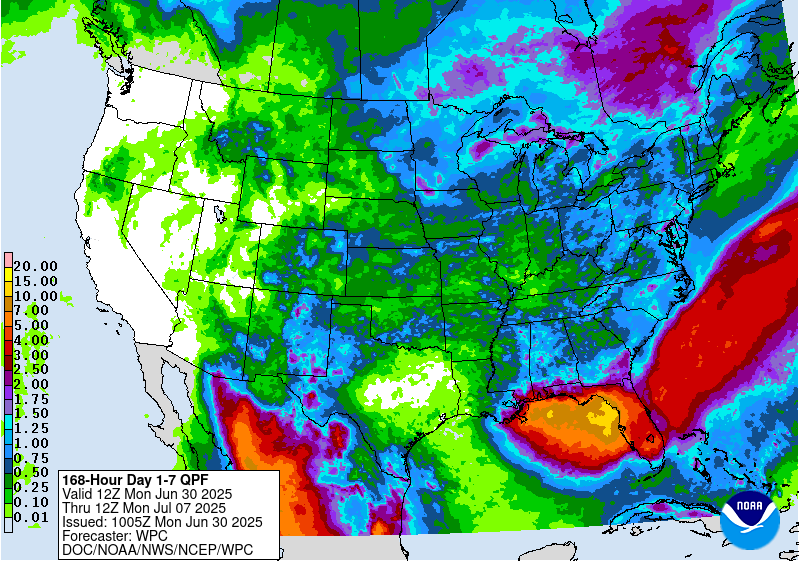
The current NWS forecast shows upwards of 10 to 15 inches of rain or more possible just along the coast of the Big Bend and in the open Gulf. There will likely be some street flooding issues at times along the west coast and Panhandle coast of Florida. Heavy rain may also extend back west to Mobile and coastal Mississippi. This will be the biggest impact concern through early next week. More to come.
Elsewhere
Tropical Storm Flossie in the Pacific is going to become a hurricane by tonight in all likelihood. It will pass along and off the coast of Mexico, bringing heavy rain to the coast. Tropical Storm Watches and Warnings are posted there.
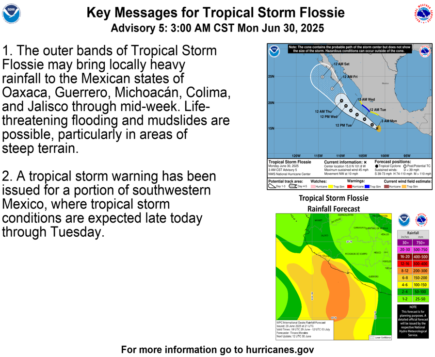
Flossie will significantly weaken as it approaches Baja and enters much colder water. Minimal impacts are expected there, and Flossie’s remnants may get directed out into the open Pacific next week.
Additional development is possible in the Eastern Pacific behind Flossie.
Euro models have a chance of this Florida development swinging back to Texas next week to hit near Houston. Do you put any credence in those models?
If it does do that (it’s possible) it would probably track west or WSW across the Gulf and may end up in Mexico truthfully. Even in that scenario, you’d still probably see the system struggle a good bit due to dry air from the continent. So I’d say, yes it’s possible, but not as a strong storm.