Headlines
- Today’s post shows how modeling is struggling to handle what may or may not happen in the Caribbean next week.
- At this point, we expect tropical development, but where that goes, at what intensity, and at what speed are all open questions we cannot currently answer.
Caribbean confidence levels low
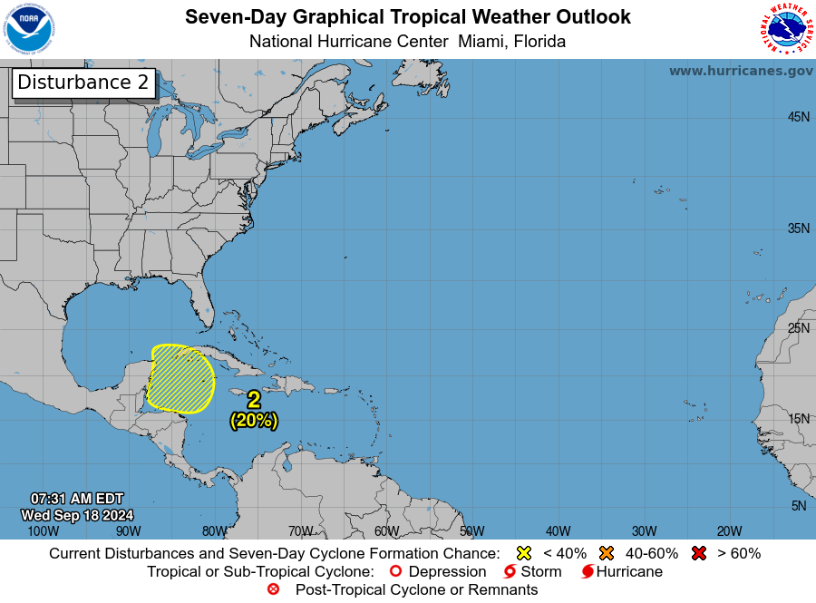
Rather than go into a post where I go back and forth on hypotheticals regarding potential Caribbean development next week, I want to go into how we should be thinking about this, sitting here on Wednesday, September 18th. First, the easy part: The National Hurricane Center has given the northwest Caribbean about a 20 percent chance of tropical development over the next week.
You may be asking why this seems so low. The NHC operates fairly conservatively, so expect these odds to probably increase as we get closer. After all, it’s not a given that we’re going to see tropical development in the northwest Caribbean. It’s a possibility.
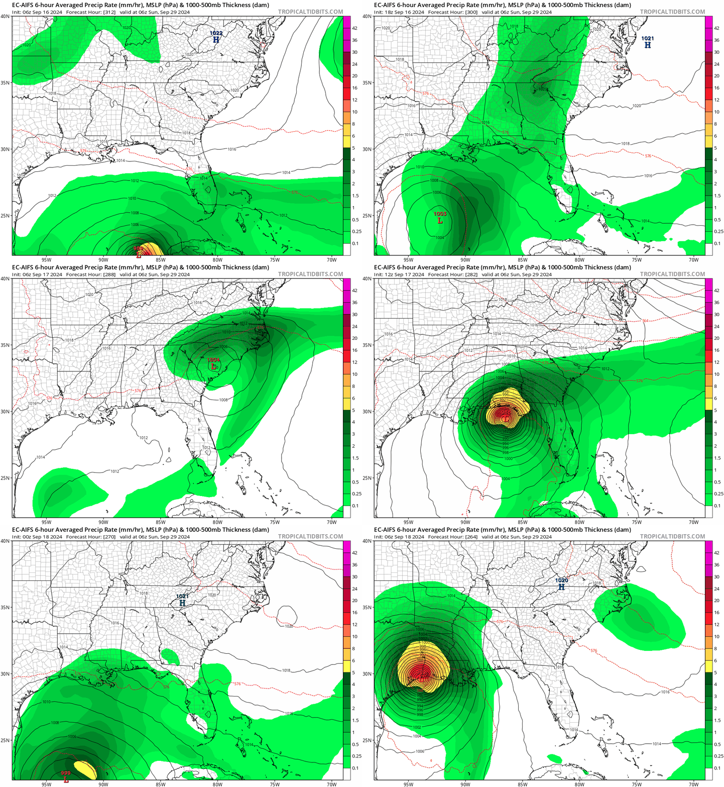
During Hurricane Beryl and again during Francine, we noted how good the European AI model and ICON model handled the storms. They were consistent on track and fairly consistent on the idea of intensity, particularly in the 5 days ahead of landfall, while other models were still generally bouncing around. So why can’t we just use those models and get a good idea of what may occur here? Well, here are the last 8 runs of the European AIFS model valid for next Sunday morning.

If you look at the GFS or ICON or whoever else you want, you would see a similar outcome. None of the operational modeling has any consistency or clue with respect to this system, short of “something might happen somewhere.” So when we tell you to ignore and disregard people posting single run deterministic models on social media saying “not a forecast, but check this out!” this is what we mean.
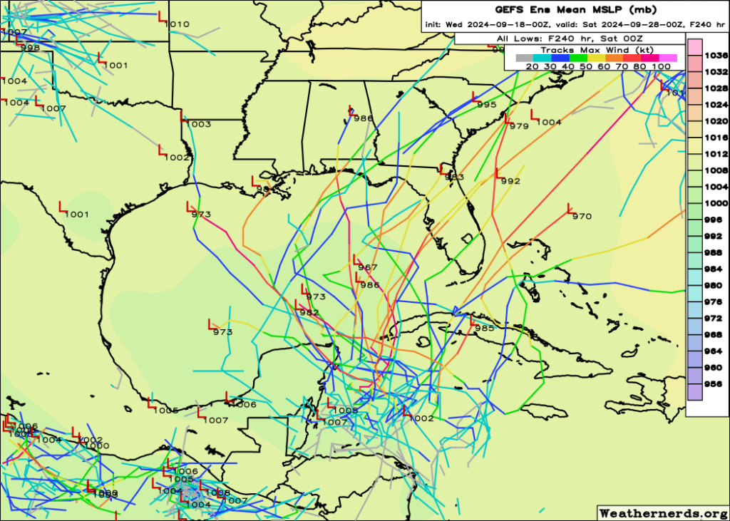
So the next thing you may ask is, “Matt, you’re a meteorologist. Isn’t it your job to cut through this and tell me what might happen?” And the answer is yes. However, I know my limits. When I look at GFS and European ensemble guidance, the traditional physics-based ensembles I see similar type outcomes with a wide berth of possibilities. Some go northwest, some go northeast, some don’t even develop it at all.

Finding signal in the noise is my job, and right now the only signal I maybe see is a propensity for the majority of model guidance to go north or northeast with this. And even that is sketchy at best. But it tells me Florida absolutely needs to watch this closely. And since we’re more than a week out from any impacts, that’s probably good enough.
The goal of a meteorologist this far in advance is not to get the call spot on. Anyone can try to do that, and periodically they’ll nail it while also likely delivering 65 other false alarms in the process. The goal of the meteorologist is to tell the audience what we know. We could dive deeper into the upper air pattern or things like that, but I feel we’re still a couple days away from getting too fancy with explaining how that impacts this outcome. But I’m not cherry picking model runs or data. I’m showing you examples of erratic deterministic output, which is all we have right now, and I’m showing you examples of slightly more stable though no less uncertain ensemble data. It’s a lot of noise, so don’t be panicked by individual cherry picked runs.
The bottom line right now? We have no idea what will form, exactly where it will form, and where it will go. But we are fairly confident that something is going to develop in the northwest Caribbean next week.
We’ll keep it simple today and leave it there.

We are SW of Lake Okeechobee and saturated from regular afternoon heavy thunderstorms. A wind event will bring down trees and the last thing we need is more water. Hoping the steering currents can minimize anything we see. Thanks for the warning guys.
There’s a Yeti in that spaghetti…somewhere.
Joking aside, this is a solid post on all the background noise the pros distill into bite sized pieces for the masses to easily consume.
It’s always neat to get a look under the hood at why “something might happen somewhere” is the best offering at the moment.
Today’s SCW said “along the upper Texas coast this is probably not something to be too concerned about”
I think this meant “at this early time, every point from the tip of Florida to the central Mexican coast has the same chance of getting a tropical storm from this”
Is this what it meant?
Essentially, yes, but in reality, we probably do favor a risk in the eastern half of the Gulf than our half, primarily because we have a shot at cool fronts next week that would keep this there. But I don’t want to oversell the risk being too low.
Yes, today I saw the Euro models, including the AI, having a tropical something head straight for or close to Houston…So I’m keeping my fingers crossed that we are spared..
Hi guys my late Daddy would also use the line I think we will leave that right there where it’s at.
Thanks for all y’all do to help keep us informed and safe.
Ken
Until something forms it is very difficult. Also the upper air pattern differs from model to model. That is always the case this far out. One is faster one is slower etc. You are right Matt we just know that something will probably form and past history shows something that forms there and when fronts are involved usually northeast gulf but who knows, i have seen crazier
This year everything we’ve seen to hit the gulf has been very slow to form..So while we feel like we’re forever watching these disturbances , it’s frustrating, because we don’t have a narrow range of possibilities on where a hurricane is going to hit until said hurricane is 1 or 2 days from somebody’s doorstep..
Well played, Matt. In this case I think “we don’t know what will develop or when” is preferable to hazarding a guess.
It doesn’t make sense, right? I’m not here to feed someone a solution that has a 2% chance to verify…people can get that anywhere. I’m here to tell you what we know in as coherent, honest, and real a manner as is possible. One of the lessons of Beryl for me is both to not downplay a possibility overaggressively. But also I will maintain that there was also a lot of cat 5 garbage spewed about US threats from Beryl that never materialized. So I’m not going to swing back the other way either.
Hypothetical wild crazy guess:
Tue the circular possibility creeps above Mérida, on Wed it’s in west-central Gulf, Thur it’s heading to northwest FL coast.
But no doubt, nothing’ll happen 🙂
Correction on the wild guess – it’ll linger in the Gulf a couple more days and arrive along coastline below Lafayette on Sat, 28
But it’s doubtful
Seems like the current models are having trouble coping with the changing intensities of the storm physics.
All that signaling Matt is looking for must be getting hard to find in the soupiness. Needle in the increasingly murky haystack.
So GLAD Matt & Eric are here using their meteorological superpowers to help us understand what we’re dealing with. They need capes with big Ms on them 🦸♂️
🛡⚡👍🏻
This is what I do not get. The conservative Hurricane Center gives a 30% chance of development in 7 days. That is considered “likely”? Wouldn’t likely be north of 50%?
I guess it is a greater than 50% percent chance after 7 days?
To further confuse things for me, Gordon is at 50% of reforming.
I have my hurricane plan, so I should not really be concerned about anything until it is at least 50%, right?
This system is so messed up. You got the CSU guys rooting for bad weather so their precious forecast won’t go down in flames. Then there are the thousands of click bait sites forecasting doom.
That said, I appreciate your site and enkiops.org giving a more honest view of things.
Thanks
At 48 hours so halfway to Yucatan from landfall the experts mostly have pinned down the path. I estimate. Then at 48 rush into action, hit the road before they fill w cars.. . Or if staying at 48 buy huge lithium power bank, 12v fan, and fill fridges with ice – for week without power maybe … At 48 I may move my boat into safer marina, if experts say it’s gonna hit Houston metro.
I love you guys. No nonsense and great explanations.
It seems as season goes past late Sept, Texas doesn’t get more than Cat 2. It seems a hurricane forming off Cozumel in the 1000 miles to Houston also rarely has time to develop past Cat 2, but I could be wrong. Are we likely late Sept to see Cat 3 or more in Texas… .. As guess Id say Houston metro whole year has 20% chance of Cat 1 (so every 5 years), and bigger storms 10% (so every 10 years). Using math, we are half done, and into later half (smaller half), so maybe 10% chance of anything hitting Houston metro rest of year. Yes I’m guessing, but it feels reassuring to know ok a destructive storm is not a high risk right now ..