Headlines
- Significant increase in rain chances for Florida this week will likely begin to lead to some flooding concerns, mainly for the Peninsula.
- A firehose of moisture should begin to extend north and west from the FL Peninsula next week.
- Portions of Florida will likely see 10 to 15 inches of rain or more through next week with chances of double digit rainfall totals expanding to the west in time.
Gulf moisture surge ahead
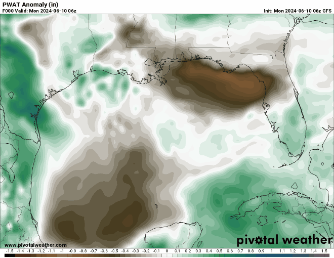
Put simply: The next 10 to 14 or so days in the Gulf of Mexico will feature a firehose of moisture that is likely to have wide ranging impacts from Florida to perhaps Texas. Ultimately this may serve as a reminder that a system does not need to be a hurricane or even have a name to cause widespread impacts.
What’s the meteorology behind this?
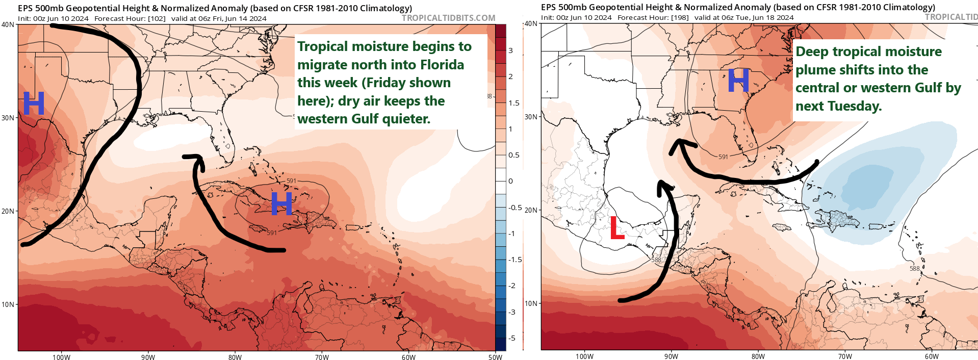
Here’s the basic, high level meteorology of how things will begin to unfold. First, a trough of low pressure in the upper atmosphere is digging into the Eastern U.S. this week. What it will begin to do is draw moisture that’s been percolating in the western Caribbean and Central America northward. As high pressure builds east across Texas and into Louisiana, the focus of this moisture plume will be over Florida. Widespread daily rain and thunderstorms will begin to add up across the Peninsula. Eventually, high pressure may flip flop and end up over the Southeastern US, allowing the moisture plume to begin migrating west across the Gulf, soaking the Florida Panhandle, central Gulf coast, and eventually Louisiana or perhaps Texas.
Where is the rain going?
All modeling agrees that the Florida Peninsula will get doused this week. The models split rather drastically beyond this week. Some aim the tropical moisture more at the central Gulf Coast. Others push it to Texas. There’s very little agreement or consistency in the modeling on this aspect of the forecast, so for now the rain focuses on Florida and by next week we’ll be watching elsewhere.
The exact placement of high pressure will help orient the moisture plume, which is why it’s a bit soon to say what the second round of this does. This is in some ways like forecasting where exactly an atmospheric river will make landfall on the West Coast. You know that there will be a whole lot of moisture coming, but is that going to Texas? Louisiana? Mississippi/Alabama? We don’t know yet.
Will we see a tropical storm or worse out of this?
Most likely no, but it cannot be entirely ruled out. Several model runs on several different models, along with multiple ensemble members on various models have been showing some low-end development. The trouble is that the consistency and persistence of it is far too volatile to lend any specific outcome credibility. This is not a total surprise for June; storms in June are most often sloppy. About 70 percent of all named storms in the Gulf in June end up remaining tropical storms, while 30 percent have become hurricanes. As of now, we’ve got no reason to think a well-organized tropical system will come from this.
It’s probably just going to be rain in Florida then, so it’s not a huge deal, right? Incorrect.
Moisture plumes traversing record warm Gulf of Mexico sea-surface temperatures do not exactly make for optimal combinations anytime of year, let alone June. This moisture has some teeth, and we’ve seen this reflected in some of the maximum precipitation forecasts showing up on operational models. These have ranged from 15 to 25 inches in some cases between about Louisiana and Florida. That would be a lot of rain for anyone. Since we want to focus on the next week, looking at Florida tells the story. Maximum rain forecasts are basically 8 to 20 inches in the southern half of the Peninsula.
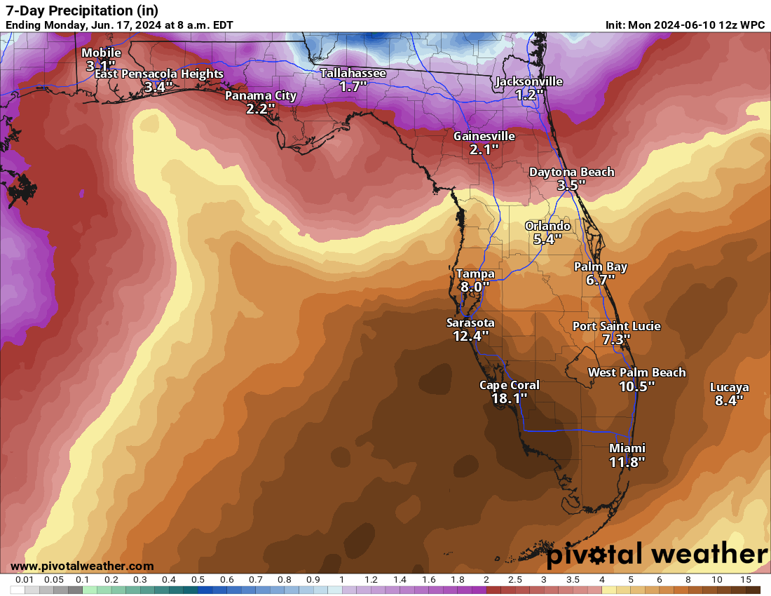
While there has been burgeoning drought here, anytime you get this much rain, it causes problems. I would expect flood watches and other notifications to get hoisted this week. If you’re planning a trip to South Florida, all we can tell you is to be prepared for more storms than usual and have some indoor plans setup, especially as this week progresses. And have a way to receive weather alerts.
Elsewhere, no other tropical concerns exist at this time and our focus will be entirely on this Gulf mess through the week.
I’ll take high pressure systems this summer over the alternatives
Thats how it was last year but some wanted tropical weather given the drought problem
Yeah, I can see their point of view. That was no fun, all that heat. All those poor trees.
There’s just so much fuel out there in the Gulf, we need some kind of protection. It won’t take much for something rather nasty to spin up.