See below for an update on Monday’s severe weather risk.
We’re coming to you on a Sunday evening to table set the week ahead. While we continue to check on eclipse forecast data, the bigger story in the meantime will be a major storm this week that brings a later season bout of winter to New England again. We explain what’s up there, as well as the latest forecast info on April 8th’s solar eclipse.
Headlines
- Severe weather possible from the Southern Plains into the Mid-Continent and Ohio Valley tomorrow and Tuesday.
- A late season winter storm may bring major winter storm impacts to portions of New England and New Brunswick later Wednesday into Thursday.
- Eclipse forecast cloud cover continues to look most pessimistic south and most optimistic north.
About that early spring… (UPDATED)
So, we’ve discussed how warm this winter was and how the northern tier really lacked a truly “good” winter. Over the last couple weeks, we’ve been making up some ground in parts of the North. And there is one more punch to be had in the Northeast this week.
The same storm system that will bring pockets of severe weather to the Mid-Continent and Ohio River Valley this week will move into the Northeast by later Wednesday and Thursday.
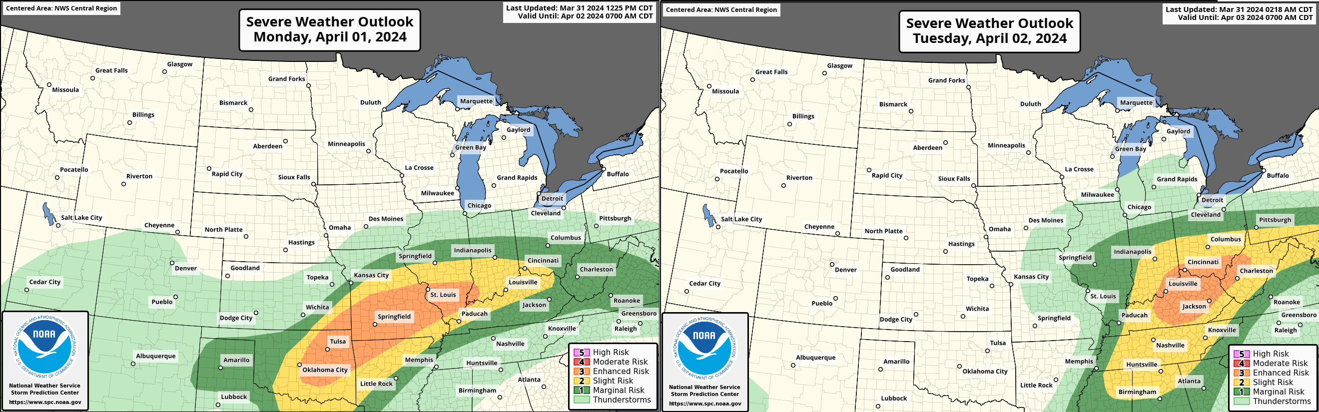
(UPDATE 12:05 CT Monday): The severe weather risk has increased today for portions of the Plains and Mid-Continent.
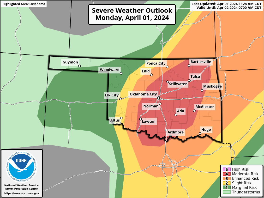
Oklahoma has been upgraded to a moderate risk (level 4 of 5) particularly due to the risk of large hail. But also because of strong winds and tornado risk as well. The greatest risk is east of I-35 late this afternoon and tonight. The risk shifts east after midnight. Not to be outdone, the enhanced risk (level 3 of 5) has also been expanded to include more of North Texas (including the DFW Metro) and more of southern Indiana, beyond where it had been drawn yesterday. Tuesday’s severe risk is mostly in place where it had been yesterday, though expanded some into Tennessee.
While the tornado risk generates the most buzz, that risk is a little more challenging to pinpoint today. The hail risk is very significant. Baseball or softball size hail is possible, if not likely in some storms today across eastern Oklahoma.
Previous outlook: The severe weather risk will bring damaging wind potential and large hail, as well as isolated tornadoes to areas from eastern Oklahoma across Missouri, including St. Louis tomorrow, and into the Ohio Valley Tuesday. Both Chicago teams have their home openers on Monday, so we’ll see if they get the games in. Tuesday could be a bit of a mess as well farther east for those of you in the fantasy baseball realm.
Anyway, as this storm marches east, it will deposit about 1 to 3 inches of rain across the Midwest and into northern Appalachia. Low pressure blows up over the Great Lakes, and as it slides east, it is going to encounter a setup in New England that is absolutely ripe for a springtime winter storm mess. Cold air funneling south initially out of Quebec and then out of the northwest as the storm moves offshore will allow for a rain, sleet, snow slopfest across the region.

This storm could differ from the last significant winter storm with the axis of heavier snow a little farther south. I also wouldn’t be surprised if this is a more elevation-driven play in terms of totals (where the higher elevations get the greatest snow), unlike the previous storm. The current thinking is that the greatest odds of heavy snow are most likely from southern New Hampshire and Vermont into western Maine. Snow and/or sleet will be possible down into parts of northern Massachusetts as well, north of the Worcester area. This could be some very heavy, wet snow for parts of southern New Hampshire and southwest Maine in particular, from Keene and Concord to Lewiston.
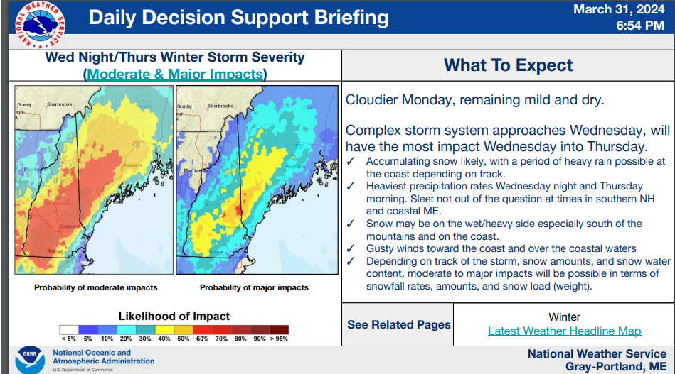
It’s still a bit too early to unleash snow maps and the like, but suffice to say, significant amounts are possible in these areas for April. Snow will expand north and east across Maine and into New Brunswick, with heavy amounts possible in those areas as well.
South of the wintry weather, look for the potential for heavy rain and flooding in spots. Again.
Eclipse forecast update: Good north, less encouraging south
Let’s start first with an update on afternoon rainfall probabilities for next Monday the 8th.
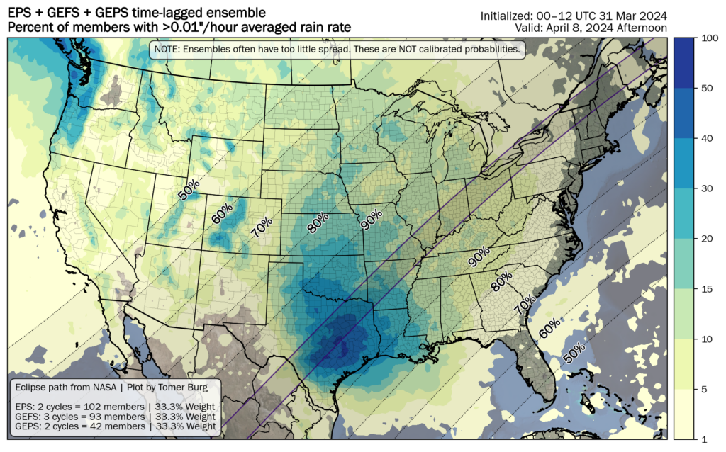
For those of us like me in Texas, this is not at all what we were hoping to see. We’re still a week out, so a lot can change, and keep in mind that probability of rain does not necessarily mean it will be overcast at the time of totality. But, this is not encouraging.
The cloud cover forecast ensemble mean from the National Blend of Models (NBM) shows fairly high probability of clouds in Texas up through the Mississippi Valley. As you go north of there, the odds start to drop off.

Again, a lot can change, and timing is literally everything with respect to a solar eclipse. A slight shift in timing of a storm system or track will lead to considerable impact changes on the ground. But, sitting here today, I feel least optimistic about Texas and most optimistic about Canada and the Great Lakes. If I’m picking a place right now, it’s probably like Watertown, NY or something. But this is a moving target, so watch for changes through the week, including how we’d characterize the cloud cover in the southern part of the path. Scattered clouds are doable, whereas overcast is not. We’ll watch for that later this week. We’ll have a quick update on this for you Tuesday and a more thorough update Thursday and Friday into the weekend.
*slopfest*
love that!
😄
Thank you for the eclipse forecast discussion. I need to decide whether to cancel a hotel reservation by Wednesday. The Austin weather service office says in their discussion that models indicate a Pacific front will come through Sunday, but another low will come in behind that keeping things messy.
Thanks for this! Me and two bffs are going to head from NJ on Saturday morning to where the prospects are best.
Wishing everybody clear skies. The shadow of the moon waits for no man.