Happy Tuesday. Today we look at the ongoing significant severe weather risk, an update on the snowstorm for New England (and Canada and parts of the Great Lakes), and a quick update on the eclipse outlook.
Headlines
- A moderate risk (level 4 of 5) for severe weather is posted for portions of Indiana, Ohio, and Kentucky today, with significant tornadoes possible if the atmosphere can realize its full potential.
- A risk of severe weather, including significant tornadoes extends south of that area today into northern Mississippi and Alabama.
- A major snowstorm will impact portions of the Great Lakes and New England with 1 to 2 feet of snow in spots.
- Solar eclipse outlook continues to look rather pessimistic in Texas, questionable north of there to the Midwest, and optimistic for New York, New England, and Canada.
Moderate severe weather risk for the Ohio Valley, but don’t sleep on the South
Yesterday saw a moderate risk issued for parts of Oklahoma. There were some social media posts about extreme tornado risk that seemed a bit excessive. Hail was the primary concern with yesterday’s severe weather, and in the end there were about 20 significant hail reports, with over 100 severe reports to go with it versus about 3 tornado reports. Interestingly, a lot of the bigger hail reports ended up south of the most serious concern area. Texas checked in with the majority of the significant hail, including a 3 inch report just south of Denton.

Today, the threat of severe weather marches eastward toward the Midwest and Ohio Valley. A moderate risk (level 4 of 5) has already been hoisted for portions of Ohio.

This is surrounded by a pretty healthy area of enhanced risk (level 3 of 5) that includes Nashville, Birmingham, Knoxville, and Charleston, WV.
The headline risk today is tornadoes, as the environment will be capable of producing supercell storms that could include developing long-track tornadoes — IF there is enough instability available. The current moderate risk is meant to cover that. The question is whether or not the warm front can push far enough north to destabilize that area. This is what we call a conditional risk. In other words, if instability and the ripe, really warm and humid air mass doesn’t press far enough north, you end up with probably a minimal outcome. However, if that beefier instability realizes farther north, the environment ends up being a powder keg for severe weather. Hope for the former, prepare for the latter.
To the south, I noted the enhanced (level 3 of 5) risk extending into Mississippi and Alabama. Despite the Ohio Valley being the main area to watch right now, don’t sleep on the South. In their morning discussion, the SPC highlights the potential for a risk that may need to be upgraded in some areas later today.
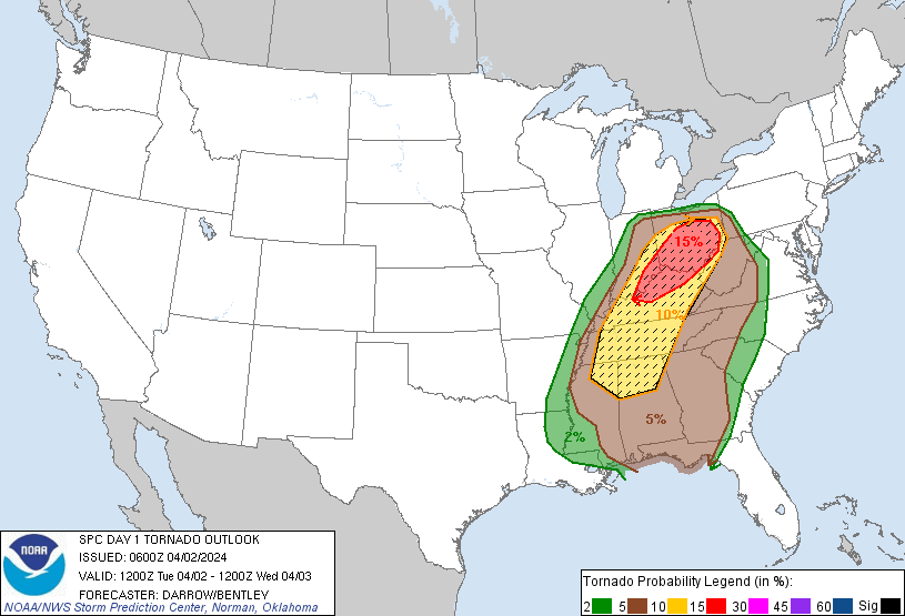
In addition to tornadoes, the threat for damaging wind and large hail continues today as well. Heavy rain and localized flash flooding are also possible.
Impressive April snowstorm for portions of the Lakes, eastern Canada, and New England
A major winter storm for spring is still in line to impact much of New England beginning later tomorrow and into Thursday. It starts tonight in the Midwest, with major to locally extreme impacts possible across northern Wisconsin and the U.P. of Michigan.
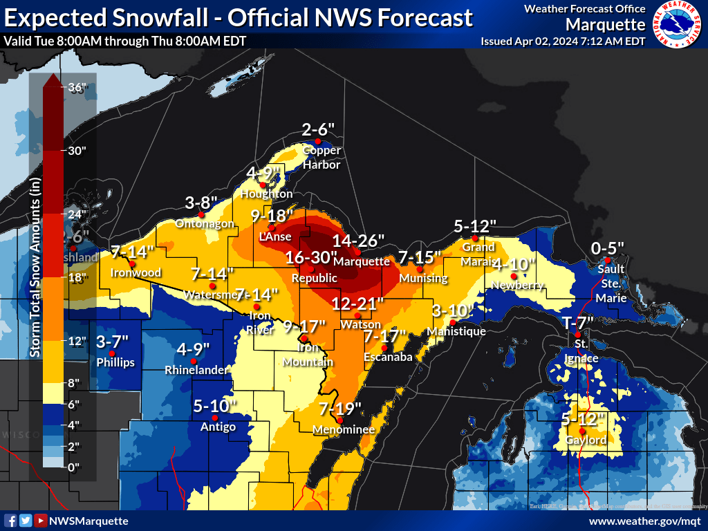
Lake enhancement off Lake Superior really helps here, cranking out north of 2 feet in spots in the terrain southwest of Marquette.
As the storm moves to New England, snow totals continue to look look fairly impressive, particularly given the calendar.
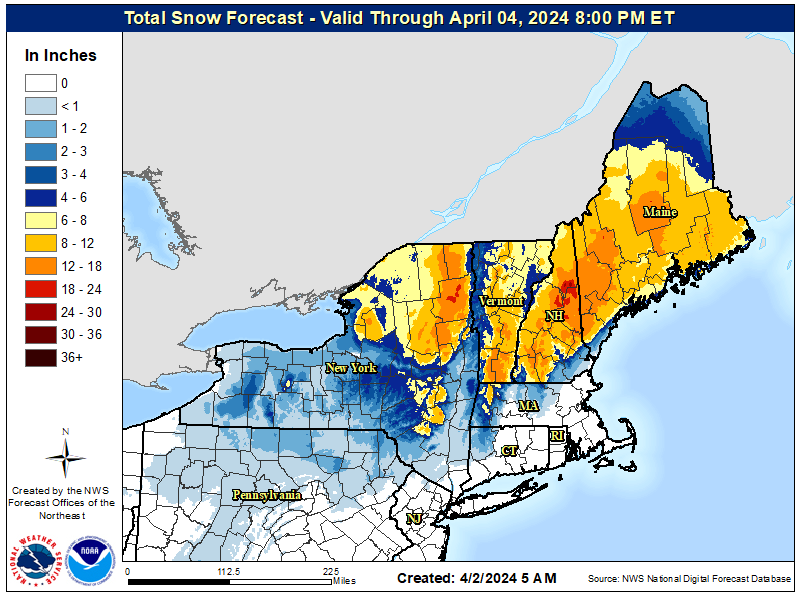
Forecasts show anywhere from 8 to 12 inches over a wide area, with higher amounts likely at higher elevations. Again, this will be a different animal than the previous storm last week that brought snow to similar areas. Additionally, the snow “load” will be significant given the time of year. This will be a heavy, wet snow and when combined with gusty winds, trees and power lines do have a chance to fall in spots.
Snow will also expand into Canada with some portions of southern Quebec (Sherbrooke in particular) and New Brunswick taking the brunt of it. Snow will also impact portions of Canada west of there, with perhaps 10 to 20 cm or more of it for Ottawa and much of the Ottawa Valley. Snow should also expand up through the Gaspe Peninsula in Quebec. Snow forecasts are a little more challenging south of there, but some accumulation is possible for Prince Edward Island and significant accumulation perhaps in the Cape Breton Highlands. The rest of Nova Scotia should see snow changing to rain.

The snow should taper or become more showery on Friday, but there may be some lingering flakes in spots even into Saturday! Expect locally significant travel issues in these areas.
Eclipse update: Northeast and Canada looking best
Things have not changed much today, which is unfortunate news for those of us in Texas.
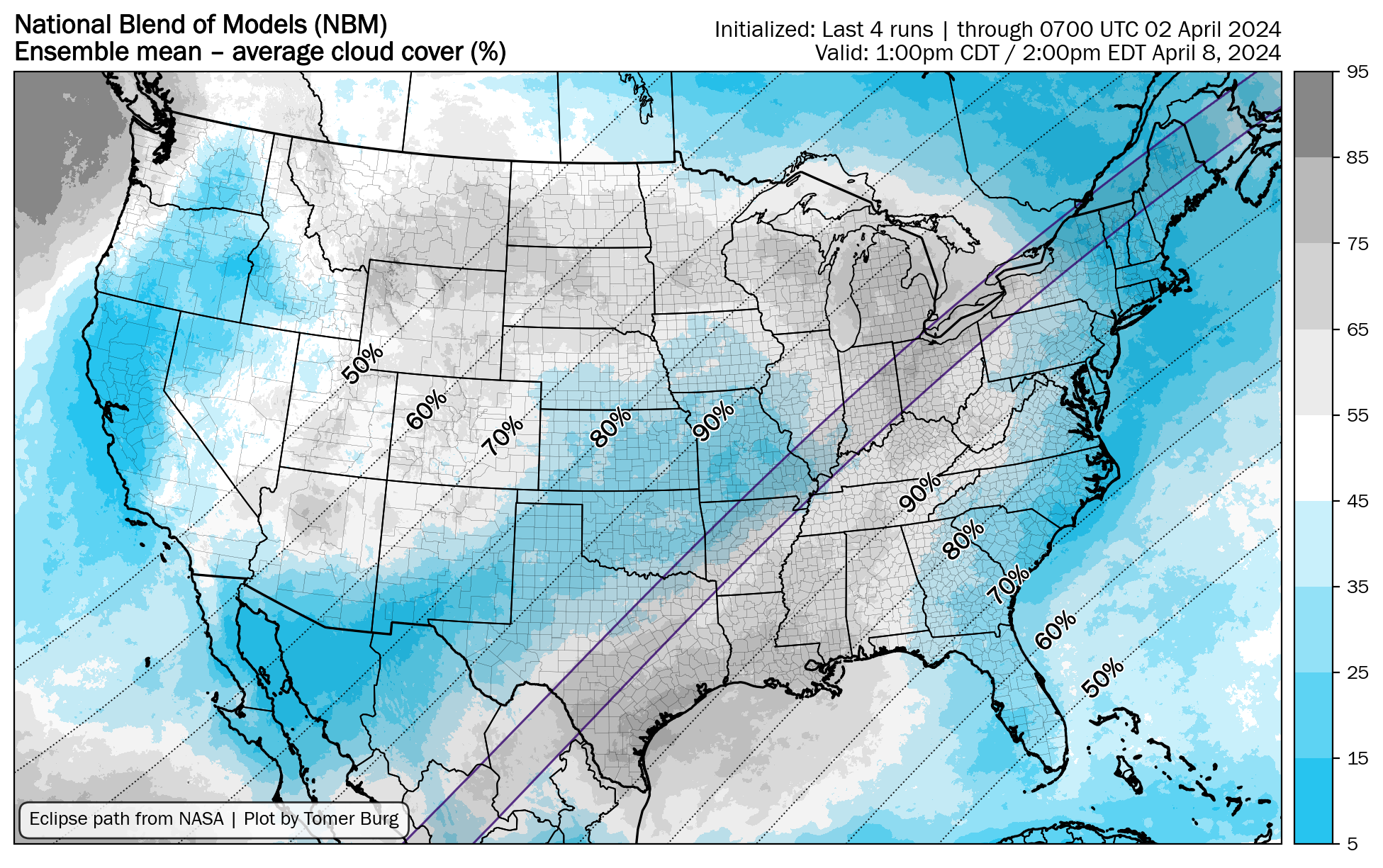
There may be a gap in the clouds ahead of the storm over Texas, so portions of Missouri, southern Illinois, or Arkansas may, may have better luck. Additional clouds may infiltrate the Midwest, but that’s lower confidence than Texas right now. The best picks as of today? Watertown, NY, Burlington, VT, Houlton, ME, and portions of Quebec and New Brunswick. Will this change? Probably, but it’s getting a little late in the game for Texas I fear. That said, one scenario for Texas involves timing more than anything. If the storm can slow up 3-6 hours and we end up with just some thin high clouds over Texas, that wouldn’t be the worst thing in the world. So, there are ways. It’s just getting a little harder to view it optimistically. More tomorrow.
Given that your mission is to eliminate hype and anxiety, why do you name your newsletter after the worst part of a hurricane? Day after day we get reminded of potential disaster via its name when we should instead, by your stated purpose, be informed of conditions by people whom we can trust to have level heads and no need for an eyeballs-for-ad-dollar-click-bait style of communicating. Please consider a different moniker.
The name of the site is the least of its issues. The guy who writes for it has no concept of the word brevity. You really have to be interested increasingly in the technical aspects of weather to get anything out of it. Unless there’s something major, weather wise, going on in the country, or some odd phenomenon, it’s exhaustive to get through for the casual reader. It didn’t start out this way last June, but I’m more interested in hurricane season anyway. That’s why I’m probably going to skip reading some daily write ups, unless it’s something big around the country that’s gone down.
that map is a nail biter. I decided over a year ago to not get set on a location, knowing spring weather in eastern North America is a roll of the dice. Still a ways to go before the party starts, though.