One-sentence summary
While we continue to keep an eye on a couple robust looking tropical waves in the Atlantic, there has been no added support or reason to believe these are any likelier to develop this week than it appeared last week, which is to say chances are low.
Happening now: Do the wave
Looking at satellite this morning, we have two pretty distinct features in the Atlantic. If you did not know better, these might look somewhat likely to develop.
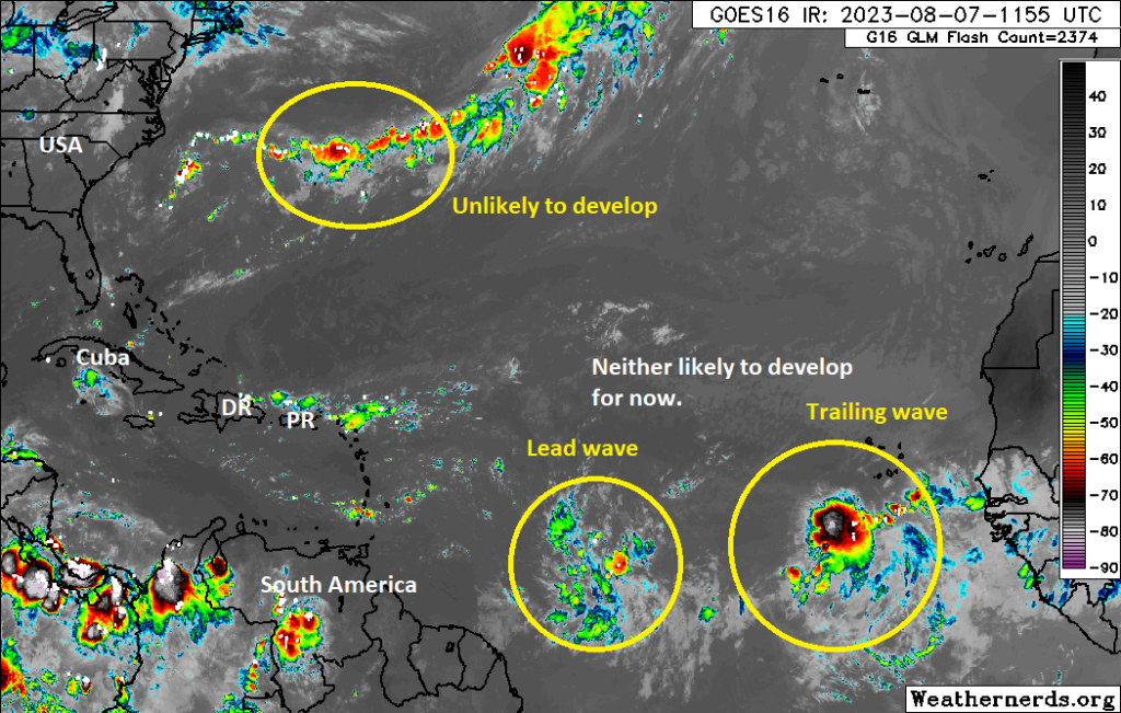
But you read our site each day, so you do know better! And what I can tell you about things today is that these remain just some relatively bulked up tropical waves. No development of these waves is expected over the next 5 days as they continue marching to the west. The leading wave should arrive in the Antilles by Wednesday, bringing bulked up rain chances with scattered showers and thunderstorms to many of the islands. The trailing wave may or may not make it to the Caribbean.
Wind shear is going to remain rather hostile across many key points across the basin, including in the Caribbean, Gulf, and southwest Atlantic.
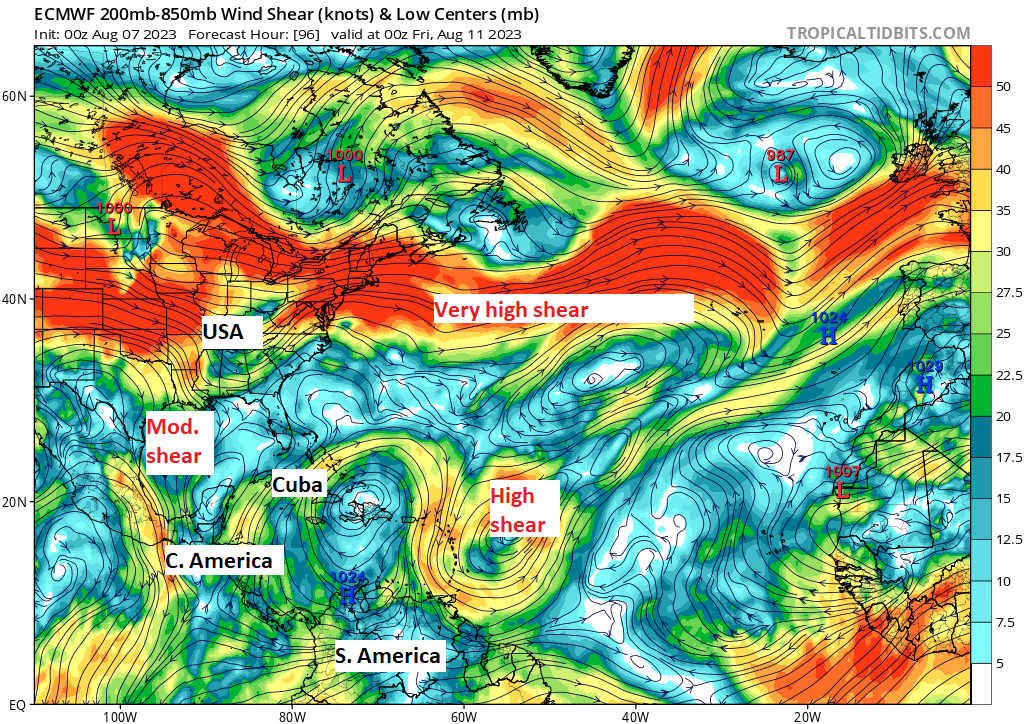
This should act to keep any development chances of these waves very much in check over the coming days.
The medium range (days 6 to 10): Development odds remain somewhat squelched
There are a couple things to watch in the medium range but none that I think are particularly likely to develop. First, the wave entering the Caribbean early in the period that will struggle may have some potential to try and organize itself as it comes west if it can escape some of that shear above. But honestly, that’s entirely based on history. Because the models are not having it. Here’s a map that roughly shows how much uncertainty there is in the Euro ensemble (50+ runs of the same model with tweaks) forecast of sea level pressure with this wave as it moves toward the northwest Caribbean and Gulf.
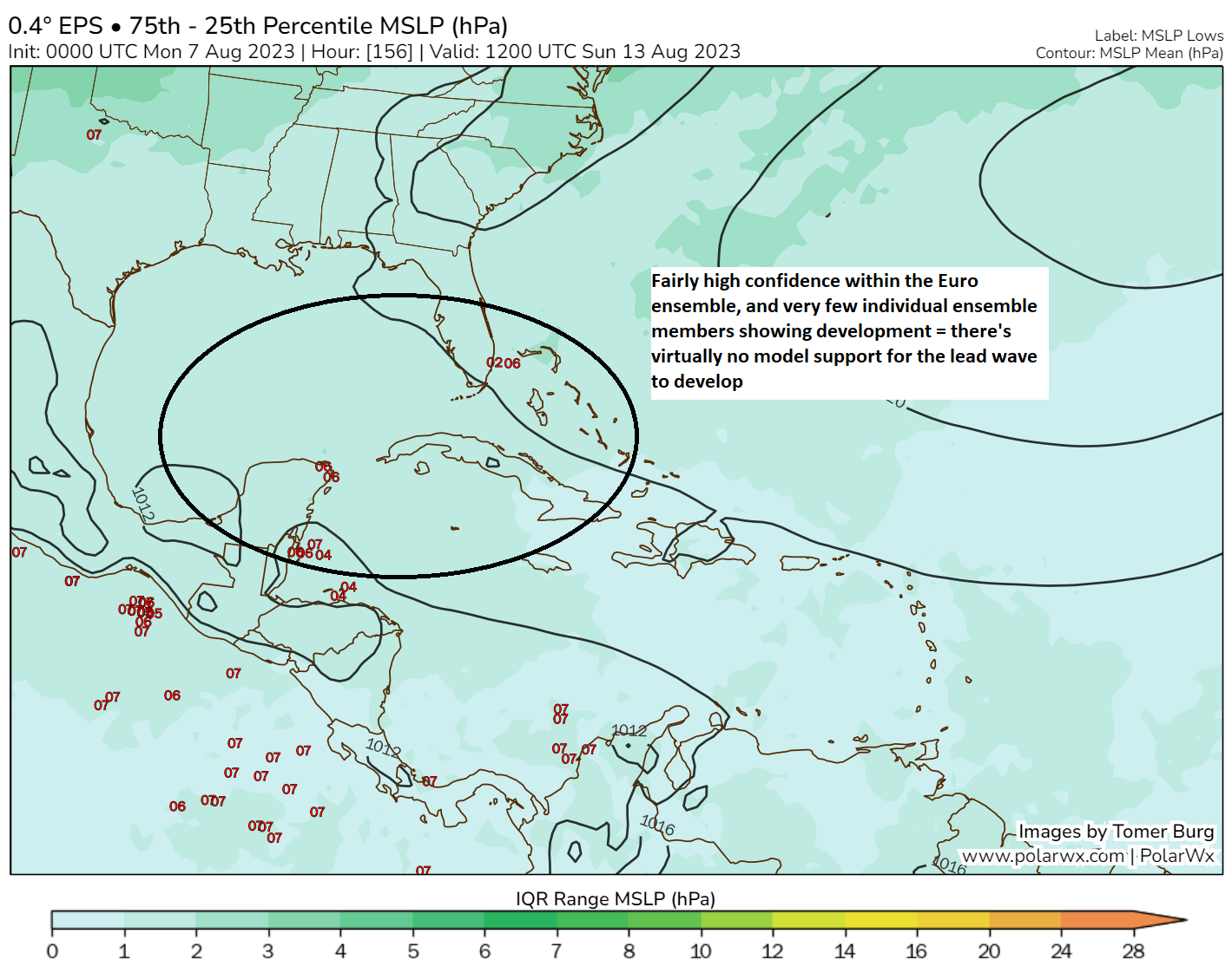
There’s not much there. If there were higher uncertainty (in this case, a meaningful cluster of individual ensemble members showing development), these colors would pop more. To me, this indicates that within the ensemble spread of the 51 members from the Euro, there is not a ton of volatility. If a tropical system were likely, you’d expect volatility here. Since we don’t see this, it’s indicative that modeling senses a hostile environment toward any tropical development. So, yes, keep an eye on it, but odds seem to favor nothing over anything else.
There may be an additional wave off Africa to look at or perhaps the trailing wave in the Atlantic in the near term can try something, but all of these features are likely to have some headwinds inhibiting their organization.
Fantasyland (beyond day 10): I guess we can keep an eye on the Atlantic?
Trends this season have been very, very clear cut in modeling. A system shows itself as possible around days 10 to 13 or so, it holds in the modeling, a development area gets highlighted, and then it finds a way to fail. Now that we’re pushing through mid-August and toward late August, I don’t want to get lulled to sleep. But admittedly, I can’t help but wonder if we’re trending toward that potential again. There are some signs of a wave forming in the Atlantic in the 11 to 15 day period, but exactly how and where are up for debate within models.
So for now, we’ll say that development odds in the “fantasyland” portion of the forecast are maybe a little higher than in the medium or near-term, but I would not classify the odds as “high” by any means yet. That is good news in mid-August.
Love your work and appreciate your tone and humor. Is there a glossary for weather term definitions you can recommend? Or does this site or SCW have one (hint, hint)? I’m talking wind shear, global wet bulb temp, Euro, etc. Just a “pinned” page that some of us and new readers can refer to. Thanks!
That’s a good thought. We don’t have one, but perhaps we need to consider that. I try to explain most things in the post, but that can certainly get tiring after awhile (though I’ve improved my ensemble explanation from one paragraph to one sentence!). I’ll just say this thought is noted. Thank you!