Today we dive into Colorado State University’s hurricane forecast for 2024, which continues to add to the narrative for this season. Put simply: It’s likely to be busy, if not very, very busy.
Headlines
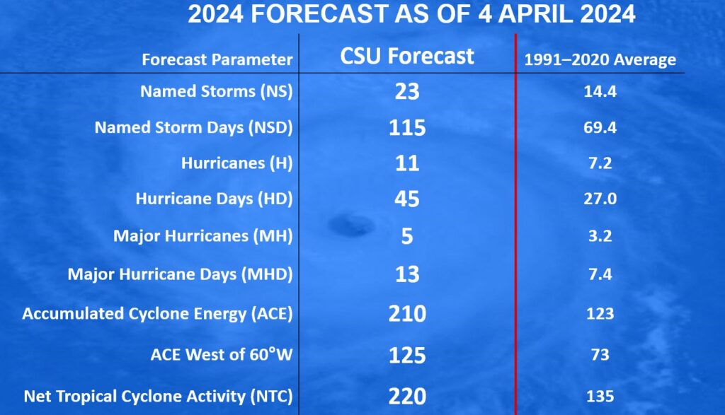
- Colorado State’s seasonal forecast for Atlantic hurricane season is their most active preseason forecast since they formally began this in the 1980s.
- They call for 23 named storms, 11 hurricanes, and 5 major hurricanes.
- It would easily rank in the top 10 for most active seasons if it verifies.
Why Colorado State?
Colorado State’s seasonal hurricane outlook is sort of a major highlight on the meteorology calendar for those of us who often deal with tropical weather. The first question I’m often asked is why on earth are we getting hurricane outlooks from Colorado State? Well, through the years, they’ve amassed a ton of research into tropical weather, beginning with Bill Gray, who began the process there in the 1970s. His research set the basis for a lot of what we understand about longer-term views on hurricanes and cycles of hurricanes. He just happened to work at CSU, and thus, they’re generally the leading experts.
Are they good at this?
They aren’t bad, and if anything, they’ve gotten a whole lot better over the years.
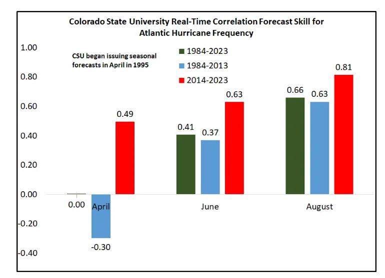
What really stands out to me is how much their April forecasts have improved in the last decade. I remember 2006, the year following Katrina, Rita, Wilma, etc. and how everyone including CSU called for an active hurricane season again. And it busted pretty badly. Since then, we’ve added so many new tools and methods to look at this stuff, and thus we’re seeing the fruits of this realized in improved outlooks. Are they perfect? Absolutely not, but they’re skillful. Last year, they called for a slightly more active season despite an El Niño, which historically produces less active seasons. They were correct.
What does their forecast mean?
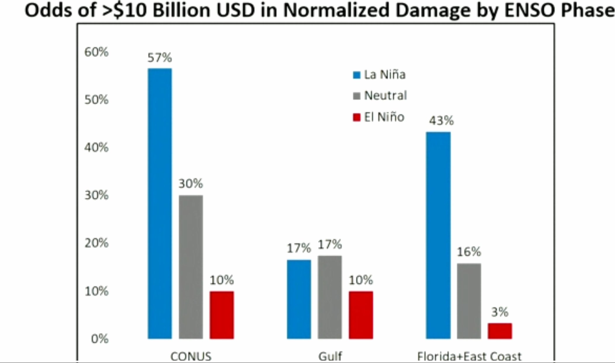
It adds to the growing body of evidence that the upcoming hurricane season is likely, if not highly likely to be quite active. Their forecast accumulated cyclone energy (ACE) is over 200, which would constitute a “hyperactive” season and be the most intense since 2017 (Harvey, Irma, Maria, etc.). It confirms basically everything we’ve discussed this year in our monthly posts on hurricane season: The Atlantic is exceptionally warm, we are likely heading toward a La Niña this summer and fall, and the historical combination of these factors would likely produce an extremely active hurricane season, perhaps one that is more active closer to land than we’ve seen in the last couple seasons. As you see above, the odds of a multi-billion dollar season in terms of damage is much higher in La Niña years nationally. Though, do take note of the Gulf Coast risk being about unchanged. Given the current state of the insurance market, this is an obvious concern this year.
Sure, but what does their forecast mean for me?
Nothing specific right now. We have no way of knowing when, where, and what will hit this summer. We just have data that says it will probably be busy. What it should mean for you is that this is the time to prepare for the upcoming season. On our preparedness page above, we have links to a bunch of local emergency management pages across the country that can give you advice or tips more specific to your area. But at a high level: Have a plan, build a kit, and review documentation to make sure you’re up to date on insurance. Preparedness is a critical element during hurricane season. We’ve seen too many examples of people being on their own for a period of time after a disaster, so the more you do now to prepare, the better off you’ll be if this is the year.
Many of these forecasts cite warm ocean water as a contributing factor. Why are the oceans so warm and what’s it going to take to cool them down (if that is even possible).
There are a number of theories about what’s happening. A change in shipping regulations that has reduced sulfur pollution, climate change, and some other stuff. No one is 100% sure what’s behind it and if and when it will cool back down. It seems to have peaked, but that’s speculative on my part. But whether or not this is a new normal, I don’t know. An active hurricane season could help stir up colder water below the surface, but I’m not certain it would appreciably alter the fundamental causes of the warm water. In other words, any cooling would be temporary. But it’s certainly disconcerting.
Based on what I’ve seen it’s due to numerous factors. Decrease in sulfur aerosols that help block sunlight from efficiently warming the surface, weak trade winds in recent months (strong trade winds produces higher waves which keeps the water upwelled and churned up. With weak trades the ocean is calmer, allowing for more efficient heating from the sun), and of course the background rising trend in temperatures from climate change.
Some solid bursts of strong trade winds would help attenuate the warmth, but I’m nowhere near qualified to opine on if and when this will happen.
Hi just wondering what you meant about the Gulf Coast risk being unchanged? Is that information in the actual report? Thanks for the clarification.
So what I am saying there is that Florida and the East Coast have a much higher risk in a La Nina, the Gulf is only slightly higher in La Nina than El Nino. For all intents and purposes, it’s unchanged risk whether we’re in La Nina or El Nino, so that’s locally not a huge Gulf factor.
The report said that warmer spring SSTs “tend to force a weaker subtropical high”.
I read that as being a second cause of a lack of wind shear, separate from (and in addition to) La Niña. Would that be correct?
🤔…
💗 The Eyewall!
🌬 ⚘⚘⚘
I imagine that wouldn’t hurt matters in the shear department. Would probably also influence steering to a degree too.
Does Colorado (or anyone else) ever issues a prediction on the arrival of conditions for tropical activity? I know we’ve had the rare pre-season storms, as well as some active Junes and Julys. I’m curious if these predictions of hyperactivity mean that some early activity may be possible too.
Good question. They do not to my knowledge. I think it can be implied with an outlook this busy you would be more likely to see activity kick in by May or June and stay fairly sustained or come in bursts.
Is it November 30 yet?