Recent rainfall and flooding in Dubai of all places has set off a firestorm of misleading, incomplete, and even some bizarre theories on social media. How did this actually happen? Turns out it was a pretty straightforward forecast, and no one should be surprised that this was a major event. It just happened to also hit a place that has a lot of people, rarely sees events of this magnitude, and happened to mention that they also seed clouds, which is unlikely to have done much to affect the outcome.
Headlines
- Dubai was recently hit with a storm that dumped copious amounts of rain on the desert megacity, arguably their heaviest rainfall since at least the 1950s.
- Over 6 inches of rain fell in 24 hours, which equates to over 2 years of average rainfall for Dubai.
- Dubai captured the headlines, but the rain also impacted places like Oman, Bahrain, Saudi Arabia, and Qatar.
- The event was extremely well-forecast and captured by modeling ahead of time.
- Cloud seeding likely contributed a little to rain totals, but should not be attributed as the cause of the flooding.
What happened?
An extremely anomalous weather pattern established over portions of the Persian Gulf and Middle East this week, featuring a rather deep upper-level trough over the area. This type of pattern is what typically brings unsettled, wet weather to mid-latitude locations.
This trough seems to be cut off from the jet stream, a condition that also isn’t necessarily uncommon in many places, and historically it does lead to localized prodigious precipitation totals in spots under the right conditions. So while the placement of this weather system was a little strange, the outcome (scattered heavy rain and flooding) was not.
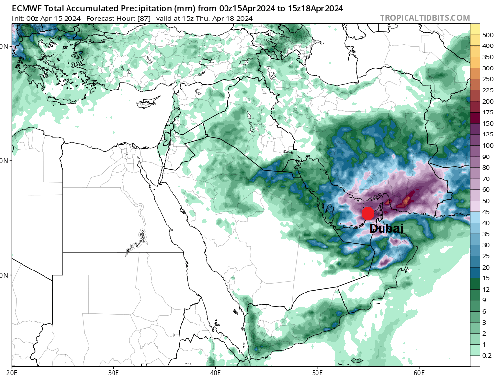
Model forecasts were all over this. In fact, the forecast from Sunday’s European model (shown above) pegged Dubai for roughly 4 inches of rainfall between Sunday and Thursday, with most of it falling Tuesday. Nearby areas showed bullseyes of 5 to 6 inches of rain over the Strait of Hormuz and into portions of southeastern Iran, as well as in Oman (where over 15 people died from flooding). So this was not a surprise storm by any means. Unusual and historic, certainly, but not a surprise from a modeling standpoint. This is about as well telegraphed as you could hope for.
Various other factors likely helped amplify the rainfall over the UAE, Oman, and Iran. The location of this region in proximity to a number of features that usually align with heavy rainfall, and the presence of precipitable water values (PWAT) that were likely over 200 percent of normal made this basically a straightforward case of an area that would get hammered by heavy rain.
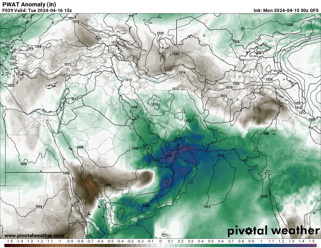
Precipitable water is essentially how much moisture is available for rainfall. If I saw this 2 to 3 days ahead of time over a place many of you will be more familiar with, like Houston, I would expect flood watches and warnings to be imminent.
The bottom line: An anomalous pattern produced an anomalous result, and nothing about it should have been a surprise given the forecast.
Did cloud seeding make it worse? Not really
If you read the above section, you can see that models were actually printing out 4 to 6 inches of rainfall over this area. Cloud seeding is a process where humans fly an aircraft into a storm and release a small amount of a harmless compound, typically silver iodide. The intent is to seed the storm with a few more nuclei for raindrops or snowflakes to form on within the cloud that will enhance precipitation downwind of the storm. This strategy has been practiced for years, all over the world, and almost always in arid areas where water is a vital and precious commodity. Every little bit helps these areas, so when storms happen, it is common for cloud seeding to occur. Typically, you could see rain totals increase by 5 to 15 percent based on the project. Each one has mixed results, some with more rain, some with little to no increase in rain.
So doing that back of the envelope math, if you assume the UAE generates cloud seeding results on par with historical averages, you would be looking at roughly 0.3 inches to 0.6 inches of additional rainfall. When dealing with 6 inches of rain in an arid location that lacks the ability to handle so much water, that’s primarily background noise, a rounding error mostly. Cloud seeding certainly did not cause the storm, as we saw above. And historical results suggest it would have had minimal impact on the end results as well, other than providing just a little more water for an arid region. It’s like saying that the 538th home run by an unnamed baseball player that allegedly took performance enhancing substances was directly caused by the performance enhancing substance. That ballplayer would almost certainly have hit a deep fly ball or even a home run without the PEDs, but the PEDs just added a little whipped cream on top to nudge it out. The heavy rainfall was the cake, the cloud seeding was the icing. You’re still getting cake, you’re just getting a few more calories.
What else should we know?
We’ve seen a lot of heavy precipitation extremes in recent years all over the world, and as much as many folks don’t want to discuss climate change, you absolutely need to in this instance. Here’s a look at Persian Gulf and Gulf of Oman water temperature anomalies.
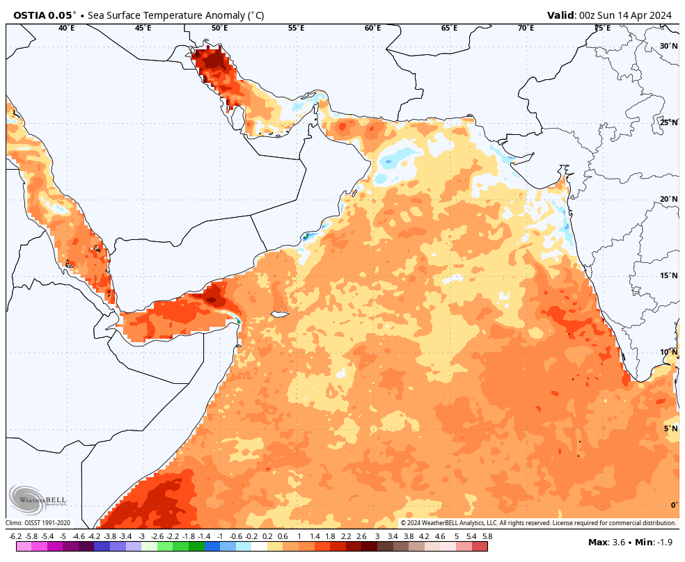
Given the Arabian Peninsula’s location, if you were to inject 200 percent of normal moisture to this area and got heavy rain, it was almost certainly influenced by the excessively warm Arabian Sea, Persian Gulf, and Gulf of Oman. No matter which direction the wind was coming from, you were probably transporting this warm, moisture-laden air into an already primed atmosphere. The end result was one of the worst rain events for an area in modern times. Our oceans are on fire around the world right now, and heavy precipitation extremes are increasing. The causes are more complex than a social media post or three could cover, but climate change is a significant player in it all. Expect to see more situations like this in the coming months and years.
i really like you guys. good info.
We’re in hot water ♨️
I remember a similar situation in El Paso, I think it was in the early 60s. It poured down rain one day for a short period of time, dumped about 5”. The effect was minimal because the terrain is mountainous. But it was noted by the community. I saw the runoff from the mountain in a gutter form and hydraulic jump across the gutter of an intersecting road.