In brief: Today we discuss flooding risks in Florida from a disturbance, potential Atlantic development next week, and Storm Amy in Europe. We also look back at Humberto’s rapid intensification to category 5 status and place in the context of recent news stories about Katrina and Rita’s 20th anniversaries and evacuation planning.
All the quick hits
Atlantic tropics: Florida
Happy Friday. We’ll keep the weather part brief today. First, we have two areas remaining on the map now.
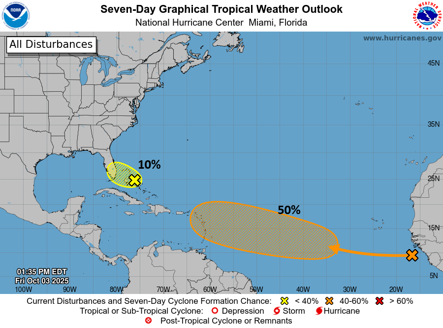
The area near Florida and the Bahamas remains unlikely to develop. It will, however, contribute to several days of rain chances on the Florida Peninsula. Flood Watches are now posted for the Space Coast and Treasure Coast.
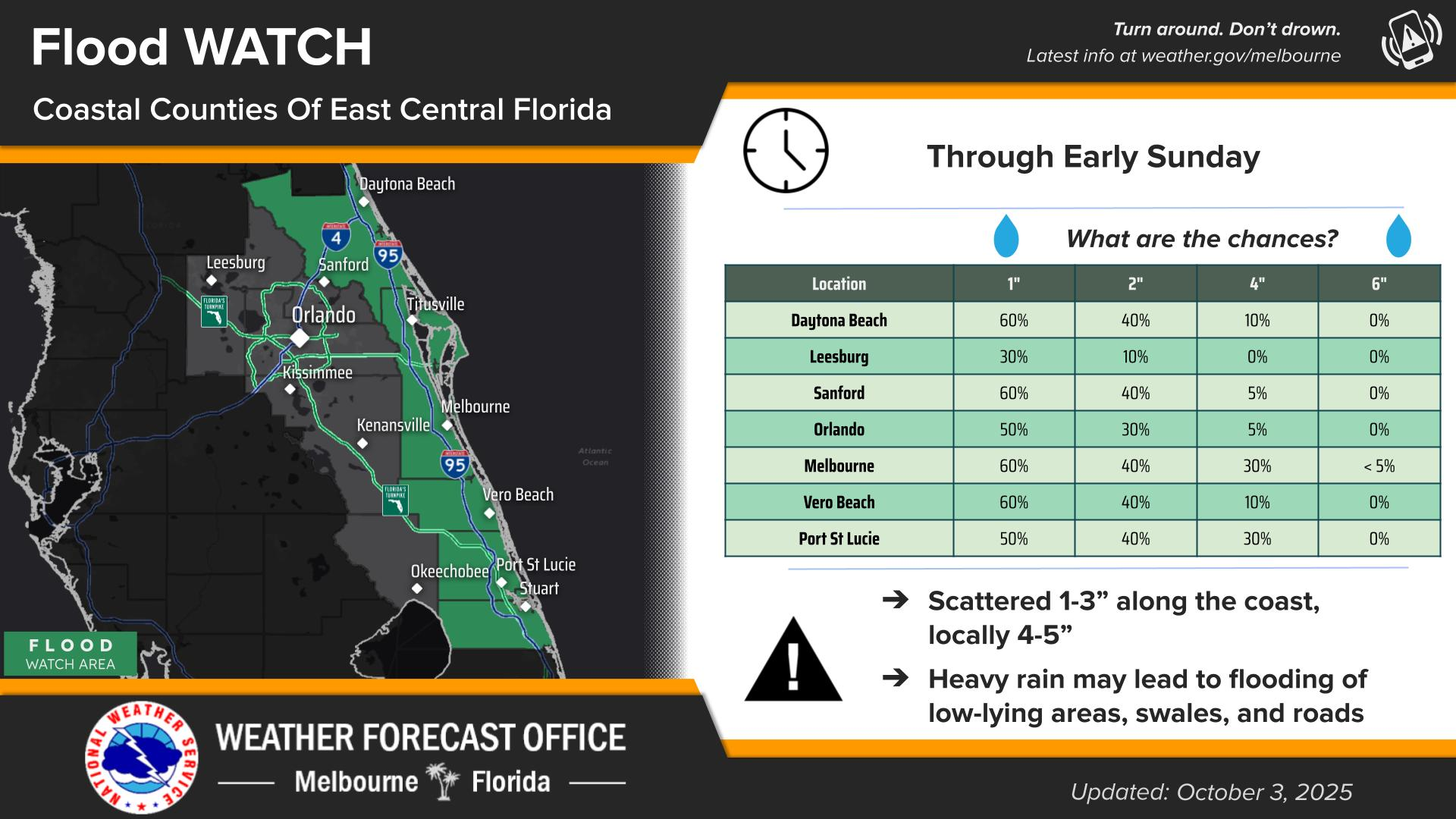
We also continue to see coastal flood watches and alerts posted from South Florida up into the Carolinas, including a Coastal Flood Warning in the Jacksonville area.
Heavy rainfall will add up to anywhere between 1 and 4 inches this weekend along the Florida coast. Urban flooding and flooding of low-lying areas is likely at times. And heavy rain may exacerbate coastal flooding concerns near places like Jacksonville.
Atlantic tropics: Next wave up
Looking out farther to the east, we have an uncommon late season Cabo Verde wave to watch over the next several days.

It surely doesn’t look like much right now, but the models generally support a slow development from this area as it tracks west over the next 5 to 7 days. Everything at this point is speculative. This will almost certainly turn north and out to sea eventually, but the question is where. Will that happen before or after it gets to the northeast Caribbean? If before, we’re all good. If after? Then we may be on storm watch in Puerto Rico and the northeast Leeward islands in about a week. For now, it remains something to watch but nothing we can really say much more about yet.
Storm Amy in Europe
The significant early season storm impacting the UK and Europe more broadly is blowing through the region this evening.
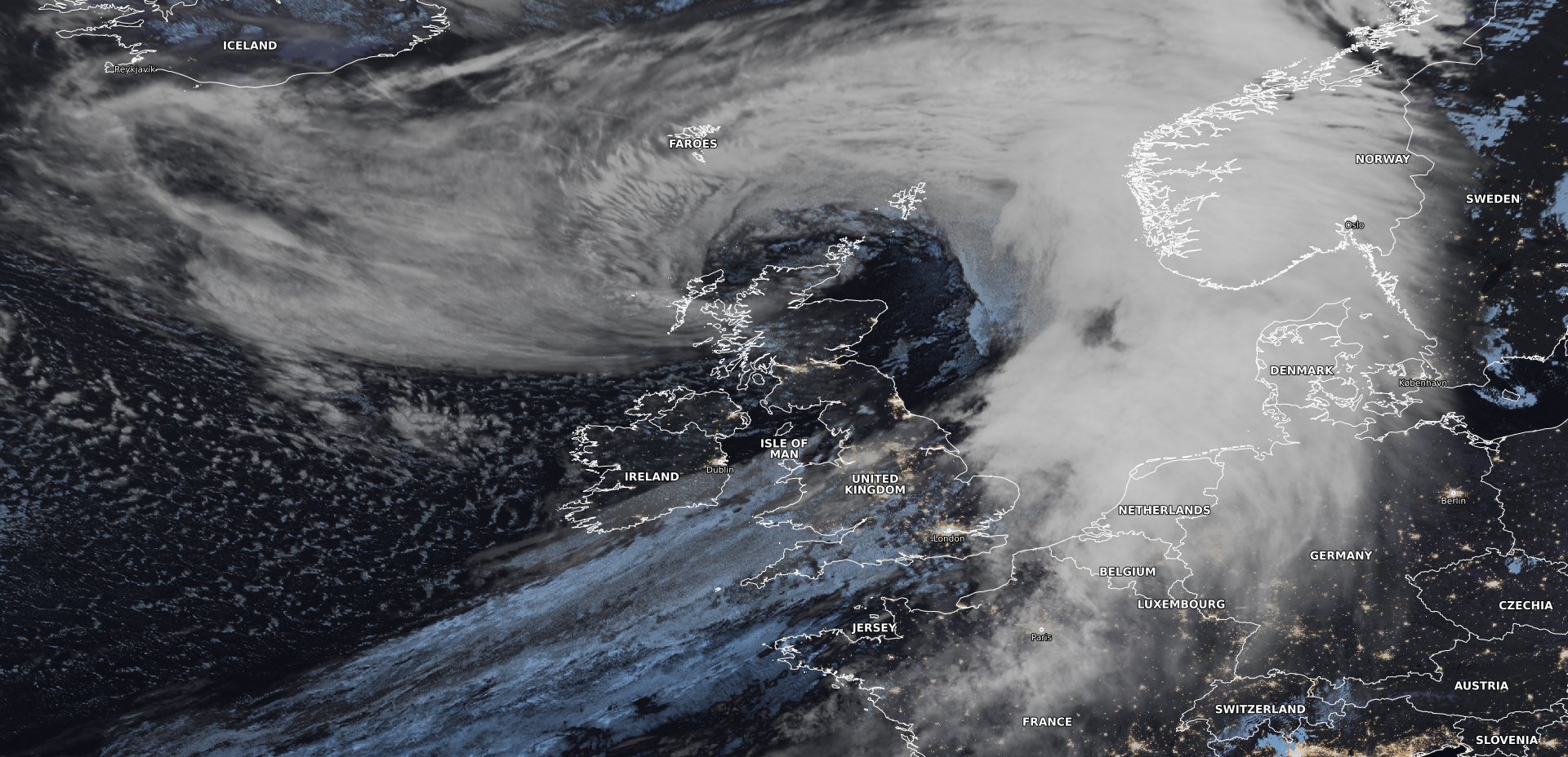
Per the BBC, the storm has cut power to 50,000 in the northern UK. Train service is on hold in Northern Ireland, and Glasgow’s Central station is closed through Saturday afternoon. Winds will continue across the UK into Saturday, even as most of the rain has pushed east of the region. Tiree, off Scotland’s west coast reported a 96 mph wind gust from the storm. Additional weather warnings pepper the southern portion of Norway, mainly south and west of Oslo with winds of 60 mph possible there as well. Conditions should begin to improve across most of the region later Saturday into Sunday.
Meanwhile, Imelda’s remnants continue to swirl in the open Atlantic. They will be gradually absorbed into the jet stream next week.
Looking back: Humberto’s intensification & applying its lessons to evacuation planning
Huumberto is now a part of Storm Amy in Europe, but it is probably instructive to look back at that storm, because there are lessons to take from its rapid intensification.
When Humberto was classified as a tropical storm on Wednesday, September 24th, the initial model spread of intensification showed a wide range of outcomes by Saturday evening the 27th, with most hinting at a Category 1 or 2 storm.
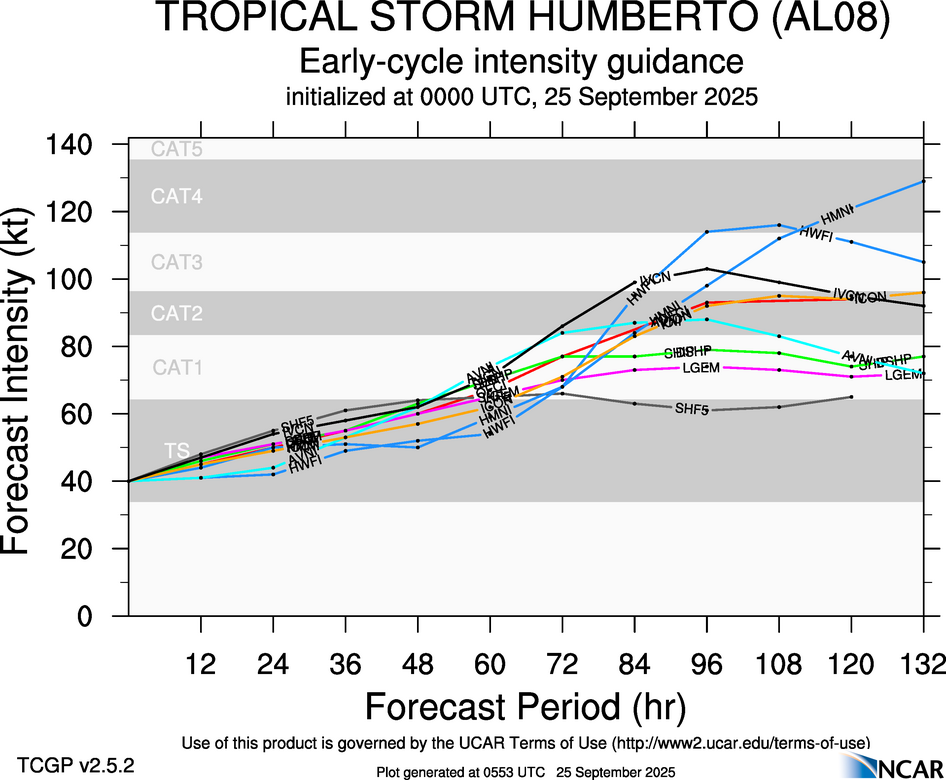
From the first NHC advisory, it showed Humberto reaching the cusp of major hurricane intensity (110 mph) by Monday afternoon. By the Wednesday night advisory, that had nudged up to 115 mph, a category 3 major hurricane. Per the NHC, “The official intensity forecast is in reasonable agreement with the simple and corrected model consensus, including the latest FSU Superensemble forecast.” The subsequent Thursday early morning advisory didn’t make any meaningful changes, nor did it indicate much had changed. By late morning, the NHC had gotten more bullish on intensity, pushing it up to 120 mph, with emphasis being placed on the environment it would be in. In other words, as a frequent consumer of NHC discussion information, I would read between the lines and say that the latest model data with both the HWRF and HMON showing category 4 risk by Sunday morning had some merit.
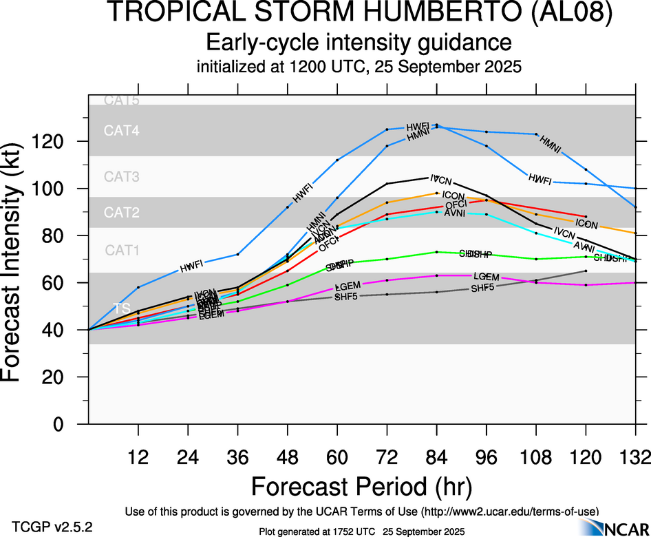
From here, the forecasts gradually went upward, reaching 125 mph on Thursday’s late evening advisory and 130 mph early on Friday morning. It then jumped to 145 mph by late Friday morning, in line with model guidance.
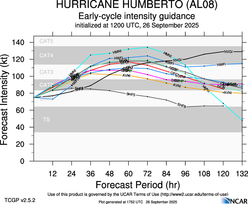
And the rest is basically history. Did anyone really expect Humberto would become a category 5 storm before Friday or even Saturday? Probably not. Did model guidance handle it well? It got better with time, as you’d hope. The NHC seems to have beaten most of the model guidance on Thursday into early Friday, and forecasters that read the NHC discussions (as all should) would have been tuned into their language being escalated. We will wait for the statistics to see just what did best during Humberto, but the NHC did a fine job raising the bar of concern with its intensity.
Now, given that Humberto was a secondary concern to Invest 94L and PTC 9/TD 9 at the time, it felt like this was all an afterthought. But I think it speaks again to the struggle we have with rapid intensification of storms. We’ve gotten so much better at this, but we still have a long way to go. We’ve seen so many storms in the Gulf rapidly intensify up to landfall in recent years. Will the East Coast have to face this eventually too?
With the 20th anniversary of Katrina and Rita in the news recently, the topic of evacuation has come up a bit. Recall that in Hurricane Rita over 100 people died during the evacuation alone. Forecasts have improved dramatically since then. But intensity forecasts and track forecasts are still imperfect. And while population has generally increased all over the Gulf Coast (and East Coast), infrastructure spending is barely keeping up. A recent discussion on Sea Change from WWNO highlighted the concerns specifically in Gulfport, MS, an area that has rebounded nicely since Hurricane Katrina. Of course, some debate if it has been a fair recovery. But the issue now is that traffic is so bad on a normal day that if an evacuation is called, there is likely to be gridlock. It does not help that local officials refused comment on this story, as they need to be thinking proactively instead of reactively. Refusal to comment will be filled by a void of speculation that there is either a lack of preparation or care about this topic.
After 2005, contraflow, where freeway lanes are reversed and all traffic can go in one direction has become a favored method of mass evacuation ahead of a hurricane. But in Louisiana in particular, there is a thought process going into whether or not contraflow is the right way to do things. For one, in the wake of Hurricane Ida, a number of folks (including me!) were openly wondering why there was not contraflow open in case this deviated any further to threaten New Orleans. Turns out, that is massively resource intensive and takes a long time to coordinate. Perhaps there is a better way of doing things.
But those were timely and relevant discussion points. The point I want to drive home is that Humberto *again* showcases a situation where intensification outpaces the forecast. To this point, we have focused on this from a Gulf-centric perspective with Ida, Michael, Ian, Helene, and any other number of quickly intensifying monsters in recent years. But with warming oceans, especially in the Atlantic, these types of scenarios aren’t improbable for places like Florida’s East Coast (as we witnessed with Dorian a few years back) or Georgia or the Carolinas. An emphasis needs to continue to be placed on making sure everyone knows their evacuation zone and importantly when NOT to evacuate. That’s what bit everyone during Rita in Texas. With many, many new residents in coastal locations from places that may not have had much severe or extreme weather, the importance of understanding when to evacuate and when not to is another element of all this. And with storms periodically showcasing that the window for making decisions may be shorter than you think, we need to continue to emphasize these lessons.