Headlines
- NOAA has unveiled their prediction for the 2024 Atlantic hurricane season, and to no one’s surprise, it’s active.
- They predict an 85 percent chance of an above normal season with 17 to 25 named storms and 8 to 13 hurricanes.
- There’s a Caribbean disturbance that is headed out to sea, unlikely to develop, and we may have another one there in about 10 days or so.
First off, apologies for the gap between posts, though it’s not as if anything has been going on in the tropics of late. The derecho event here in Houston has monopolized most of my time and resources, and while we were thankfully ok at my location, many others in Houston are not. Here’s to yet another recovery for this city. So on that happy note, let’s discuss hurricane season again.
NOAA’s seasonal hurricane forecast is big
NOAA has unveiled their seasonal hurricane outlook today, and it’s a doozy (Editor’s note: I used the same intro for the Colorado State hurricane outlook last month). First, the numbers.
- An 85 percent chance of an above normal season
- 17 to 25 named storms
- 8 to 13 hurricanes
- 4 to 7 major hurricanes
- Accumulated cyclone energy (ACE) 150 to 245% of the median
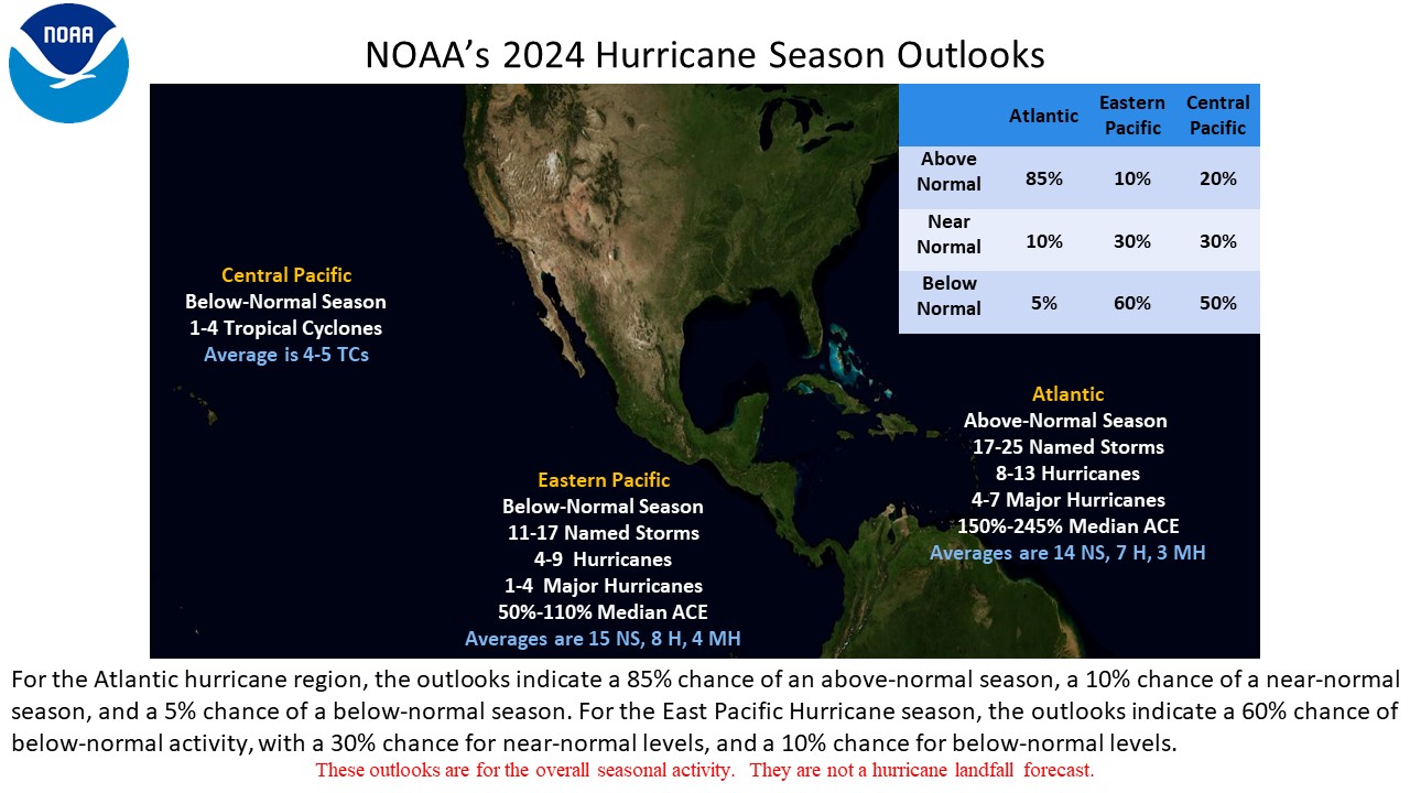
In other words, busy.
There are a number of factors involved in this: We are transitioning into a La Niña event in the Pacific, we are in a background state of above normal tropical activity that likely began in 1995, and sea surface temperatures in much of the tropical Atlantic are at record levels and are running near late August averages. That isn’t a typo. Dr. Kim Wood at the University of Arizona and Michael Lowry in South Florida have been two of many prominent voices sounding the alarm on this for months now.
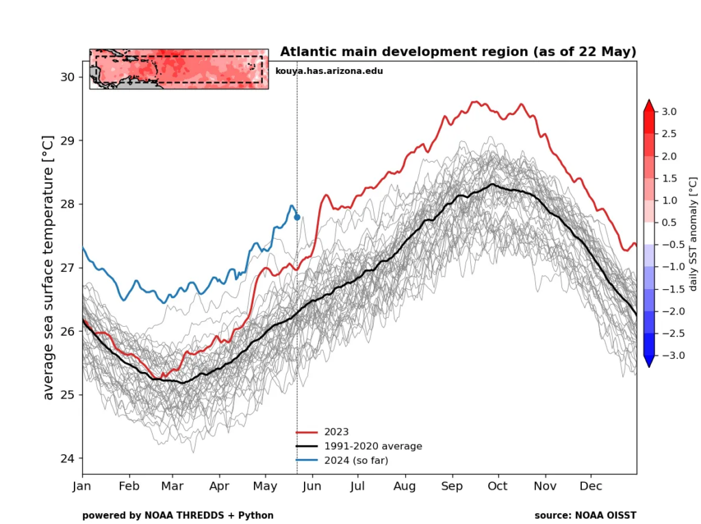
Wood has sea-surface temperature maps for various sub-basins of the Atlantic, and while the Gulf of Mexico is only running about 2 to 3 weeks ahead of schedule, the basin overall is running near August levels. The Caribbean? That’s even worse, running *above* peak average sea-surface temperatures for the entire year. Already.
We can hope for a 2010-like outcome, where it was a busy season but most storms avoided land (with a couple notably tragic exceptions). But given these sorts of antecedent conditions coming into the season, this would be a favorable outcome.
The NOAA outlook, combined with virtually every other hurricane season outlook is saying this year will be busy. It may or may not be busy for you, but we are getting to the point where there aren’t a whole lot of ways to describe any of this that in non-hyperbole. The bottom line is that this is the year to be prepared if you live anywhere on the coast. Just in case.
Watching the Caribbean, sort of
And with that, we have a disturbance to keep tabs on in the Caribbean already.
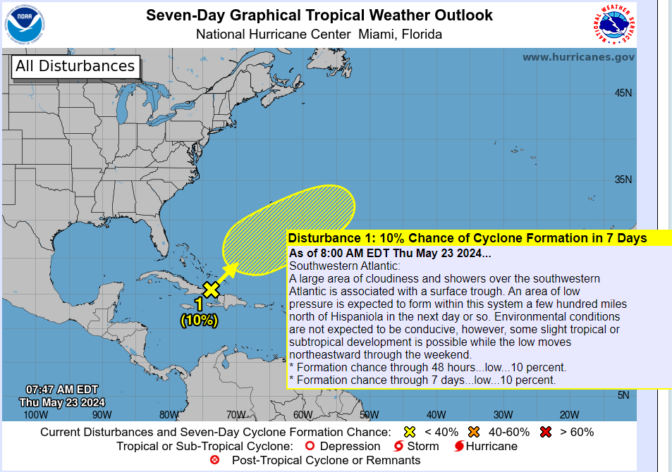
Looking at satellite, there’s not a whole heck of a lot to this one. There’s definitely a “center” of the disturbance near the eastern tip of Cuba, but it’s on the way east and northeast. So it will be out in the open water before too long.
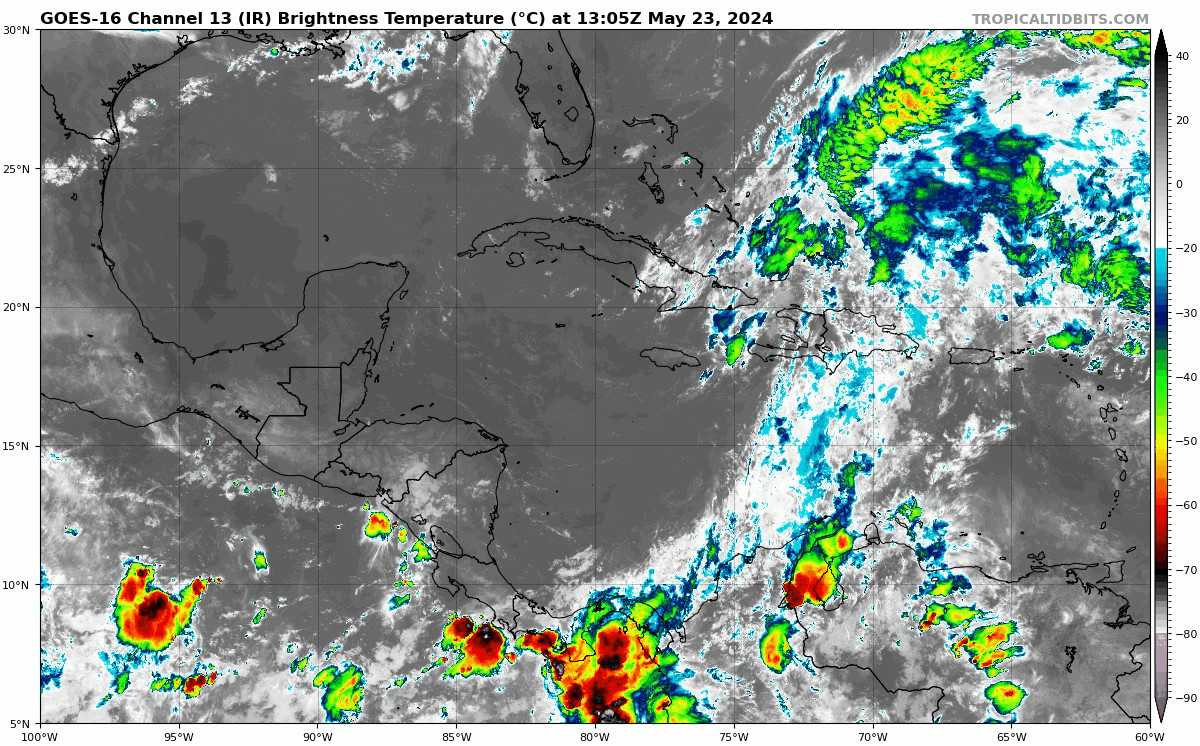
Ten percent seems like reasonable odds for development at this point, but no impacts of note are expected even if it does form.
Otherwise, things look quiet for another week or so. We may have another disturbance to watch in the Caribbean in about 10 days or so. We’ll keep you posted on that.
Thanks Matt for summarizing NOAA outlook! I saw a similar article on NPR that showed an image credited to NOAA that had a sea temperature map and then a box around a specific area titled “Main Hurricane Development Area”. It seems to be in the zone right where we would expect hurricanes to form and move into the gulf if the conditions were right. Any thoughts or analysis on that image? I’ve tried to include a link to that article to this comment….
https://www.npr.org/2024/05/23/1251003581/2024-atlantic-hurricane-season-noaa-forecast?utm_term=nprnews&utm_medium=social&utm_campaign=npr&utm_source=facebook.com
Absolutely. So the Main Development Region (MDR) is the primary area in the Atlantic where some of the bigger storms we watch for days form. Some people define the MDR differently and include the Caribbean or stop it just east of the islands. I think for the Gulf the reality is that a lot of storms do form in that broader region, but many actually form to the west of there, either in the western Caribbean or in the Gulf itself before lifting north. So it’s more complicated here. But for Florida, the East Coast, Central America, and the Caribbean, obviously you watch the MDR closely.
I’ll take the quiet while we have it 🌻
Every outlet is hyping (except you guys of course) an active to overactive season given sea surface temps, etc., but what I don’t see discussed are the steering currents and how they will be the same or different this year. Aren’t stronger storms that swirl across the Atlantic more likely to recurve out to sea and never affect land? It is hard to be wrong if you are JB and paint the entire Caribbean, Gulf of Mexico and Eastern Seaboard red as a potential strike point.
That’s why we don’t try to play the landfall prediction game. It’s too hard and too many external factors and short-term factors that cannot be seen right now are at play. At a high level, I personally think this year will resemble more last year than, say, a 2020 in terms of tracks. But at the same time, I wouldn’t be willing to stake my reputation on it either ha. Guys like JB will always overhype…that’s his brand. We’re more focused on the things we can tell you. And all we know right now is that the factors at play for the upcoming hurricane season support a very active one.
I’m not Matt or Eric, but if I may chime in…..the hype is not being done solely based off of SST’s. There are numerous factors that go into favoring (or inhibiting) cyclogenesis. All of them point to an overly active season. Regarding steering currents….we tend to see more Gulf/Bay of Campeche landfalls historically in weak La Nina phases (which we are currently in and forecasted to be in through the thick of the season). El Nino, neutral, and strong La Nina conditions tend to see more storms curve out to sea.
Bottom line is there is almost zero chance of a below-active season and the historical trends favor more storms in the Gulf/W Caribbean, which obviously does give pause to all of us along the Gulf Coast.
If you have the ability to do so, you should give a look to ABC 13’s Travis Herzog on Facebook and his post this morning regarding steering during different phases, specifically as they pertain to Texas.
This is the main reason I’m getting well away from the Gulf Coast when I retire. Already had to evacuate twice, don’t want to try again when I’m 75 or 80. With this type of season becoming more and more the norm, it makes the already stressful summers all the more stressful. It wasn’t like this in the 90s.
Can you comment on NOAA’s track record for its forecasts for the past several years, i.e., forecast vs. actual, or point me to a good resource on that? Thanks.
Their forecast archive can be found here: https://www.cpc.ncep.noaa.gov/products/outlooks/hurricane-archive.shtml
Just looking at the last 5 years of named storms/hurricanes/majors (and taking the midpoint of their range)…
2023: Forecast 14/7/3 and verified with 20/7/3
2022: Forecast 18/8/5 and verified with 14/8/2
2021: Forecast 17/8/4 and verified with 21/7/4
2020: Forecast 16/8/5 and verified 30/14/7
2019: Forecast 12/6/3 and verified 18/6/3
In most cases they seem to underforecast named storms and do a pretty decent job on hurricanes and majors (2020 excepted). But overall, I’d say they do a really good job.
Curious to know your thoughts on the higher probabilities of our area getting hit during an ENSO-neutral period and how long we might be in that situation this summer? https://www.facebook.com/share/p/qZh6bumMHqTQiJEw/?mibextid=WC7FNe
The data is the data, but the reality is that every hurricane season is different and every transition from El Nino to La Nina is different. Every meteorologist views things differently, but I’m perceiving this hurricane season to be more La Nina than ENSO neutral. At the same time, I would use caution with the fact that fewer storms have hit in La Nina than ENSO neutral. I also think that the sample size is a little too small to make any real telling claims in terms of specific landfall points. We can say things more confidently about the flavor of hurricane season more than we can about specific landfalls. And also keep in mind that Texas is big! So there’s a lot there. I agree with the idea that this is a good year to take preparation more seriously than usual and develop good habits, but in terms of landfall odds, I’m hesitant to walk that path too far.
Why NHC is so good at forecasting hurricane tracks, but seems to underestimate the intensity? RE seems now the norm in the Gulf. Are the models inadequate?
It’s a good question. We’ve made great strides in track forecasting and baby strides in intensity forecasting. A lot of the internal processes that help drive intensity have been tough to model or figure out. I think there is some new tech this year that will hopefully help with that, so I expect we will see some more impactful improvement. I think we’re close to catching up with track forecasts but we need a few more years.