It appears that we pretty clearly have our next item to watch on the docket out in the Atlantic, so most of today’s post will be devoted to that. Let’s jump right in.
One-sentence summary
Development is becoming increasingly more possible in the eastern Atlantic, an extremely rare occurrence this early in the season.
Happening now: Slow Atlantic development possible
The National Hurricane Center has bumped up the chances of development with the tropical wave off Africa to 50 percent over the next week as it marches west across the Atlantic. This remains exceptionally far east for this early in the season.

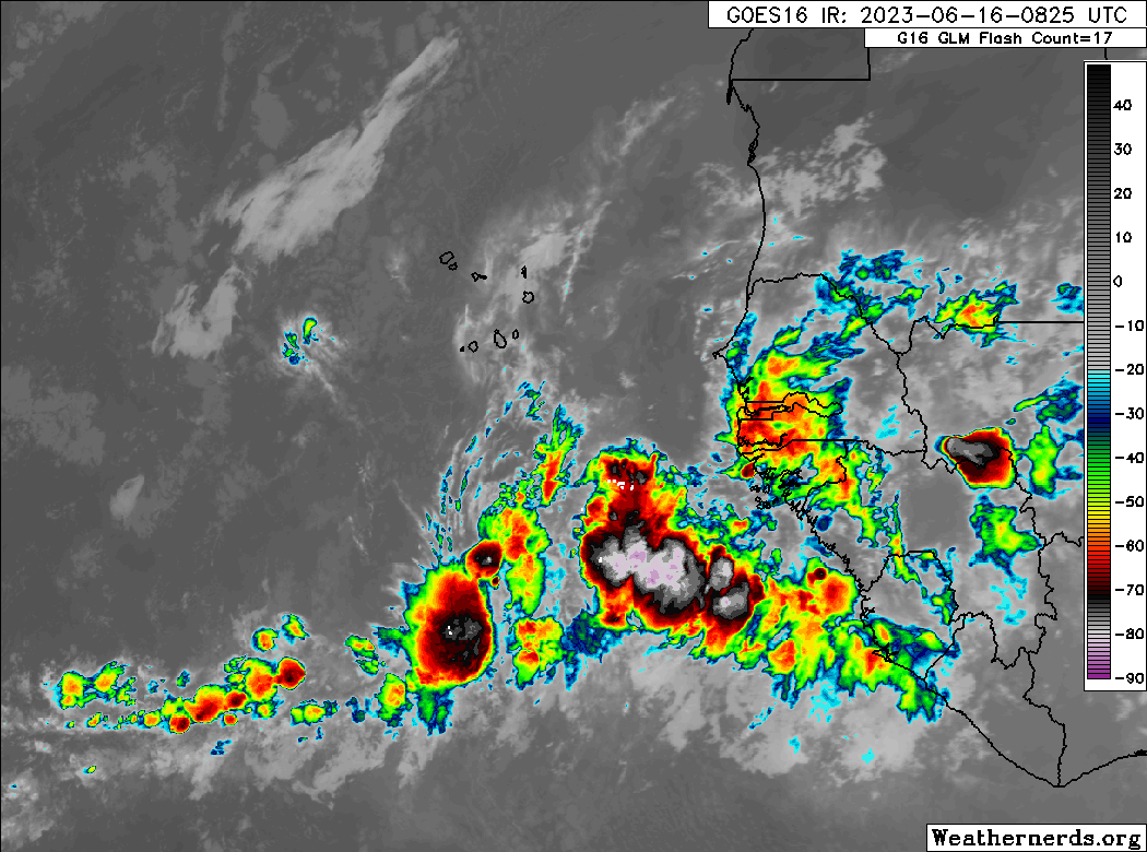
If we take a look at a satellite loop off Africa (which feels really weird to type in mid-June), we see a truly robust looking wave moving west. This looks much more like August than June, likely speaking to the exceptionally, record warm water temperatures in the eastern Atlantic.
The system remains an open wave at this point, but it will likely be declared an “invest” sometime this weekend or by early next week. Any development over the next 3 days would be slow. By days 4 and 5 (bringing us to Monday and Tuesday), we could see some consolidation in the open Atlantic east of the Caribbean islands.
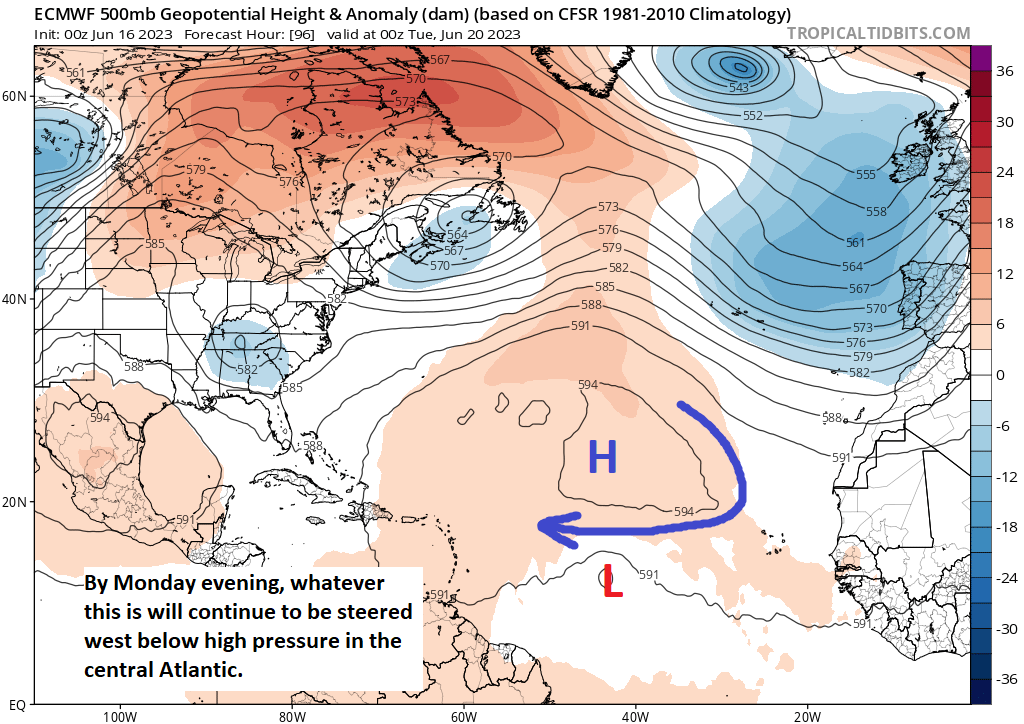
The system will be steered basically due west around the base of high pressure in the central Atlantic. Development will likely be sluggish as it fends off some shear and dry air in the neighborhood. But it seems plausible that a slow, steady attempt at development will occur through Tuesday. Which takes us to…
The medium range (days 6-10): Watching how well-organized the Atlantic system can get
As this disturbance makes its way toward the islands, again, we expect development to be sluggish but generally in the direction toward organization. Here’s where it gets tricky. Any future track of this disturbance will probably be contingent on how strong it gets. In other words, the stronger the system is, the more likely it is to begin gaining latitude. The weaker and more disorganized it is, the farther south it will track.
We can see this nicely illustrated when looking at how the European ensemble is handling things. By day 8, next Friday, there are two pretty clear camps showing up. Remember, we use ensembles to get a realistic spread of outcomes by tweaking a model a bunch of different ways and re-running it 30 to 50 times. In the Euro ensemble, we run it 51 times. We aren’t looking for the answer key, but we are looking for information we can use to inform our forecast analysis. In this case, we have what we need.
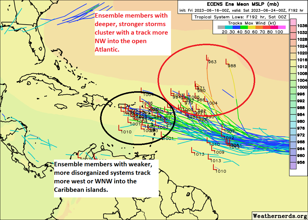
In this situation, ensemble members that blow up the system (tracks in yellow or orange) take it more north and northwest into the open Atlantic. Ensemble members that keep the system on the weaker side (blue or green tracks) take it west into the Caribbean and toward the islands. And you can see that weaker outcomes outnumber stronger outcomes by a modest but notable margin.
So, we know that as this develops, we need to be watching intensity, as a stronger system will turn northwest faster. A weaker one will proceed toward the islands, putting them at risk for some impacts, hopefully not too significant. In that instance, the storm would probably gradually weaken beyond the islands as it encounters a more hostile wind shear environment closer to the US.
For now, if you are in the Caribbean, continue to monitor the situation. You have plenty of time to watch and hopefully it never becomes a big deal. We’ll keep you posted throughout.
Fantasyland (beyond day 10):
The good news is that aside from this system in the Atlantic, there is not much else to discuss. Yes, the GFS keeps springing noise on us in the Caribbean. No, we still don’t think it will amount to anything. For now, the only other action should be in the Pacific.
As of now, we’ll plan to check back in on Monday, but if the Atlantic disturbance does begin to organize more effectively than expected, we’ll join you Sunday for an update.
Hello all, I am going to be Orlando 6/26-6/30. I know you do not have a crystal ball that said though, any insight to what I may see around that time?
Can’t speak to any specifics this far out, but probably nothing tropical in nature!
Thank you!!
Those ocean temperatures are really something.
Since there has been very little hurricane activity (comparatively) in the last two seasons, there’s been little heat release in the Gulf. If El Niño continues this trend, how hot are those waters going to get?
A cooking Gulf is not good.
I don’t know that a lack of activity means much in terms of ultimate Gulf water temps now. A bunch of rain over the Gulf or several cloudy days would help ease temps back some. But there’s no doubt that there’s a lot of rich, warm water deep down that can be tapped in the event of a tropical storm or hurricane, so yes it is definitely a concern. Hopefully the anticipated wind shear will be around to bail us out!
☺️ ty