The storm in the Northeast and Mid-Atlantic yesterday absolutely blasted parts of the interior with heavy snowfall; a very impressive late March storm. There’s more winter coming, as it seems we’re making up for a winter of little winter now in spring. A tip of the cap to the groundhog who missed this one. Today’s post also explains how we’ll be looking at the forecast as it relates to the solar eclipse on April 8th. (Post updated with new details on severe weather chances today and tomorrow)
Headlines
- Northeast snow was impressive; we recap totals.
- Next storm will dump snow in the Plains, Upper Midwest, and Ontario.
- Fire weather danger and powerful winds in the Southern Plains from this storm.
- Severe weather possible as well.
- Another storm next weekend?
- The way too early eclipse preview and what we’ll be seriously watching over the next few days with respect to that forecast.
Digging out in New England
Landgrove, Vermont checks in this morning as the champion of yesterday’s massive interior snowstorm. They received 32 inches of snow there, with other parts of Vermont, New Hampshire, and Maine seeing amounts that were also impressive: The White Mountains south of Conway, NH seeing 28 inches, 27.3 inches near Ludlow, VT, White River Junction in the Connecticut River valley seeing north of 26 inches, and Bryant Pond, ME seeing 25 inches.
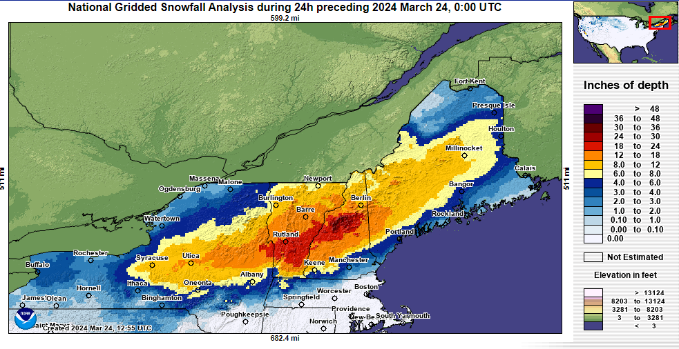
The totals were impressive in valley locations to be sure. Typically in March, there’s a strong elevation bias in snowstorms in New England or the Adirondacks. That really was not the case yesterday. This was just a dump of moisture, as rain totals south of the snow were also impressive. Places like Philadelphia saw their wettest March day and wettest 24 hour period in March on record, dating back to the late 1800s. So for those of you that like snow, congratulations!
What’s coming next?
The next winter storm will dump a substantial amount of snow today and tomorrow in the northern Plains and Upper Midwest.
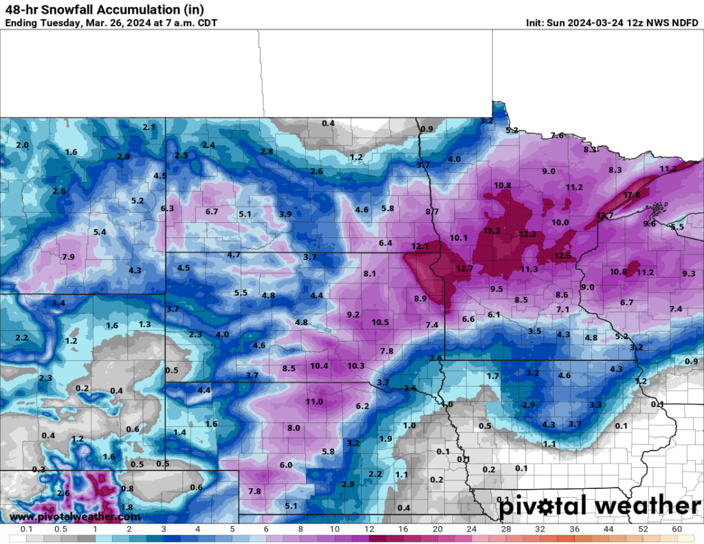
Snow totals of 25 to 45 cm will occur in Ontario, including Thunder Bay as well.
This will be a significant storm for the region, with blizzard warnings posted south of here from southern South Dakota into interior Nebraska and extreme northwest Kansas; also just south of Denver too. Wind gusts of 60 mph or stronger are possible in those areas, which when combined with snow will probably produce blizzard conditions. Remember, the amount of snow that falls is not a condition required to meet the definition of a blizzard. It has to do with visibility and wind: At least 3 consecutive hours of falling snow, low visibility below a quarter-mile and sustained winds or frequent gusts over 35 mph.
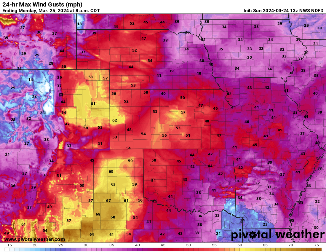
Working our way south, these type of wind gusts will contribute to critical fire weather danger today in the Texas Panhandle and Permian Basin south to Big Bend.
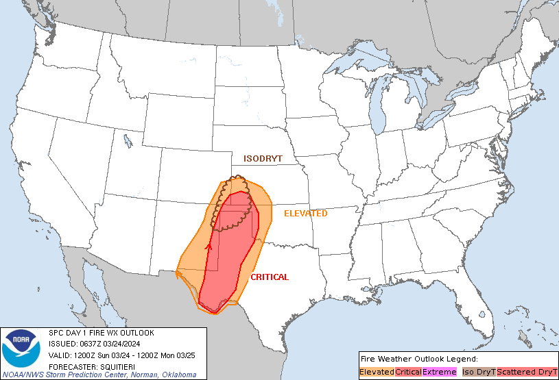
Red flag warnings and high wind warnings are posted all over this area, with wind gusts of 55 to 65 mph and relative humidity at 15 percent or less.
Not to be outdone, severe weather is a possibility from portions of Kansas and Oklahoma into Texas today, shifting east into the Lower Mississippi Valley tomorrow.
(Update: 1:30 PM CT Sunday): The NWS has increased severe weather risk for the rest of today, as well as tomorrow for portions of the Plains and Lower Mississippi Valley.
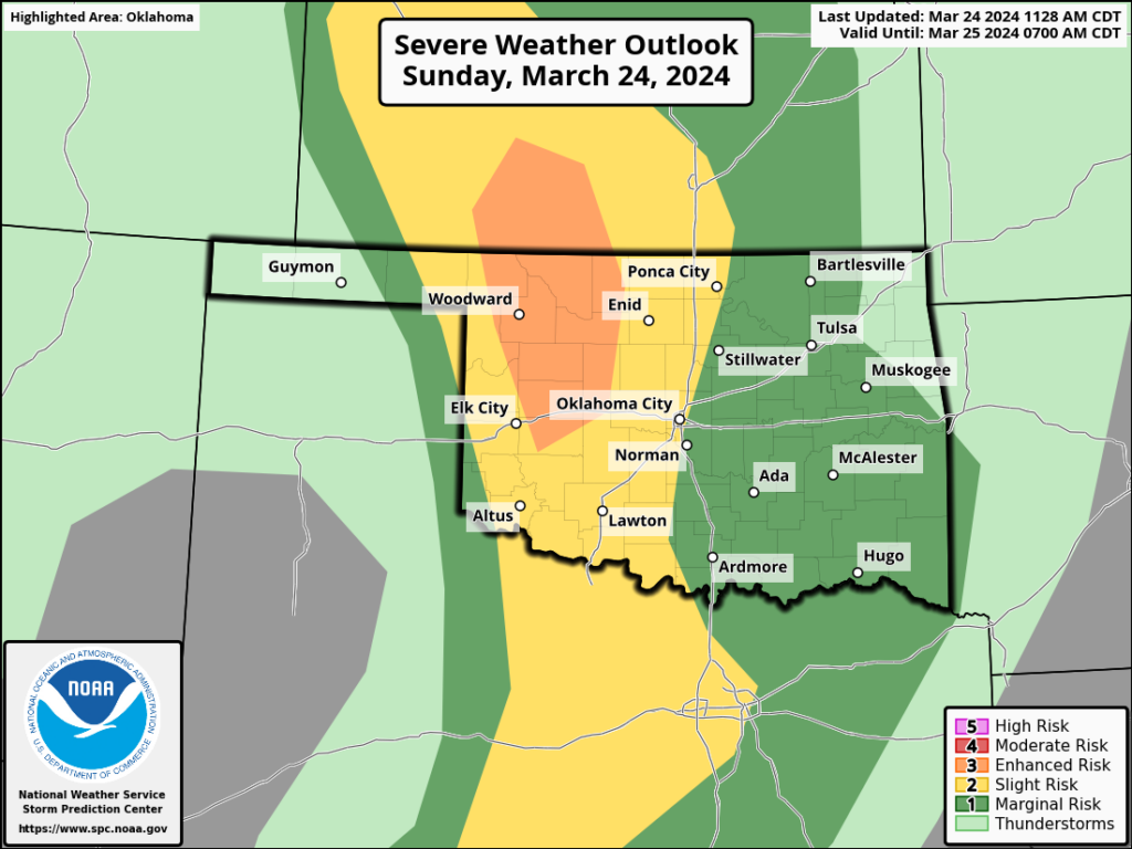
An enhanced risk was added to southern Kansas and northwest Oklahoma for today. It seems that ingredients for severe weather are coming together a bit more vigorously in this region than expected. In addition to the risk of damaging winds and isolated tornadoes, there will be a good risk for big hail today in parts of the enhanced risk and adjacent areas.
Meanwhile, the severe risk was also upgraded to an enhanced risk tomorrow (level 3/5) for potentially strong tornadoes in portions of Louisiana and Mississippi.
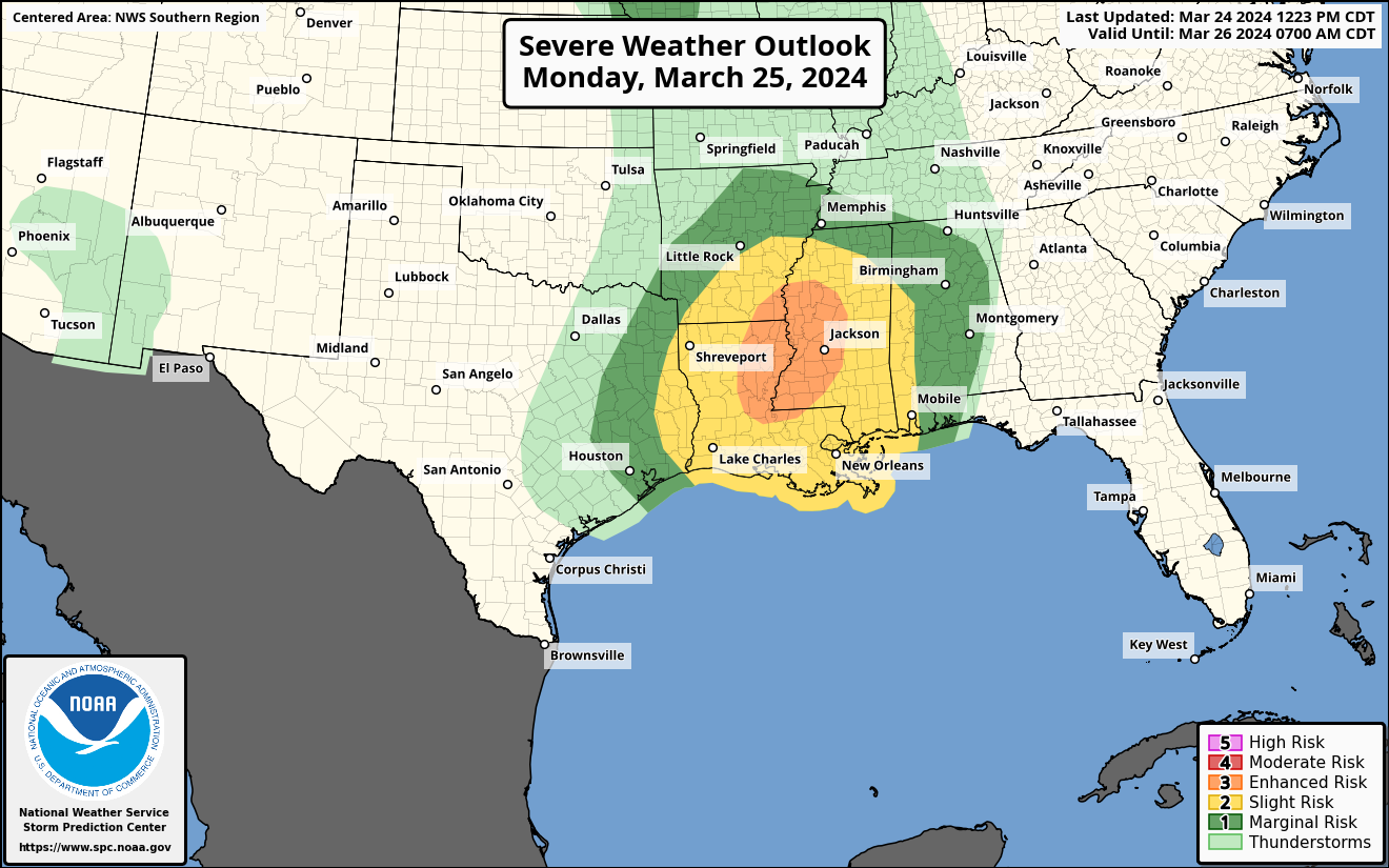
Tonight’s storms will weaken, but as the system moves east, look for storms to reintensify tomorrow along the Sabine River at the Texas/Louisiana border, likely peaking north and east of about Alexandria, LA, with a chance for both individual supercells and more of a messy squall line. Both types of storms will be capable of producing tornadoes, in addition to strong winds and perhaps some hail.
There will also be a lower-end severe hail or wind risk in parts of Iowa tomorrow as well.
Is that it? Are we done?
Perhaps not. There’s another storm aiming for the 30th and 31st, next weekend. Details are extremely fuzzy on this right now, but it’s being highlighted by the Climate Prediction Center as having a potential to produce heavy snow next weekend.
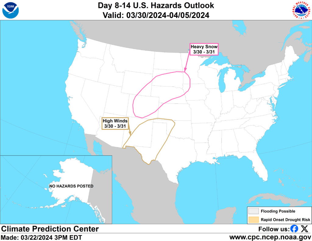
Looking at model guidance, there’s definitely a storm signal on all the relevant operational model guidance, though none seem too crazy right now. Still, when looking at ensemble guidance to get a sense of the spread within the model guidance, there’s a healthy amount of uncertainty in terms of track and intensity. So we’ll watch this through the week.
A wayyyyy too early eclipse preview
Good news and bad news today: The good news is that our model guidance reaches out to Eclipse Day on April 8th!
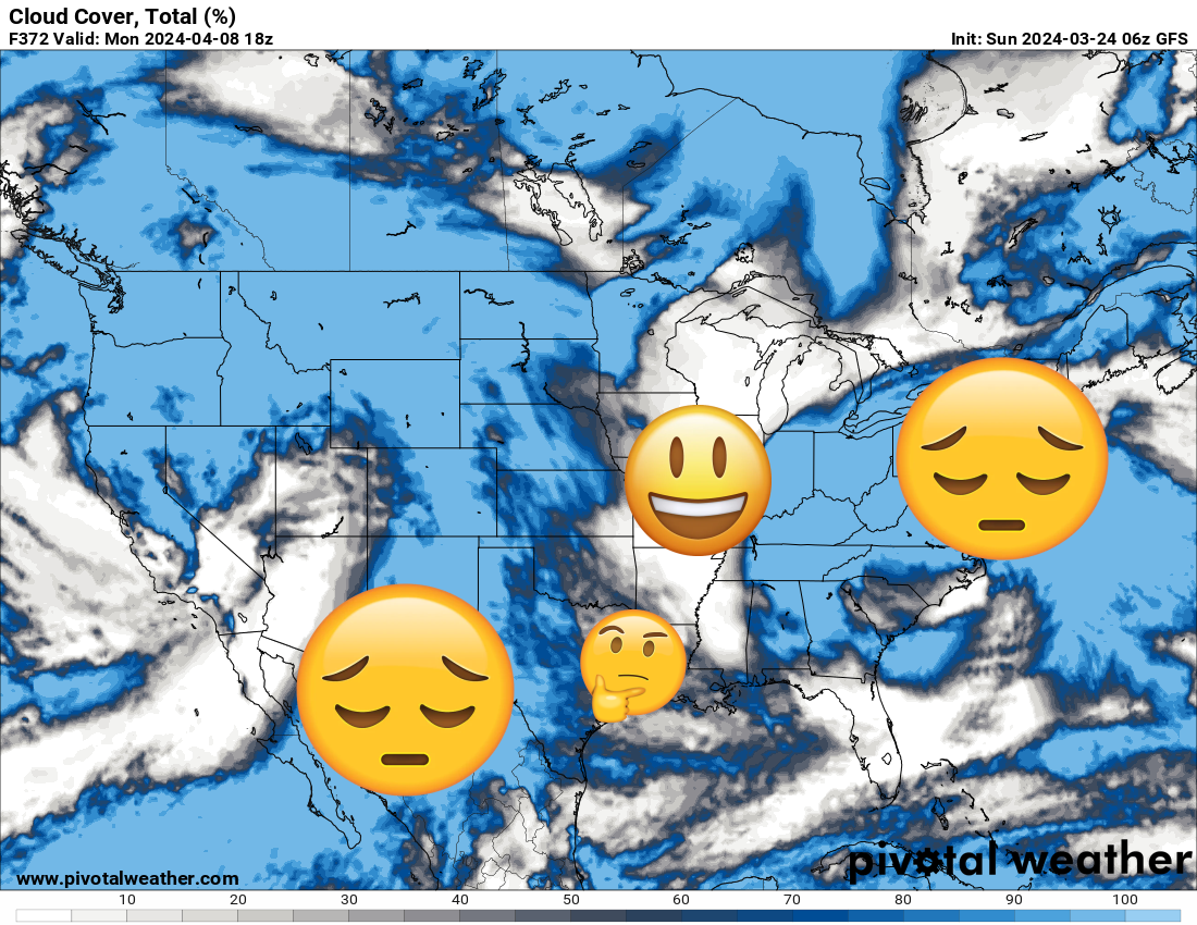
The bad news is that it’s really just the GFS operational model, and it tells us nothing of planning value with respect to the eclipse. What we’ll be watching for this week will come primarily from ensemble model guidance. What I want to know this week is what the odds are of a storm system somewhere along the path of totality. That will give me some confidence in terms of how I feel about cloud risks. While clouds are such small scale features that they’re virtually impossible to forecast at a level that matters for eclipse viewing until we’re within hours or a couple days of the eclipse, we can at least start placing some odds on areas that could be troublesome and areas that may be less troublesome come Monday the 8th. We’ll be updating this a couple times this week and probably daily next week. Stick with us for the latest!
Is there a prediction for our Houston summer weather? Will it be another drought with two months of extreme heat like last summer?
Would like email