Today, we take a look at what’s happening with our two main storms over the next few days; one will bring severe weather to the South and snow to the North, while the other will bring heavy rain and heavy snow to parts of the Northeast and Canada.
Headlines
- Heavy rain tomorrow in South Florida.
- Heavy rain Saturday for the Mid-Atlantic and Northeast.
- Heavy snow again in the interior Northeast up into portions of eastern Canada this weekend.
- Heavy snow North and severe weather possible South Sunday-Monday.
An East Coast soaking
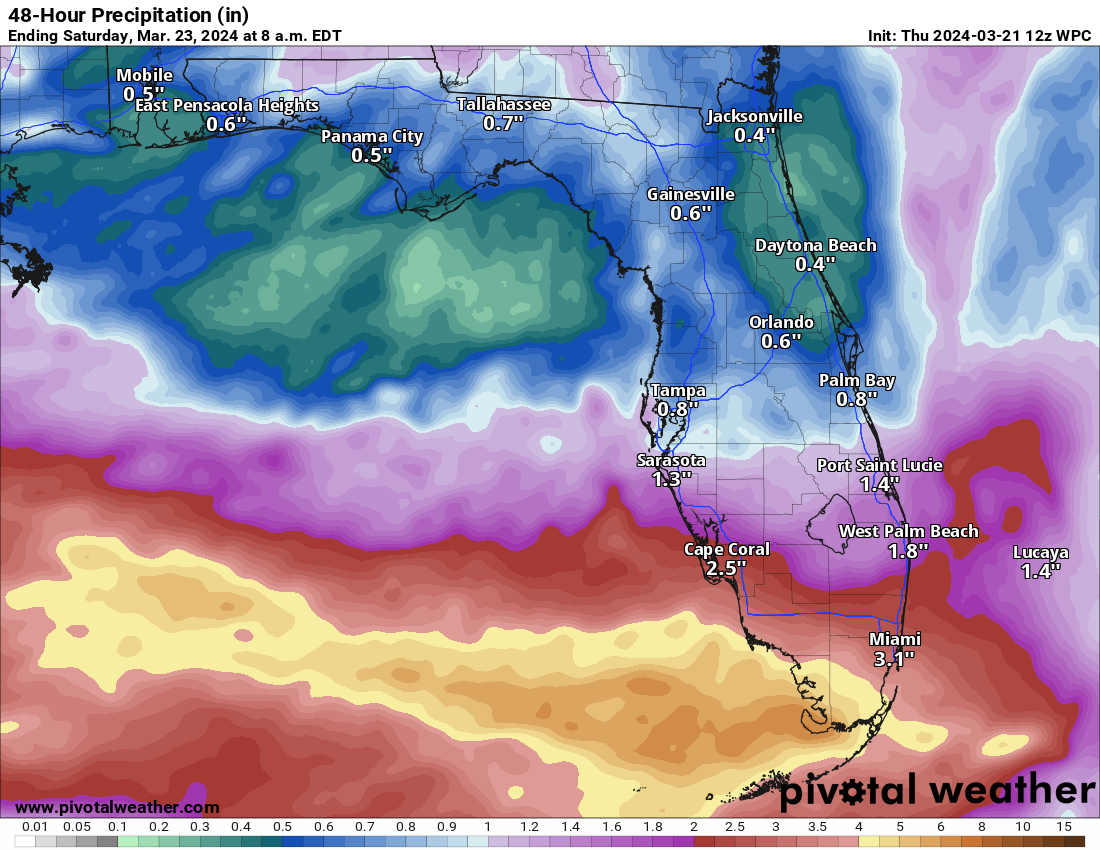
There will be two areas to watch in the Eastern U.S. this weekend. The first is in South Florida tomorrow, where heavy, soaking rain will likely fall south of Alligator Alley. For Metro Miami, this probably won’t be a huge ordeal, but there will likely be some areas of street flooding. Southwest of there is where the heaviest rain will occur. Fortunately, it’s a relatively sparsely populated area. Rain will move in toward morning and continue off and on, probably escalating in intensity through the afternoon or evening.
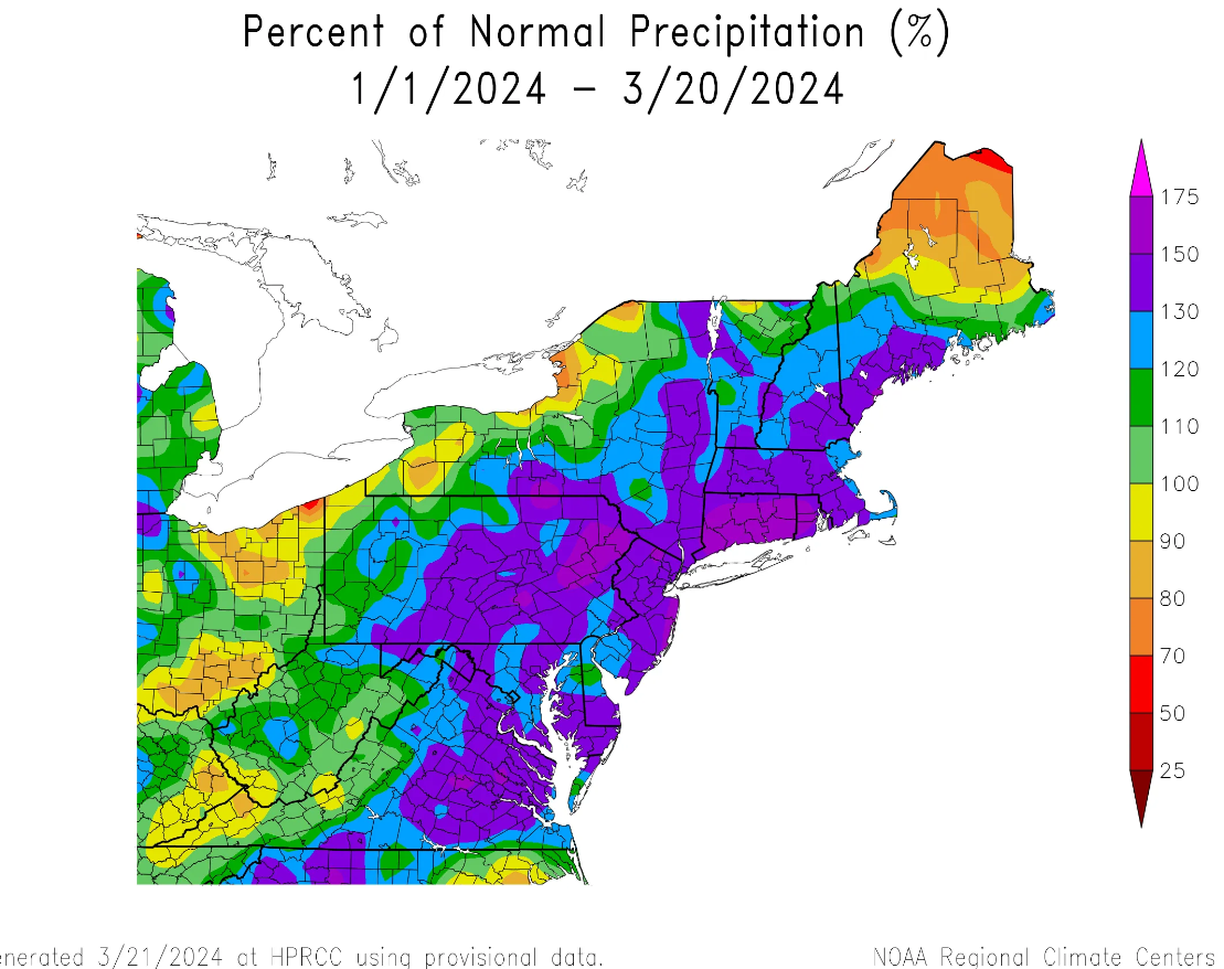
The second area to watch will be in the Mid-Atlantic and Northeast on Saturday where yet another round of rain is expected. For those of you scoring at home, the Northeast has had quite a bit of rain since last year. So far in 2024, the region is running around 120 to 175 percent of normal rainfall.
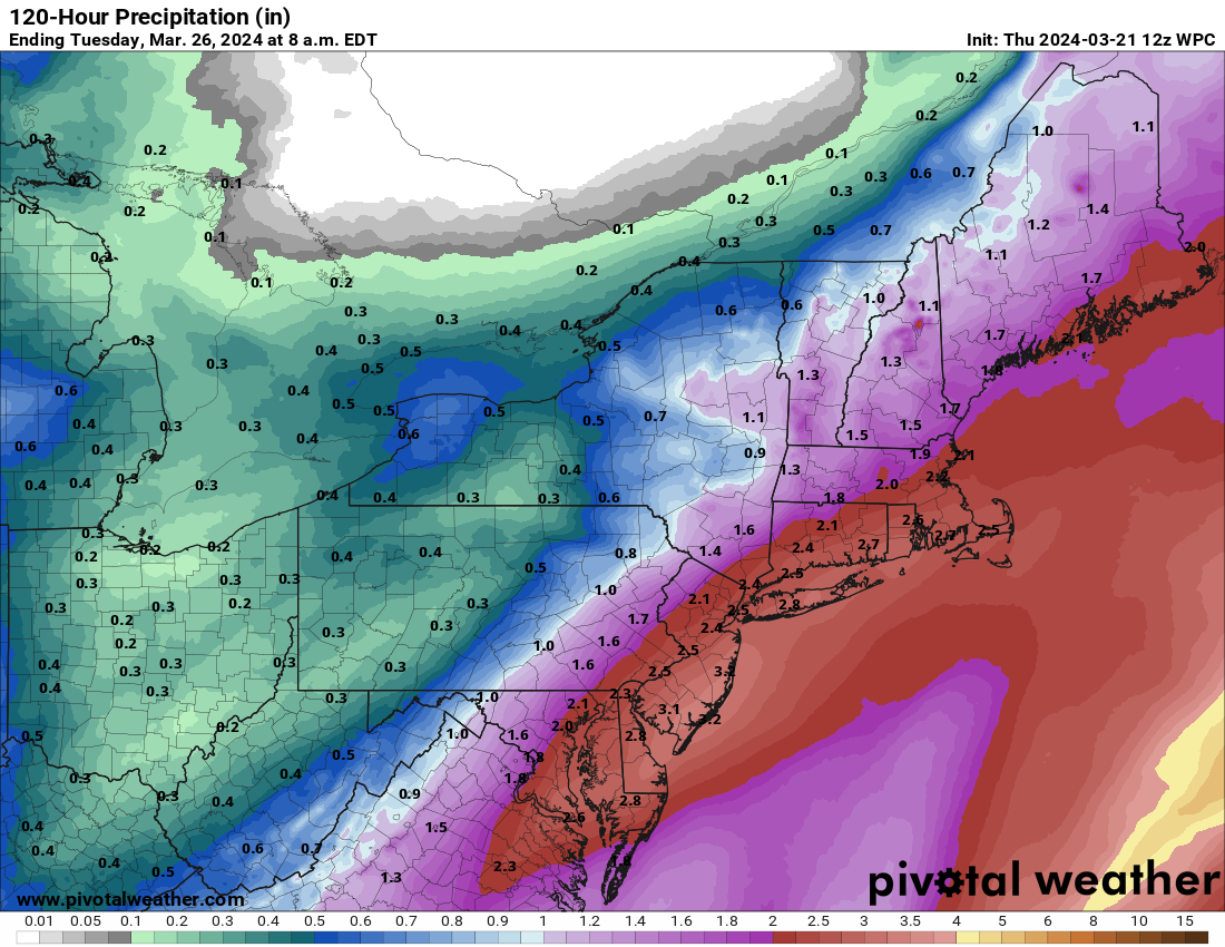
The ground is pretty saturated heading into spring, and this next round of rain will add anywhere from 1 to 3 inches more to the mix, likely leading to some street flooding in spots. Minor river flooding is also a possibility in a few locations.
There is potential for yet another system later next week in this region as well.
More snow in the Northeast, too!
In addition to the rainfall impacts of this system, heavy snow will be possible for portions of northwest New England and up into eastern Canada, particularly toward the Gaspe Peninsula in Quebec and perhaps northern New Brunswick. For most of Atlantic Canada, this will likely be a rain and gusty wind event.
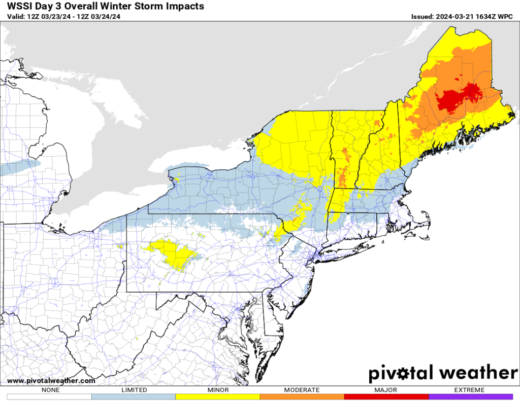
There are still some things to sort out, but winter’s not done yet here.
As we noted yesterday, winter ain’t over in the Central U.S. either! We continue to see high odds of plowable, significant snowfall for portions of Minnesota, particularly from the Twin Cities south and west.
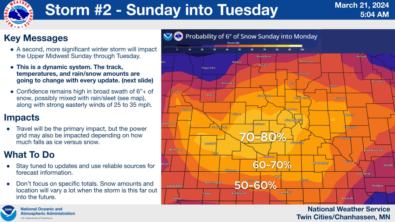
There remain high odds that the Dakotas will also cash in on this one with at least 6 to 12 inches of snow. A wintry mix would be possible on the southern fringe of all this, from Nebraska into southeast South Dakota and perhaps Iowa or southern Minnesota. An impressive, active late March weather pattern.
Severe weather chances Sunday-Monday
We got an update today from the Storm Prediction Center on next week’s severe weather risks in the South. Things are generally unchanged for Sunday in the Southern Plains with an axis of severe storms possible from Kansas through Texas. A new area was highlighted for Monday in the Deep South.
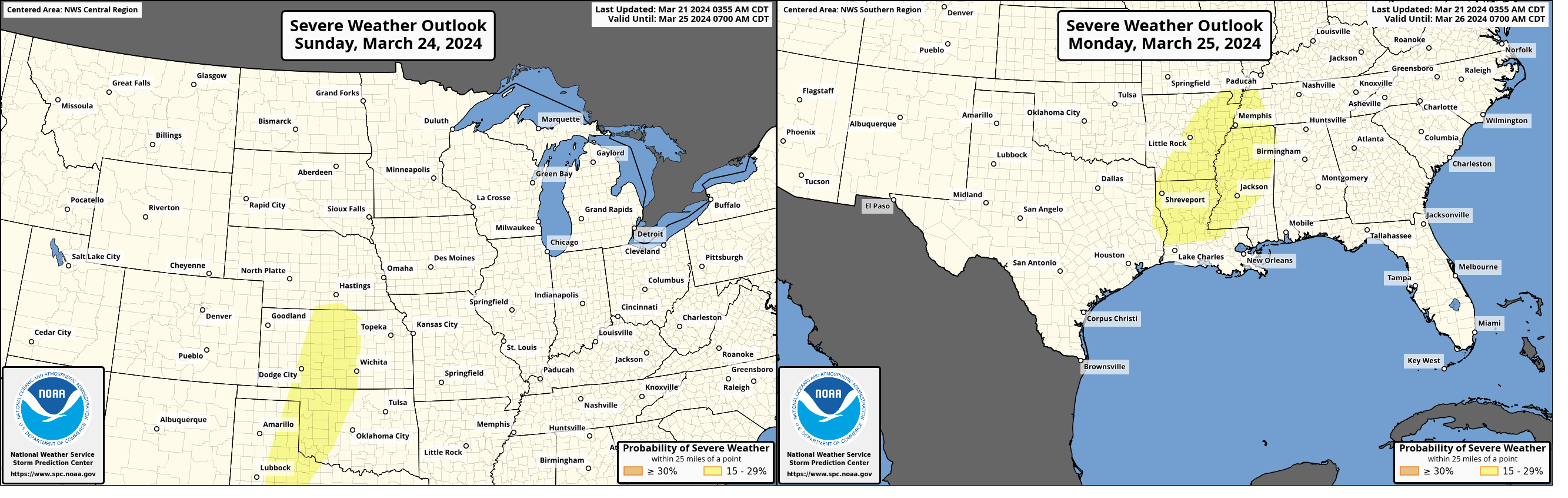
The first day of storms on Sunday will probably initially be some isolated strong to severe storms; where you’d typically see a couple tornadoes try to develop. But that should quickly transition into more of a “linear” type squall line and damaging wind/hail threat. On Monday, with some of the better Gulf moisture in place over the Lower Mississippi Valley, we could see a slightly better chance at severe storms, including supercells and/or a few tornadoes in that area. I think Monday has more risk than Sunday right now to be a more impactful day, but as always, we’ll see.
More severe weather chances may have a chance to emerge later next week, but nothing currently looks concrete in nature.