One-sentence summary
Tammy continues to provide some uncertainty, and Otis will come ashore near Acapulco as a hurricane tomorrow, while the U.S. sees its first big winter storm in the North that will help usher in a round of colder air.
Tropics: Tammy being tricky, while Otis approaches Acapulco tomorrow
Hurricane Tammy continues to plod along in the southwest Atlantic moving northeast just under 10 mph. It continues to take on a less than classic look for a hurricane, but it is still maintaining hurricane intensity.
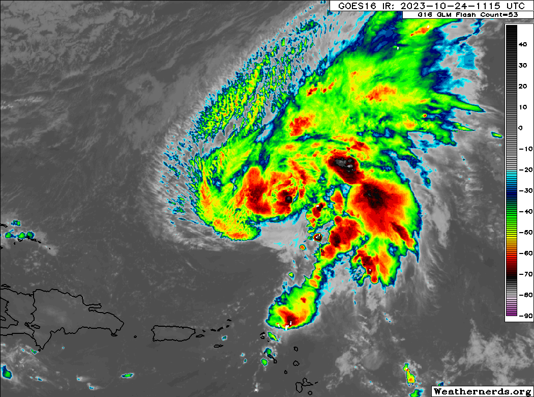
Tammy still has just a handful of showers trailing it into the islands, but otherwise, impacts from Tammy are limited to rough surf and rip currents at this time. The forecast track for Tammy continues to fan out all over the Atlantic, as various features that will dictate Tammy’s future track remain a bit uncertain.
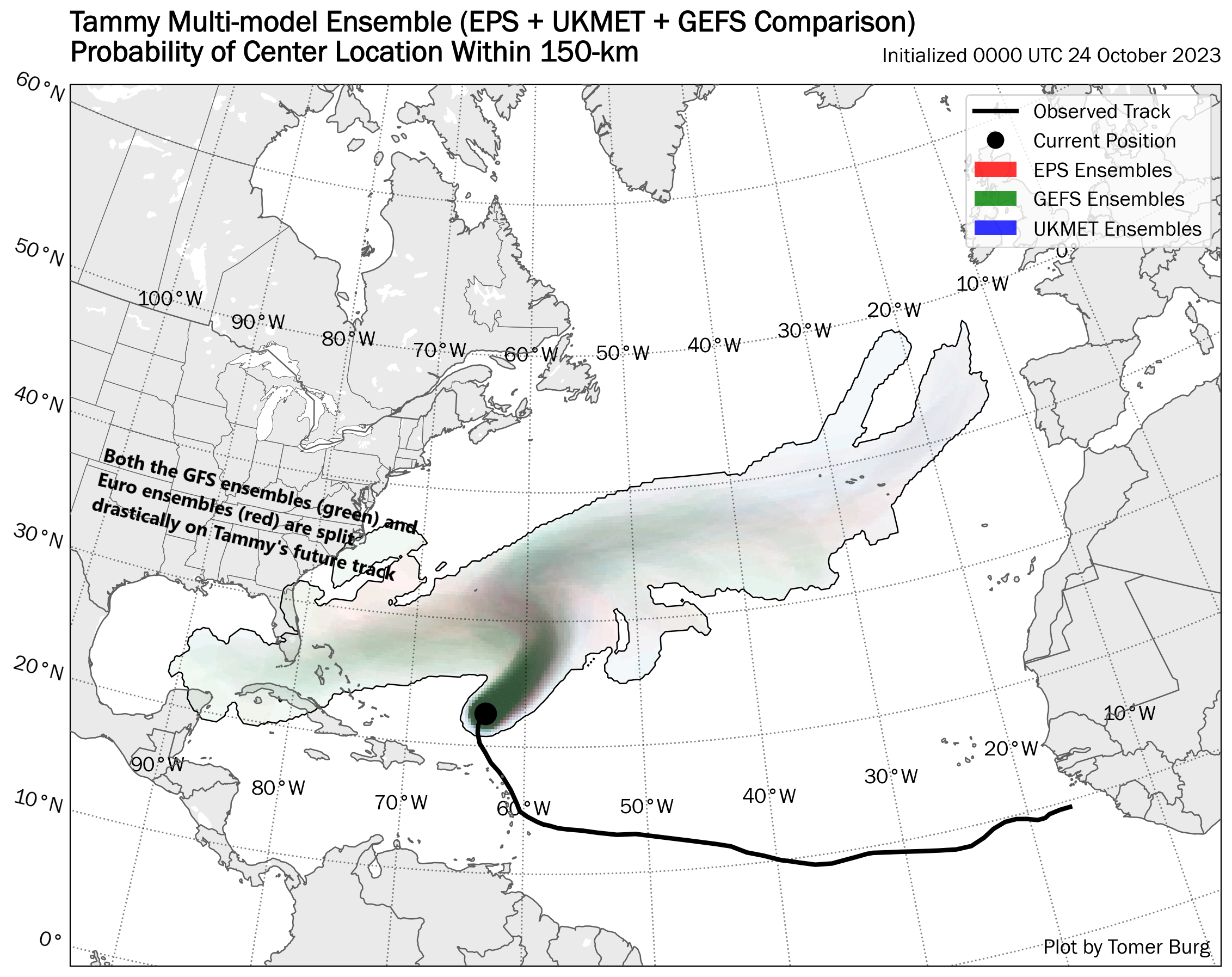
This is one of the sloppiest tropical system forecasts I’ve seen this year. The 180° spread in options is one of my least favorite ones to manage during hurricane season. Thankfully, the stakes are not as high in late October usually, and in this instance there is good agreement among the models that Tammy will slowly weaken such that most impacts to either Bermuda or the Bahamas and Florida would be modest at worst. We will keep an eye on things regardless, but at this time, Tammy is not an overly serious concern down the line.
Meanwhile, in the Eastern Pacific, Otis is likely to become a hurricane. Very few storms have not outpaced their forecast intensity this year it seems in the East Pac, and Otis will be another.
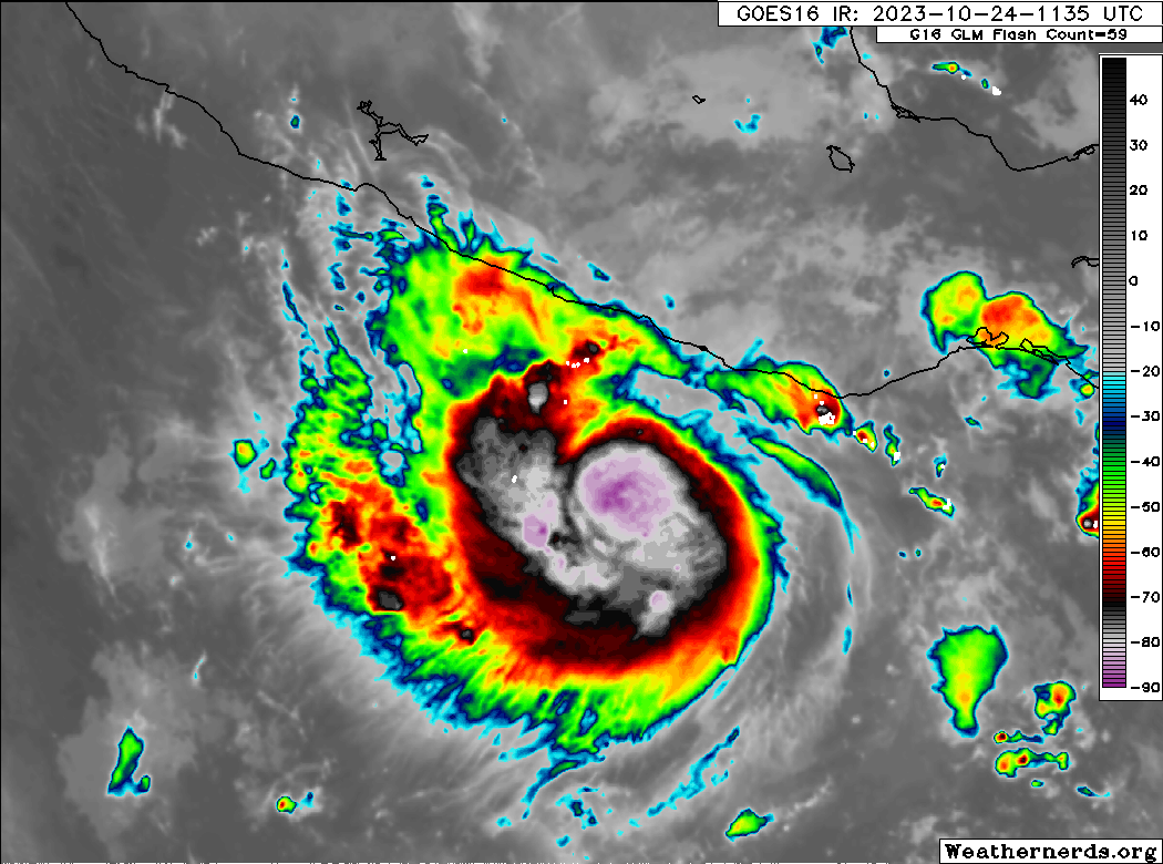
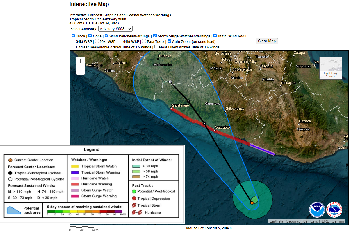
Otis should become a category one hurricane tonight or tomorrow before making landfall in the state of Guerrero in Mexico, probably just west of Acapulco. Hurricane warnings are up for the coast of Guerrero, with tropical storm warnings extending southeast into a portion of Oaxaca.
Beyond Otis, the Pacific should quiet down some.
Elsewhere in the tropics, things look fairly quiet. Tropical Depression 21 formed near Nicaragua yesterday and is ashore this morning, producing areas of heavy rain for Central America. There are no other serious things to watch at this time heading into the rest of the week.
U.S. Weather: Significant northern tier winter storm will usher in colder air that eventually spreads south and east
Winter Storm watches and warnings are posted from Washington across Montana and into North Dakota today as the first real big winter storm of the season gets going in the U.S.

Snow and cold temperatures will kick into gear across central and western Montana, with 8 to 12 inches of snow possible for places like Great Falls.
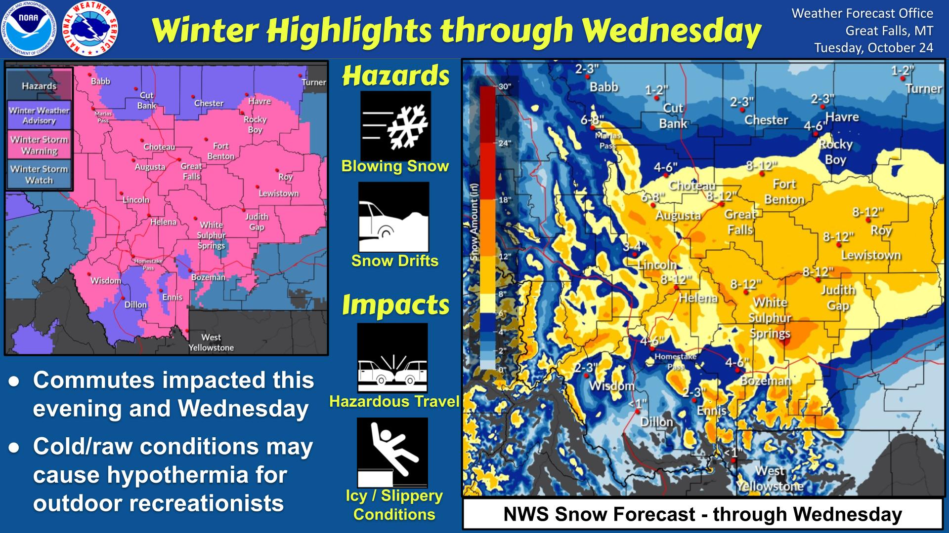
Over the next 3 days, snow will likely spread into North Dakota, and the current 50th percentile forecast for the next 72 hours will be 8 inches or higher there
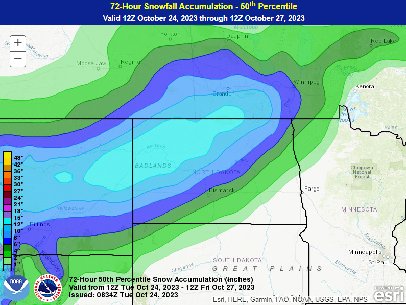
Snow should expand north into southern Manitoba and southeast Saskatchewan as well. Travel will be pretty rough across the northern tier over the next couple days. The first significant storm of the season always usually causes extra travel headaches too, so if you plan to be up north at all this week, take it easy.
It will turn quite chilly behind this storm over the next few days, with much below average temperatures across Montana and Alberta. Cool temperatures will expand into the Dakotas and much of the West Coast as well.

A handful of record lows are possible up that way. Meanwhile, downstream from the storm, extremely warm temperatures will dominate with numerous record warm low temperatures expected over the next few days.
Beyond this, a more potent south and east push of colder air is likely next week, erasing most of the warm weather for now in the Central and Eastern U.S.

Halloween should be a cooler one in much of the Central and Eastern U.S.
Does the western solution for Tammy mean anything to Houston?
Otis ain’t no Cat1, brother. NHC dropped the ball on this one.
Looking forward to the postmortem on Otis.
I think it’s harsh to say that the NHC ‘dropped the ball on this one’, but there will need to be a significant postmortem on the models.
If you look at the archived discussion thread, it’s a remarkable story:
– Oct 24 (4am) – maximum winds predicted 75KT, only 1 in 4 chance of Rapid Intensification
– By 10am estimate raised to 90KT, but ‘above average’ change of RI now showing
– The big change is 4pm – a Hurricane Hunter penetrates the core twice in one hour and there is a 10mb drop in pressure and that’s when everyone goes to red alert. NHC stresses the importance of aerial reconnaissance, and raises estimate to 140KT (Cat 4)
– They then issue a special advisory (7pm). Full alarm bells and the language shifts dramatically with first use of ‘catastrophic’ and ‘Cat 5’. This is just 7 hours before landfall.
– By 10pm (-3 hours before landfall) they are at 160KT and describe the situation as a “nightmare unfolding”. Also, makes the point that only Patricia (2015) has bettered a +95 KT increase in wind speed in 24 hours.
This is most definitely an outlier. And this part of Mexico has never really had to deal with anything like this in recent (living?) memory so it’s a really worrying scenario.