One-sentence summary
Philippe will bring a variety of weather to Maine, Quebec, and Ontario this weekend as it transitions to a non-tropical storm and offers up heavy rain, gusty winds, and even some snow in parts of Canada.
Philippe destined to follow Lee’s footprints
Tropical Storm Philippe is a little stronger today as the center approaches Bermuda. Wind gusts over 50 mph were reported on the island this morning. The forecast remains mostly on track, with Philippe essentially being a smaller, less intense version of last month’s Hurricane Lee.
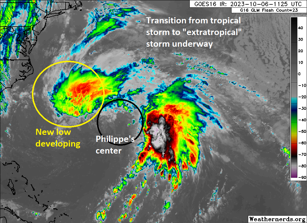
Philippe will likely become post-tropical by tomorrow and transition to a strong nor’easter-type storm as it moves toward the Gulf of Maine or Bay of Fundy this weekend. It is expected to hook back to the north and west across Quebec and eventually stall out on the south end of James Bay, bringing rain and even some snow to Quebec or portions of interior Ontario.
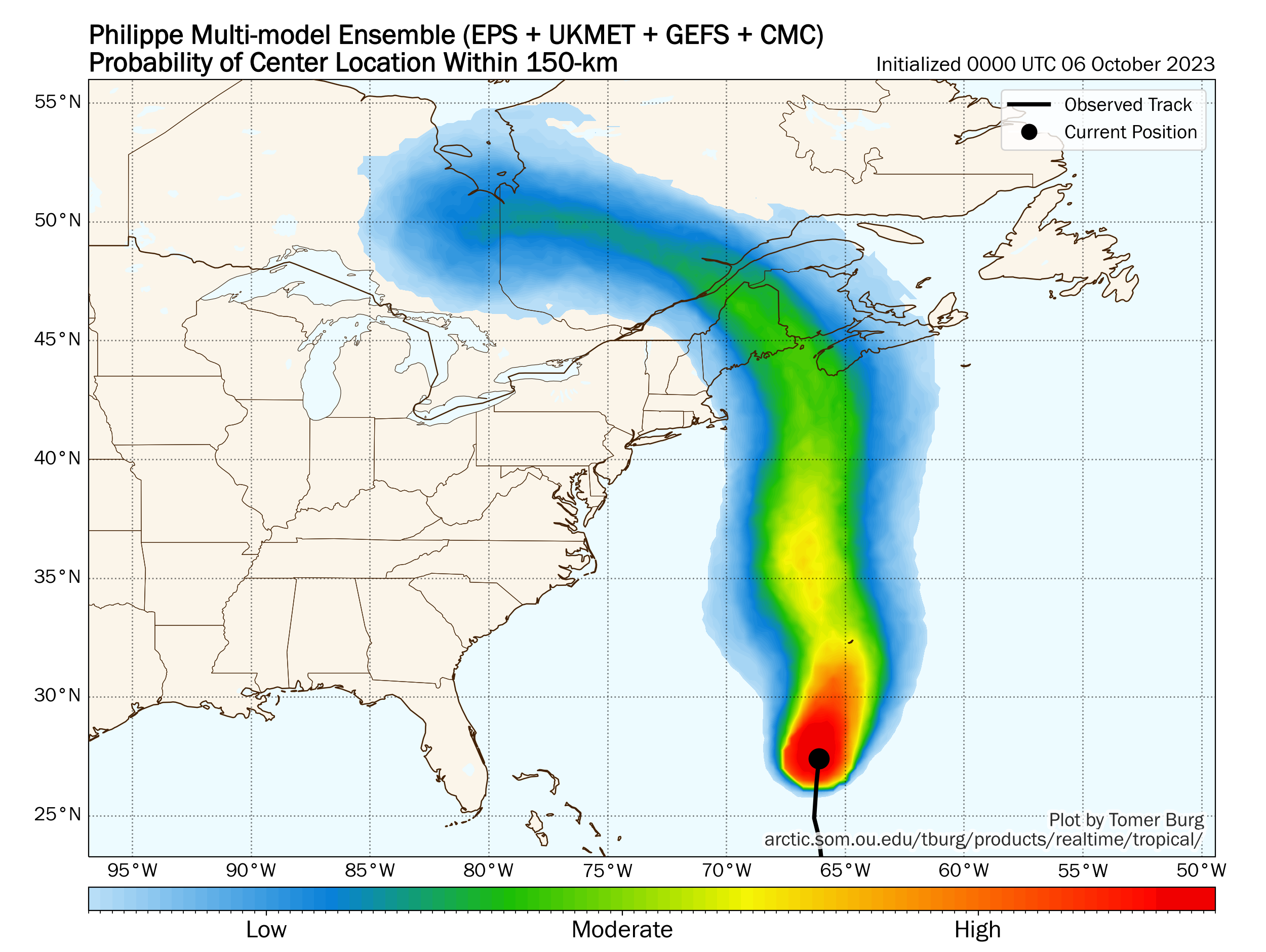
The National Hurricane Center will not be issuing tropical products for Philippe as it moves into Canada and New England, indicating that while it will bring impacts they should be managed at the local level. I think a very plain language translation of this means that, while a notable storm, it is not expected to be an especially damaging one. Marine impacts should primarily be gusty winds and large swells. We’re in a lower phase of the tide cycle right now so that helps mitigate that risk a bit.
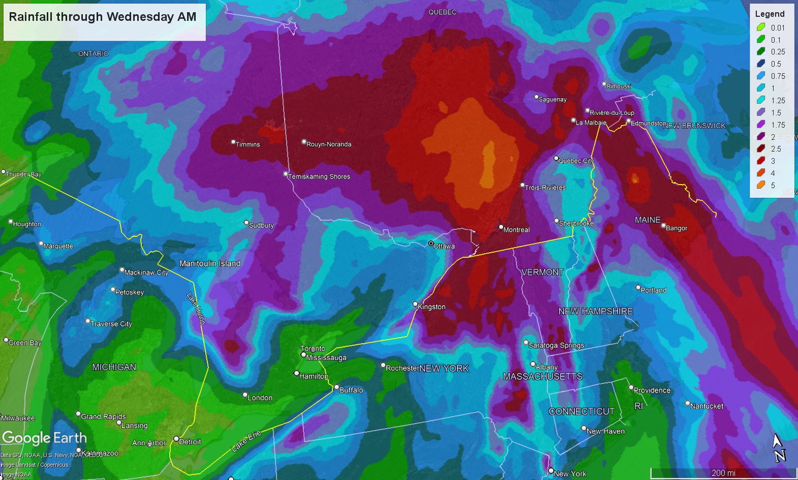
But the main concern with this will likely be tomorrow night and Sunday with locally heavy rain. Total rainfall may exceed 3 or 4 inches in spots, especially in interior Maine and Quebec (north & west of Quebec City, Montreal, and the National Capital Region). Grounds are still fairly damp, so flash flooding is a distinct possibility in spots. Snowfall would be most likely along the Ontario/Quebec border and north of a Sudbury-North Bay line in Ontario.
Watching the Gulf next week
We are starting to see some vague model agreement on next week’s setup with Pacific moisture and tropical noise tracking across Mexico and potentially into the Gulf of Mexico.
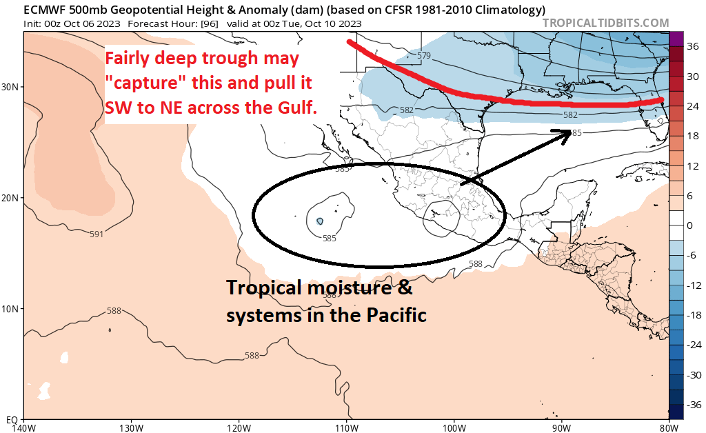
The pattern in the Pacific is such that we should see a bit of a weird entanglement between Tropical Storm Lidia, Invest 99E (the disturbance off the Mexican coast), and an upper level trough in the atmosphere over the Southern Plains and Southeast. How so? In some way, either Lidia or 99E or both will get “pulled” northeast toward Mexico by the upper trough, which will then allow that cluster to track into the Gulf of Mexico. From there, it should probably track northeast or east-northeast across the Gulf toward Florida or the eastern Gulf Coast. What will it be? I don’t know. Probably not a large storm; probably something lower-end. But it could end up being a rain and/or severe weather producer in the Gulf waters or near the coast (or ultimately in Florida). The timing of all this would be late next week. We have a few days to watch this, and we’ll have an update this weekend and on Monday.
Elsewhere, the NHC continues to outline an area deep in the Atlantic that could develop, but it is unlikely to impact land if it does so.
Winter is coming
In addition to the potential snow from Philippe’s remnants in Canada this weekend, we have freeze warnings now populating across the Plains. Freeze watches and warnings extend from northeast Colorado and central Kansas into the Dakotas and portions of western Minnesota.
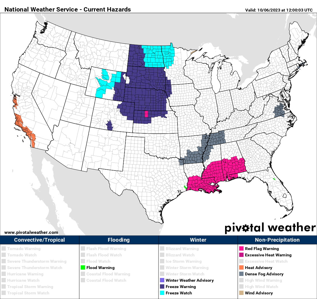
Low temperatures this morning are in the 20s in spots in Montana but will expand over a wider area on Saturday morning. A warming trend will follow for a time early next week.
Lower Mississippi River dryness
We continue to see the situation in the Lower Mississippi River basin look worse. For Louisiana salt water intrusion to halt or reverse, we need rain upstream; something that can basically flush the salt out. The forecast upriver from New Orleans does not look great, with Memphis likely to see a declining water level over the next 7 to 10 days and most of the Ohio Valley seeing less than half an inch of rain over the next week.
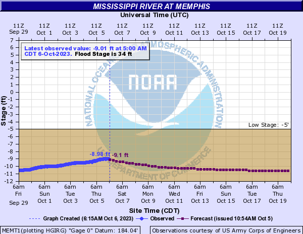
The water level at Memphis this year preliminarily set a new record of -11 feet, and the level by the end of the forecast above has them down to about -10.6 feet again. Hopefully some more meaningful rain can fall around mid-October in the middle Mississippi and Ohio River Valleys, but much more is needed to alleviate the expanding problems in Louisiana. Thankfully at least, the projections for how far north the saltwater wedge gets have slowed considerably.
Thanks for the tropical storm/nor’easter explanation in yesterday’s comments…you made it very clear!
Does next week’s tropical system in the southwestern Gulf create a flood concern in Houston?
Nope.