In brief: Hurricane Imelda will impact Bermuda today as a raucous hurricane, but it is moving quickly so it exits tomorrow. Hurricane conditions will arrive later today and through tonight, though there is some chance that the worst will end up south of Bermuda. Either way, a quick hitting strong storm. Meanwhile, we talk more about the complex situation between Humberto and Imelda that has occurred, and where it all goes next.
Hurricane Imelda
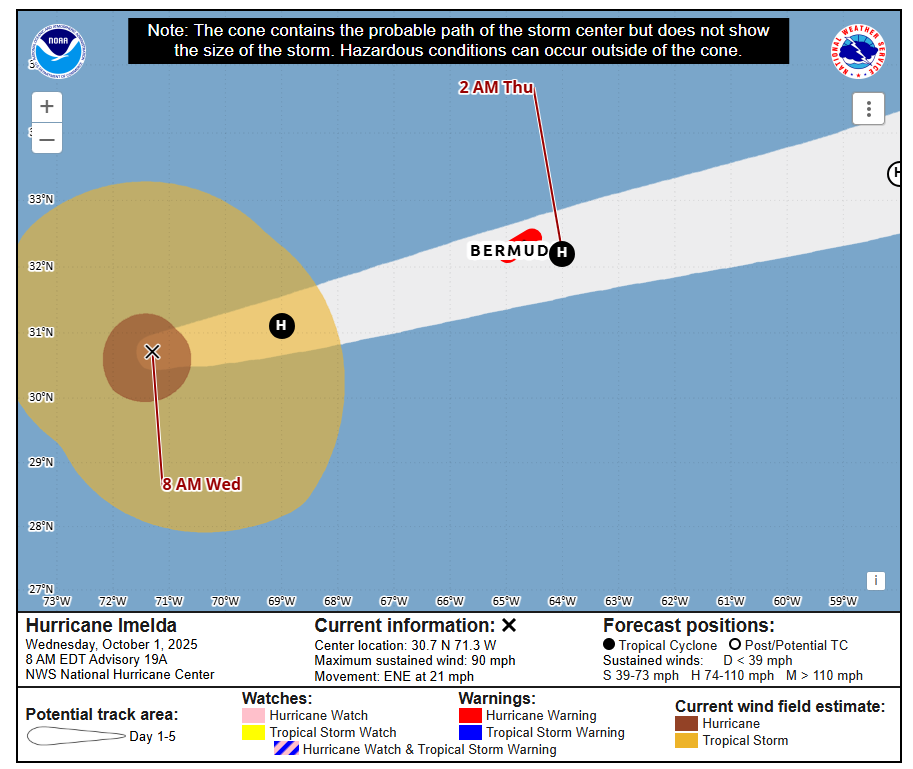
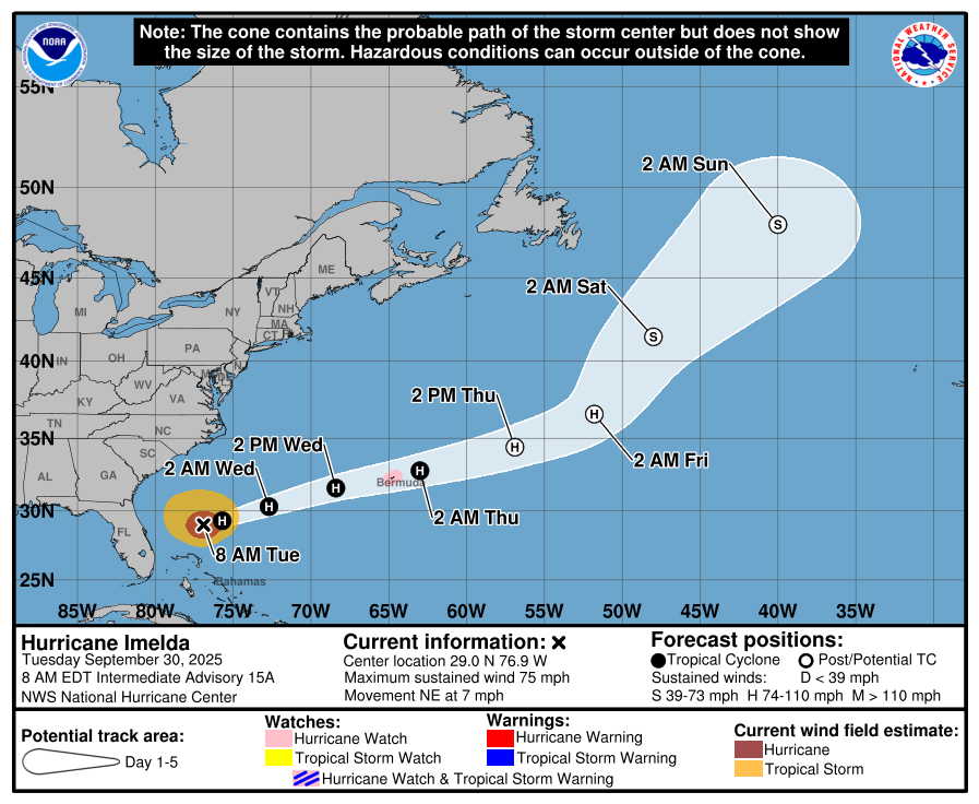
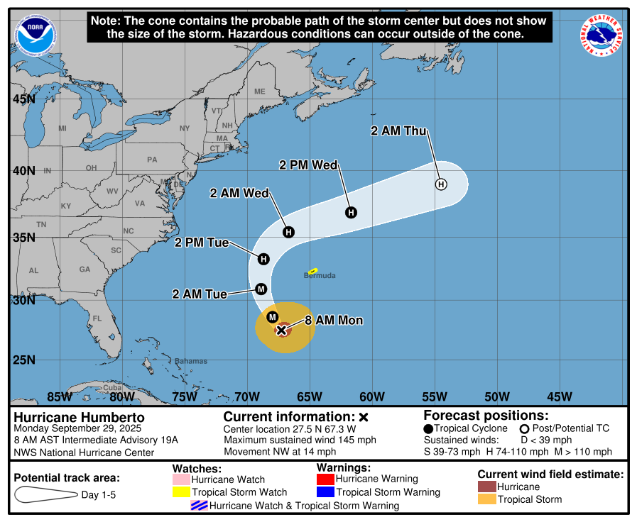
Imelda is a strong category 1 storm, headed for category 2 eventually later today. Obviously, a hurricane warning is in effect for Bermuda, and conditions are expected to deteriorate later today.
Imelda is expected to pass over or very near Bermuda by the overnight hours. (NOAA/NHC)
Imelda’s exact track maybe nudged a hair south overnight, which could push the center south of Bermuda. Either way, and no matter how I write this, it’s going to sound inappropriate, Imelda has a robust backside.
Imelda has a serious western semicircle, which will allow Bermuda to feel hurricane impacts, whether Imelda tracks over or south of the island. (Tropical Tidbits)
So hurricane impacts are almost a certainty on Bermuda. But whether or not we can avoid the potent winds on the southwest side that have been discussed this week as part of a “sting jet” scenario remains to be seen. A track just south of Bermuda probably avoids the worst-case scenario for Imelda specifically, but it still provides plenty of problems.
The good news is that Imelda is moving swiftly, and Bermuda should see calmer conditions and clearing as early as tomorrow morning. From here, Imelda will head further out to sea, not a land threat for now, though the exact trajectory becomes more uncertain in 3 or 4 days.
Imelda & Humberto
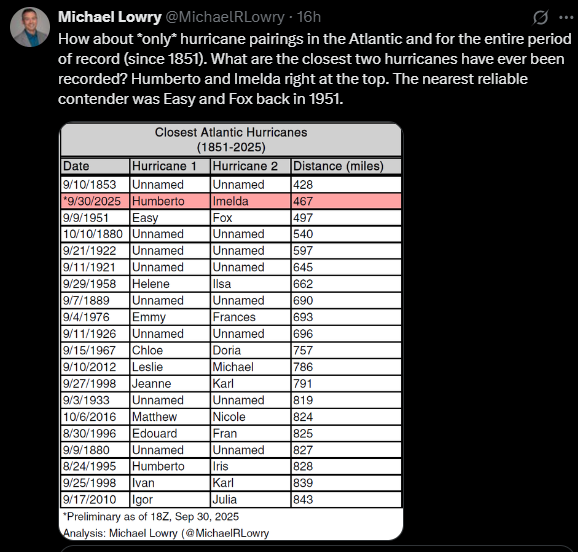
Michael Lowry dug up a great statistic yesterday that showed Humberto and Imelda were the two closest hurricanes in the Atlantic basin in the satellite era.
And, frankly, it’s not even close. We did see them both interact with one another yesterday in a somewhat interesting way, via a bit of a Fujiwhara effect. You can see that on this satellite loop from the College of DuPage. If you look closely, you see Humberto get pulled back north and west a smidge on Tuesday, as Imelda begins to undercut the storm.
Imelda takes over for Humberto in the Atlantic, but Humberto’s remnants will help fuel a major European storm this weekend. (Weathernerds.org)
But is interesting to see the model data showing Humberto and Imelda basically in a little cocoon together last night into today before Humberto just gets wrecked. A fascinating meteorology unfolding in the Atlantic that may make someone’s dissertation one day.
In brief: Imelda will have a complex journey to Bermuda over the next couple days, dealing with both external risks to intensification, as well as jet stream support for its intensification as it transitions into an extratropical storm. The end result: Significant storm impacts for Bermuda are expected, with strong winds and rough seas. Imelda and Humberto will continue to combine for rough seas, tidal flooding, beach erosion, and rip currents up and down the Atlantic Seaboard.
Hurricane Imelda
(NOAA/NHC)
I feel like each day we’ve had some sort of new classification of Imelda. We went from PTC on Friday to depression on Sunday to storm on Monday to hurricane today.
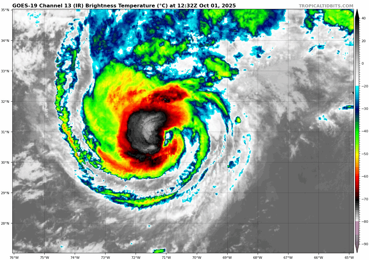
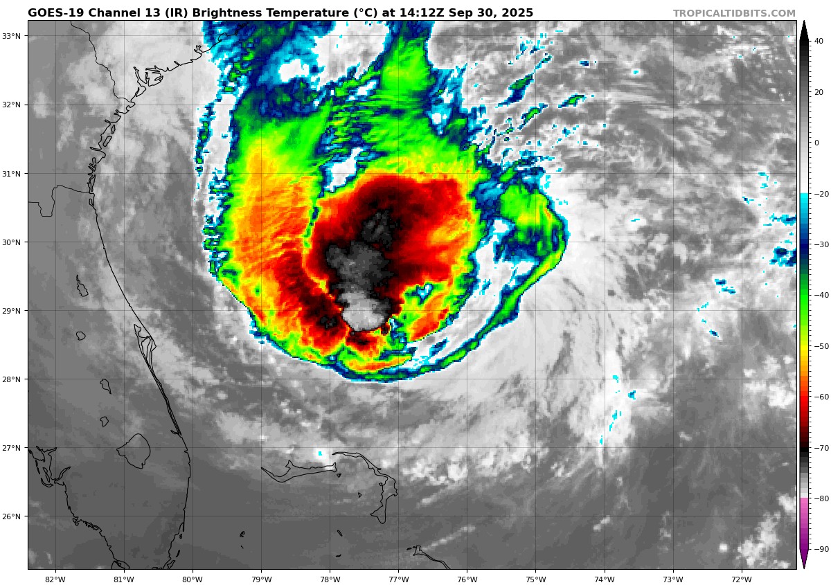
Imelda’s satellite image leaves a bit to be desired this morning, but it’s still a pretty robust storm. (Tropical Tidbits)
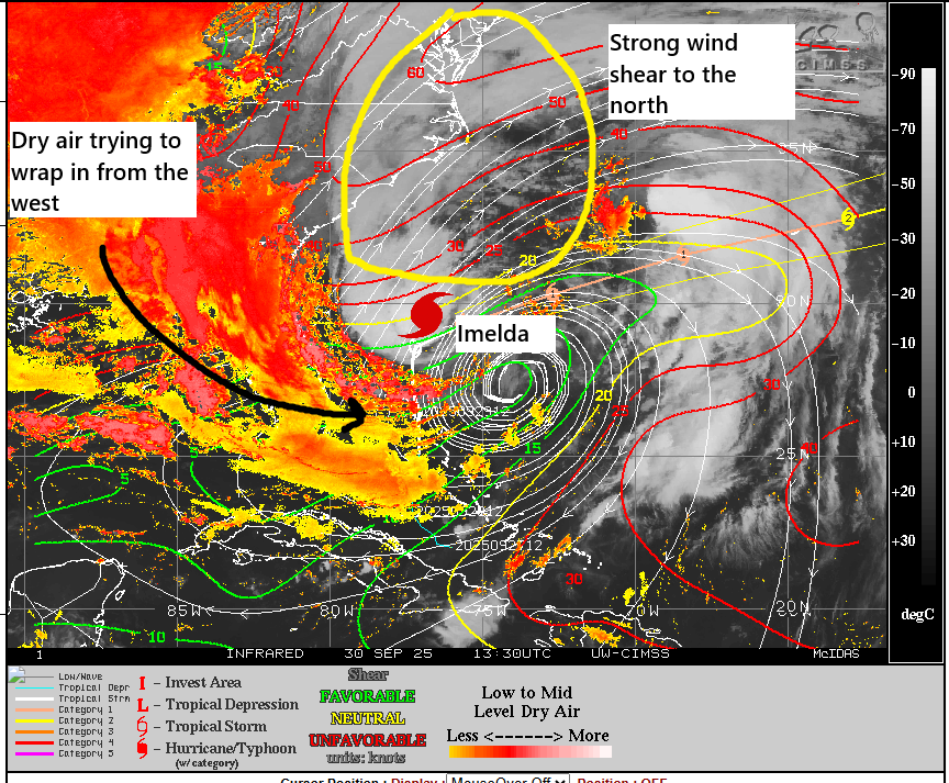
Imelda was upgraded to a hurricane earlier this morning, based on recon data. Further strengthening is expected, however like most everything with Imelda, it’s been complex. In Hollywood parlance: The system itself sits in a nice little cocoon, but it is surrounded by hostile forces seeking to attack and destroy it. Shear and dry air surround half the storm right now, and while it is currently able to strengthen over the warm water, what happens from here is questionable.
Imelda’s environment is…tricky to say the least. (University of Wisconsin CIMSS)
Intensification will probably be modest over the next 24 hours, which would slowly nudge it up the category 1 scale. Odds of significant rapid intensification have dropped today. And the odds of a major hurricane have also. But what is interesting is that as Imelda approaches Bermuda, it will begin to undergo transition to an extratropical storm. And sometimes, sloppy storms like this one just need that nudge from the jet stream to rev them up.
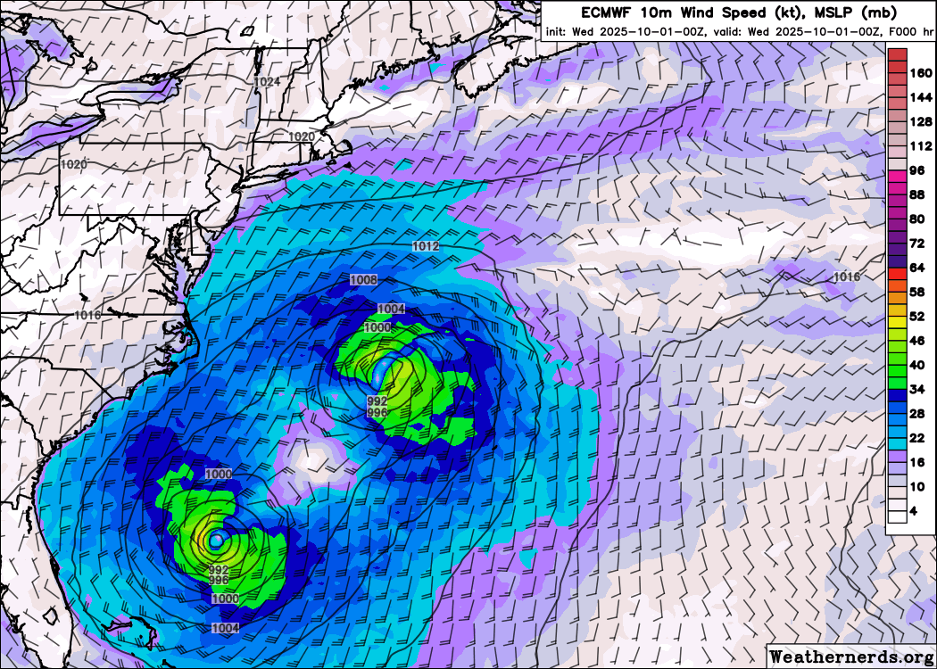
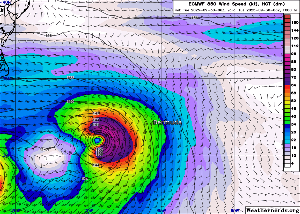
Imelda’s winds will actually increase tomorrow as it approaches Bermuda, even as it slowly transitions from hurricane to powerful extratropical storm. Humberto basically falls apart ahead of it and gets gobbled up by Imelda. (Weathernerds.org)
In fact, you can see the lower-level wind forecast from the European model for tomorrow into Thursday above. Notice how Imelda (approaching from the lower left) sees a burst of wind later tomorrow (winds over 100 mph down to about 5,000 feet based on this outlook). This is what could end up impacting Bermuda as it approaches late tomorrow and very early Thursday morning.
Hurricane Watches are posted for Bermuda, and I would expect those to get upgraded to warnings soon.
Track-wise, there is good agreement on a track that comes close to a direct hit on Bermuda. However, as you see above, the wind field from Imelda is going to be somewhat broad and potent, so the impacts may be similar regardless of the exact track in this instance. Rainfall of 2 to 4 inches is expected in Bermuda, which could cause some localized flooding.
On the U.S. East Coast, the northern shores of the Caribbean, the Bahamas, and parts of Atlantic Canada, there will continue to be rough surf, beach erosion, rip currents, and tidal flooding risk as a result of both Humberto and Imelda. This will take a couple days to subside. Caution is continued to be advised.
Elsewhere, Humberto is on the way out, as noted. We should have a breather after Imelda dissipates later this week. We’ll then turn our attention to whatever comes next, which may or may not be in the Caribbean. Model “noise” is inching up a bit late, but there remains no real signal. Good news for now.
In brief: Imelda continues to look to confidently turn away from the Southeast this week, but the threat to Bermuda has increased a good bit. Imelda will likely strengthen into a formidable hurricane as it exits toward Bermuda. Humberto should graze Bermuda with some gusty winds and rain before that occurs. Rough surf, tidal flooding, and beach erosion will all be possible on the Eastern Seaboard.
Tropical Storm Imelda
Just as a side bar: For our Texas readers, you may very well remember Tropical Storm Imelda in 2019, which was just a gutting storm for parts of the region, especially east of Houston through Beaumont. Nearly 45 inches of rain fell just southwest of Fannett between Winnie and Beaumont. Despite this, the name was retained for future storm lists. Over $5 billion in damage was caused by Imelda, and the only more damaging storm to not have its name retired was Hurricane Sally in 2020. I have opinions about that decision, but I’ll leave it there. We have a new Imelda now, and that’s what we’ll focus on.
Tropical Storm Imelda is expected to become a hurricane tomorrow as it turns northeast away from land — for now. Bermuda will want to follow this closely. (NOAA/NHC)
This morning, Imelda is gradually organizing in the Bahamas. It looks rather impressive on satellite, but that’s not yet translating into intensification per the Hurricane Hunters flying the storm earlier this morning. But it would appear the “bones” are in place to build a more organized, intense storm in time.
Imelda isn’t yet intensifying much, but it’s getting better organized this morning. (Tropical Tidbits)
Imelda will slowly intensify today or tonight before perhaps undergoing a burst of more rapid intensification tomorrow. The NHC tops Imelda off at a high-end category 1 storm on Wednesday or Thursday, while some of the model guidance is pushing category 2 now. Unfortunately, it appears that the peak intensity will occur around the time the storm is approaching Bermuda. Simultaneous to this, Imelda will be transitioning from a purely tropical storm to an extratropical storm. As this occurs, it’s possible that Imelda will maintain or even enhance its wind profile some.
The takeaway in all this? Bermuda should be following Imelda closely.
For as much heartburn as Imelda’s track caused us last week, the models are in strikingly decent agreement today.
Imelda’s track is high confidence through about 72 hours as it approaches Bermuda. Confidence drops a bit beyond that. (Polarwx.com/Tomer Burg)
There is very strong model agreement in a hard right turn as Imelda strengthens and follows Humberto. Exactly where it passes Bermuda, a tiny speck in a large blue sea remains to be seen, and that is important. While we tell folks not to focus so much on the track specifics, these sorts of close passes can mean the difference between moderate or more severe impacts. So again, Bermuda should pay attention, and we may see hurricane watches hoisted there by tonight.
In terms of the rainfall from Imelda, welllllll.
Rainfall is now not expected to cause serious problems in the Carolinas. (NOAA/WPC)
We could see as much as an inch or two on the immediate coast between Charleston and Wilmington, but otherwise, most places should see less than an inch, probably even less than a half-inch. Back on Friday we noted that the GFS model, which kept the storm offshore and delivered notable but lower-end rain totals was a nice “floor” forecast. Turns out even that was too much. But this is why you never settle on one model and one outcome, particularly before a storm develops. There’s a reason we couch our forecast words in time-sensitive language like “for now,” “at this time,” or “currently.” It’s an evolution, not a guarantee. I don’t think too many folks in the Carolinas will complain.
There will be impacts between Humberto and Imelda for rough surf, tidal flooding, and beach erosion. Minor to moderate tidal flooding is expected from the Charleston through Norfolk areas, perhaps even up to the Jersey Shore. This will pick up by Wednesday and Thursday.
Tidal forecast in the Norfolk area this week. (NOAA/NWS)
In addition to all this, rip currents are going to be significant issue along most of the Eastern Seaboard through the week. Again, if you’re a surfer, be aware and safe as most of you always try to be. Others should ensure they are only swimming on beaches that have lifeguards and follow all flags and warnings.
Hurricane Humberto
Humberto remains a major hurricane this morning, with maximum sustained category 4 winds of 145 mph.
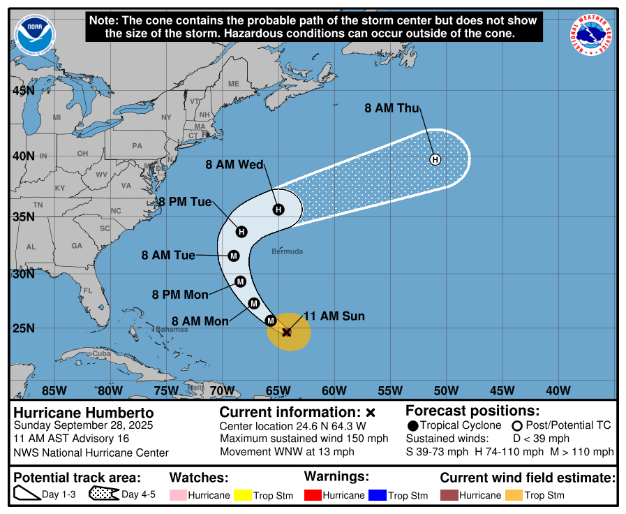
Humberto should begin weakening soon, but it may still deliver tropical storm conditions to Bermuda on the way out ahead of Imelda’s arrival. (NOAA NHC)
Humberto will gradually be weakening in the coming 48 hours, but as it passes Bermuda, it will deliver some gusty winds and a couple inches of rain prior to Imelda’s much stronger impacts Wednesday night and Thursday. Humberto offers some valuable lessons that we will get into later this week.
Elsewhere
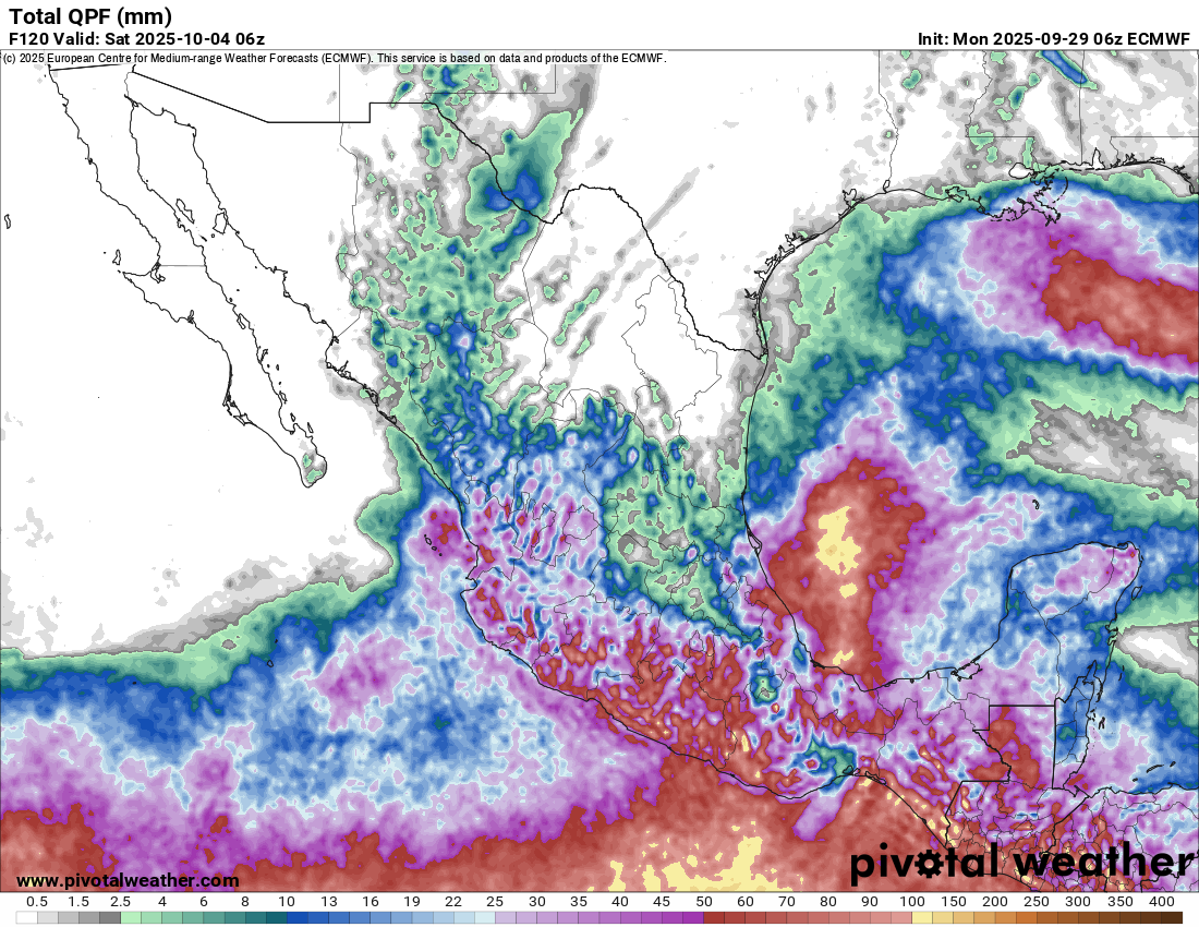
Other than some extreme warmth across parts of the country, with places like Minneapolis expected to be 20 to 25 degrees warmer than normal later this week, it’s quiet. There’s a flood watch in the Ruidoso area in New Mexico due to some potentially locally heavy rain there. There is a weak disturbance in the Gulf that’s expected to drop south into the Bay of Campeche and eventually Mexico, so some heavy rain is possible with that.
Up to 100 mm of rain is possible for parts of Veracruz perhaps over the next 5 days. (Pivotal Weather)
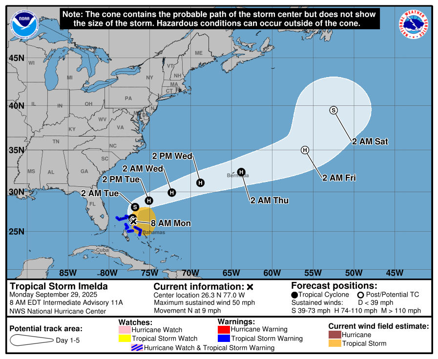
In brief: Tropical Depression 9 is still expected to become Imelda by tonight. The track forecast has shifted farther south and east, keeping it farther off the Southeast coast. Still, heavy rain and marine impacts are a good bet on the coast of the Carolinas, but some “stand down” measures can be taken now it appears. Also, today we discuss Humberto’s journey to category 5 intensity and the broader context of a marine heat wave.
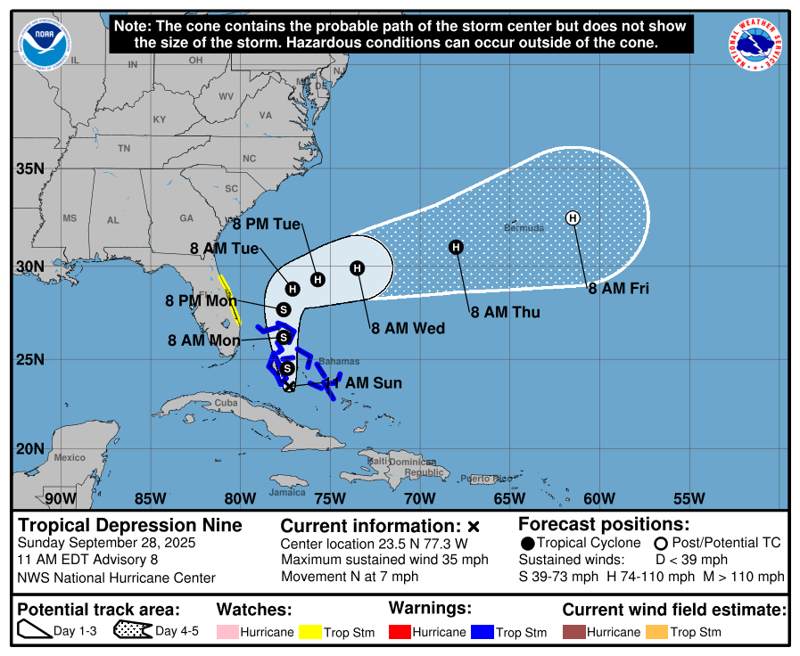
Tropical Depression 9
11 AM ET forecast for TD 9 (NOAA/NHC)
Trends since yesterday have generally been a continuation of trends since Friday, which is to say that threat of a high-end impact to the Carolina coast is diminishing. Friday’s forecasts were far more foreboding in terms of a stalling rainfall event for the region. But since then, all trends seem to have nudged the center of TD 9, presumably Imelda farther from shore. To be clear, this doesn’t mean there will be no impacts, nor any significant ones. It just means the risk of severe, widespread flooding and higher-end wind has dropped a lot in 2 days.
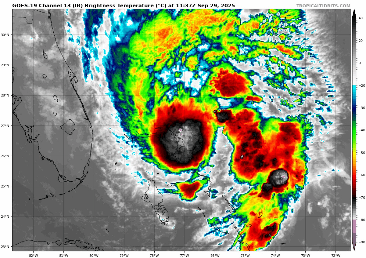
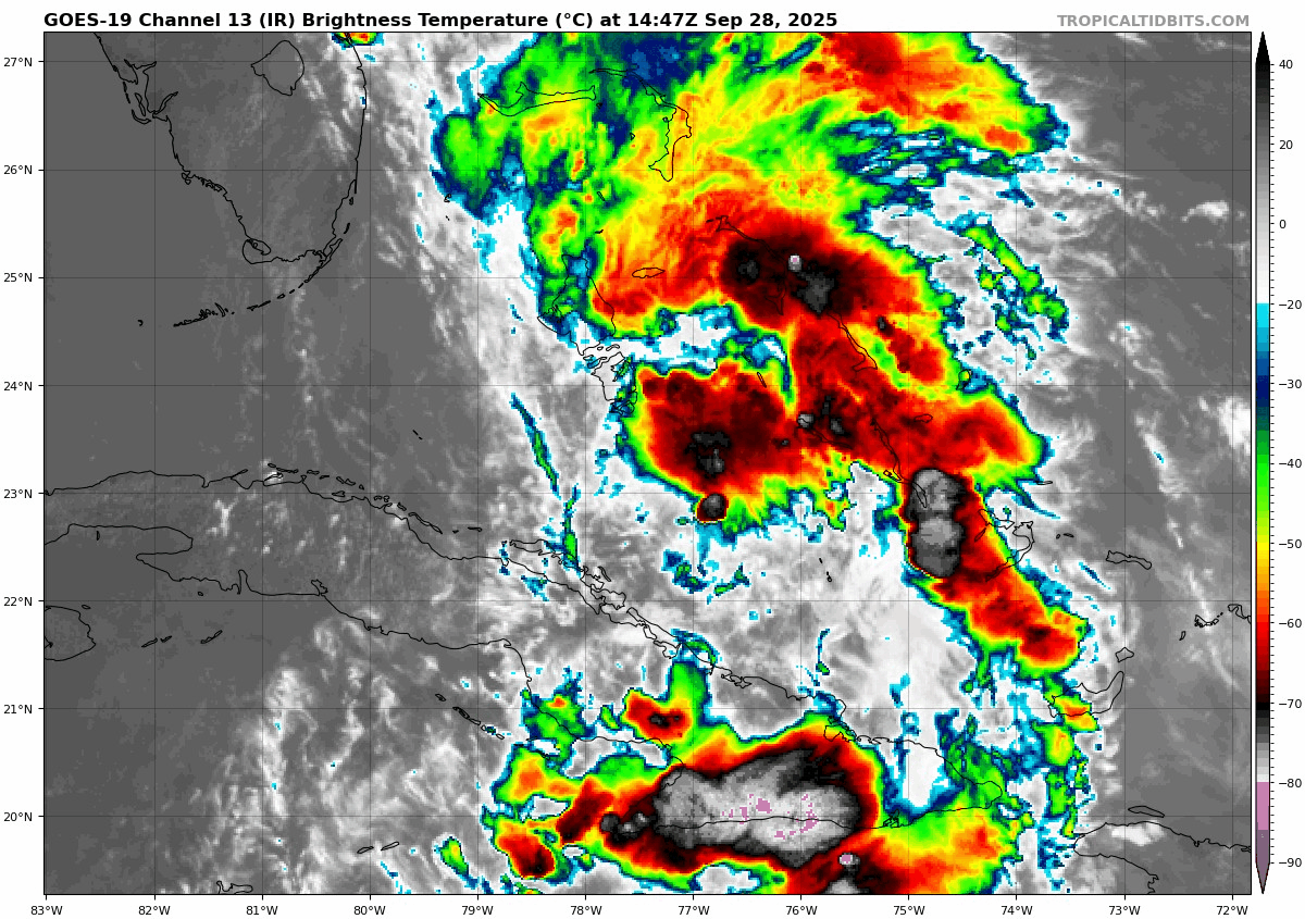
Tropical Depression 9 is a bit jumbled over the Bahamas, but in general it’s trying to push toward tropical storm intensity. (Tropical Tidbits)
Over the next 24 hours, we do expect to see TD 9 begin to “find itself” in the Bahamas, as many of us probably wish we could also do. Expect a slow strengthening in the next 24 hours, followed by a slightly more aggressive intensification from tomorrow morning into Tuesday, taking TD 9 to Imelda and then a hurricane, possibly a category 2 type storm by later Tuesday or Wednesday. Assuming the wind shear it will likely fend off doesn’t become a prohibitive limit on the ceiling, like we saw with Humberto (more below), we could see this push beyond current consensus intensity forecasts.
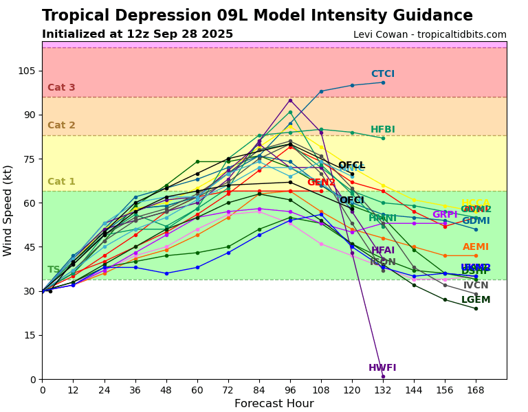
Various model intensity forecast for TD 9 with most in tropical storm or category 1 range. (Tropical Tidbits)
You can see how the HWRF (HWFI) and HAFS-B hurricane models bring this into category 2 or 3 range. With the lumbering Humberto in the vicinity, there’s certainly uncertainty in this, but generally speaking with hurricanes, it’s been like a good old fashioned Big 12 slugfest, and the “over” for intensity has generally won this season.
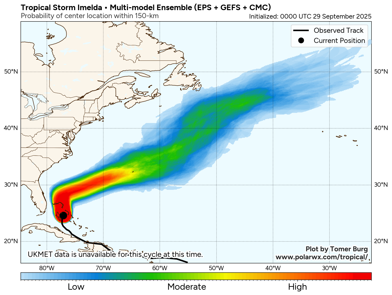
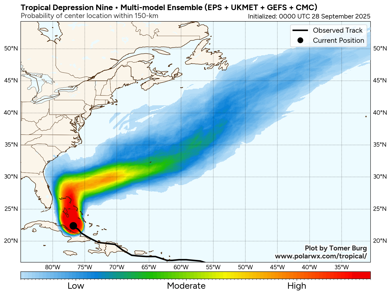
Model agreement on the track of TD 9 has also increased significantly since yesterday.
There is still a very small subset of ensemble members bringing TD 9 closer to the Carolina coast than we’d like, but the vast majority take a hard right just before it gets to 30°N. (Polarwx.com/Tomer Burg)
We have far fewer outliers closer to the Carolina coast. Most make a hard right now south of 30°N latitude, allowing it to exit without a ton of consternation. You can also see this reflected in the “trend” of the consensus model since yesterday morning, continuing a trend from Friday.
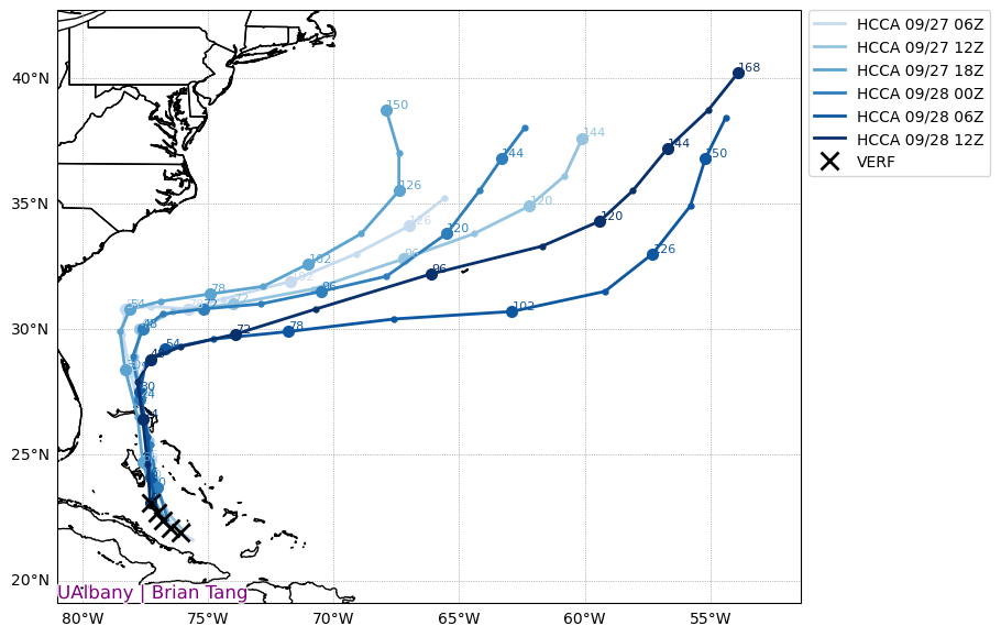
Consensus guidance for TD 9 has been trending south and east with time in the next 72 hours of the forecast, keeping the system farther from the Carolinas. (Brian Tang/SUNY Albany)
The lighter colored tracks above are older forecasts, while the darker ones are newer forecasts. You can particularly between hours 30 and 72 that there is a sharp deviation to the southeast from older runs to newer runs. Basically, with respect to the Carolinas, TD 9 continues to trend farther away, good news to be sure.
Could this change? Of course. But we really have not seen any reliable model guidance continue to threaten the Carolinas severely. So you should obviously keep monitoring the forecast, but it’s ok to exhale sometimes.
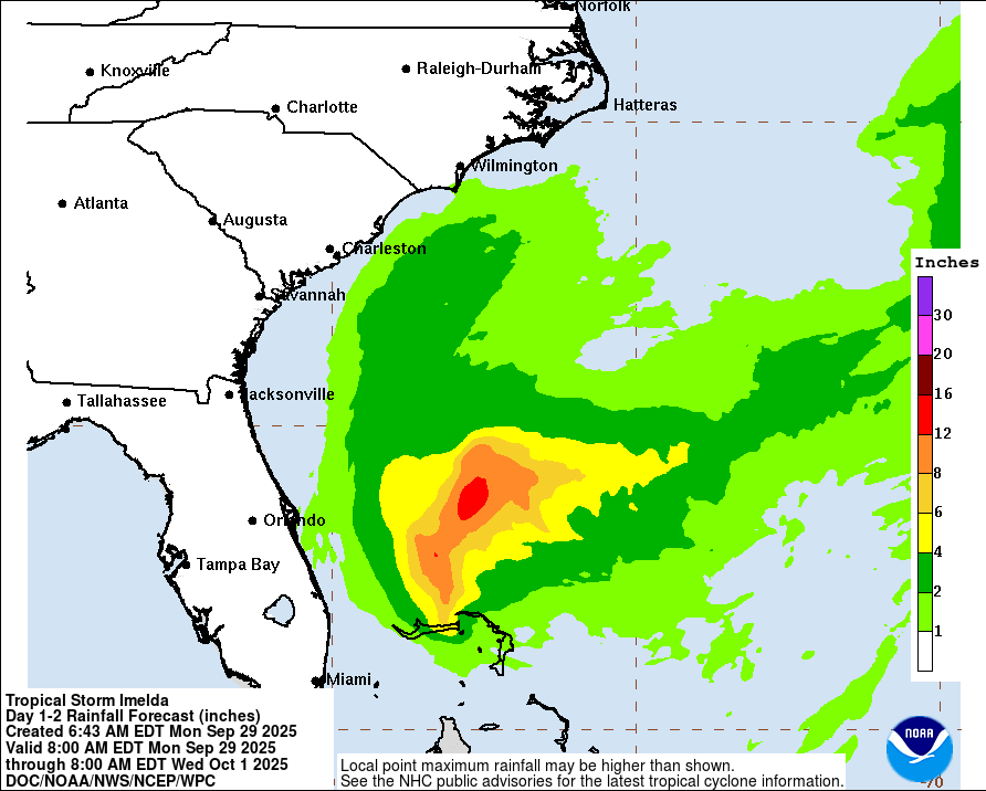
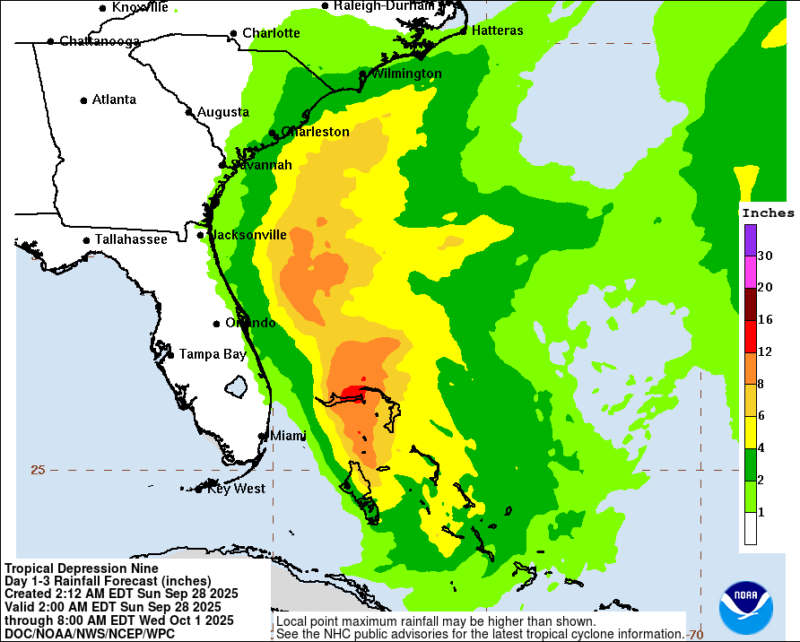
What of the rainfall forecast? Well, the official forecast looks like this:
The rainfall forecast for Tropical Depression 9, through Wednesday morning. (NOAA/WPC)
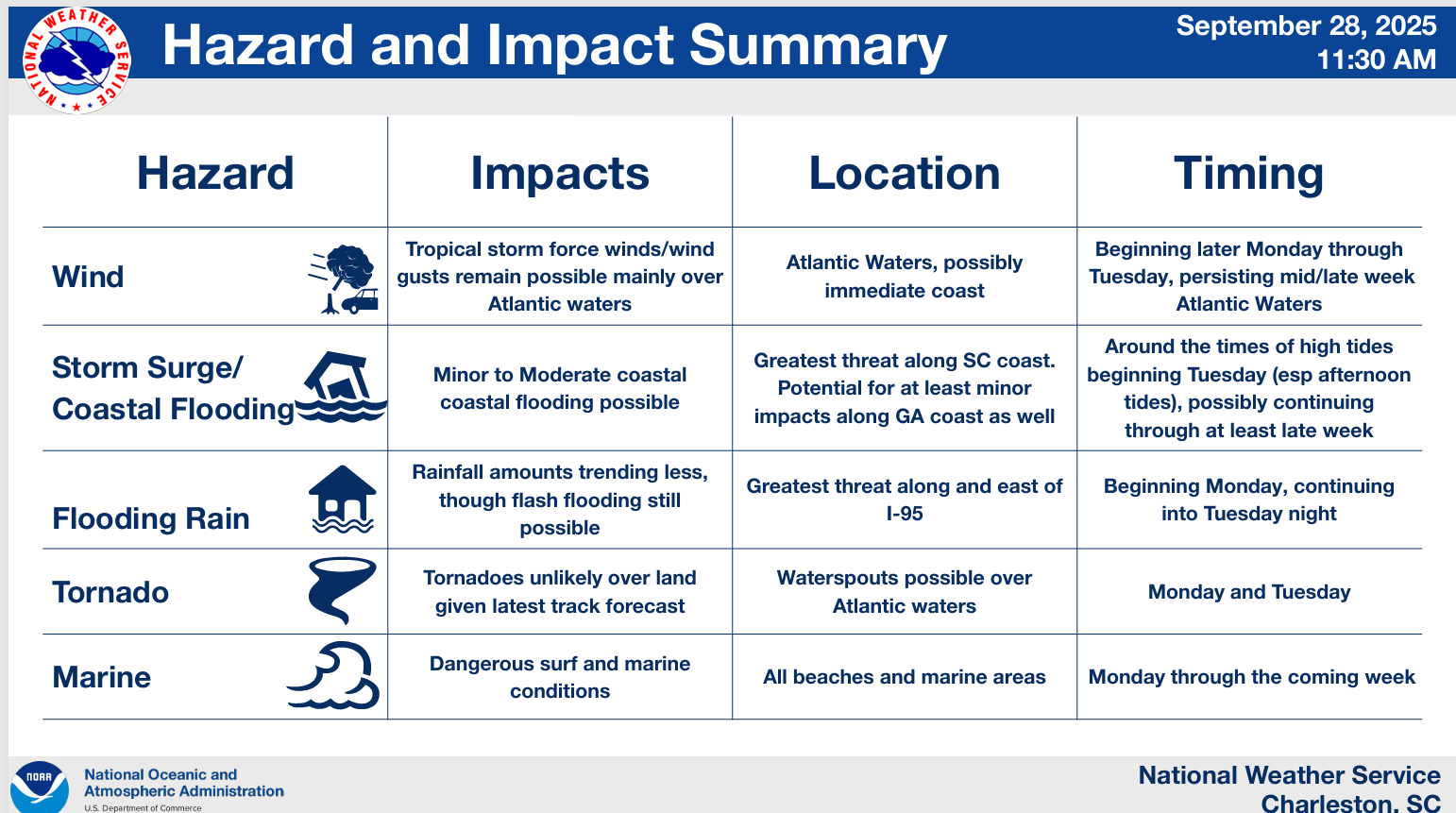
At least through Wednesday, which should cover about 90 percent of the storm, rain totals are expected to be around 2 to 4 inches in Charleston, Myrtle Beach, and Wilmington, with lesser amounts surrounding that. Some higher amounts are possible, and slight risks (2/4) are in place for flash flooding tomorrow and Tuesday. The NWS office in Charleston has a helpful chart outlining the impacts for their area. Suffice to say, conditions to the north and south of there won’t be terribly dissimilar.
An impacts chart from the NWS in Charleston. (NWS Charleston, SC)
The most significant overall impacts will be marine-related with rough seas from both TD 9 and Humberto churning up high waves, beach erosion, and extremely dangerous rip currents. This will expand up the East Coast in time over the next day or two as well. “Locals season” as we called it on the Jersey Shore should probably involve more observation from land than going into the water. If you’re a surfer, exercise extreme caution.
Interests in Bermuda should continue to monitor TD 9 over the coming days. You’re now in the higher uncertainty part of the forecast, with a track spread mostly south of the island, but close enough to keep you sitting up and paying attention. More to come on this through the week.
Humberto becomes our 2nd Category 5 storm
Since 1980, the era of decent satellite observation, we have had 25 category 5 hurricanes in the Atlantic Basin. Almost half of those (12) have occurred since 2017. Make of that what you will. The newest entrant is Humberto, which surged to category 5 intensity yesterday.
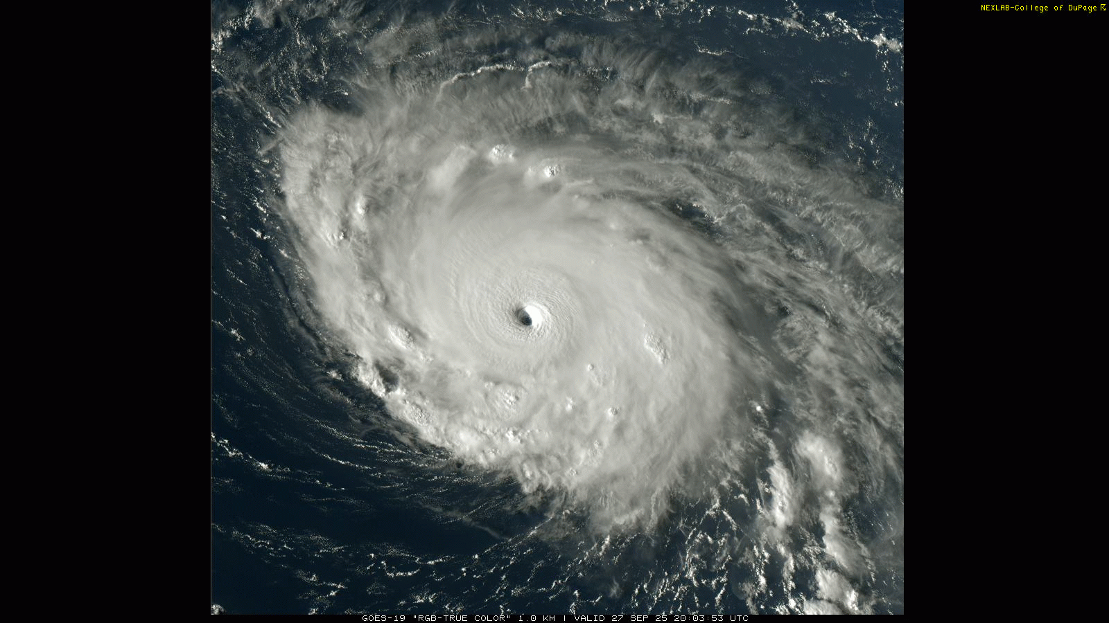
A satellite image of Humberto near peak intensity on Saturday. (College of DuPage)
Humberto is back down to a category 4 today, as the eye has filled in some, and it appears to be undergoing an eyewall replacement cycle. Category 5 storms don’t usually stay there for too long, though some have sat there for 3 days (most recently Irma in 2017).
Thankfully, Humberto is still expected to push out to sea without much fanfare other than the wave action it will continue to produce for Bermuda and the East Coast and Bahamas.
(NOAA/NHC)
Humberto is not currently expected to impact the Azores.
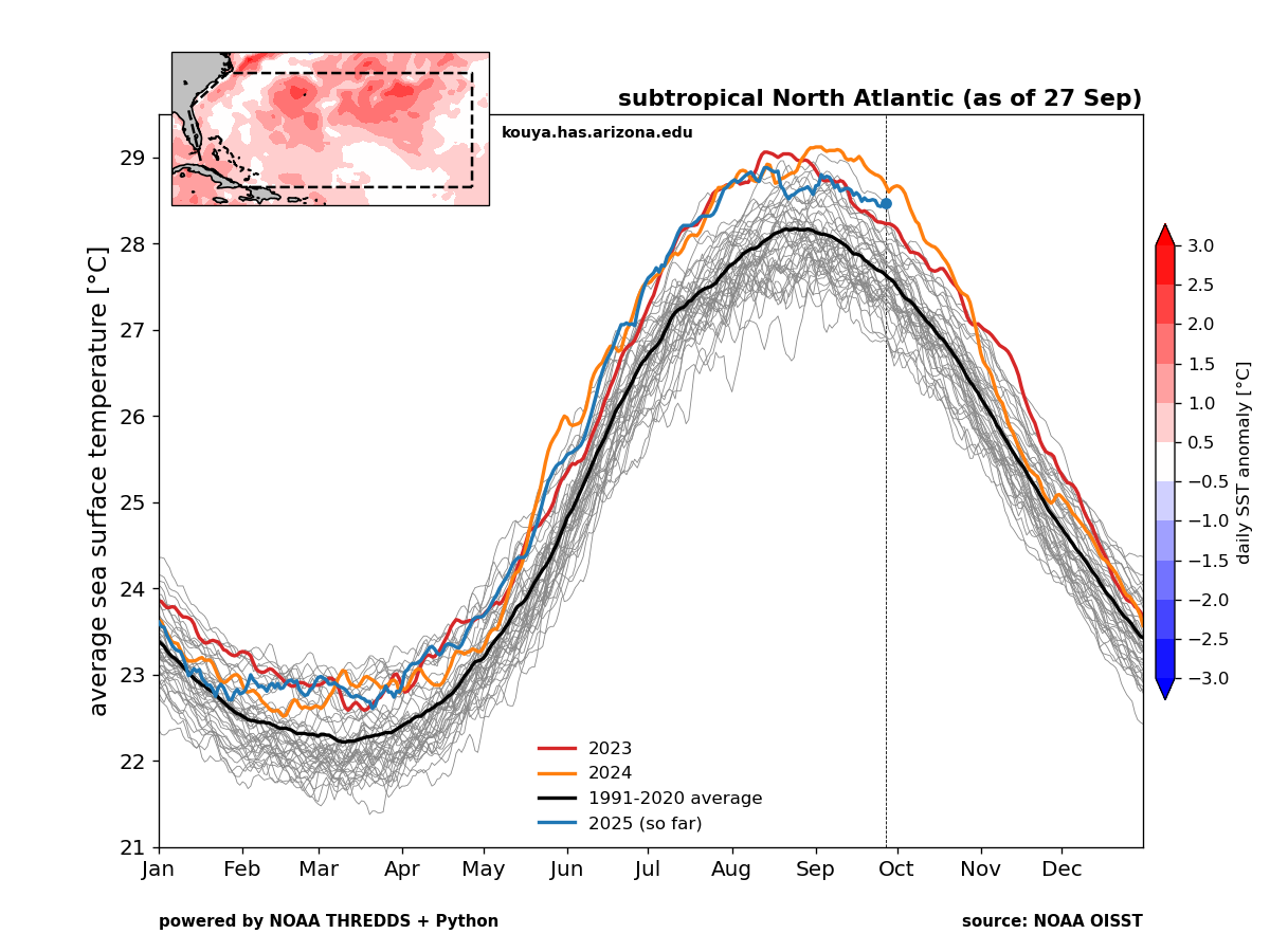
Warm ocean context
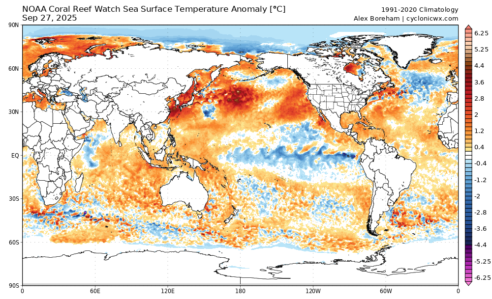
I sort of jokingly said “make of that what you will” up top. But the reality is that the Atlantic subtropics, where both Erin and Humberto popped to category 5 this summer are near the top of the scale of warmest on record.
The Caribbean and the Gulf are doing the same, but mercifully we have not yet had a meaningful system there this summer and autumn. And it’s not just the Atlantic. Global water temperatures are about 0.5°C warmer than normal on average. You can definitely pick out some cooler pockets here and there, but the reality is that most of the global oceans are running a fever.
Global sea-surface temperature anomalies. (Cyclonicwx.com)
You can see that this is especially true in the North Pacific, eastern Indian Ocean, Barents Sea, Norwegian Sea, Gulf, Caribbean, and subtropical Atlantic. The only meaningful cool anomalies are in the western Indian Ocean, El Niño region (Hello, La Niña?), and far north Atlantic. The North Pacific marine heat wave (colloquially called “the blob”) is a big story, and one that may have further implications on weather heading toward winter. It’s already notable in California.
The reality is that the oceans are continuing a heat wave that began a few years ago, and it’s almost certainly been having some impacts on the intensity of Atlantic storms — and beyond.