Headlines
- Milton made landfall near Siesta Key earlier this evening.
- Storm surge of 8 to 10 feet is likely to have occurred near Sarasota through Venice.
- Surge of 5 to 6 feet is causing major flooding in Fort Myers, Naples, Punta Gorda, and elsewhere down the coast.
- Tampa Bay was spared the worst case scenario surge.
- But major to catastrophic flash flooding is now ongoing in the Tampa metro area, with torrential rain expanding north and east up I-4 toward Orlando.
- Over 1.5 million customers experiencing power outages now in Florida.
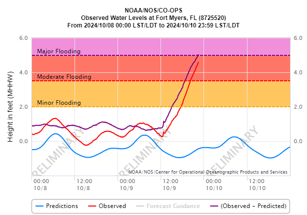
Hurricane Milton made landfall near Siesta Key this evening as a category 3 hurricane. An approximately 10 foot storm surge came ashore in Sarasota, while Tampa Bay ranged from negative surge (water being flushed out of the bay) in the upper part of the bay to about 2 feet in the lower part. Had Milton made landfall even 15 to 20 miles farther north, we’re talking about a 10 to 12 foot surge into Tampa Bay. That’s how close it came for Tampa…20 miles. Farther down the coast, about a 5 to 6 foot surge is ongoing in Fort Myers. There are videos from Venice floating around showing pretty terrible surge as well. So I presume daylight will bring a pretty rough scene in Sarasota, Venice, and Longboat Key, among other places.
Relentless rain is pounding the Tampa metro area and now spreading north and east across the Florida Peninsula. Totals for today have been up to 17 inches in St. Petersburg and over 10 inches around much of Tampa.
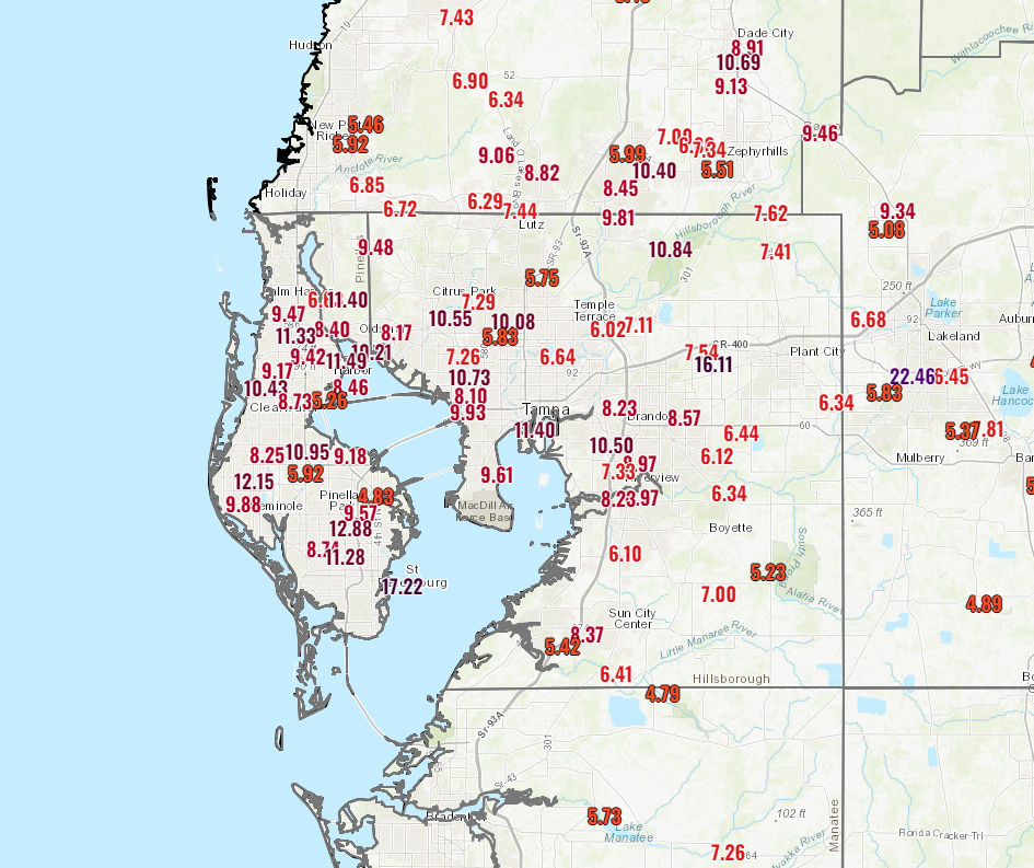
There’s still a good deal more rain to come though hopefully the pace will slow somewhat. A flash flood emergency is in effect in Tampa. Catastrophic flooding is possible from the rainfall. This may not be the last flash flood emergency we see this evening, with torrential rain working northeast on I-4 toward Orlando and Deltona.
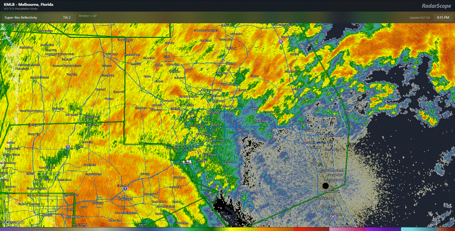
Several inches of rain will fall in a short time here, and severe flash flooding may occur. Thankfully, the tornado threat has pushed offshore for now, and though an isolated tornado can’t be ruled out there should not be the ridiculous pace we saw earlier today. The damage in eastern Florida from tornadoes is going to be more significant than we typically see in a tropical system. Why this storm went ballistic whereas other do not is a complex topic to get into but perhaps one we can touch on during the offseason.
Next update will be in the morning sometime. Wishing all the best in Florida.
Thank you for providing the most informative and easiest for the layperson to understand coverage of Hurricanes Helene and Milton. It is much appreciated!
The NHC forecast on this hurricane was excellent and gave Floridians great service. I wonder how much AI technology will help future forecasting? Or is the quality limited by the ability to collect the breadth of data points necessary for improvement in modeling?
Would be grateful for info on the storm surge level at Siesta Key. Thank you.
I remember watching GFS to see what Helene would do, but kept seeing a signal for a new storm spinning in the WC or BoC heading for Florida in over a week that was not Helene. Well there’s a new signal on GFS for a storm spinning in the WC and heading for Florida in over a week that is not Milton.
2004 was crazy, but 2005 was even crazier. Let’s hope that 2024-2025 doesn’t repeat that pattern.
MJO: What I’m seeing right now is some kind of low pressure syster in the WC around the 17th meandering around and eventually making it into the southern Gulf, still meandering.
How long are we going to ignore and avoid even mentioning the elephant in the room? This is dereliction of duty on your part. Why so afraid of those who’ve made science and reality their enemy? Why, Matt?
Asheville was heavily damaged. Biltmore was flooded. People died. … In 1916.
The Spanish treasure fleet carried resources from Spanish colonies in the America’s to Spain for two and a half centuries (1600s and 1700s). There were more vessels lost to hurricanes than to pirates. The Spaniards did not have the benefit of modern satellites and computer models. And so to this day men seek fortunes recovering Spanish gallons sunk by hurricanes.
Hi Jack. https://theeyewall.com/trying-to-make-sense-of-the-flurry-of-strong-hurricanes-in-the-gulf-of-mexico-since-2017/ Thanks for the feedback!
And one more historical tidbit. If you drive southwest from Houston to Matagorda Bay you can see a historical marker for the once thriving port city of Indianola, Texas. If you have not heard of this city, it is because the port was destroyed by hurricane in 1875 (with over 150 deaths), then rebuilt, then destroyed again in 1886, then abandoned.
I’m thinking it was the rich moisture pulled up with the eastern outer rainbands along with the vertical shear causing those tornadoes, along with the timing during peak heating hours that did them in. I wonder if there are any publications that link a sheared hurricane at landfall with increased tornadoes.
Having lived in Houston during hurricanes, and using SCW as a resource, and now living in Florida for a hurricane using Eyewall as a resource, the differences between the two are apparent. Whereas SCW is a more focused tool, with 3-6 posts per day for several days surrounding a hurricane approaching Houston, Eyewall is more of a relaxed blog to inform Houston residents of things happening elsewhere. It’s still helpful, but it’s not going to hang on every NWS update like it would for a Houston event. I’m not complaining, but maybe a little disappointed that I don’t have a similar tool to rely on when hurricanes hit my new home.
quote: “it’s not going to hang on every NWS update like it would for a Houston event.” end quote.
That’s because SCW and The Eyewall are focused on the surrounding Houston area. 👍
We’re actually not trying to do a SCW for everywhere…that’s impossible because we lack the local knowledge that only someone living a different place has. I thought we talked a lot about impacts, even specific ones in the run up to Milton with at least 2 posts a day. The reality is, not much changes in between. Or at least not much to constantly hit you with. So we aren’t so much relaxed as we are disciplined and trying to make each post carry weight rather than just sending you a notification that we’re still here watching. Also, we aren’t informing Houston residents of things elsewhere. We’re trying to reach people in other areas to let them know when to care about certain storms or when they can safely exhale a bit. I want this site to be a primary source of info for folks in the 3+ day out timeframe before a storm or weather event. Inside 3 days, yes, follow us too. But you need to also follow local folks who know the area better than we ever could. We don’t want to pretend we know more than we do!
Ahh, I didn’t realize EW was primarily a 3+ day tool. Thanks for the response.