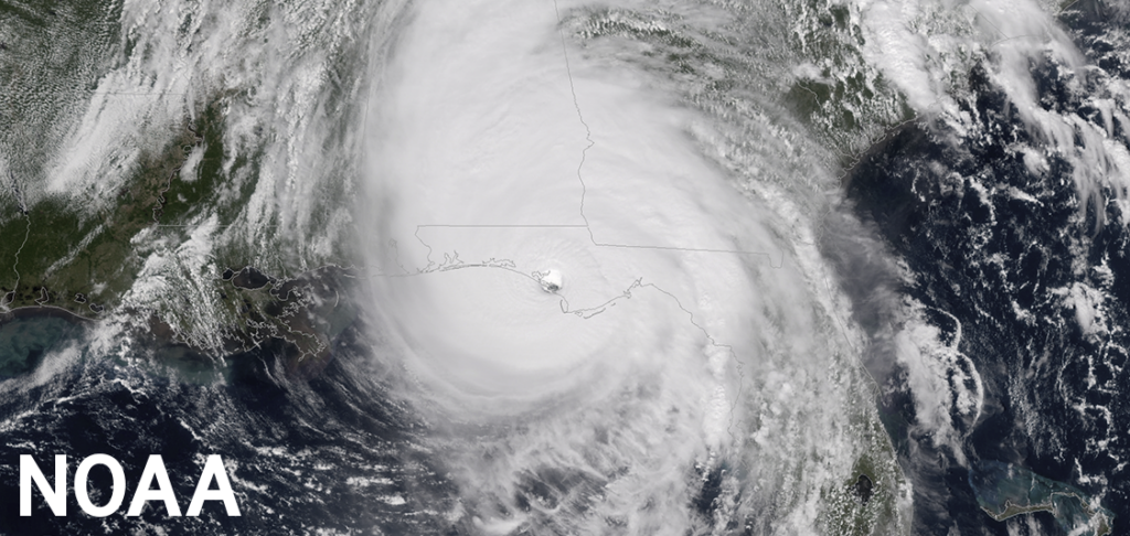
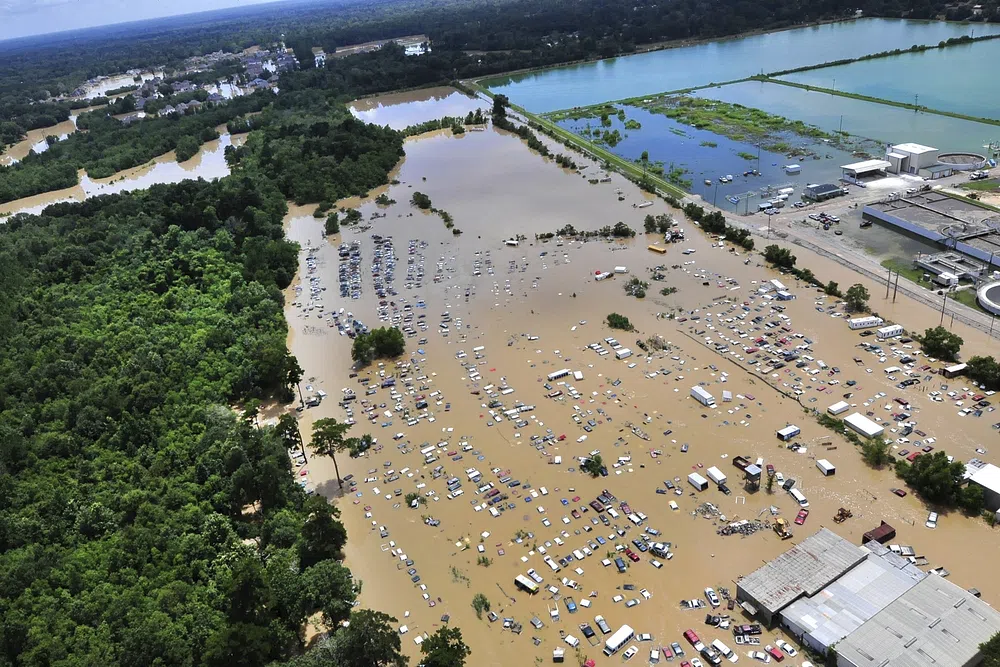
At The Eyewall, our focus will be extreme weather of all types. But initially, we will stick with what we know best, which is tropical weather. As the 2023 Atlantic Hurricane Season gets underway, it is obvious that residents along the coast of the Gulf of Mexico are on heightened alert. When Hurricane Harvey devastated the Coastal Bend of Texas and flooded Houston and the Golden Triangle in 2017, it marked the beginning of a trend that has become uncomfortably common in the years since: Gulf storms have been finding ways to rapidly intensify, often up to the moment of landfall, striking the coast at or near their absolute worst.
After Harvey, Hurricane Michael devastated parts of the Florida Panhandle in 2018 as only the fourth landfalling category 5 hurricane on record in the Mainland United States. Hurricane Laura came into southwest Louisiana as a high-end category 4 storm in 2020, strengthening up to landfall. Hurricane Sally later that year also managed to intensify up to landfall in Alabama. Hurricane Zeta hit the New Orleans area late in that season, rapidly intensifying up to landfall. In 2021, Hurricane Ida crashed into southeast Louisiana as a strong category 4 storm. And of course, last year Hurricane Ian hit southwest Florida just past its category 5 peak.
All of this raises the question: Why? Is this a new normal? Is climate change “loading the dice” for this to happen more frequently? Is it bad luck? Is the Gulf Coast facing an existential crisis of sorts? A pile of research has dropped in recent years that paints an uncomfortable but murky picture for the Gulf Coast.
Editor’s Note: For those of you that want to dive into this research, we go deep into things below, with links to research papers that have been published in recent years on this topic. We spoke to several researchers in the field who provided guidance and help while we dug into this. But here at The Eyewall, we also pride ourselves on being to the point. What’s the takeaway? What matters?
One-sentence summary
While the storms of the last few years in the Gulf fit some of what research says about climate change and future hurricanes, we cannot confidently say that this is the beginning of a new trend and it is more likely that these themes represent season to season variability.
Key messages
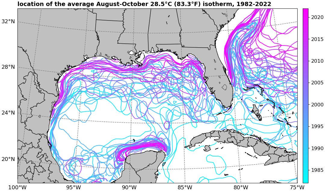
- The Gulf of Mexico is undergoing a warming trend.
- Research strongly points to storms getting stronger, faster (rapid intensification) globally.
- Over the next 50 to 75 years, the research strongly suggests that the Gulf will become more hospitable to higher end, faster intensifying storms due to climate change, along the lines of what we’ve seen since 2017.
- Variability across basins and within basins make it difficult to say with high confidence how climate change will actually affect those future storms in specific places.
- Researchers have keyed in on a trend of slowing of storms at landfall, increasing the potential for heavy rain and freshwater flooding, in addition to higher storm surge driven by increasing sea levels and coastal land subsidence.
So to answer the questions: We cannot say with any confidence that this is a new normal, and for all we know it may just be a function of bad luck and seasonal variability. But the research implies that the future will feature more seasons like those recent ones for the Gulf of Mexico. While there is much focus on intensity and wind, there is growing confidence in the theory that storms are slowing more at landfall, which is leading to rainier outcomes with more flooding.
For more details on the specific research and what it says, read on.
More storms, getting stronger, faster
Scientific questions are usually complex and multi-faceted, and this is no different. For one, the Gulf has seen storms intensifying up to landfall, coming ashore at or near their peak intensities. Tangential to this, storms are intensifying more rapidly, more often in the Atlantic Basin, which includes the Gulf of Mexico.
In 2019, a group of authors led by Kieran Bhatia of Princeton and NOAA at the time, published an article in Nature Communications which took tropical systems from 1982 through 2009 and determined that there were significant increases in intensification rates in the Atlantic Basin that were unusual when compared to model estimates of internal climate variations. In other words, according to that study the data argues that storms were getting stronger faster in the Atlantic, beyond natural variability alone. Bhatia (now with Guy Carpenter) and his co-authors published another article in Nature Communications last November that suggests the likely culprit of these observed changes comes from “anthropogenic forcing,” or climate change.
“Furthermore, thermodynamic environments around tropical cyclones have become more favorable for intensification, and climate models show anthropogenic warming has significantly increased the probability of these changes,” write the authors. Their updated study looked at storms from 1982 through 2017, and it was determined that the Atlantic basin saw a very significant increase in the proportion of cases where a storm had conditions that could have supported rapid intensification.
But what about the Gulf of Mexico specifically? In 2017, Kerry Emanuel of MIT published a timely paper in the Bulletin of the American Meteorological Society (BAMS) entitled “Will Global Warming Make Hurricane Forecasting More Difficult?” His work found that the most rapidly intensifying storms in the immediate 24 hours prior to landfall do so in the Gulf. When climate change is factored in, their research suggests that there will be a significant increase in rapidly intensifying storms at landfall in the Gulf of Mexico into the second half of the 21st century. In other words, what has occurred in recent years seems to align with Emanuel’s work, albeit a bit sooner than expected. While we are actually beginning to broadly see the increasing rate of intensification in tropical cyclones that would theoretically be expected (as in Bhatia’s 2019 paper), when asked if we’ve seen the start of this idea in the Gulf, Emanuel advises caution.
“Six years is way too short to be able to detect a trend with any statistical confidence, so I do not think we can say much about the recent spate of rapidly intensifying storms in the Gulf,” Emanuel told me via email.
Others think that within the Atlantic basin as a whole, there will be variability. Dr. Stephanie Zick, an assistant professor at Virginia Tech has even found variability within the Gulf of Mexico itself. “In my research, we’ve seen that storms that make landfall in the eastern Gulf tend to be organizing (becoming more central and compact), whereas storms that make landfall in the western Gulf (particularly with a westward trajectory) tend to be losing organization (becoming less central and compact),” Zick told me via email. As time goes on, she believes we should see both the warming of sea-surface temperatures (SSTs) and the impacts on hurricanes to be uneven around a basin and globally.
Emanuel and colleague Raphaël Rousseau-Rizzi also published an article in Nature Communications in 2022 that tied decreasing aerosols (due to more controls on sulfate pollution) to less Saharan dust and more Atlantic storms. Another possible explanation for the uptick in Atlantic activity could be La Niña events occurring more frequently since 1990, as Philip Klotzbach and others found in a 2022 American Geophysical Union (AGU) research letter. Suffice to say, the threads of research here are many.
Thorny research questions
Such research can be frustrating, but that’s science. Predating Bhatia’s work, Thomas Knutson of NOAA found a general decrease in overall Atlantic tropical systems with co-authors in papers from 2013 and 2015. However that did come with an increase in stronger storms, meaning fewer storms overall but stronger ones. He was also co-author on a study published in Science in 2010 that showed the same general outcome. In 2020, Knutson was also lead author on a climate assessment in BAMS that looked at the research and had each author assign confidence levels to various statements related to tropical cyclones and climate change. The authors agreed most on the idea that sea level rise will lead to higher storm inundation levels (worsening storm surge). Most had confidence that the global average of intensity would also increase. Opinions were more mixed on the total number of storms. The research continues evolving.
We can find further complexities when looking elsewhere. In a 2022 letter in AGU’s Geophysical Research Letters Karthik Balaguru of the Pacific Northwest National Laboratory and co-authors determined that the intensification rates of hurricanes near the Atlantic coast from 1979 through 2018 had increased significantly. But the same was not true of storms in the Gulf. Their work found that the potential intensity of storms in the Gulf has increased, but it was somewhat offset by other meteorological variables in the environment. In other words: It’s complicated. It is notable that their study stops in 2018. It’s possible that a study taking us through 2022 might show a different outcome in the Gulf. But as noted above from Zick, there will likely be variability across the globe.
Separate to this, a research article published in the April 7, 2023 issue of Science Advances, also led by Balaguru concludes that the frequency of Gulf hurricanes is likely to increase in the second half of this century. On top of that, the same paper explains that storms approaching the populous Gulf Coast may be more likely to slow down on approach as steering currents change. The idea of storms slowing down at landfall is not necessarily new research. Similar ideas were found by James Kossin in 2018 and Gan Zhang and others in 2020. However, the potential for an increasing frequency of storms, in addition to slower forward speed at landfall would not be a great outcome for anyone. Notably, the experts tasked in Knutson’s 2020 work could not agree on this question. Again, this is evolving research, but it is striking how often replies to my questions about hurricane intensity included the fact that worsening storm surge and heavier rainfall due to slower moving storms was a big concern going forward.
Other complications
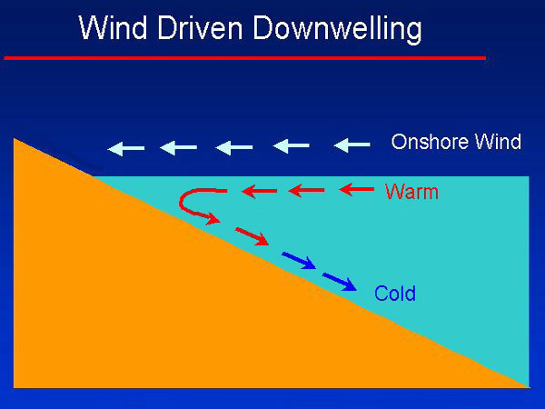
There are other avenues of research to pursue. Lew Gramer of NOAA and others published a letter in AGU’s Geophysical Research Letters in 2022, which finds that depending on how some storms approach the coast, they can produce a downwelling situation with nearshore shelf water. Downwelling sustains the warmer shelf waters, inhibits cooler, mixed water from taking over and inadvertently creates a better, longer lasting environment for strengthening, even in the face of other external hindrances, such as wind shear. They specifically looked at intensification cases from 2020 in the Gulf of Mexico, Sally and Hanna (as well as Eta in the Caribbean).
This idea seems to fly in the face of what was known about the Gulf of Mexico. Back in 2010, Ed Rappaport and co-authors from inside and outside NOAA determined that, in general, strong Gulf hurricanes tended to weaken as they neared landfall, while weaker hurricanes tended to intensify on approach. In other words, most Gulf hurricanes would, on average, trend toward the mean of a Category 3 level storm. As awful as they were, storms like Rita and Katrina in 2005 fit that paradigm, as have storms like Opal in 1995 and Ike in 2008. That has seemingly not been the case in recent years. Research published in March 2023 in the Journal of Climate found that there has been a substantial increase in Gulf of Mexico oceanic heat content. The surface warming trend is about double what has been seen in the global ocean since the 1970s.
Tying it together
When one examines all this research together, it does seem to say that the Gulf Coast is becoming or will eventually become increasingly vulnerable to worse and worse outcomes from hurricanes, be they stronger, wetter, or with worse surge. But there are significant nuances and multiple threads of thought that need further research.
Dr. Kim Wood is an associate professor at Mississippi State and focuses on tropical meteorology. When asked what people along the Gulf Coast should be thinking as they digest all this research, she says that the long-term situation is certainly a concern for this region, but it’s not as if a switch is going to flip. “Trends identified by research don’t mean every hurricane season will be worse than the previous one,” she told me via email. For long-term sustainability, Wood thinks that there have been strides in the Southeast U.S. to adapt to future changes in storms, but more needs to be done.
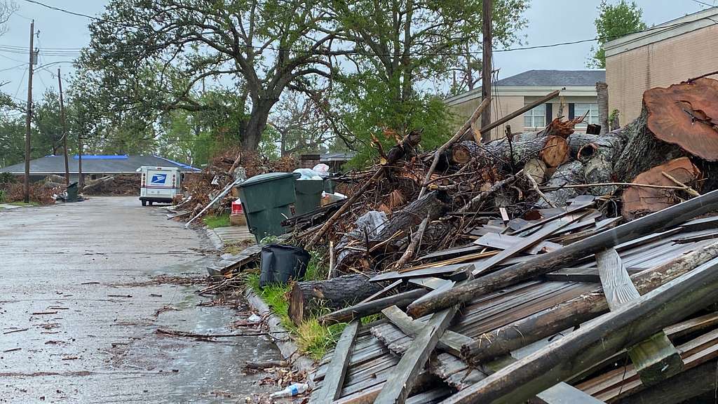
“More efforts—ideally efforts coordinated across city and state lines—are needed to ensure our communities are resilient to tropical cyclone hazards,” she said. Wood also has concerns about the research that shows storms slowing down their forward speed at landfall. While wind and storm surge are serious issues with respect to hurricanes, severe freshwater flooding, as seen in big storms like Harvey and comparatively smaller storms like 2019’s Tropical Storm Imelda or the unnamed Louisiana flood event in 2016, is critically important to monitor. Zick also echoed this concern. “We have stronger confidence that hurricanes are producing more rainfall and that these rains are falling at faster rates,” she says, noting that while wind is important, it’s fairly localized, and it is all the other hazards that impact many more people. Water is the biggest problem. This idea has also been emphasized by the new director of the National Hurricane Center, Michael Brennan.
There is a lot here to digest. But for her part, Wood says that while thinking about these things can be scary, preparing now can make it a little less scary—and easier. “Having a plan and thus knowing what you might do ahead of a hazardous weather event saves mental bandwidth for decision-making should that event occur.”
What’s next? Obviously more research will continue to be produced about these topics, and it is research that will be important for both the meteorology community and government decision-makers to understand. From a forecast perspective, we are slowly chipping away at intensity forecasting errors. Zick tells me that “hurricane forecasting models are getting better at predicting rapid intensification, and hurricane forecasters are able to forecast RI much more confidently in the last 5 years or so.”
Additionally, the fifth National Climate Assessment will be unveiled later this year, and for the Southeast, this is expected to discuss various weather and climate hazards and the compounding factors of population growth and land use change. If the research outlined above is any indicator, there will be a lot to discuss and plan for going forward on the Gulf Coast.
A special thanks to Dr. Kim Wood of Mississippi State, Dr. Stephanie Zick of Virginia Tech, Dr. Andy Hazelton of NOAA’s Hurricane Research Division, Dr. Kerry Emanuel of MIT, and Dr. Kieran Bhatia of Guy Carpenter for answering my questions and confirming my understanding of the research that exists.
Thank you for this excellent analysis.
Great Job Matt and thanks for the excellent job of explaining to us who are not meteorologists.
I really enjoy your work and thank you for Space City Weather.
I am somewhat disappointed that you are not more balanced in your analysis regarding the subject of “climate change”? You tend to lay all things occurring bad at the altar.
There are equally strong scientific analyses that point to the whole concept being untrue. My own belief is that there is perhaps a middle ground that says yes we should exercise good stewardship but to say the world will end unless we spend $1 trillion plus is ludicrous.
Please cite the other “equally strong scientific analysis” for us to consider.
Fred,
I too would like to look at the “equally strong scientific analyses.”
I’m disappointed there are still people out there who refuse to acknowledge the science behind the very balanced analysis presented in this article.
I’m not going to get into a debate on this, as there is actually not equally strong scientific analysis pointing to the concept as being “untrue.” Climate change is real and happening. We can argue nuance of exactly how bad or where it will be felt worst or even the very small minority of places that may benefit. But saying the concept is untrue is a non-starter. The point of this post was to lay out what the peer-reviewed research actually says from a variety of sources. There’s no agenda and very, very little editorializing. It’s a 100% objective review of what the research tells us right now. Unfortunately, it’s not great news. That’s simply the reality. But, as I note several times in the piece, there are some conflicts and there is a lot to be done to better understand things. We still don’t know everything. But as of today, we need to plan for a future on the Gulf Coast that is going to be a bit challenging. And that’s just the reality of it all.
Excellent analysis. I really enjoyed this deep dive into the research. With scientific research there’s always a challenge of trying to communicate the findings in layman’s terms. Many journalists make the attempt to translate the findings for their readers, but they are typically limited by a need to be brief and they don’t always do a good job of translating the nuance of the results. I think you nailed it, Matt, and I look forward to more of your writings.
Thank you! That’s the benefit of our format. We are trying to put it all in layperson terms and we fortunately have the understanding of both communication and the science to translate between the two. Hopefully we’ll do more of this going forward.