One-sentence summary
Superfog, or near-zero visibility caused by the combination of fog and wildfire smoke has wreaked havoc on Louisiana recently, so we take a deep dive into how the term came about and why this is such a problem there this year.
Superfog: A super serious problem in Louisiana
If you’ve been paying attention to the news lately, particularly as it relates to weather, you’ve likely heard about “superfog” leading to a couple deadly traffic incidents in Louisiana. If you missed that news, here are a couple articles to catch you up.
The first incident was a major pile up on I-55 a couple weeks ago that killed at least 7 and injured over 60 people.
More recently, another superfog event led to an 11-car pileup on I-10 east of New Orleans that killed one and injured eight.
So what’s the difference between regular fog and superfog? And why is it so problematic?
What is superfog?
The technical definition of “superfog” is a combination of smoke and water vapor that produces zero visibility over roadways. What sets it apart from regular dense fog? The smoke. “Water vapor that produces zero visibility” is usually just plain old fog. When you combine fog and smoke and get zero visibility, you get “superfog.”
You may say to yourself, “Self, I thought smoke and fog was known as ‘smog?'” You are correct. The difference is that smog typically results from manmade pollutants, whereas superfog is produced from “smoldering organic material” and has extremely low visibility.
Is superfog some new clickbait term?
“Superfog” is not clickbait, a new term, nor is it a new problem. In fact, the South has been a notorious hot spot for superfog incidents for many, many years. This front page headline from the May 8, 2000 Biloxi Sun Herald reported on a similar incident on I-10 due to smoke from a prescribed burn mixing with fog.
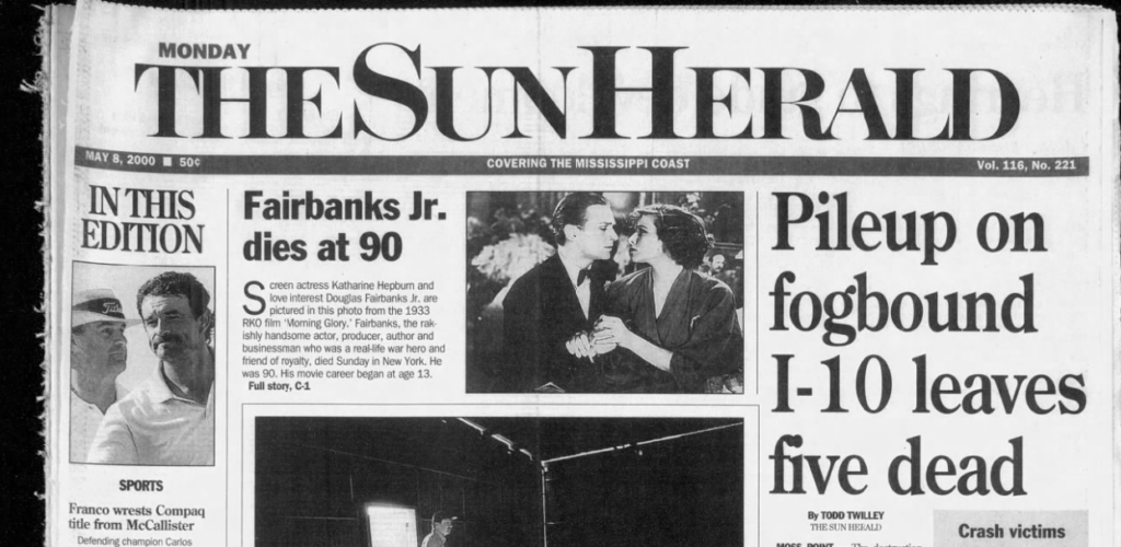
In that article a Mississippi Highway Patrol officer was even quoted as saying “We’ve had two or three multi-car accidents because of smoke and fog mix.” A 1989 study by Hugh Mobley found that from 1979 through 1988, visibility reduction caused by smoke or a combination of smoke and fog caused 28 fatalities, over 60 serious injuries, numerous minor injuries, and litigation expenses into the millions. That study, as cited in a more recent 2003 USDA Forest Service paper by Gary L. Achtemeier started to quantify the impacts of what had (presumably) yet to be coined as “superfog.”
The origin of the term “superfog” itself seems to come from Achtemeier. As best as I can tell, he first formally coined the term in a 2001 abstract that I believe was intended for an American Meteorological Society meeting. So, I think Achtemeier is the Father of the term Superfog, and Hugh Mobley may be the originator of understanding its impact. Whatever the case, in this 2003 USDA Forest Service paper by Achtemeier, he does a good job explaining why the South is a hotbed for superfog events. And it appears that recent issues in Louisiana broadly fit the mold.
In his paper, Achtemeier notes a high number of prescribed burns that are done in the South. To my knowledge, the recent fires in Louisiana were not prescribed burns. But his other points stand. It’s a relatively humid period in the cool season right now, making fog more likely on the Gulf Coast. And this most recent marsh fire occurred very much at the wildland/urban interface in New Orleans East. So you have a number of people traveling in a smokey area, with conditions ripe for fog. From the paper, you can see imagery that shows the difference and uniqueness of superfog. Unlike regular dense fog with, say, visibility under a quarter-mile, superfog is literally zero visibility, often 10 to 20 feet or less. It’s easy to understand why that would lead to such severe outcomes on roadways. Anyway, if you want to better understand some of the initial hypothesis behind specific superfog development, that paper makes for an interesting read.
Why all of a sudden in Louisiana?
Louisiana is currently experiencing one of their worst droughts in recent memory.
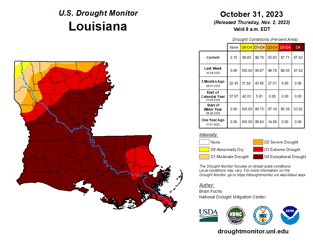
Almost 70 percent of the state is covered in level 4 of 4 (exceptional) drought. It’s bad. And marsh fires have been happening for weeks from Cameron Parish in the southwest corner of the state east into the New Orleans area. Now, as fog season begins to ramp up on the Gulf Coast, we are seeing additional consequences of these fires.
If you want to look more specifically at Tuesday’s incident, you can at least pick out the fog easily on modeling. A forecast sounding, or vertical profile of the atmosphere from the NAM model averaged for the area just east of New Orleans at 7 AM on Tuesday shows what we call an inversion in the atmosphere about 500 to 1,000 feet off the ground.
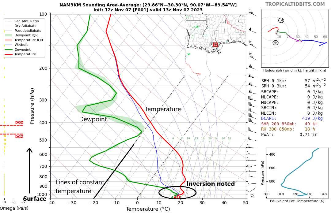
What is an inversion? Normally, as you go up in altitude temperatures decrease. Inversions are places in the atmosphere where temperatures actually rise as you go up in altitude. In other words, you see warming in a slice of the atmosphere before temperatures begin to cool again. Inversions tend to suppress thunderstorms. During the storm season, we refer to these as “caps” or “capping” in the atmosphere. That inversion acts as a barrier to cloud-top growth, or vertical development. It also tends to act as a “lid” on the atmosphere, trapping any gunk underneath it near the surface. This can cause smog in cities and fog in cities and rural locations as well. In most cases, inversions tend to break as surface temperatures warm up during the day. But long-duration inversion events over days or worse with fog and severe smog problems will sometimes occur in Utah’s Wasatch Front in the winter months. There is also Tule fog in California’s Central Valley, which is common in the cool season.
In this case, a sharp, shallow inversion in a humid environment was able to lead to fog development outside New Orleans on Tuesday. The fog in the area of the fire was able to transition to a localized superfog event just east of New Orleans.
A cool front should push through most of Louisiana by early next week hopefully providing a respite from fog. But it does appear that another substantial period of humidity and fog risk may be possible later next week. The NWS in New Orleans has been all over this for awhile now and remains the best source for local information in that area.
Masterful information, Matt 😊
You’re a great teacher – always helping us non-meteorologicals understand the weird/strange stuff we’re experiencing.
You definitely lower weather angst. Love that so much! 💞
Always learning from the Eyewall 🎯
Ty 😉
🌬 🍂 🍂 🌧 🦉 🌧 🍂 🍂
Never knew I would learn so much about fog.
Thanks Matt
In the past, Sugar Cane Fields in South Louisiana were set afire during the Fall/Winter Seasons to remove the green leaf like material to aid in harvesting. Homes & cars all along Costal Regions would be covered with ashes. I’m sure Louisiana experienced many days of Superfogs historically.
Matt, thanks for breaking down such a complex weather phenomenon. I just wish I would stop reading “fog” as “frog”. 😀
Always an education in meterology…THANKS!!!!!!!!!!!
Fascinating stuff, thanks Matt.
What sets a weather superblog apart from a regular weather blog? Definitely the presence of Matt and Eric!
This is why The Eyewall & Space City Weather are so special. Unique. Routinely go above & beyond as meteorologists. Nobody does weather like you guys! Appreciate you.
I’ve driven through Louisiana fog around 3am in the morning and that is quite a terrifying experience as the lack of cars mean you have no idea how far you actually can see. Are there any rule of thumbs for these events. It seems early morning and first few hours after daylight is usually the worst time for fog as the day time heating helps burn it off, does this generally hold for super fog events, too? Sadly, I have to drive through Louisiana along I-10/12 in in 10 days (next weekend), likely late morning/early afternoon timeframe.
Thanks. We were discussing the smog/superfog distinctions at dinner. I can win the ongoing argument with your piece! It must be very scary to find yourself in a superfog situation.
Thanks for the info Matt – always learn something here. And I’ll definitely check the NOLA weather service before my next trip down I-10.
Excellent research article.