One-sentence summary
Today’s post talks about the potential for a late season tropical system in the Caribbean this week, as well as a detailed look at polar opposite weather that’s causing trouble in Alaska lately.
Tropical update: Caribbean mischief may present itself this week
We’ve got ourselves a late season system to possibly monitor in the southwest Caribbean later this week.
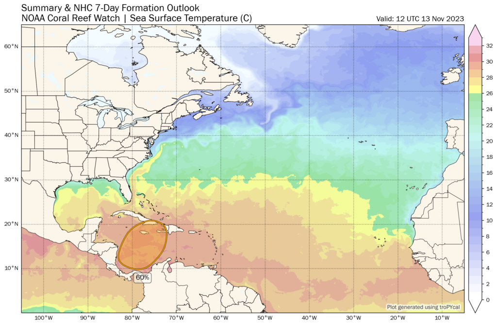
Model guidance is pretty persistent in developing low pressure off the coast of Nicaragua or Costa Rica around Wednesday or Thursday. It would quickly move northeast or north-northeast toward Jamaica, eastern Cuba, or Hispaniola from there, before accelerating out into the open Atlantic, perhaps impacting Bermuda on the way out this weekend. This will all occur quickly.

As is often the case this time of year, the GFS model is much more aggressive with this system than the European model. The GFS has the equivalent of a strong tropical storm or low-end hurricane racing northeast of Jamaica on Saturday, whereas the Euro is a bit slower and notably weaker. The Euro has had a slightly better track record in the Caribbean, but it’s still a good idea for eastern Cuba, Jamaica, Haiti, and the Dominican Republic to monitor this potential system in the coming 2 to 3 days. From there, the Bahamas, Turks & Caicos, and Bermuda should also keep tabs on things. Whatever happens will happen fast, as this thing is going to be hauling north-northeast, tracking from the deep southwest Caribbean on Wednesday or Thursday to past Bermuda by Sunday or Monday.
U.S. Weather this week: Stormy Gulf, wet West Coast
A storm system on the Gulf Coast over the next couple days will bring some moderate to heavy precipitation between Texas and Florida, with anywhere from 2 to 5 inches likely. The highest totals are likely near Mobile, AL and Pensacola, FL. Flooding isn’t expected to be a huge concern, as the entire region is in pretty serious drought, and if anything, this will be a mostly beneficial rainfall.
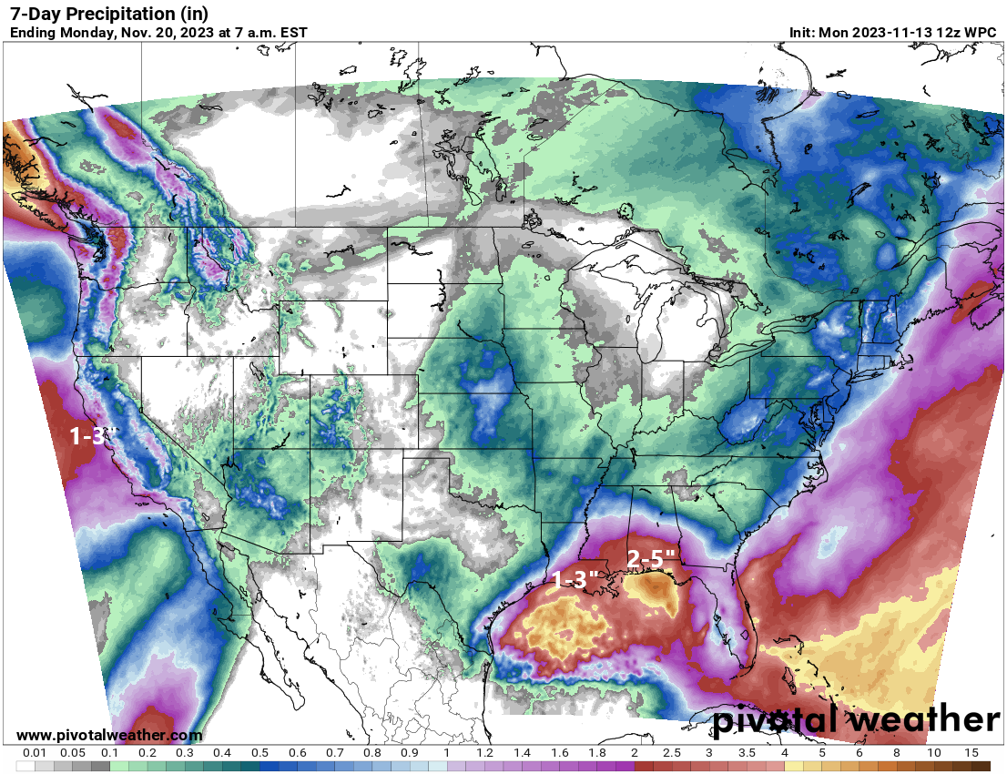
The West will see a few surges of moisture this week thanks to a storm sitting offshore of California. This is expected to bring moderate to locally heavy rain to coastal California and some snow in the Sierra.
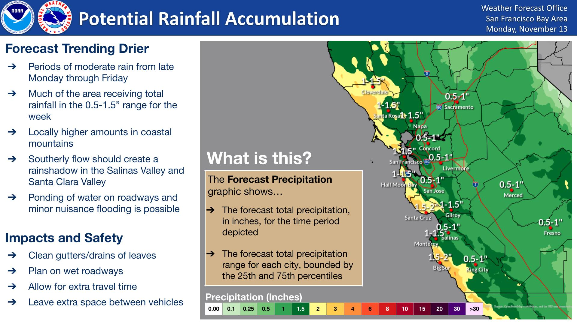
Overall, this should be more of a periodic ramp up/ramp down type precipitation event for California, but the rain (and snow) will add up over time. About 1 to 3 inches of rain is possible on the coast, including both San Francisco and LA, with locally higher amounts in the mountains and perhaps a little less in San Diego. Flooding isn’t a major concern at this point, particularly as the forecast has trended a little less excited about things.
Flaked Alaska: Heavy snow causes familiar problems in Anchorage
We don’t often talk about Alaska for weather unless it’s due to the pattern up there impacting the pattern for the weather across the U.S. But it’s worth talking about what’s happened in parts of Alaska to start November.
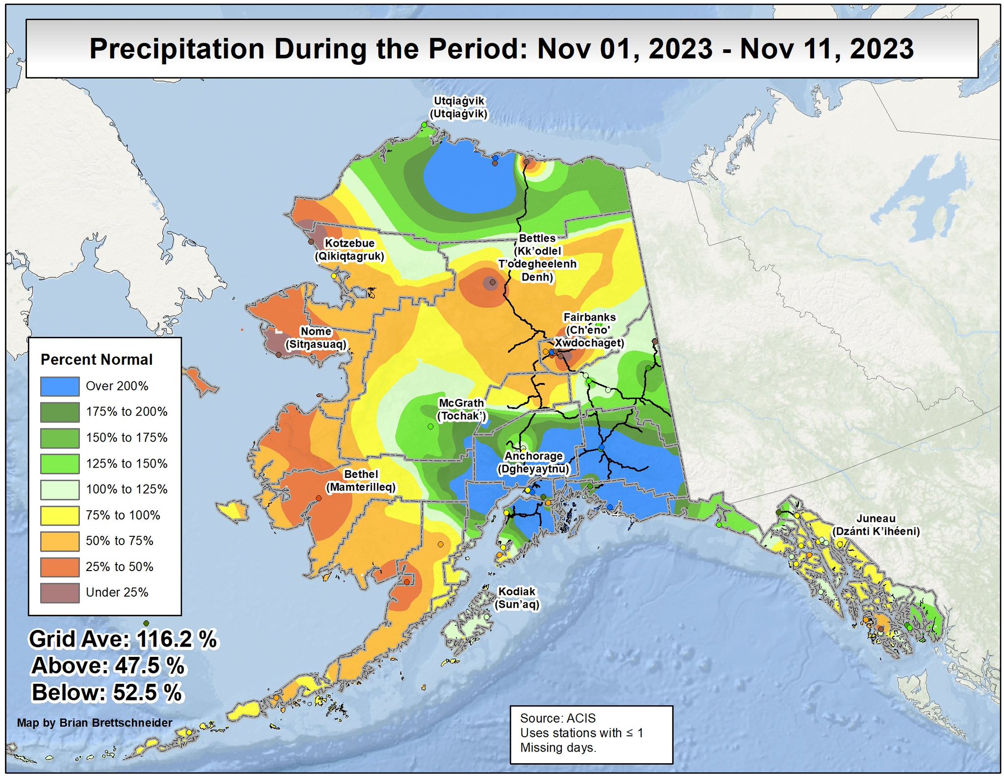
Anchorage, the largest city in Alaska, with a population near 300,000 has received nearly 30 inches of snow this month so far, most of it courtesy of an atmospheric river event last week. This is the snowiest start to November on record in Anchorage. I reached out to the authority on all things Alaska weather, Brian Brettschneider, and I asked him to put into context how this sort of big time snow fits the typical climatology for Anchorage.
First, he tells me that the median snow depth for Anchorage around this time of year is about an inch or two. The snow depth there is around 2 feet, which only happens in maybe half of all winters at all there. “This snow will not fully melt out until April,” he says.
On top of that, this was a wet snow for Anchorage. What do we mean when we say “wet snow?” A number of factors play into what we call the “snow ratio,” or how much snow you would melt to get 1 inch of water. In general, colder and drier air masses produce higher snow ratios. It takes more snow to get that 1 inch of liquid. You see this a lot with lake effect snow. One inch of liquid may produce anywhere from 20 to 30 inches of dry, fluffy snow.
Warmer, more humid air masses tend to produce lower snow ratios, or situations where it does not take as much snow to produce an inch of liquid. A general rule of thumb, particularly on the East Coast, is that 10 inches of snow usually melts down to 1 inch of liquid. So the ratio is 10:1 (ten to one). In Anchorage, a colder and typically drier place, Brettschneider says that the average ratio is 17:1 typically. With this recent event, the snow ratio was 11:1. I wouldn’t call that “cement,” but that’s a very wet snow for Anchorage. Wet snow tends to be harder to move and clear, it can bring down trees and power lines, and it also causes significant issues on roadways as it will produce slush that can freeze into solid ice. This is one problem in Anchorage right now.
And it’s not a new problem either. Brettschneider said that it’s important to understand the current context of the situation in Anchorage. “Three rapid succession storms last December caused a month-long road-pocalypse around town. The state/city made it a priority to not let that happen again – yet here we are.”
Last December, Alaska Public Media asked “Should snow in Anchorage be this disruptive?” In a follow up article last month, APM reported that Anchorage said it was prepared should a storm like last December’s happen again. Anchorage mayor Dave Bronson said at his October news conference, “We are ready.”
The residents of Anchorage can decide if that’s the case. The second major multi-day snowstorm in Anchorage in less than a year is surely impressive. It’s also worth noting that despite the snow, it has not been cold in Anchorage, at least not compared to normal. “So far this month, the first 11 days are all warmer than normal in Anchorage – much warmer than normal,” per Brettschneider. It typically takes someone milder weather to produce this kind of snow in Alaska, as warmer air can hold more moisture.
On a serious note, the AP reports that four unhoused people died during the winter storm in Anchorage last week.
More snow is coming to Alaska today, including Anchorage.

As much as another half-foot or even a bit more of snow is possible in the Anchorage area today, with higher amounts in the Chugach Mountains east of the city. More snow is possible later this week.
That’s very interesting about the snow up there – easy to think it’s all the same stuff till you break down the physics into something more experiential.
The imbalanced weather pendulum swings further and further away…
The mammoth died out, partly bc of conditions that were wet and cold. They literally froze to death. They had all that hair (not fur) that evolved for cold & dry conditions, but became detrimental when it became wetter.
So, wet snow up there doesn’t sound good. Hope it reverts back.