One-sentence summary
Two separate systems are on the board, with one (non-tropical system) bringing heavy rain to Florida tomorrow and then heading off to the north, while another disturbance in the Caribbean has a chance to form before racing past Jamaica, Cuba, and Hispaniola later this week or weekend.
Florida flooding: Metro South Florida at risk for considerable flash flooding on Wednesday
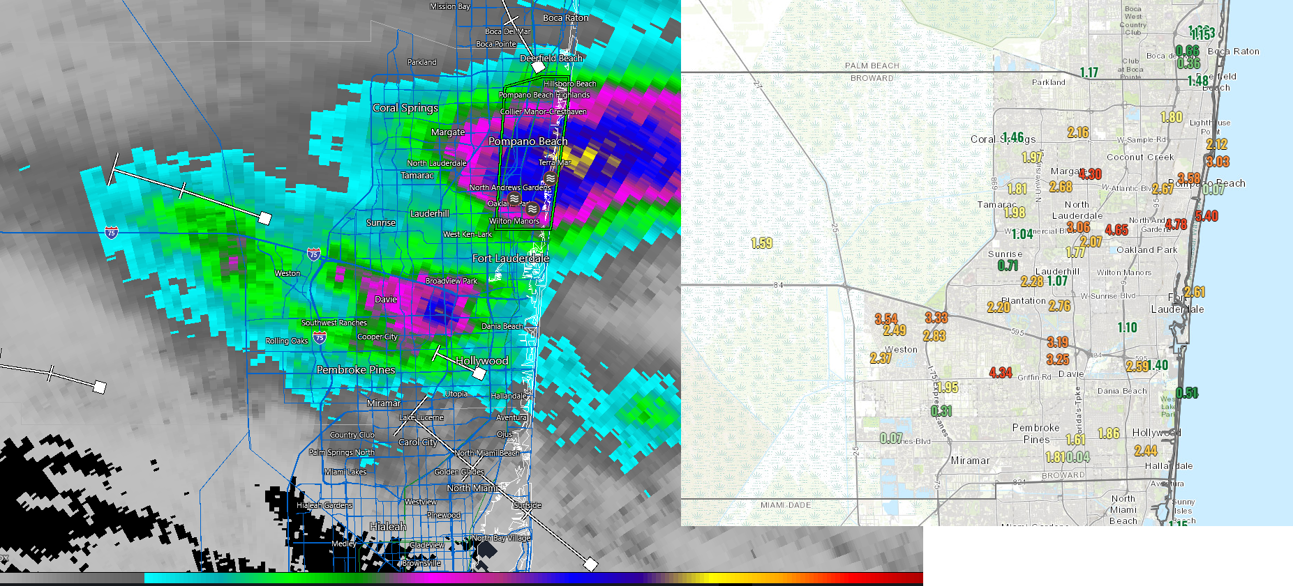
Just a quick update this evening on what’s happening in the world of weather, and we’ll start in Florida. Areas just north of Miami have seen some heavy rainfall today, with two bullseyes of 4 inches or more, the first near Davie and the other around Pompano Beach, where over 5 inches has fallen.
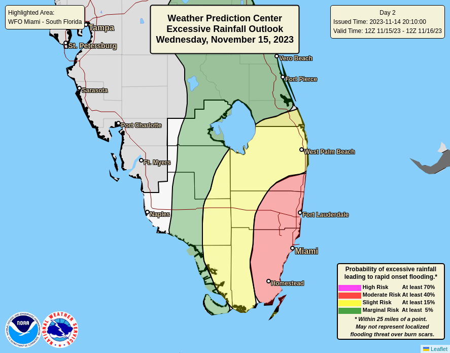
As showers diminish tonight, a quiet period will unfold before another, more widespread round of rain and storms tomorrow. This one will be capable of significant rain totals in excess of 4 to 6 inches to as much as 8 inches or even more tomorrow for parts of coastal, urban South Florida. Because of this, the NWS Weather Prediction Center has Miami-Dade, Broward, and portions of Palm Beach County under a moderate risk (level 3 of 4) for excessive rainfall and flooding risk on Wednesday.
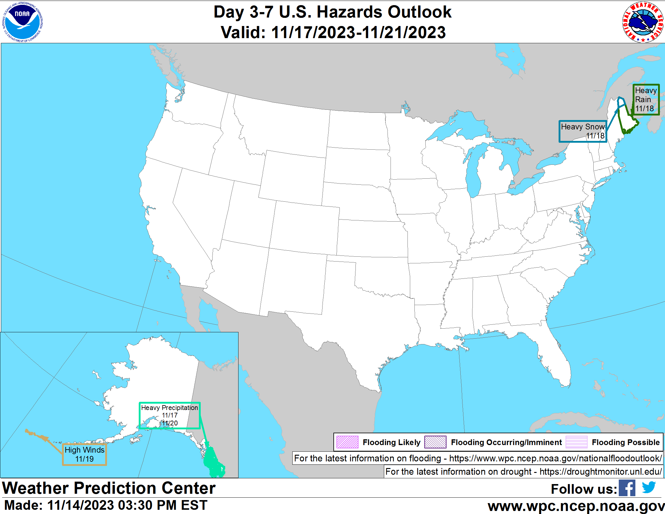
Intriguingly (and somewhat confusingly), all of this may congeal into an area of low pressure off Florida’s east coast that has a low (albeit not zero) chance of developing into a tropical system as it races north and east. This is *not* the same system we’re watching in the Caribbean, but this one may produce a nor’easter type impact in eastern New England or Atlantic Canada by the weekend, including a chance of heavy snow on the back side of the storm for portions of Quebec, New Brunswick, or northern Maine.
Tropical Update: Caribbean development remains possible later this week
Meanwhile, we continue to see at least the chance that a late season tropical system will form later this week in the Caribbean. The good news is that both the GFS and European model have tended to reduce the odds of anything significant developing.
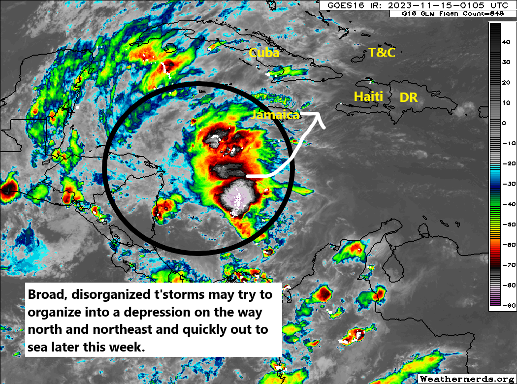
So what was already a low chance of a significant storm is now quite low. Certainly heavy rain is possible, if not likely across the Caribbean, but getting this thing to depression status or even TS Vince, will take some effort. Can it get there? Sure, but I’m not sure it’s the most likely outcome. Regardless, interests in the central and western Caribbean should continue to monitor this thing until it passes.
Hello The Eyewall – As a S.E. Florida resident, I thank you for what you do!
I’m in the middle of this short-term (today and lesser-so tomorrow) serious rain mess in Broward county, Florida. It was a minor problem for me with flooding and traffic jams. No big problems though; I’m used to it – I was born and raised here and I know how to pick a place to live that is not flood-prone.
I’m happy to see people from the North-East starting to flock-in to S.E. Florida running away from the cold temperatures (and increasing crime and taxes) – I welcome you – really! But while you visit those of us who live here year-’round, please try to use some common-sense when driving in inclement weather – especially when it is raining buckets.
The moment I spot a NY or NJ license plate, I triple my following distance, turn down the radio to limit distractions, and prepare for something stupid-crazy to happen on the road at any moment. The only way to get out of that situation is to carefully navigate away from the worrysome vehicle – and its driver. (That’s probably good advice for anyone – anytime.)
It’s really about the visitors we get here in S.E. Florida from the N.E. U.S. States. In my opinion there is an exception however: We get lots of Snow-Birds visiting us from the Canadian Provence of Quebec, mostly from the city of Montreal. Typically I observe few problems with the driving proficiency of a car with a Montreal tag – there’s probably a good reason: If you have ever lived in and driven in Montreal during the winter (I have); You automatically learn defensive-driving – if-not, you’re dead.