One-sentence summary
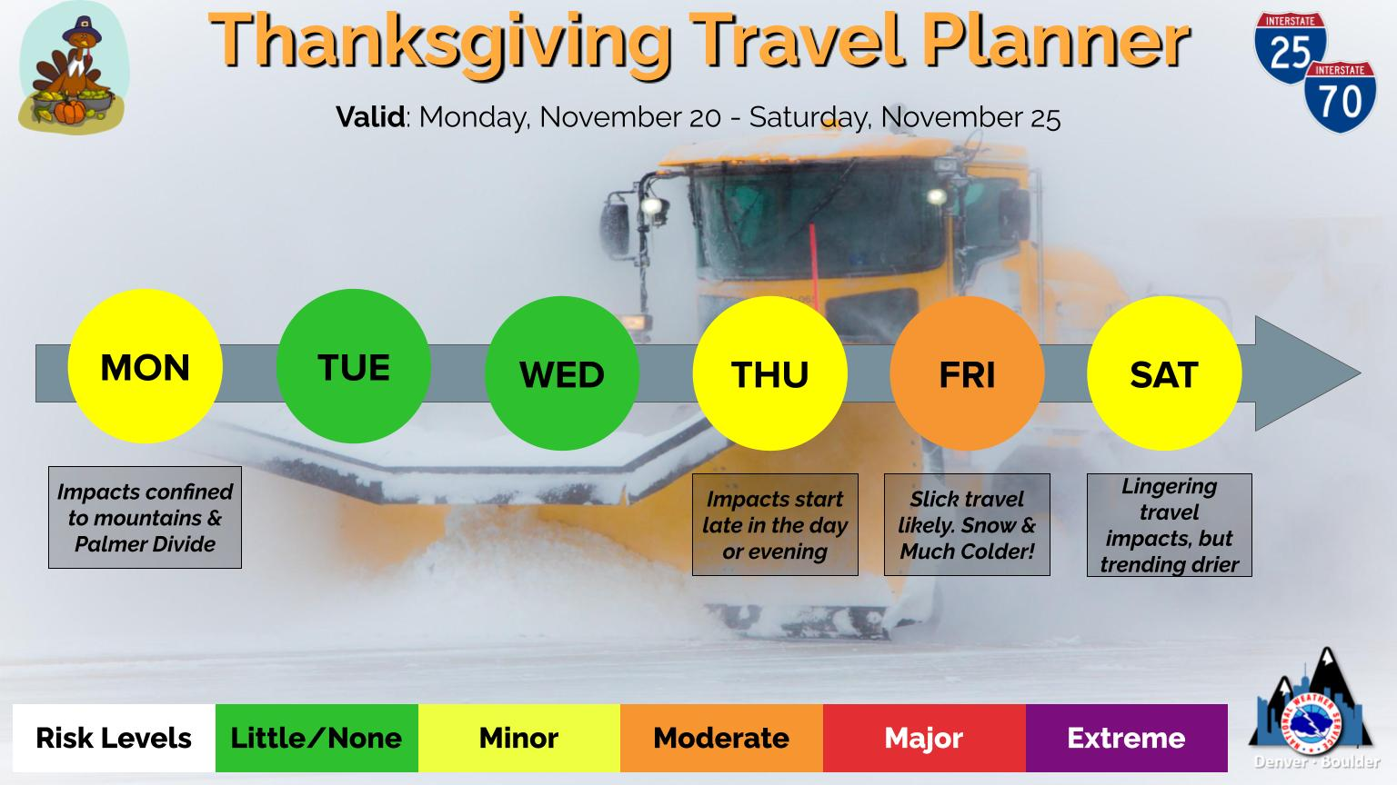
Thanksgiving week travel looks a little sloppy in spots at times, but we can hopefully avoid any massive travel disruptions this year, at least due to weather.
Thanksgiving week outlook
It’s never easy, right? Travel anytime of year is a crapshoot to be sure, but of course during probably the busiest travel week of the year, we punctuate our mostly benign autumn with a fairly big storm. Different days this week will have different hazards in different parts of the country. As of now, it doesn’t look like we’ll see anything severely disruptive, but there are a couple things to point out.
Today: Severe weather risk in the Deep South
The main story for the Monday phase of this storm will be severe weather risk for the Southern US. Louisiana and Mississippi seem to be the prime spots at risk today for strong winds, hail, and possible tornadoes.

The tornado threat is not a guarantee, but if storms can maintain themselves individually in Louisiana or extreme eastern Texas (before “lining out” into bands of t’storms), a strong tornado or two will be possible. Either way, reports of hail and strong, damaging winds are possible, if not likely with storms today that should get going through the afternoon hours. The severe risk will push into Mississippi later this afternoon and evening and into Alabama and parts of the Florida Panhandle perhaps by the overnight hours, with a continued severe risk. Some adjustment of the above risk is possible before the end of the day today. If you’re traveling in this region today or tonight, please ensure you have the ability to receive weather warnings.
Tomorrow: Rain & wind in the Northeast and Midwest
The storm itself will track from about the Red River Valley into southern Michigan or near Lake Erie between today and tomorrow. This means that on Tuesday, we’ll begin to see widespread rain, thunderstorms, and gusty winds in the Eastern U.S. Gusty winds will likely delay some flights to and from places like Chicago, Detroit, Cleveland, or Pittsburgh.
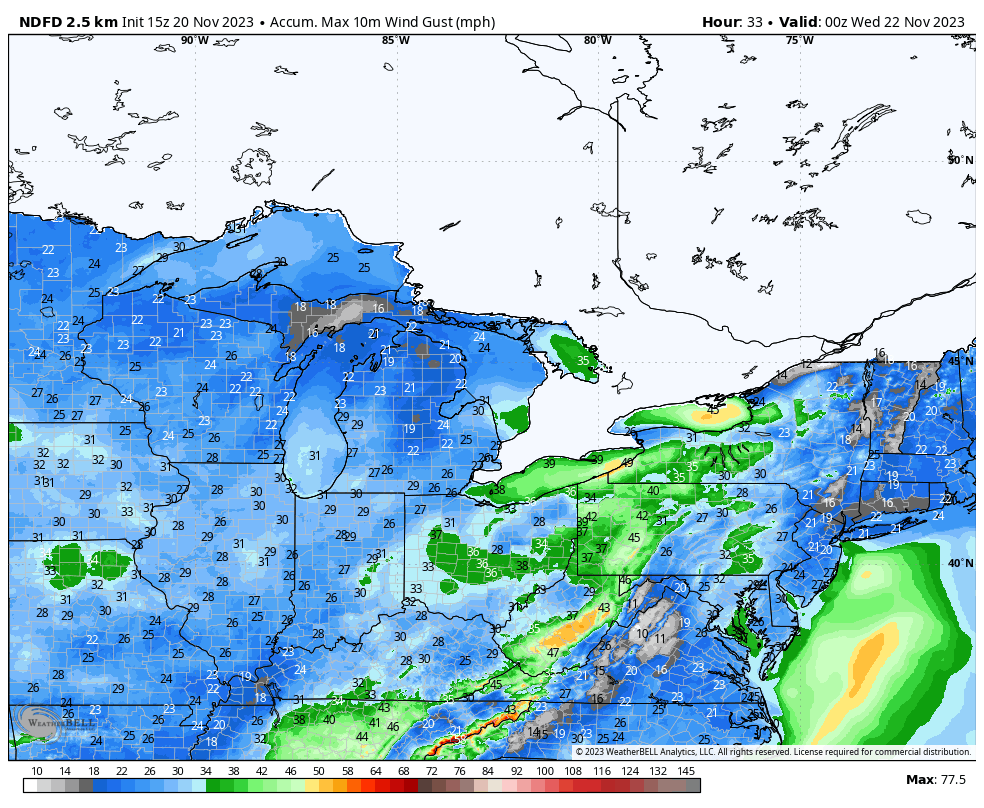
Rain may begin as a wintry mix for parts of the interior Northeast as well. Overall, this won’t be a massive storm up that way, but it will be enough to cause disruption.
The primary severe weather risk tomorrow will be with the continuation of storms overnight into the morning hours moving across Alabama and the Florida Panhandle.
Wednesday: Improving, except in the Northeast
Boston and New York may still see some gusty winds on the backside of the storm Wednesday as it exits in the morning.
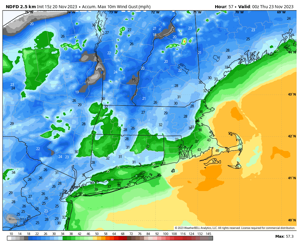
Gradually improving weather is expected during the PM hours, but some of those wind gusts in the front half of the day may cause some travel headaches.
Elsewhere, there’s at least a subtle severe risk in eastern North Carolina before the front exits, but that’s not expected to be a big deal.
Thanksgiving Day: Showery Gulf Coast, snowy Wyoming?
Travel overall looks fine on Thanksgiving Day if you’ll be hitting the road. The two exceptions to this are on the Texas Gulf Coast and in Wyoming.
For Texas, showers are possible between about Laredo and Matagorda Bay south through Corpus Christi and the Valley. This won’t disrupt travel much, but it could put a slight damper on any outdoor Thanksgiving plans.
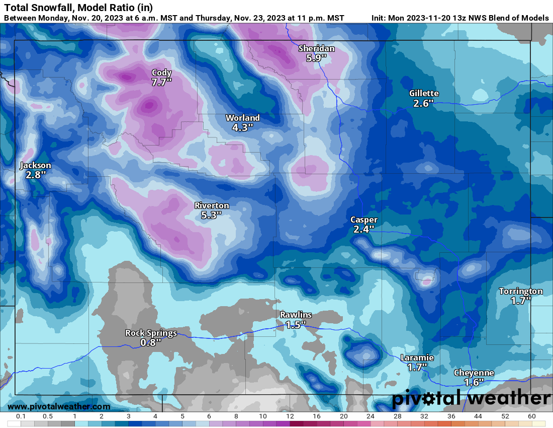
The situation in Wyoming and southern Montana is a little trickier, as is always the case with snow forecasting more than a day or two out. A storm seems likely to deliver some wintry weather to the region on Thanksgiving Day, but exact amounts are TBD. Whatever specifically happens, if your travels take you to Yellowstone or portions of northern Wyoming and southern Montana, you will want to be prepared for some travel difficulties.
Friday: Storms in the Southeast, snow into Colorado?
The aforementioned winter storm in Wyoming on Thursday will probably slide into Colorado on Friday bringing a chance of winter weather there that could cause some travel issues.
Travel impacts are currently expected to be on the moderate side across Colorado, so if you are traveling from Denver to go skiing or visit the mountains on Black Friday, you will want to be ready to deal with some weather.
Elsewhere, the showery system in Texas on Thursday will move across the Gulf Friday, bringing a chance of showers and storms to the Southeast, particularly Florida. The rest of the country looks pretty good.
This weekend: Some uncertainty
The weekend looks ok at this point, with the Colorado system diving into the southern Plains bringing a chance of showers. Additional showers are possible on the East Coast later Saturday and Sunday, but as of now nothing looks too serious. We’ll keep tabs on things.
Thanks! Is that map product from SPCC available for the 2 day Convective outlook? Trying to make out the extent of the “slight” risk area into NW Florida Panhandle for Tuesday.
Hi Elizabeth! Here’s the link I pull these from: https://www.spc.noaa.gov/public/state/images/ Specifically day 2 SPC for FL: https://www.spc.noaa.gov/public/state/images/FL_swody2.png
Thanks so much! That is much clearer.