In brief: Today’s post looks at hurricane season now that we’re 3 weeks out. What does a strong or super El Niño actually mean in terms of numbers compared to history? And what, if anything, is different about this season?
A quick note: Part one of our season in review from 2025 was posted a couple weeks ago. Part two should be posted this Wednesday.
We’re exactly 3 weeks from the start of hurricane season. The news has been pumping this upcoming El Niño event, which may actually be worth the hype when all is said and done. It does look quite significant, and that will have global impacts. And we know generally that El Niño tilts the odds in favor of a less active hurricane season than usual. A strong El Niño on the order of a 1982-83 or 1997-98 seems plausible.
If we break down Atlantic hurricane seasons back to 1980 and focus on just strong-er El Niño events, not even just the strongest ones, here’s what you get. And consider these approximate values, not official ones; definitions of when El Niño or La Niña start can vary based on metric used, and no single one is perfect. The intent here is to show you the difference between stronger El Niños, all El Niños and La Niñas when compared to average seasons.
| Average of Seasons | Strong-er El Niño | All El Niño | All La Niña | Average Season |
| Named Storms | 7.5 | 9.5 | 15.9 | 14.4 |
| Hurricanes | 3.2 | 3.8 | 8.1 | 7.2 |
| Major Hurricanes | 0.8 | 1.5 | 3.4 | 3.2 |
| Accumulated Cyclone Energy (ACE) | 39.6 | 56.4 | 127.1 | 123 |
El Niño events such as the one we expect will emerge in the next few months historically, if not dramatically depress hurricane seasons. Even when compared to all El Niño events, the stronger ones are even more muted.
So, it’s safe to say that you should shrug this hurricane season off, right? Well, maybe not entirely.
Yes, this should probably be a less active hurricane season, and in all likelihood, it will be even less active than the last two seasons which were odd in and of themselves. But there’s one interesting, rather big difference between years going into stronger El Niño summers and this one. And that is global water temperatures.
Historically, we’ve had a slightly warmer than normal Gulf of Mexico and southwest Atlantic and a fairly widespread below average Atlantic main development region. This year? Not quite that cool.
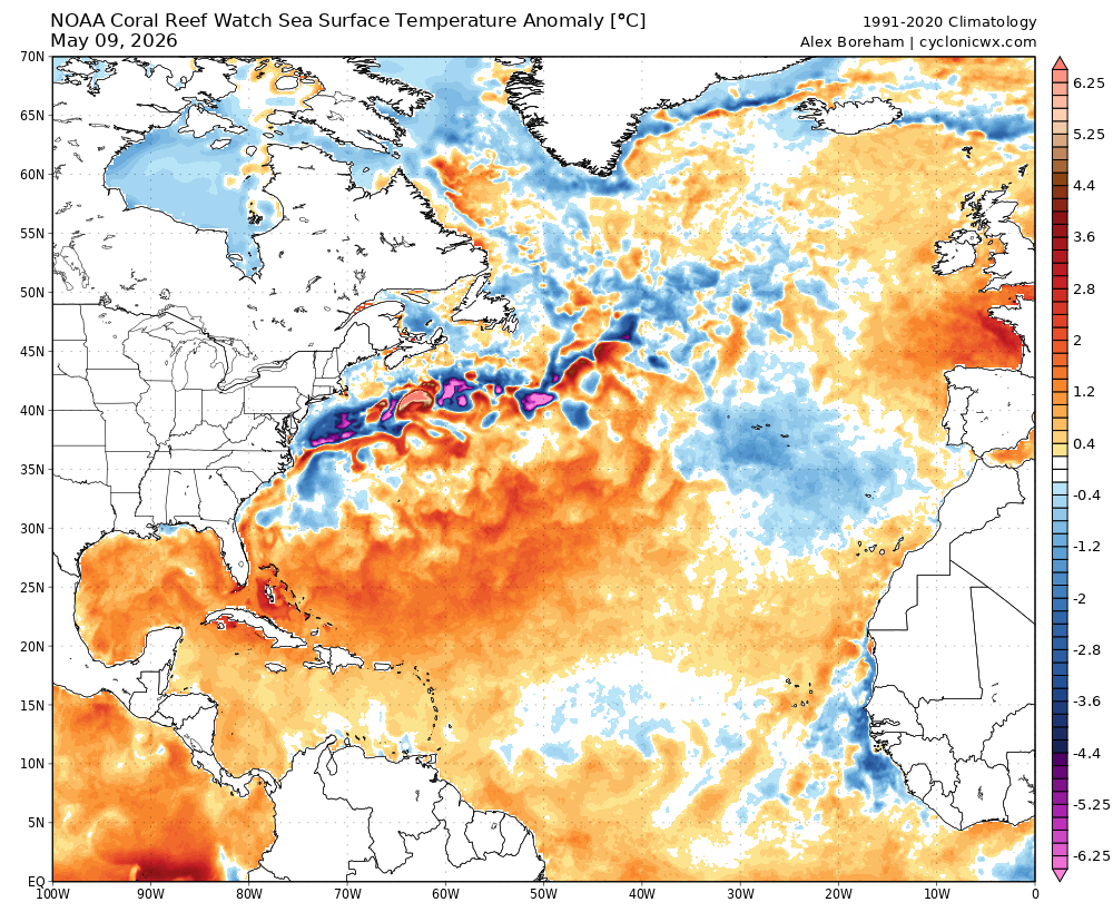
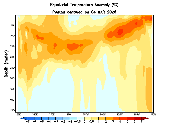
We still see the warm Gulf and very warm Bahamas. The MDR? On par with historical pre-Niño summers. But the Atlantic subtropics are much warmer than normal. But it’s less about the shape and more about the amplitude, I think. According to Dr. Kim Wood’s charts from the University of Arizona, the Gulf? Near record levels for this time of year. The MDR? Near average. Subtropics? Near records. (As an aside, the eastern North Pacific is going to be primed for what could be a wild hurricane season between Mexico and Hawaii)
What does this mean? Well, sea surface temperatures alone will not get you massive amounts of storms. The last 2 years have more than proven that. However, what they can do is boost the odds a little higher than usual. So if a typical stronger El Niño summer would usually see an 8/3/1 slash line for storms, hurricanes, and majors, maybe a summer like this has a storm or two of upside. It’s like performance enhancing drugs in baseball. As a player, you should hit a certain number of home runs based on your strength and skills. But if you add enhancers, well, you’ve just bumped up your odds of hitting the ball a little farther and a little harder now when you do make contact. Warm SSTs can do that for tropical systems: When the conditions come together, maybe you can snag an extra named storm or a major hurricane now.
So that’s why I think this hurricane season will still more than likely be less active than usual, but maybe with a touch more upside risk to the storm numbers than in a typical stronger El Niño.
Regardless, if the only storm we get all season is a category 4 that hits a populated part of the coast, that’s a bad season, and it’s why if you live along the coast you should prepare for this season as you would any other season. Hope for the best, but prepare just in case.