One-sentence summary
Scroll to the bottom for a couple notes on current weather, but in today’s post, I want to try to make some sense of what just happened in Mexico this week.
Otis’s catastrophic rapid intensification: What happened?
In general, I think Eric did a good job yesterday sort of conveying the general shock many of us in the meteorology community had with regard to Hurricane Otis. The word “unprecedented” gets tossed around a little too fast and loose these days, but truly, this was without any real precedent in Acapulco. And it was with only slight precedent anywhere in terms of how quickly it intensified.
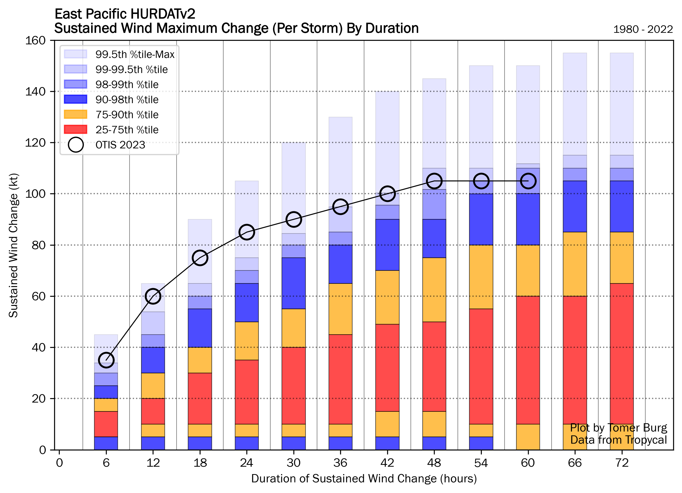
Otis was the textbook definition of rapid intensification (RI), going from a 50 mph tropical storm on Monday evening to a 165 mph category 5 hurricane last night. Look at the change in Otis between Sunday evening and Tuesday evening, 48 hours apart. You can see the intensification chart to the right of the satellite loop. Through about mid-morning on Tuesday, everything was going basically as you’d expect for a modest hurricane with Otis. It may have been tracking toward a category 2 type landfall, or even a category 3 type landfall in a worst case, if you assumed the general rules of RI in this region.
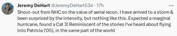
Much like an onion, there are layers to this story that are important. First, take it from one of the more seasoned hurricane hunters, this was not what they expected when they flew their mission on Tuesday.
And this was before Otis had peaked. The typical satellite-derived intensity values often used to “proxy” intensity of storms that are far away from reconnaissance flights failed in this case to grasp how intense Otis was. In other words, Otis intensified so quickly that it basically outran the ability to measure how intense it actually was.
Here was the raw model output for Otis from Tuesday morning. This is what general weather forecasters would use to assess what the models assume will happen with a storm’s wind forecast. The dashed line is what actually occurred.
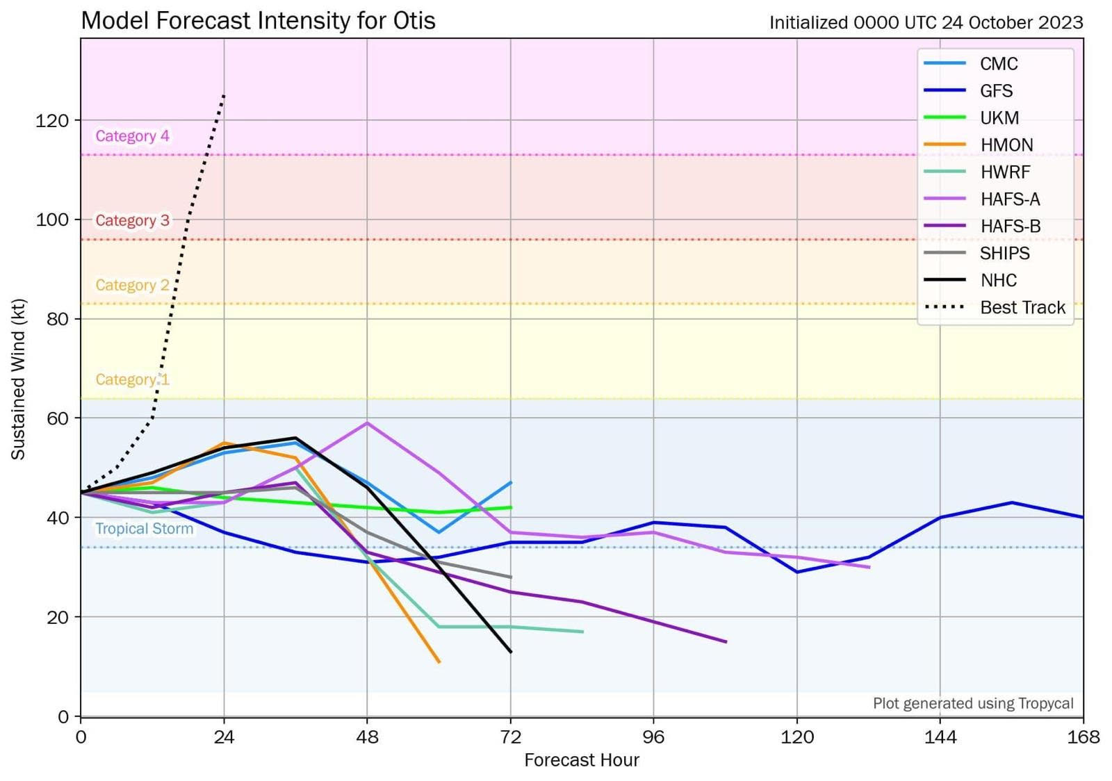
None of the best, most reliable tropical modeling had Otis as a hurricane, let alone a category 5 storm. To put it bluntly, this was an absolutely catastrophic forecast failure.
Even the National Hurricane Center by late Tuesday morning had it at 90 mph making landfall, well above any forecast data, and they concluded in their discussion that it seemed reasonable to potentially see further intensification adjustments before landfall. So even in the worst case scenario, the NHC forecast would have still been off by probably two categories less than 18 hours before landfall. And this was using strong meteorological analysis to bias correct the models upward too. And to their credit, they had it at 140 mph by the late afternoon advisory.
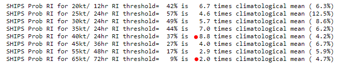
Interestingly, one of the tools we use to forecast the probability that a storm will rapidly intensify, SHIPS guidance, failed also. Early on Tuesday morning it only showed about a 2-3x above normal chance that the storm would intensify from a 50 mph tropical storm to a 100-125 mph hurricane. Yes, that is above climatology, but it’s not exactly anything impressive given what we’ve seen in recent years.
By Tuesday afternoon, those odds had increased to 5-9x above normal. But even this only showed 2x above normal odds that we’d get to 140 mph+. There were finally some hints available by mid to late morning on Tuesday, but nothing that would have offered a meaningful forecast improvement over what the NHC had (which called for 20-30 mph of intensification over 12-24 hours).
So the first question is, why did Otis do what it did? Probably a combination of a couple things. First, Otis was placed ideally in an environment that facilitated constructive wind shear. When we discuss wind shear it’s usually referenced in a negative sense; wind shear inhibits and destroys storms. Well, in occasional cases, as we’ve witnessed in the Gulf with Ian, Delta, Zeta, among many other storms in recent years, the wind shear can actually be constructive and help ‘vent’ the system. In this case, Otis was optimally placed in the right entrance region of the jet stream.
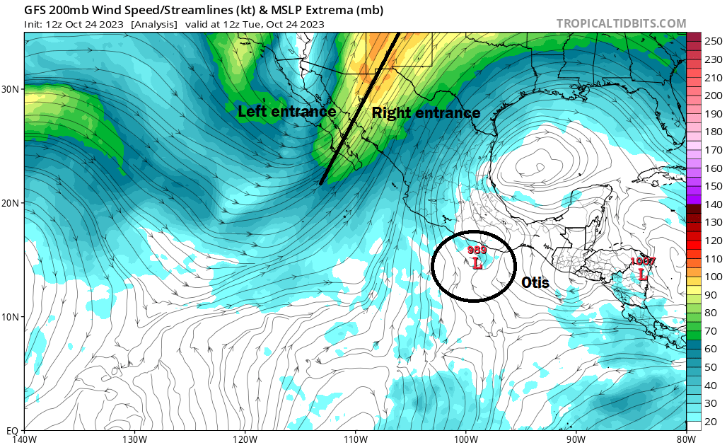
Storms are aided in intensification when placed in the left front or right rear (entrance) of the jet stream. Why? In that portion of the jet stream, the winds aloft diverge, meaning they either are moving in opposite directions or stronger wind is diverging away from weaker wind. Upper level divergence leads to rising air. Rising air is necessary for storms to form and maintain, and thus surface pressures tend to fall in this region of the jet stream as well.
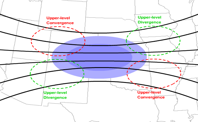
Otis wasn’t exactly square in the middle of the right entrance region, but it was there. Additionally, Otis tracked right over an area of 31°C sea surface temperatures.
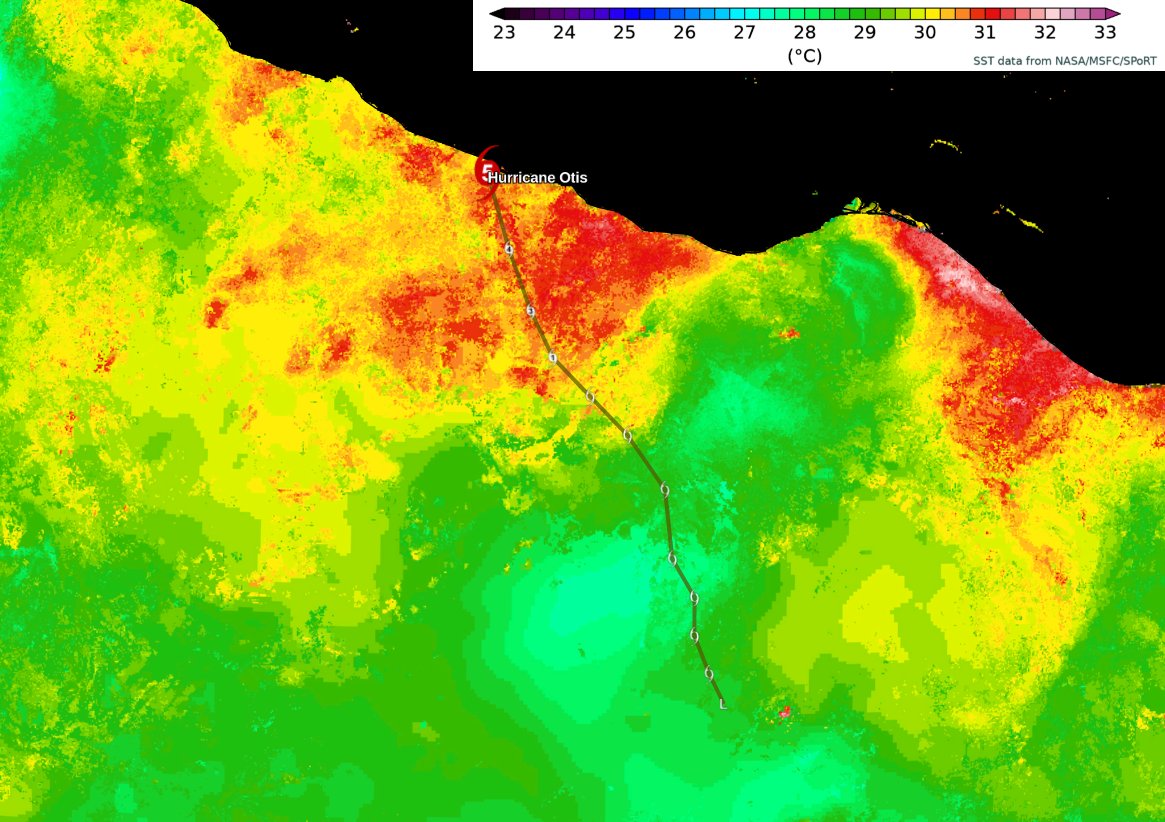
This rich warm water did not hurt matters at all.
So how did every reliable model we use miss this? That’s for graduate students and researchers to answer in the coming years, because I have no formal idea. There was something about Otis that models just could not capture and translate to RI. Human forecasters, recognizing the setup were able to mitigate some but not all of the underforecast issue. Otis’s smaller size may have also contributed. My hunch is also that if Otis had tracked, say 30-40 miles east or west of where it was, it would not have gone off to the races like this. It was simply perfectly placed to optimize intensification.
A less sexy explanation? Otis was almost unprecedented in the historical record. Only Hurricane Patricia in the Pacific in 2015 had a greater rate of RI than Otis. And in the modern era no massive storm has hit Acapulco.
Unprecedented outcomes are just that, and if the historical record has only one other remotely comparable event in this region, it becomes tough to expect that modeling can “capture” the concept that this would occur in this environment.
It feels like this was a combination of bad luck, bad timing, and bad placement. And it just so happened that a metropolitan area with over 1 million people was in the way.
It’s easy to sit here and pontificate about this or to say that weather forecasts are often wrong. But the thing is, they’re not. They’re often right. With hurricanes, forecasting has improved by leaps and bounds in the last 20 to 30 years. Perfect? No, but often more than acceptable. A failure like this shocks us because we aren’t actually used to forecast failures of this magnitude anymore! 100 years ago? Sure, this was fairly routine. But in the 2020s, we have standards and expectations for weather forecasts, and clearly this was a shock to the system. Busts like this remind us that it’s an imperfect business and there is still much work to do. The work to be done to understand Otis will take time, but we will certainly see many research papers in the coming years.
Weather update: Tammy, Texas rain, and continued wintry weather north
Just a quick punch list of items we’ll be watching over the next few days.
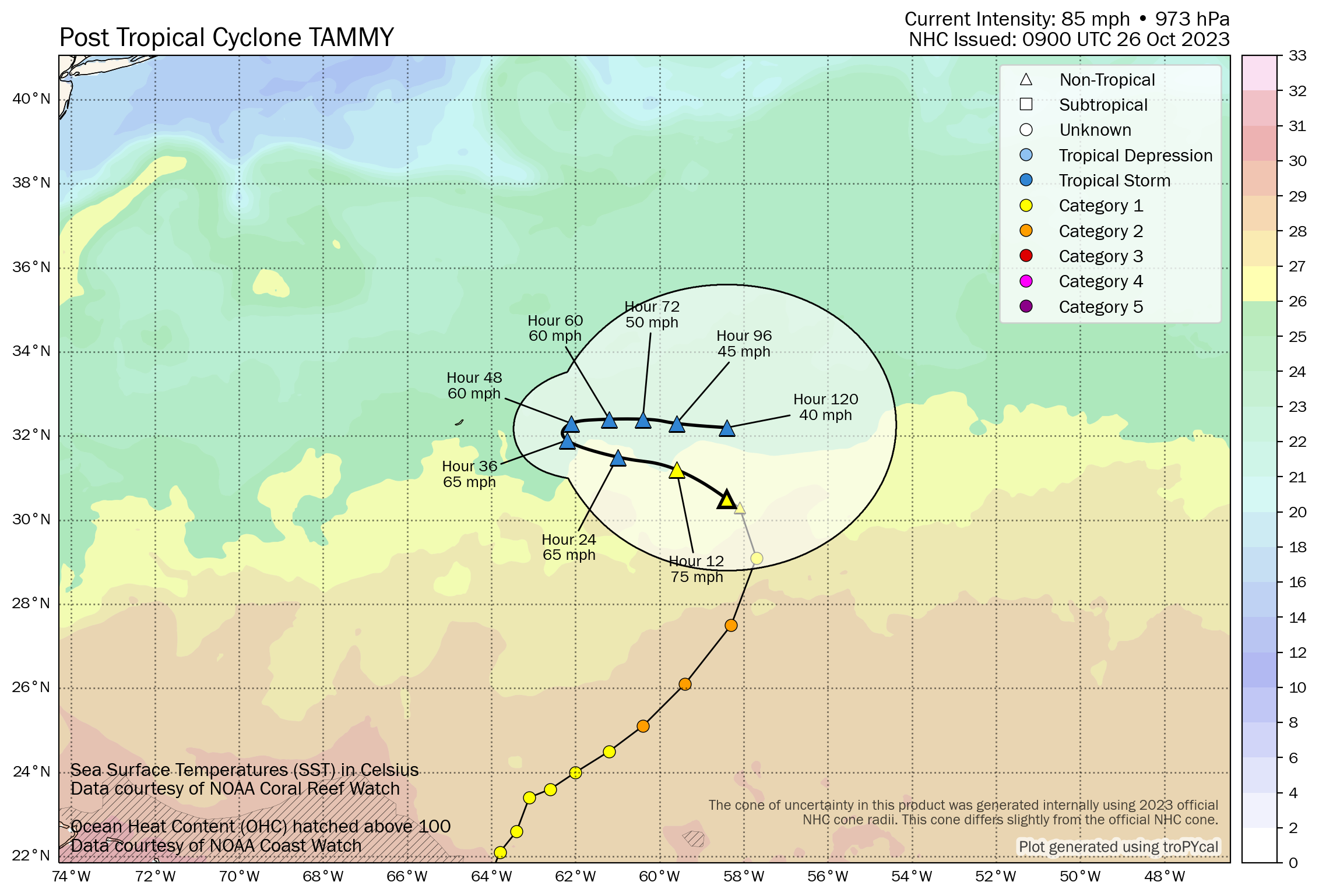
Hurricane Tammy’s final advisory was issued this morning, as it has transitioned into an extratropical entity, or something akin to a strong nor’easter. It will meander east of Bermuda for a few days, and there is some chance this could reacquire tropical characteristics at some point. It won’t go quietly, but hopefully any impacts to Bermuda are minimal.
Flash flooding concerns will be in the forecast in the southern Plains over the next few days, meandering from Texas into Arkansas. Generally 3 to 5 inches of rain is possible in spots. But higher amounts are a virtual certainty. South of Dallas, the 24 hour rainfall totals in Hood and Somervell Counties are estimated to be close to 10 inches.
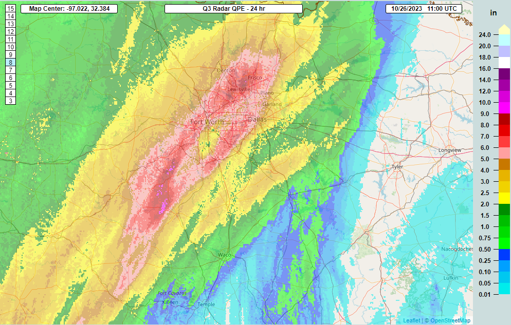
Numerous flash flood warnings are posted in North Texas and Hill Country this morning as heavy rain falls and spreads south and east.
Snow will continue in the northern tier. Over a foot fell in Helena, Montana, with snow spreading into North Dakota. Snow should wind down tonight from west to east.
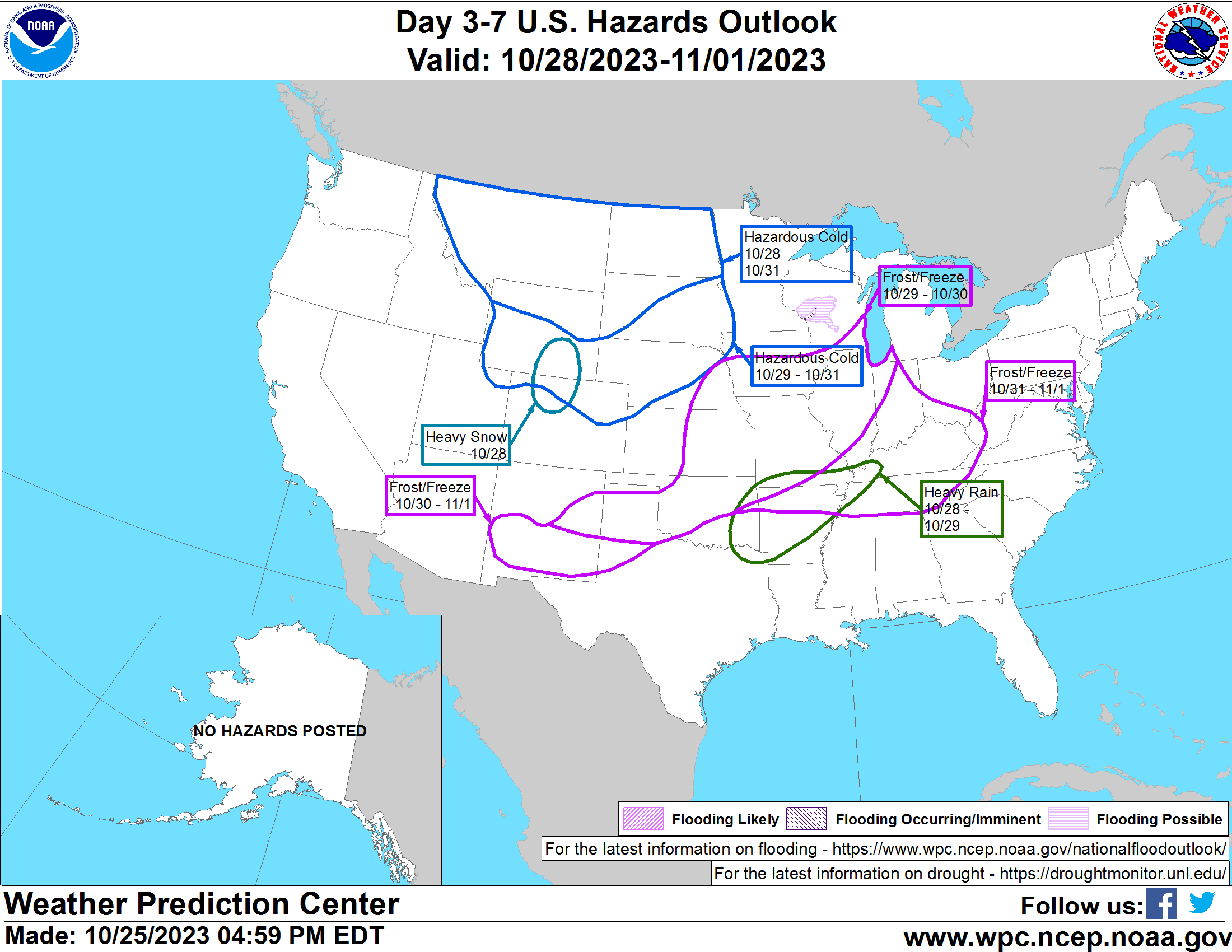
The hazards map from the Weather Prediction Center is lit up for days 3 to 7 with cold infiltrating from Canada this weekend in the North, the aforementioned heavy rain in mid-Mississippi Valley, and frost and freeze risk from near the Permian Basin and southern New Mexico across to the Ohio and Tennessee Valleys. We’ll have more tomorrow!
Forecasting tracks have greatly improved even in the last 5 years. Intensity forecasts however, remain a challenge. There are so many examples to choose from, Harvey for instance.
The track was spot on, the intensity, not so much. Harvey was forecasted to be a strong TS at best. Instead it blew up into a 4 and could’ve made a run for category 5 if it had a few more hours over water.
Is this scenario possible to happen near Houston, Miami, New York, New Orleans, etc? Or near other major cities in Mexico? If so, I hope the meteorologists do dissect this case study and *hopefully* find a root cause for what happened. A storm that intensifies like that over Galveston/Houston with 12 hours of warning would be very, very bad.
Also, poor Acapulco. Very little media coverage about it and I’m sure they are desperate for life-saving equipment and supplies. I hope their emergency response teams are able to save lives.
Theoretically it could happen anywhere, although with higher or lower probability depending on the location and time of year.
I did talk to a researcher about this, and she said that the odds of this happening in, say the Gulf were probably much lower. There is a lot more observational capability in and around the U.S. coast than there is in the Pacific off Mexico. So there are fewer blind spots that exist in terms of acquiring data and information that could be useful. And we’d probably have reconnaissance in there 24/7 or close to it. We really need to fill observational gaps elsewhere in the world though…it would help those areas but it would also contribute to general improvement in overall weather forecasting too, as the initialization of modeling is often the most critical thing to accomplish.
What about considering the eclipse that happened last week, also in relation to what happened in 2017 with the eclipse that preceded Hurricane Harvey . Seems there could be connection.
More than likely coincidence.
GREAT graphics & info on Otis 👀 TY for deconstructing these elements – I’ll be rereading this several times…
… real time physics shocks us = we’re all humbled again… negatively-outcomed constructive wind shear 😱
Q: fantasy land GFS modeling shows something very unsavory popping up in the Caribbean towards Cuba & FL around the 9th – is there any weight to that?
… so grateful for the Eyewall ⚘
Thanks, Cat! As noted today, yes, there may be something to watch in the Caribbean, but details are TBD. It would likely track north or north-northeast. In terms of how quickly it could develop or what form it could take, I’m not quite certain yet.
Did Michael do this too? It was forecast to be a weaker hurricane but hit Florida as a Cat 5.
To a lesser extent, yes. I don’t think most expected Michael to be a cat 5, but it seemed a little more plausible than in this case.