Welcome to Tuesday! Today, we’ll touch on the Texas wildfire situation, severe weather chances in Texas and the Deep South this week, a series of storms in the Canadian Maritimes, and update the Sierra snowpack situation.
Headlines
- Rainfall will remain a bit sparse in the Texas Panhandle with some additional fire weather risk down the line.
- Severe weather continues to look like a decent potential in the Deep South and along the Gulf Coast late week.
- Several storms to impact the Maritime provinces of Canada with a wintry mix and wind.
- Weekend blizzard allows Sierra snowpack to shift above normal in many places.
Texas wildfire update
Wildfires continue in the Texas Panhandle, with the infamous Smokehouse Creek fire still only about 15 percent contained as of this writing. (Update: That is now 37 percent contained as of 9 AM Tuesday)
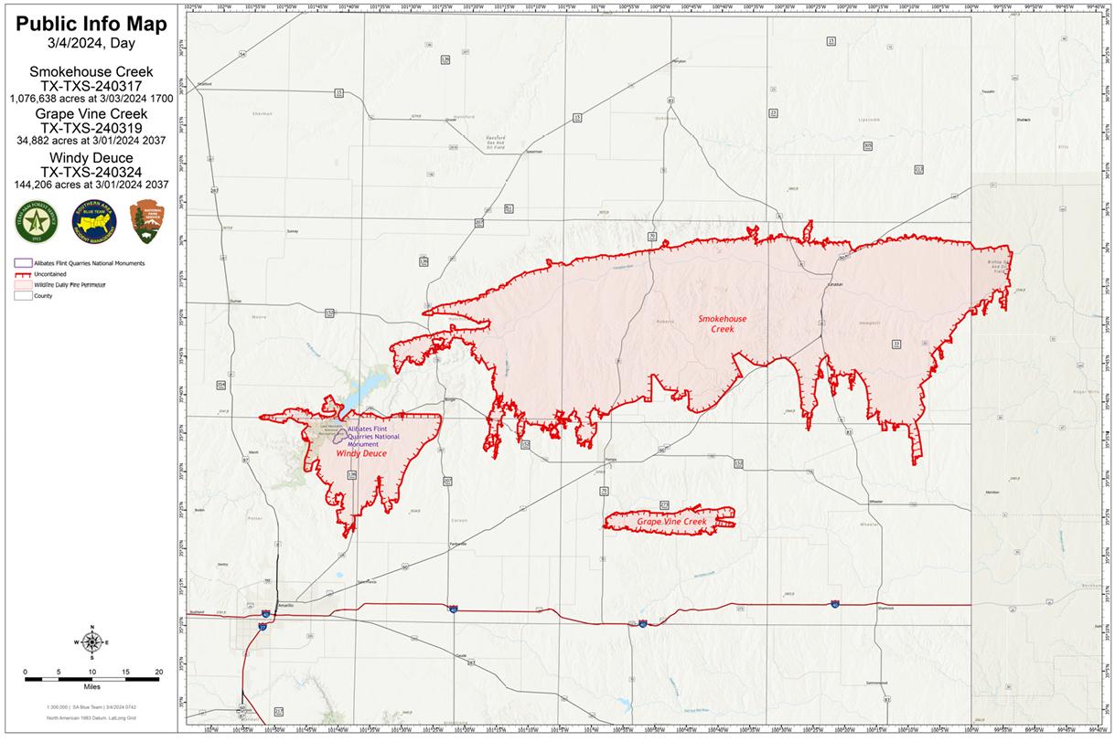
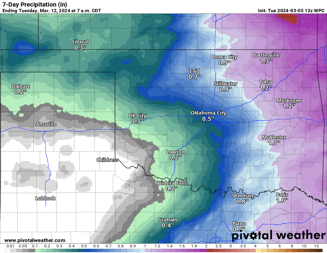
Rainfall will continue to likely be at a premium in West Texas and the Panhandle over the next 7 to 10 days, with only about a quarter-inch or less expected in the region, mostly from a passing system later this week (that could once again also bring snow to the region, mainly north and west of Amarillo).
It is likely that we’ll see drought expand into this region eventually. It technically remains mostly drought-free, but one would assume that will change. Thankfully, in terms of wind, much of this week looks fairly benign in the region. But by Thursday or Friday, a combination of stronger winds and lower humidity could again raise fire danger. At this time, the strongest wind doesn’t look too alarming, but any sort of setup now with minimal forecast rain can be of concern. The Storm Prediction Center has outlined Thursday as having a 40 percent probabilities for a critical fire weather day.

We will see how this further progresses through the week or if any rain or snow can drift farther south.
Severe weather & heavy rain from parts of Texas into the Southeast Thursday-Friday
The storm system coming out of the West later this week continues to look like it will produce the chance of strong to severe thunderstorms from Texas into the Deep South Thursday into Friday. Part one will develop east of the Texas Panhandle on Thursday afternoon with a slight risk (level 2/5) for severe storms across interior Texas.
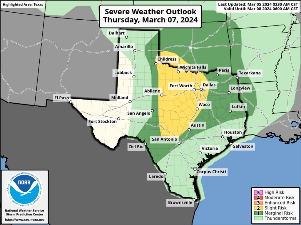
Thursday’s risk includes Dallas and Fort Worth. There are still some uncertainties on the exact timing of some features that will drive severe storms. This especially muddies the risk of tornadoes. But hail and strong winds will probably be a bit more possible on Thursday evening across North Texas south through parts of Hill Country.
That slides east for Friday, with storms possible across East Texas, southern Louisiana and close to the Gulf Coast in Mississippi, Alabama, and the western Florida Panhandle.
Like Thursday, there are uncertainties that exist in exactly how robust the storm itself will be and how much Gulf moisture gets dragged north. So this forecast is fluid. Higher risks may be farther south even in the highlighted area.
In addition to severe weather, heavy rain and a slight risk (level 2/4) of excessive rainfall exists in much of the Deep South for Friday. Total rainfall may be 4 to 6 inches near and south of Atlanta.
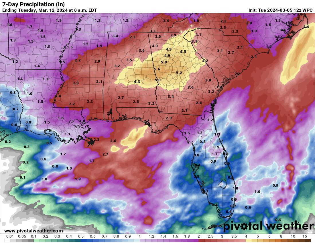
This could cause localized flooding issues in the South.
Canada update: Maritime snow and ice
Many of our readers come to us from Canada thanks to our coverage of Hurricane Lee last year. I just wanted to provide a quick update on Canadian weather today. The Prairie provinces are cleaning up after a healthy snowstorm this past weekend and yesterday. Moving forward, the attention will shift to the east coast with the Maritime provinces likely seeing storminess in the coming days.
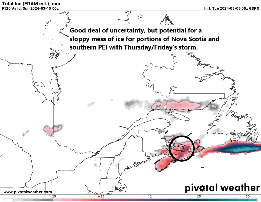
One storm system moves in later today and tomorrow, followed up by a stronger system Thursday into Friday. Another system is possible early next week as well. Each of these will deliver rain, a wintry mix, and wind. Ice totals through the weekend are shown above as forecast by the GEM (Canadian) model. Snow totals should be in the 15 to 25 cm range for eastern New Brunswick, PEI, Cape Breton Island, and southern Newfoundland.
What will be interesting is if Monday‘s storm can indeed form as shown on some modeling. If we look at the European ensemble model, which is running the model 51 different times to give a spread of outcome possibilities, you can see a pretty healthy difference among ensemble members as to the placement of the surface low pressure system on Monday.
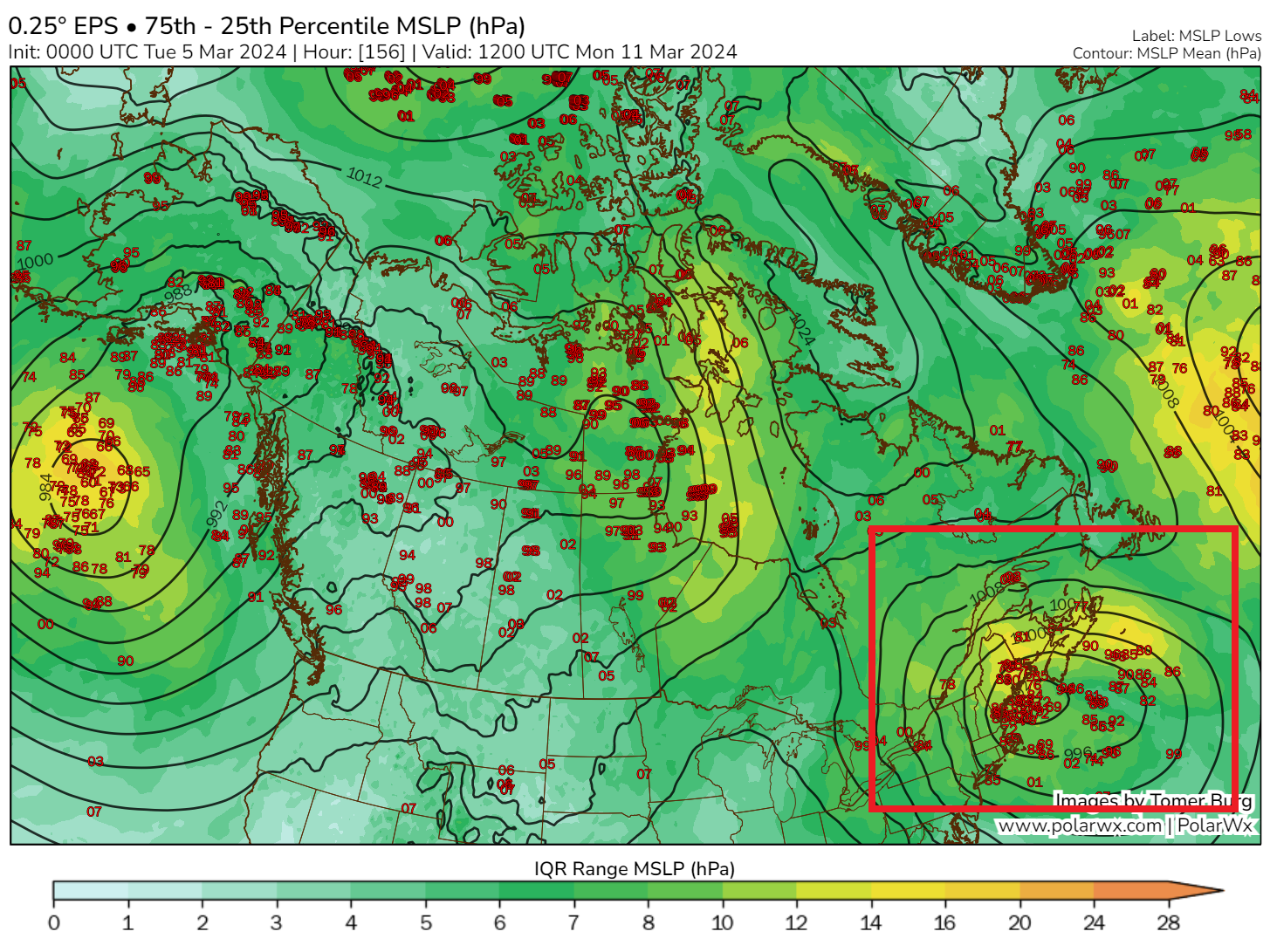
Some show it near New England, while others are over New Brunswick or south of Nova Scotia. So there’s inherent uncertainty here. This will matter in terms of precipitation type and wind experienced in the Maritimes early next week. Not the strongest storm of the year, but something to keep an eye on.
California snowpack recovers to near or above normal
The National Weather Service in Sacramento published a snow total map yesterday highlighting some of the big ticket totals in the Sierra. Sugar Bowl wins the prize with 126 inches reported. Soda Springs along I-80 at Donner Pass recorded 116 inches.
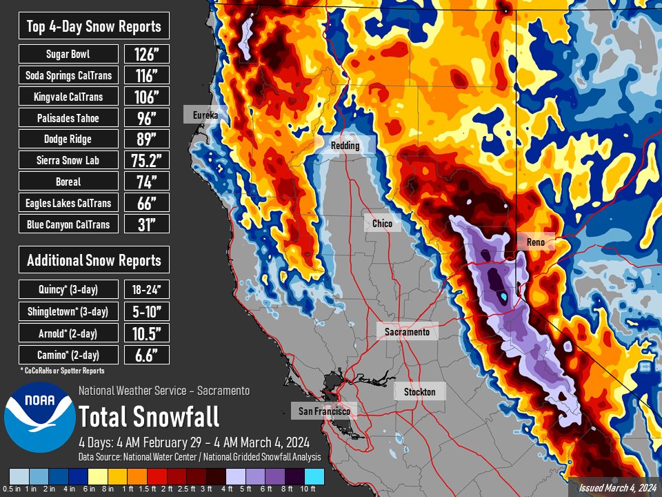
As expected, this storm helped the Sierra snowpack — a lot. The water in the northern Sierra snowpack went from 92 percent of normal to 111 percent. The central Sierra saw even more help, going from 77 percent of normal to 104 percent of normal. The southern Sierra saw good improvement as well and now sit just shy of normal.
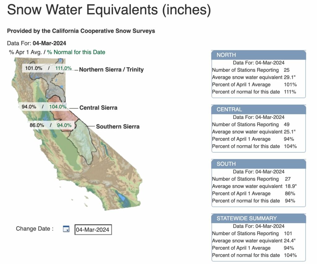
Some additional improvement will occur in the northern half of the region, but precipitation is expected to slow down considerably for the next 2 weeks after that.
Hi Matt is there a noticeable impact to air quality here in Houston with the fires in the panhandle? Thank You
I think we had a bit of impact over the weekend behind the cold front, but now that winds are a bit more variable, any impact is probably minimal. Some haze may occur, but that’s also due to the pattern we’re currently in. So the short answer is: Not meaningfully.
I’ve been near a wildfire before. It was by the road on the other side of the highway, but I remember the intense heat I felt, and I was inside my vehicle. Shocked me. It wasn’t even a big fire. You can’t outrun those things once they get going.
All thoughts out to those in the Panhandle.
Hurricanes seem safer.