Things were generally not super impactful yesterday, so we took it off. Our philosophy here is to try not to create a significant story when just a minor one exists. Today, we’ll discuss what’s happening with tomorrow’s severe weather chances and flooding chances. Big hail may be a story for portions of Texas, Louisiana, and Arkansas, while Alabama and Georgia face another wave of heavy rain that could produce flash flooding issues on very saturated ground.
Headlines
- Large hail possible tomorrow from East Texas into northern Louisiana and southern Arkansas.
- Heavy rain may lead to flash flooding in spots, particularly in Alabama and Georgia, where heavy rain already fell this week.
- Rain and mountain snow returns to the Northwest and southwest Canada.
- More rain for the Northeast, with wintry precip winding down in the Canadian Maritimes.
Sneaky soaker slides across the South
A storm system tracking across the country tomorrow promises to bring a fairly lively day of weather from Texas into the Deep South with severe storms and flooding possible.
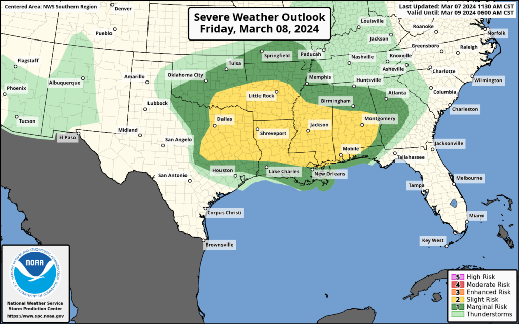
A rather broad area of slight risk (level 2/5) is posted across the South between Texas and Oklahoma and Alabama for the potential of severe thunderstorms on Friday. Storms could include tornadoes, strong winds, and somewhat larger than usual hail risk. The Storm Prediction Center has highlighted a hatched area on their maps between about Tyler, TX through southern Arkansas, including Shreveport and Texarkana.
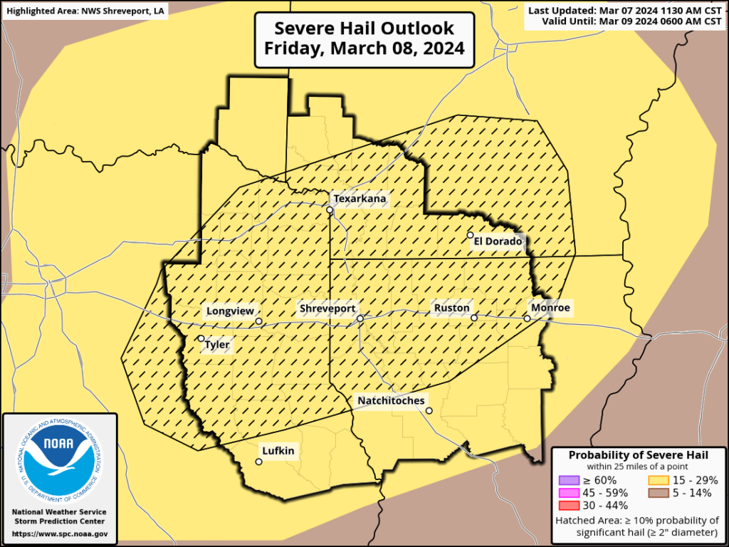
Hail in excess of 2 inches in diameter (hen egg size or bigger) is a possibility here, as we’ll have a few conditions in place in that smaller area that tend to historically favor bigger hail risk.
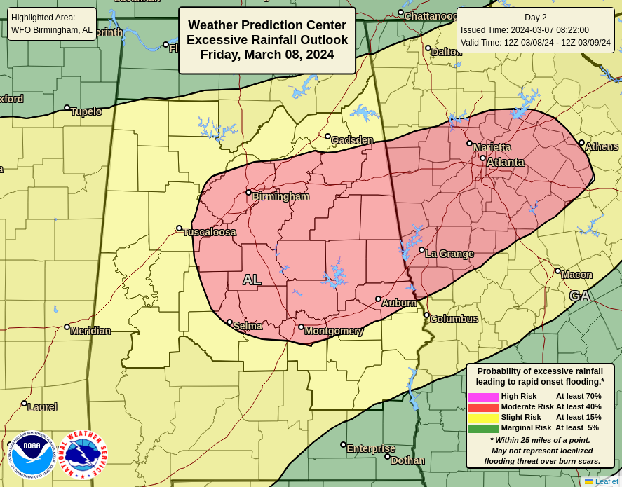
In addition to the storms (which spread across Georgia to the coast on Saturday morning), heavy rain is once again a good bet in the Southeast. After a storm delivered nearly 4 inches of rain to Atlanta earlier this week, another 2 to 4 inches may fall tomorrow night into Saturday morning. Thus, flood watches have been hoisted across Alabama and Georgia, including Birmingham and Atlanta, along with a moderate risk (level 3/4) of excessive rain and flooding for those areas.
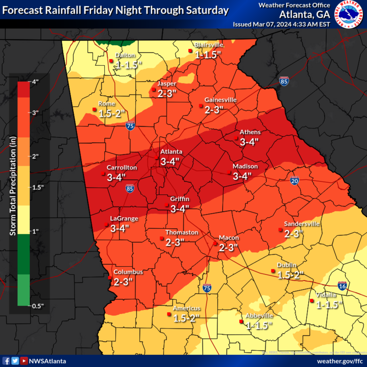
Some places only need 1 or 2 inches of rain over 2-3 hours to lead to flooding, which will certainly be attainable tomorrow night in Alabama and Georgia. While not a massive flooding event, you should expect roadway flooding issues across that region later Friday night and Saturday morning, as well as minor to moderate flooding issues on rivers in the region through early next week.
Northwest stormy pattern cranks up
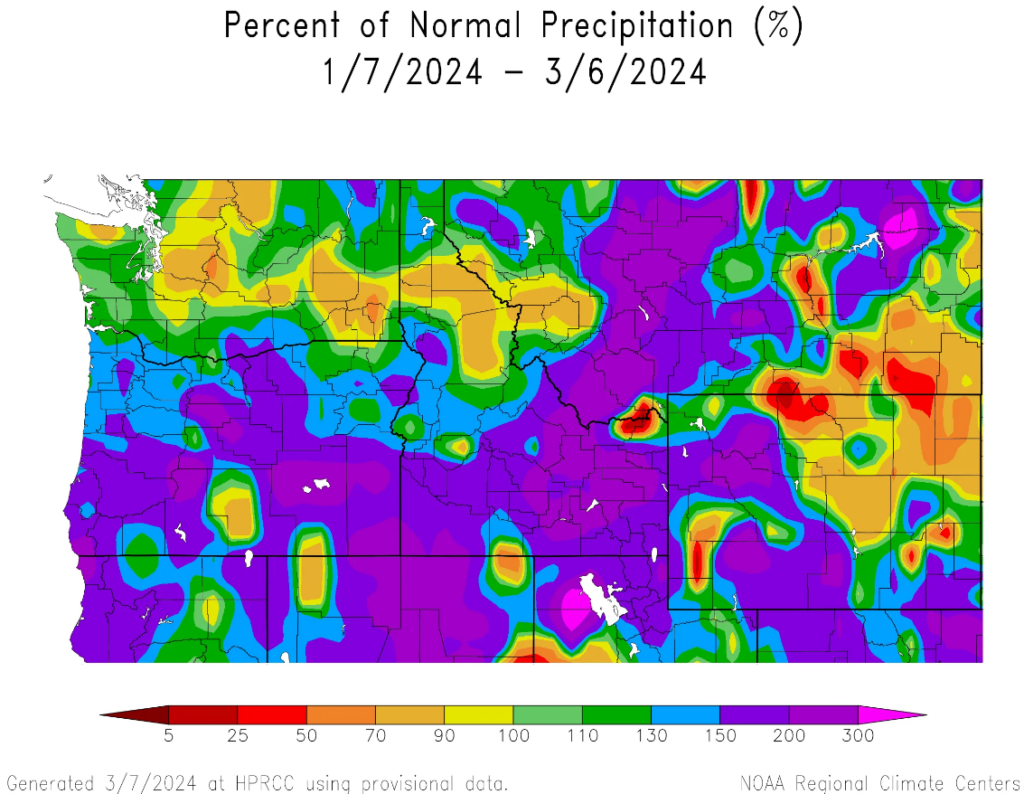
While California and to a lesser extent Oregon have been dealing with occasional big storms, the far northwest including Seattle have seen normal to below normal precipitation over the last couple months overall. Not terrible, but not great either.
That will change a bit over the next week. A series of storms between this weekend and next Tuesday will help mitigate recent dryness some. Anywhere from 1 to 2 inches will be possible from Vancouver south through Portland with higher amounts and fairly good snows in the Cascades, Olympics, and the Coast Range with slightly lower but no less helpful precip south into northern California.
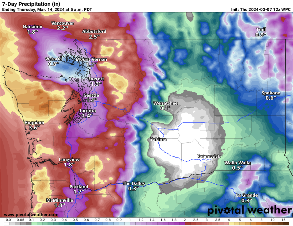
The Sierra may see another foot or two of snow, especially the farther north you go. Whatever the case, the parade of storms will be needed, as the pattern is likely to turn warmer and drier in the West heading into later next week.
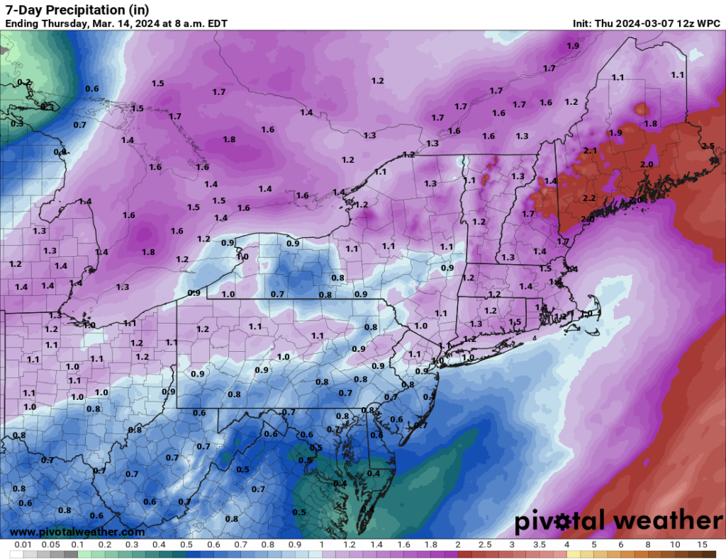
Northeast sees more rain
It’s been a wet stretch for a long time it seems in the Northeast U.S. As we discussed storms earlier this week for the Canadian Maritimes, the Northeast will get the rainy side of that. Another 1 to 2 inches of rain is possible for New England, the heaviest of which should occur in Maine over the next 3 to 5 days.
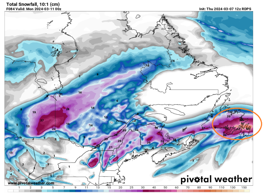
It continues to look at if Atlantic Canada will see a helping of snow and ice over the next couple days. Anywhere from 30 to 50 cm of snow and 30 to 50 mm of ice are expected in Newfoundland. The most ice accumulation will likely occur on the south side of the Burin and Avalon Peninsulas. Ice will also occur for parts of Cape Breton Island and PEI. In addition, snow will occur through evening across PEI and southeast New Brunswick.
The next storm Sunday into Monday should track a little to the north, which should yield a warmer outcome and more liquid than frozen precipitation across the Maritimes. Another storm is on track for next weekend.
Such comprehensive awesomeness!
💓 The Eyewall 💓
🌬 ⚘⚘⚘
I love the way you switch between inches and centimeters – very thoughtful!