One-sentence summary
After an impressive rainstorm in California, quieter weather will settle in for a few days before we watch the potential for another rain event in the region beginning around next weekend.
California cleaning up
After a wild sequence of rain in California, the time for clean up has begun.
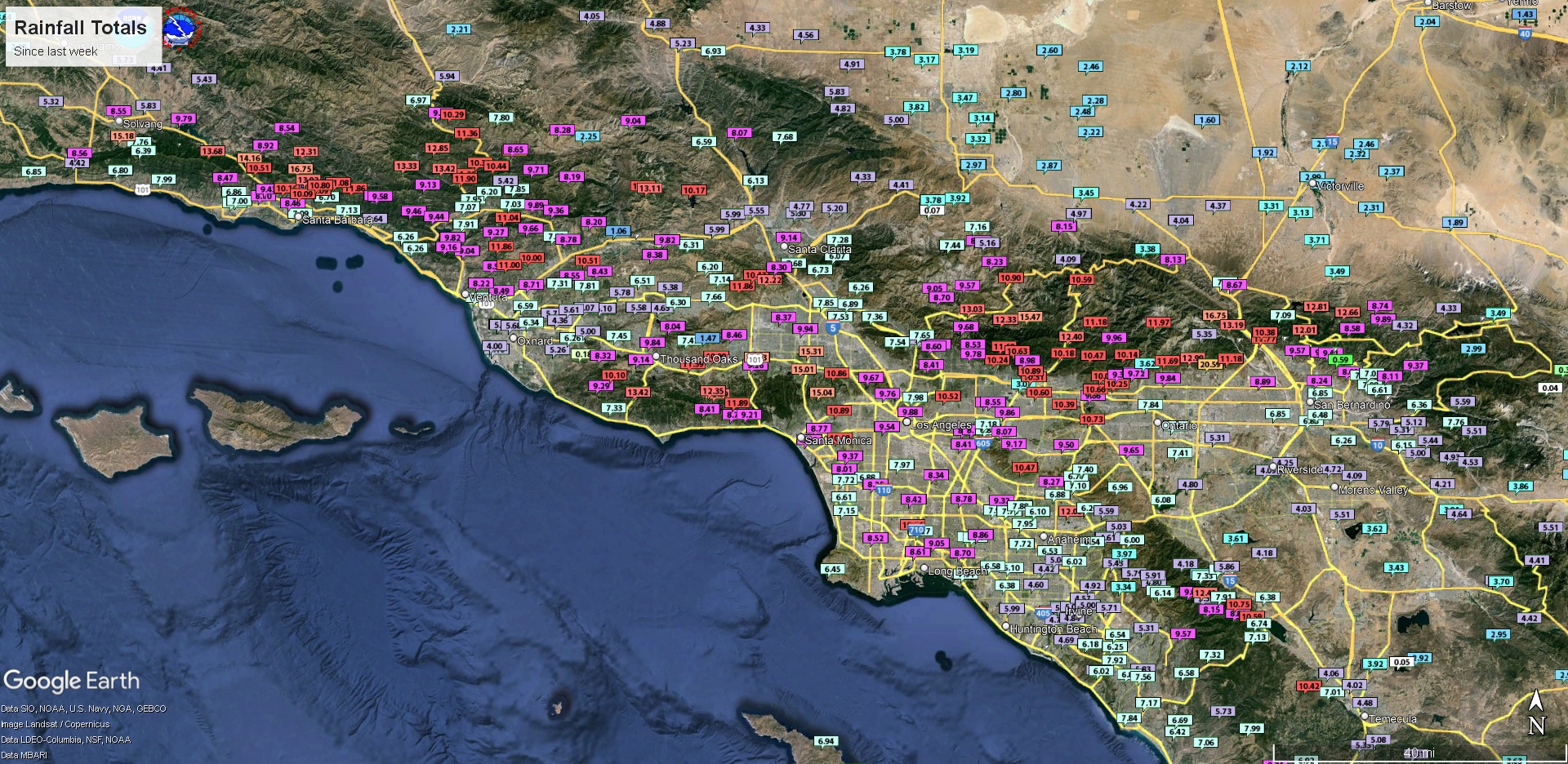
The amount of rain that fell in some places is staggering. California is always a place of extremes, and with these extremes seemingly happening more often and at greater amplitudes, it’s making for a lot of whiplash.
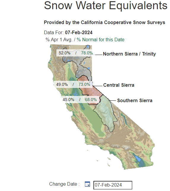
In quite a change, Sierra snowpack now ranges from 68 percent of normal in the south to 78 percent of normal in the north. Those values were 36 and 60 percent respectively a week ago. While these storms come with damage and a lot of headaches, on net this is probably good news for California. The Sierra needed snowpack replenishment desperately. A year ago, after another sequence of ferocious storms, the amount of water in the snowpack ranged from 170 to 240 percent of normal.
For the rainy season so far, San Diego has seen 7.88″ so far, about two and a half inches above normal. Downtown Los Angeles near the USC campus has recorded 15.43″, which is over seven inches above normal. Almost 90 other years back through the 1870s did not even see that much rain during the entirety of the rainy season in Los Angeles. Downtown San Francisco has seen over 16 inches this rainy season, which is about 3 inches more than usual to this point. As is typical for El Nino, the anomalies are strongest in SoCal.
What’s next? A break, but then potentially more rain
Things really do calm down for California over the next few days with one more round of rain, then some showers, then a dry stretch.
Rainfall over the next week or so should be manageable, though some residual issues due to mudslides and high water will continue. But new problems should be minimal.
Beyond early next week, things start to change again, and it’s possible we have another round of significant weather aiming for California beginning around next weekend. Why? If we look up at the jet stream level on today’s run of the European model, we can see what’s happening. Initially, California is in a calm bubble of sorts. This is what will help restore fair weather to the region.

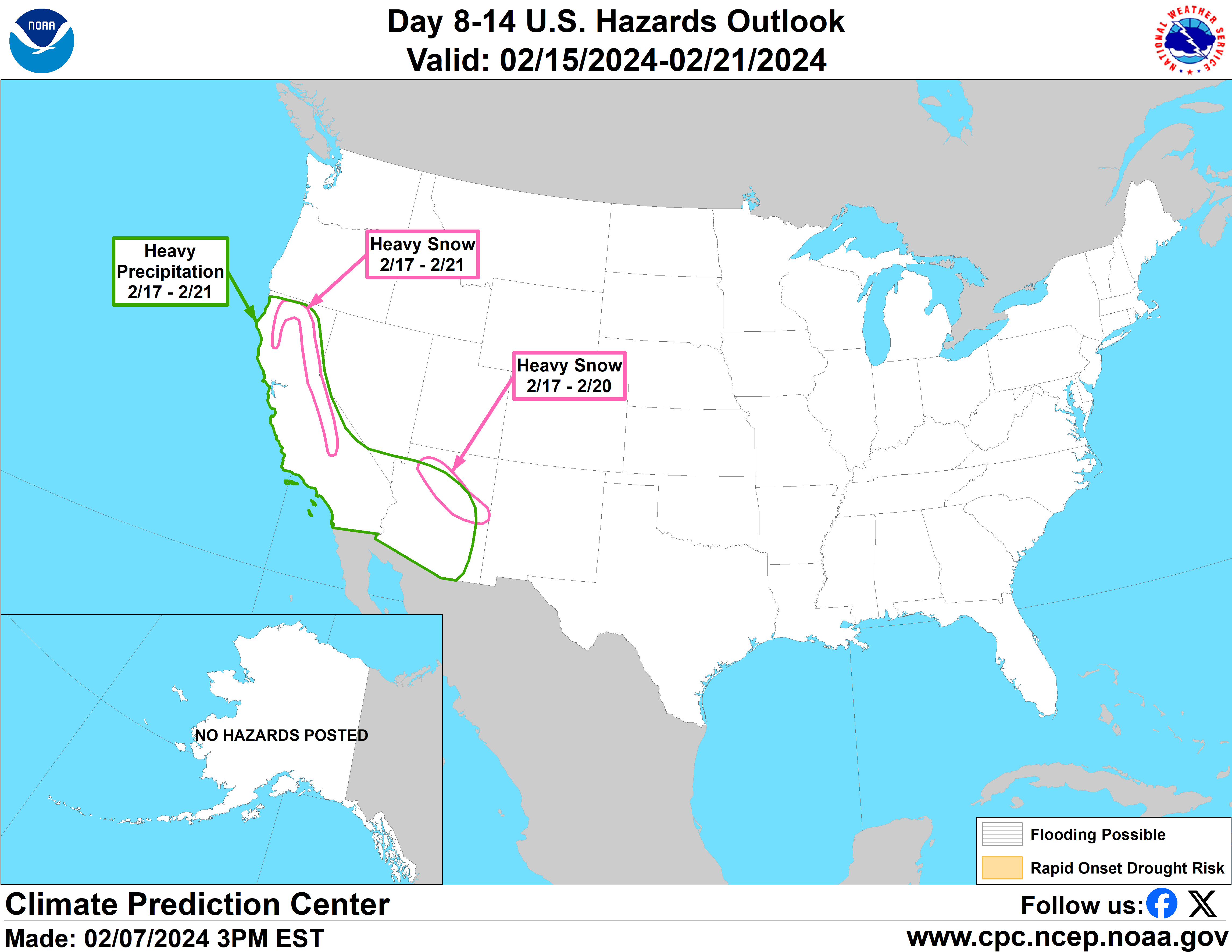
If you look out over the Pacific Ocean, you’ll see the jet stream winds again stretching and extending toward the U.S. West Coast around late next week or weekend. This shows up on most modeling and has for a few days now. Thus, it seems reasonable to think that another round of storminess may approach California around that time. In fact, the Climate Prediction Center has again highlighted California and the West for another round of heavy rain and snow risk beginning around February 17th.
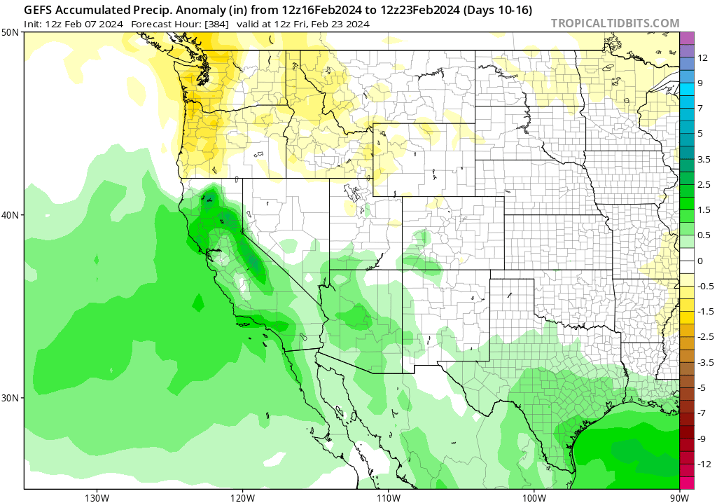
Modeling backs this up, with the GFS Ensemble from earlier today showing anomalies of about 1 to 2 inches on average across California from February 16th through the 23rd. Ensemble means tend to “wash out” extremes by design. In other words, because you’re looking at an average of a 30 member ensemble, you will lose some of those extremes in favor of a dominant signal. What we know? It will likely get wet again in California. What we don’t know? How wet.
All that said, this is looking like another potentially robust multi-day, multi-inch rain event next weekend into the following week in California. A good idea to stay tuned.
As an Aransas County Texan now living in Sonoma Valley, I appreciate your insights as we adapt to the weather issues in our new locale. There’s so much to learn, and it’s so different from the Gulf Coast weather. Keep up the good work!
thanks so very much for this forecast as I am driving from Florida to Minnesota on 2.18 through 2,21 and was worried about bad weather during my drive! You really help everyone even the average person, like me!
Thank you so much for this valuable reporting. We very much appreciate it.