One-sentence summary
A wave near the Bahamas is unlikely to develop over the next few days, but support is growing for some development of a wave emerging off Africa later next week.
Happening now: Bahamas wave unlikely to develop
Things remain quiet in the tropics for the near-term. We do not expect any development from any areas. The most prominent feature continues to be a tropical wave near the Bahamas.
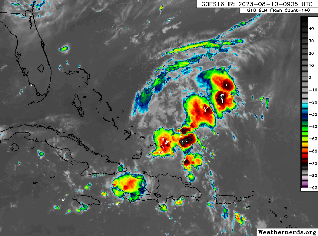
Modeling continues to view this area unfavorably, and no development is expected from it. But since we watch things closely, let’s just talk briefly about why it probably won’t develop.
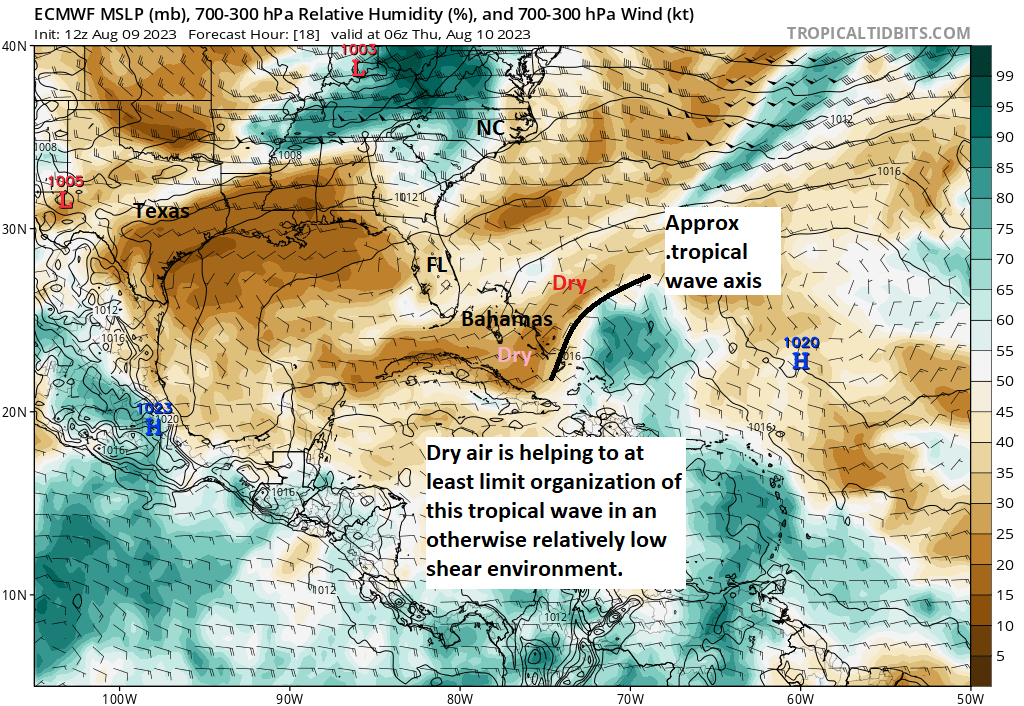
Wind shear is not the issue, as this wave is embedded in an area of lower shear. But there is a fair bit of dry air around this wave. Yesterday I noted how a surge of mid-level dry air into the Southeast this weekend or early next week would likely eviscerate this wave. That’s still on track.
But given the low shear environment, we’re sort of lucky to already have some dry air around the system. Otherwise, I think it would be a potential candidate for development. We’ll continue to watch it into the weekend, just in case. But for now, we feel confident that this will not form.
Elsewhere, things are quiet.
The medium range (days 6 to 10): Model support growing for wave off Africa to develop next week. Maybe.
The next item to watch will be emerging off Africa in the coming days. We are beginning to see some actual model agreement now between the GFS and Euro that suggest a wave or waves will develop later next week. The trouble right now is that there are a lot of disturbances in that part of the world, and it’s tough to really say with any confidence which one it will be that goes, if any do at all! The European ensemble model shows this really well.
Recall, ensemble models are basically when you take the same model and run it 30 (GFS) to 50 (Euro) times with tweaks each time. If you look at the individual ensemble members, you get a more realistic spread of potential outcomes. Indeed, when you look at the European ensemble right now, you can make absolutely zero sense of things. Which wave? When does it develop? Is it multiple waves? What is life?
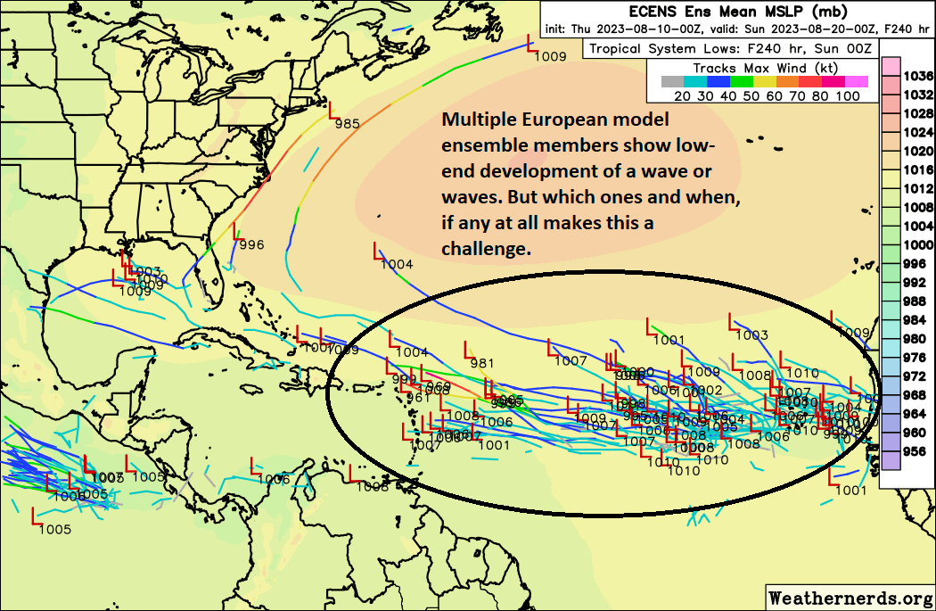
As a forecaster, all I can do is look at that and tell you, “Hey, a wave emerging off Africa in 3 to 5 days has a good chance of developing later next week.” That’s where our focus will be in the medium range. Confidence is not terribly high given how the Atlantic has underachieved this season. And quite frankly, this may be telling us that the Atlantic ends up too chaotic for development. That’s very much a possibility as well. We’ll see how this evolves.
Fantasyland (beyond day 10): Who knows?
I’ll be honest with you. Given the uncertainty surrounding next week’s wave off Africa, it doesn’t make sense to tinker much with the “beyond day 10” period. I personally expect this medium-range wave(s) to be the main storyline heading into the longer range, should it develop. Behind that, we’ll continue to watch the African wave train do its thing as we head toward September. You can count on us for sober, level-headed, no hype coverage of all of it in the coming weeks. If you haven’t already, tell your friends or family on the coast from Newfoundland to New Orleans to Nicaragua that we’re here to help folks make sense of hurricane season!
The Atlantic being too chaotic for development – that made everything go still ☺️
The verbal visuals given here are marvelous 🌺
Having followed many hurricane blogs, websites, apps and forums over the last 15 years…..I really appreciate your “ sober, level-headed, no hype coverage”
Thank you!!
You guys are the best!
Should Katy evacuate?
I love the “ sober, level-headed, no hype coverage” that doesn’t happen anywhere else. You just put it out there. Thanks so much for that. I live in Galveston so I follow you closely. Thanks again for less anxiety.
I’m a retired scientist who, for years, religiously consulted the daily NHC site during hurricane season. Then I found Space City Weather shortly after it started and The Eyewall from Day 1. It’s so great not to have to plough through all the nuances to have realistic information about the weather. You make it easy and frequently amusing, which is much appreciated. I’d be lost and devastated if ever you stop your analyses (I almost have withdrawal symptoms when there are none for the weekends). Thanks for a magnificent service, both of you.
exactly what he said ☺️
and ditto, what he said.
sitting at a cafe where they have “Fox Weather” on the TV (didn’t know it existed) and reading The Eyewall – talk about two extremes!
What is life? If only we knew.
Still loving your content. 😁
Given your comments today on Eyewall, Matt, why in the world would NOAA double down on its estimate of the number of tropical storms and hurricanes this year? Hot ocean temperatures are one thing, but with El Nino conditions, high wind shear, dry air and Saharan dust, hurricane season seems to be sort of a bust so far. Are forecasters simply erring on the side of caution, or do they really expect the next 60 days to be a whirlwind (pun intended) of activity?