One-sentence summary
The near-term is quite quiet, and while there are a couple things to watch beyond the weekend, there’s nothing of any serious concern at the moment.
Happening now: Really nice for August
Things are quiet, and they’re expected to remain so over the next 3 to 5 days, with no areas of any real concern, and nothing rogue on any modeling. If we look at satellite this morning there are at least a couple areas that stand out. Certainly the storms over Missouri are notable. There is storminess off the Southeast and Mid-Atlantic coast, a disturbance north of Hispaniola, and another tropical wave entering the Windward Islands.
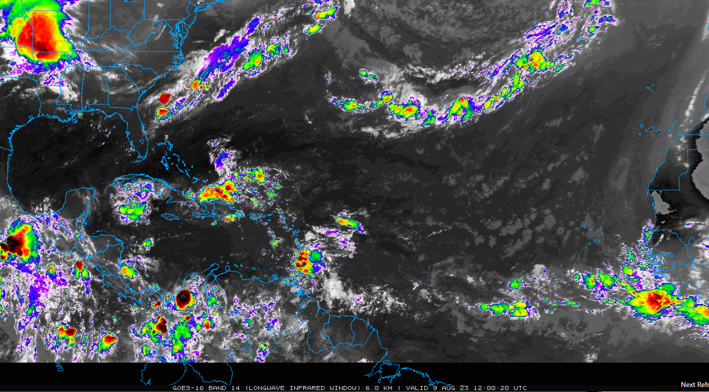
None of these areas looks particularly menacing though from a tropical development sense, and we expect the next five days to be storm-free.
The medium range (days 6 to 10): Next candidate for development emerges off Africa
The next period should start with a tropical wave in the Bahamas that will likely scoot toward Florida and the Gulf around day 6 (next Monday or Tuesday). A rather aggressive shot of dry air dropping south into the Southeast should act to really inhibit any development of that wave.
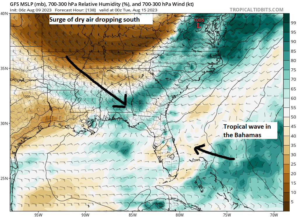
My guess is that tropical wave will either be dragged northwest into the coast in between the Bermuda high and the Texas heat dome, or it will get shunted off to the south and west toward Mexico. Or it may just end up getting dismantled. Regardless, no development is expected.
Behind that wave, we should see another one moving into the Antilles without much organization. Behind that wave another one should be emerging off Africa this weekend, and we’ll see where we are at the end of the medium-range period. The Euro ensemble (50+ runs of the same model with various tweaks), as it has been much of summer with main development region (MDR) waves is rather aggressive in developing this as it comes across the Atlantic, reaching about half to two-thirds of the way across by day ten. The operational Euro is emblematic of this, and you can see that on its day 9 forecast it shows modest development just east of the Lesser Antilles. This map shows what we call vorticity at 700 mb, about 10,000 feet up in the atmosphere. Vorticity can tell us where atmospheric disturbances are or how “robust” they are. You’ll periodically hear this referred to as “energy in the upper atmosphere” by some meteorologists.
Anyway, this shows that on day 9 there is one wave gradually approaching the Caribbean islands and another emerging off Africa.
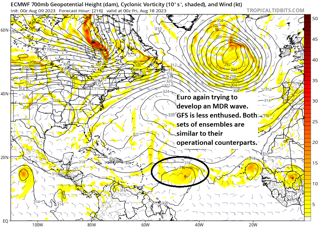
The Bermuda high is expected to weaken a good deal by days 8 to 10 or so, which might imply the escape hatch out to sea will be open. Still, it’s 10 days out so we have a world of time to watch this evolve, should it even develop at all. As noted, the Euro has had an aggressive history this summer in the MDR, and it has not exactly worked out, so I’m not as confident as that particular model is in development.
Fantasyland (beyond day 10): No signs of anything specific for now
The good news about the fringe forecast period is that there is no real sign of anything specific showing up in modeling that we can point to and say “we might need to watch this.” Maybe, maybe that next wave off Africa has a chance to be the next one to watch. Maybe. You choose your words carefully this time of year, so we’ll keep watching.
I read yesterday that wind shear is going to pick up, stronger than avg in the Atlantic & Eastern Caribbean. Any decent chance of that lasting till late August?
☺️
We should in theory see more wind shear than normal for late August and September. But I don’t want to bank on that too much. A lot can go wrong ha, but with a robust El Niño forming, you would anticipate the shear to be there.
Traveling up the east coast in September/October so here is hoping for relatively calm 🌊.
The Gulf of Mexico is incredibly warm right now. In a way, I hope the Heat Dome keeps sitting where it is till end of October. This will steer any storms away from the western Gulf and inhibit development in that region.
Not really that different that most years. The official temp at Galveston is 30.4, average temp on this day is 30.5. The water temps in our area have been trending normal for this time of year. Anything above 80F is considered hurricane territory.
https://www.ospo.noaa.gov/data/sst/contour/contour.small.gif
https://seatemperature.net/current/united-states/galveston-texas-united-states-sea-temperature#:~:text=86%C2%B0F&text=Today%20water%20temperature%20in%20Galveston%20is%2086.5%C2%B0F.
Correct, the Gulf as a whole is near-record warm right now. It matters to a point, as the Gulf is always warm enough for hurricanes in August and September, but being so warm likely means that a.) the season could last a little longer than normal in the Gulf and b.) the upper-bound of intensity (not the most likely case, but the theoretically possible case) goes up. Hopefully we can keep high pressure in the right spot and keep that wind shear coming.
That Bahamas wave was out best shot in weeks for significant moisture and cooler temps in S Louisiana and it’s gonna be killed by a continental air mass. Sigh.
It’s been that kind of year. When in drought…