One-sentence summary
There are several tropical systems to track but the most intriguing area to focus on lies in the Gulf of Mexico, where a tropical wave may bring beneficial rains to some lucky area early next week.
Happening now: Three waves to watch
Let’s start out with this morning’s tropical weather outlook from the National Hurricane Center. These are published every six hours during the Atlantic hurricane season, and provide a good overview of where the experts at the Miami-based center expect action over the next seven days.

Those orange-blob tropical disturbances in the eastern Atlantic are certainly eye-catching, and this is definitely the time of year when we start to worry about waves moving off of Africa, and traversing the Atlantic Ocean to threaten the United States, Caribbean islands, and Mexico. But I don’t think we’re going to have to worry too much about either of these waves.
The easternmost disturbance has a 40 percent chance of developing, the hurricane center says. I say have at it, because this system is very likely to get pulled northward into the central Atlantic Ocean. The system probably has about five days to become something before conditions become marginal to sustain a tropical storm or hurricane. So a fish storm, maybe.
The closer tropical wave has a 50 percent chance of developing, according to the hurricane center. As Matt noted yesterday, if the wave tracks more westward than northwestward, it will eventually run into some drier air as it approaches the Caribbean. Still, given its potential to get closer to the Caribbean islands, this is a wave probably worth watching a little more closely over the next week. Fortunately, it faces an uphill climb to become anything of note.
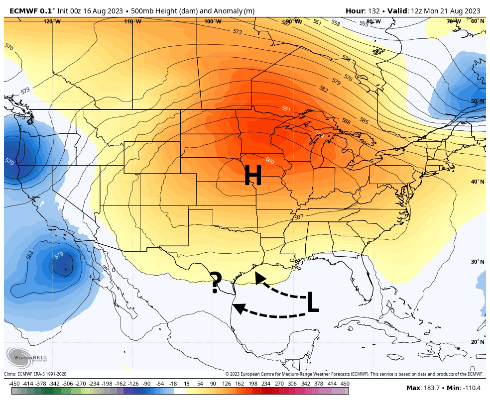
The medium range (days 6 to 10): The Gulf wave
Finally, the National Hurricane Center has highlighted a tropical wave forming in the Gulf of Mexico next week, giving it a 20 percent chance of developing. The Gulf is blazing hot, and the old adage I always stick to is that you never want to see a low pressure system there in August or September. However, in this case there are a lot of factors working against the tropical low, including its fairly rapid forward speed. So there are probably a fair number of Gulf coast residents eying the tropical system as a potential salve to drought conditions. Texas, in particular, could use a good soaking.
Whether that happens is going to depend on a rather stout high pressure system over the Central United States. The map below shows a rather intense high developing over Iowa, Missouri, Nebraska and Kansas next week. If the high is too strong, it will force the Gulf system south of the Upper Texas coast and Louisiana. If the high is further south than that, then again, it will force the wave south, toward South Texas. If the high is weaker or further north, it would allow the wave to come to the Upper Texas coast or Louisiana.
Beyond the Gulf wave, and the two aforementioned systems in the Eastern Atlantic Ocean, there’s not too much else to track in the medium-term.
Fantasyland (beyond day 10): No more Mr. Nice Gyre
There is also not much to grab on to in the models right now as we get toward the final few days of August. I do think there’s the potential for some action in the Western Caribbean Sea about 10 days from now, probably related to the Central American Gyre, which is basically a broad monsoonal low-pressure system over Central America. (A more detailed discussion can be found here). There’s no specific threat to point to, but it is not out of the realm of possibility that a tropical low could develop here and lift north into the Gulf of Mexico by late August. As this is super speculative, it’s not something I’m losing sleep about.
Nor should you.
can a CAG cause a tropical storm to develop?
Absolutely can. blog dot weather dot us/explaining-the-tropics-the-central-american-gyre/
thx ☺️
Regarding that Central American Gyre detail I tried to read / understand it, but 😂 “it’s all Greek to me.” 😂 And I have a degree in chemistry that included numerous calculus and physics courses. Maybe I should have treated it as Hebrew – perhaps reading right to left might have been clearer to my heat and humidity fogged brain! It’s good to have people like its author, Matt and Eric who DO understand this stuff!
Matt, thanks for a very understandable report of a complicated subject. Well done! My wife is asking if there is an iPhone App for The Eyewall? She has not been able to find it.
No app yet. But we’ll see how things progress over time! Thanks for reading!
I hope so.
I’m ready for some fun!
Isn’t it ironic that there hasn’t been any large storms coming out of the Atlantic, while most of the US was dealing with wild fire smoke from Canada and California and other places?