One-sentence summary
The tropics are busy, with Hurricane Hilary likely to become a severe rain and flooding threat in the low deserts of California, while the Gulf will watch a tropical wave progress toward South Texas early next week.
Happening now: All the things
I’ve always found that it’s helpful to orient myself with a map, so let’s get oriented on what’s happening by looking at a satellite image of the East Pacific and Atlantic Oceans.
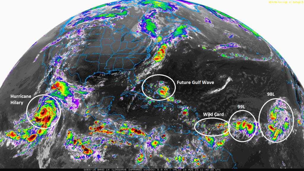
What we’ll do today is work mostly left to right from that map above and discuss Hilary, the Gulf disturbance, Invest 98L, Invest 99L, and the “wild card” area below.
Hurricane Hilary: An exceptionally rare flooding threat for the SoCal deserts
I’m going to keep this section brief this morning. We discussed Hilary’s forecast in depth in our special post yesterday evening. We will have another one for you later this afternoon. Hilary has absolutely exploded into a category 4 hurricane with 145 mph maximum sustained winds.
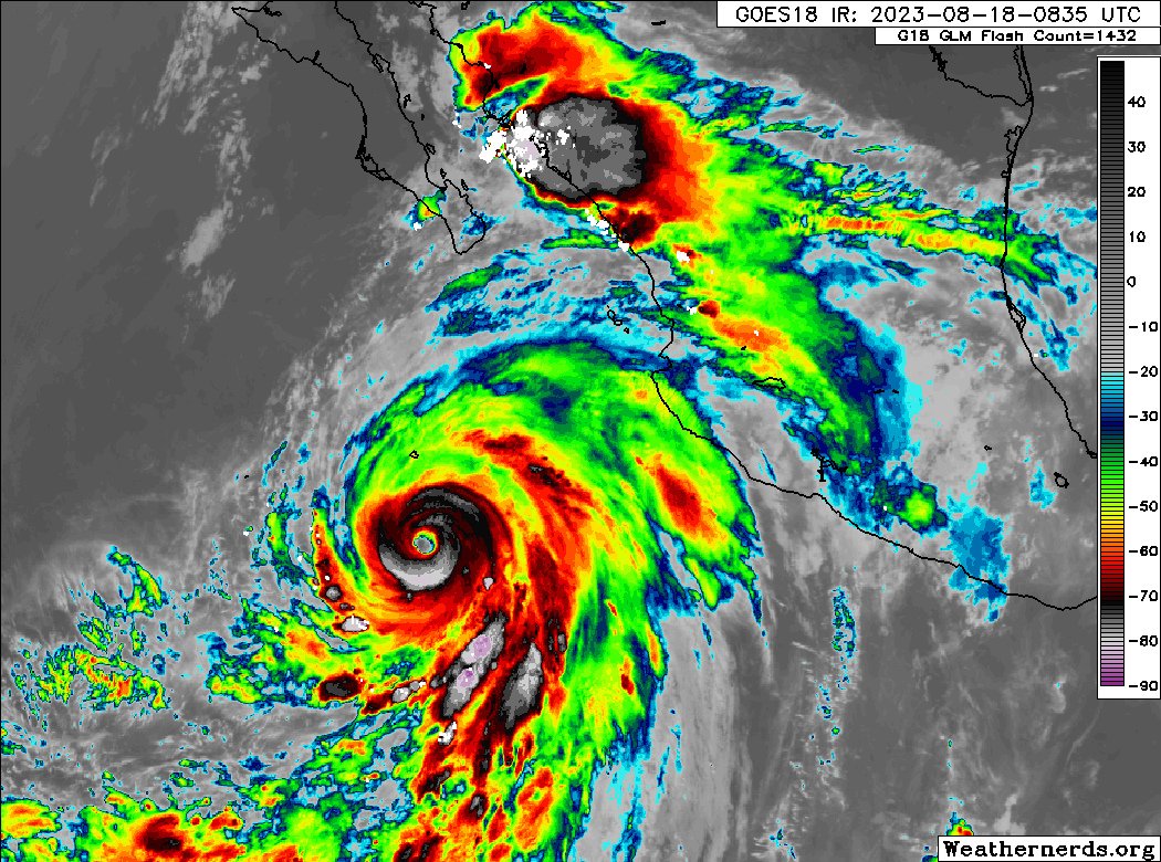
The general idea on Hilary is unchanged today, likely to come north into or just off the coast of central and northern Baja and eventually into California as a remnant tropical storm or depression. This leads to all sorts of potential issues in SoCal, but the primary one? Flooding.
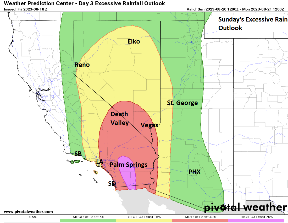
The Weather Prediction Center already has a high risk of excessive rainfall posted for Sunday for Palm Springs and the Coachella Valley. This is the first time on record that they’ve issued a high risk in the low deserts east of the mountains in California. High risks from the WPC are very well correlated to bad outcomes. Over 80 percent of all flooding-related damage has occurred during high risk days and near 40 percent of all flood-related deaths have occurred on high risk days. In other words: High risks mean business.
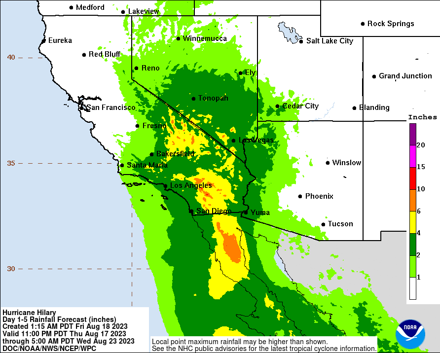
Rain totals will be exceptional for some of these areas on the east side of the SoCal mountains. This will cause significant flooding and potential damage, in addition to mudslides in some mountain areas. We’ll talk more about this later today, but as I said last night: Eric and I are quite familiar with flooding here in Houston. We encourage anyone in Hilary’s path, particularly in the deserts of California and Nevada to take this thing very, very seriously.
Gulf Wave: South Texas rains & potential development
The forecast for the upcoming Gulf system has not changed a whole heck of a lot unless you take the operational European model as gospel. Again, this thing will be hauling west. Look for it to emerge off Florida’s west coast on Sunday and make land in Texas on Tuesday. This limits how much time it will spend over the Gulf, and it’s likely why the NHC is still only giving it about a 30 percent chance of developing.
The big story since yesterday is that the operational European model has shifted to get more in line with the GFS and the Euro ensemble mean, which aims the bulk of the precipitation toward South Texas.
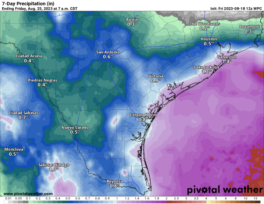
The good news? South Texas needs rain. The bad news? So does East Texas and Houston. So it appears this will help ease things a bit for Corpus and perhaps the Valley, with isolated 2 to 4 inch totals, depending on how well organized it is, exact track, etc. Eric has more over at our Houston-focused site, Space City Weather.
In terms of tropical development, this continues to look as if the speed will hinder it a bit. That being said, some modeling has shifted a bit toward this thing trying to make a last minute effort to organize. And it may be that this is what occurs. It blobs its way across the Gulf, and then in the 18 hours prior to arriving in Texas it makes a go at depression or tropical storm status. Interests along the Texas coast should continue to monitor the progress of this, just to be safe. We’ll keep you posted throughout the weekend on any forecast developments.
Invests 99L and 98L: Most likely for the fish
Both Invest 99L and Invest 98L are expected to probably remain out at sea over the next 4 or 5 days, with slow development possible from either or both area. The NHC has given 99L a 40 percent chance to develop and 98L a 70 percent chance. Invest 98L has the better chance to get a name, but Invest 99L is probably the more important of the two to watch, as it has a chance to at least graze the northeast Caribbean islands as it comes west. So should it organize, impacts would be possible in, say, the Virgin Islands or Puerto Rico. That is not the likely case however.
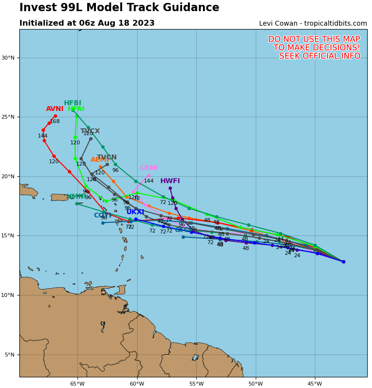
So interests in Puerto Rico and Virgin Islands should monitor 99L, but this doesn’t seem as if it will be a serious threat.
The medium range (days 6 to 10): The wild card wave
During the 6 to 10 day period, we’ll take Hilary and the Gulf wave off the board. Invest 98L and 99L, whatever they become should both be heading out to sea. That leaves us with the “wild card” area. Why am I calling it that? Because it has low odds of developing, but it is growing some model support. What is expected to happen is a piece of the monsoon trough, which Invest 99L is attempting to break from now may break off and sneak into the southern Caribbean. For the Windward Islands, this probably will just bring an increased chance of showers this weekend or early next week.
There are a couple options here. If it starts to organize, it will begin to feel the tug of a deep trough over the western Atlantic and get yanked north across the Greater Antilles and into the open waters, maybe grazing Bermuda on the way out. If it struggles, it may just sort of percolate in the southern Caribbean and/or dissipate.
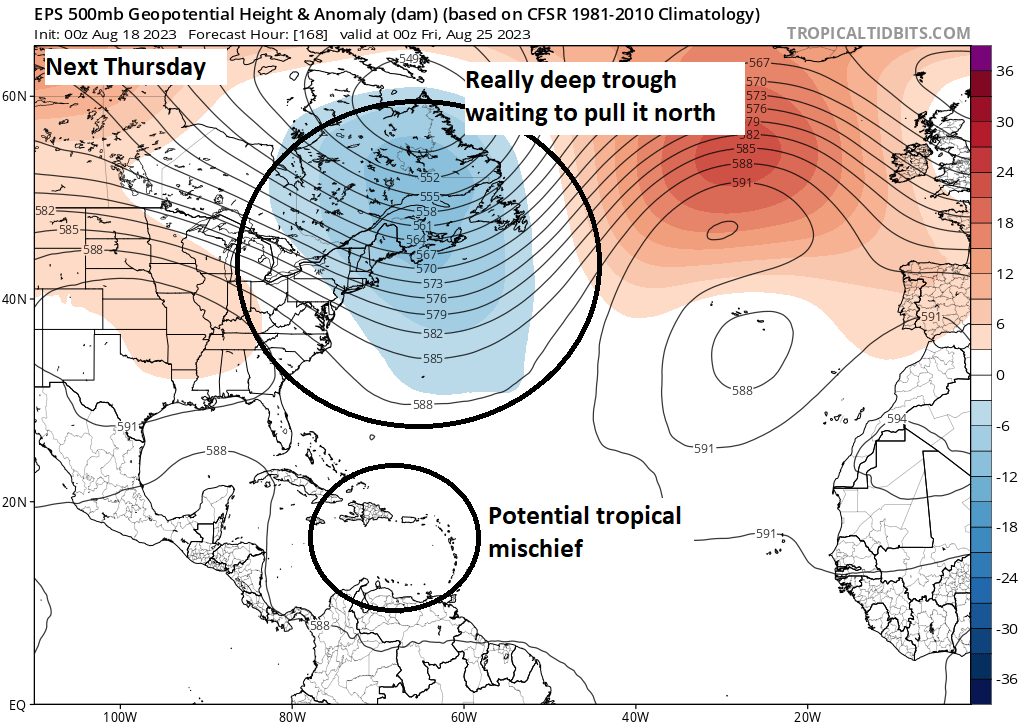
Either way, I wouldn’t expect serious impacts from this system, should it develop. For now. However, given the time of year, warm water, etc., you should continue to monitor the progress of this through next week.
Fantasyland (beyond day 10): The western Caribbean may gyrate
We’ll keep this brief a.) because this post is long enough and b.) we really can’t say with any confidence what will happen here. But, it continues to look as if a Central American gyre may develop and that will be worth watching. There is some chance for Gulf or Caribbean development in that pattern, but any details or specifics are impossible to pinpoint right now. But the final days of August will probably not be exceptionally quiet ones.
We’ll be with you all weekend, so if anything changes, you’ll know.
Thanks for the In-Depth Hurrican Forecasts! If it’s not on Space City Weather or The Eyewall I dont buy it!
I noticed that Hilary has a consistent “blob” ahead of it, which is reminiscent of anther major hurricane – Michael.
Absolutely love that y’all are also covering Hilary – my partner lives in Cali so this is helping us both a lot!
The satellite image map was/is a huge help in keeping all the information in perspective. Especially helpful for those of us who may not clearly recall our high school geography class. Thanks!
If you look at the radar loop above of Hilary there is a storm complex well NE of the eye. I believe these types of storms have a name. I seem to remember when we have strong hurricanes in the gulf the NE quadrant of the US gets hit with a nearly horizontal storm complex. I have searched for the name but cannot find anything. Help?
Predecessor rain event, or PREs. That can happen with these types of storm tracks, and I believe this will be part of the situation in the Southwest too.
That’s it. Thanks.
If anyone wants to get a little geeky here is a good paper on the phenomena:
http://schumacher.atmos.colostate.edu/research/galarneau_etal_2010_mwr.pdf