One-sentence summary
Morning forecast models continue to underscore the seriousness of the flooding threat facing the Southwest via Hurricane Hilary’s abundant rainfall.
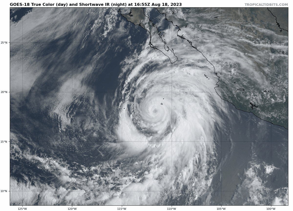
Happening now: Hilary holds as a major category 4 storm
Hurricane Hilary remains a powerful Category 4 storm. It has about 12 to 18 hours left before ocean conditions begin to cool, which should allow for Hilary to weaken somewhat as it comes north.
Hilary’s forecast track has not changed too terribly much so far today. In fact, one could argue that aside from a little nuance, Hilary’s future track is now mostly locked in and likely has little deviation expected.
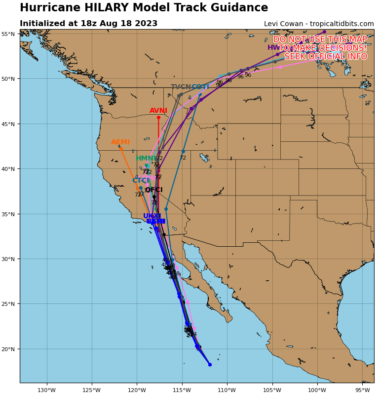
The message for folks in northern Baja, southern California, Nevada, and far western Arizona is pretty clear: While there may be a few details-oriented changes between now and Monday, the overall impacts you should expect will likely change very little. In other words, what you see (now) is what you (should) get.
The rain risk in the Southwest: It is very serious
I don’t want to bury the lede here. While there will be tropical impacts, including and especially to parts of Baja, the main and most severe impacts from Hilary will likely be in the form of flooding and extreme rainfall in the Desert Southwest. We don’t take these situations lightly, and if you’re new to our coverage, you might ask why we’re writing so aggressively about this. In the current media landscape, they’re valid questions, but in this case the answer is that this actually is that serious.
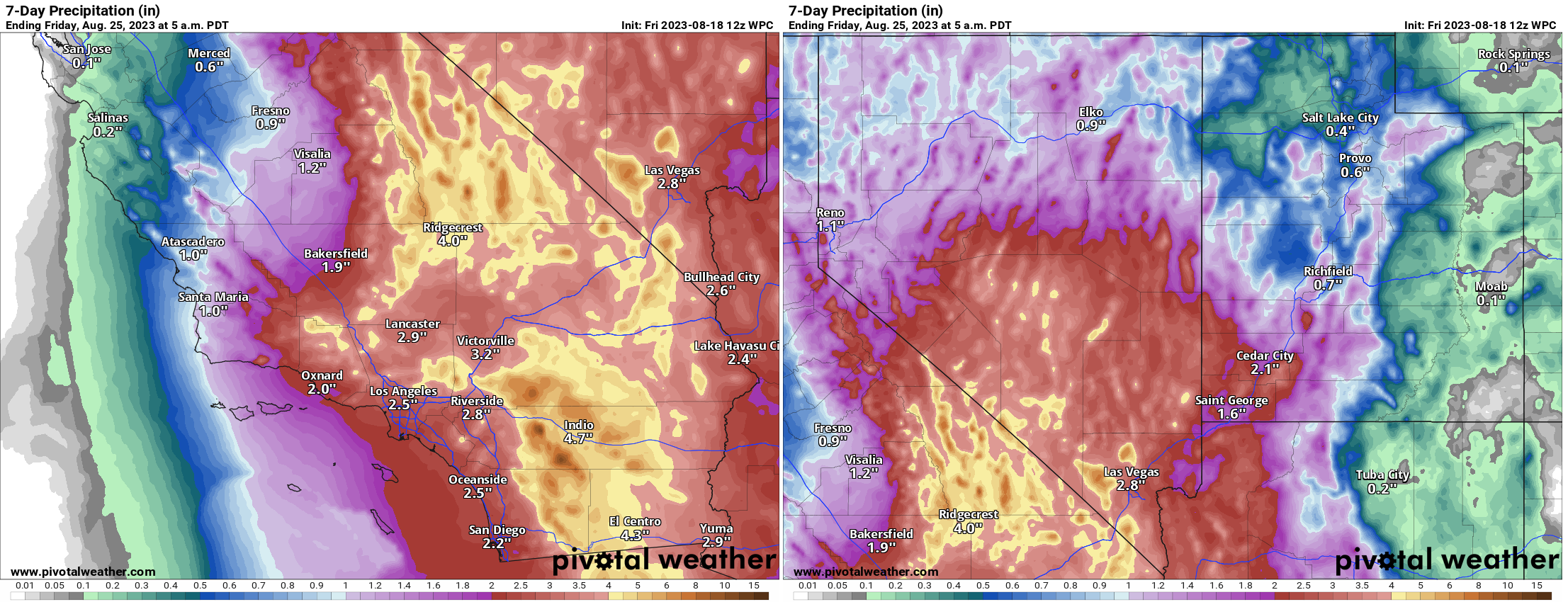
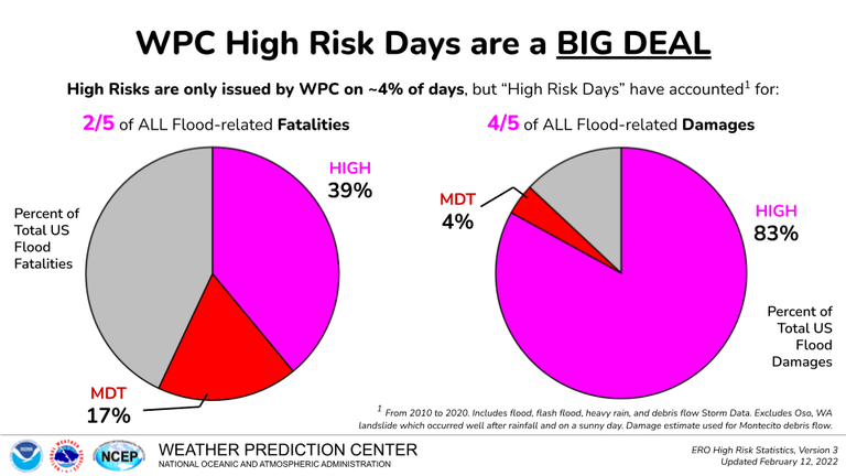
The current rainfall forecast for Indio, CA is about 4.7 inches. In a typical year, Indio expects just under 3 inches of rain. So, this is a place that already struggles to handle rain and has a chance to see more than its annual average rainfall over 2 days. This is exactly why the Weather Prediction Center issued their first high risk in this region for excessive rain on Sunday. As a Houston-based forecaster who has worked closely with the WPC and their rainfall products, I can assure you that issuing a day 3 high risk is not a decision they take lightly.
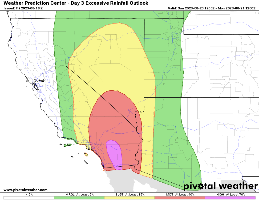
They issue high risks only when they are very confident that what they think will happen will happen. High risk rainfall days are associated with most of the flood damage that occurs in the United States.
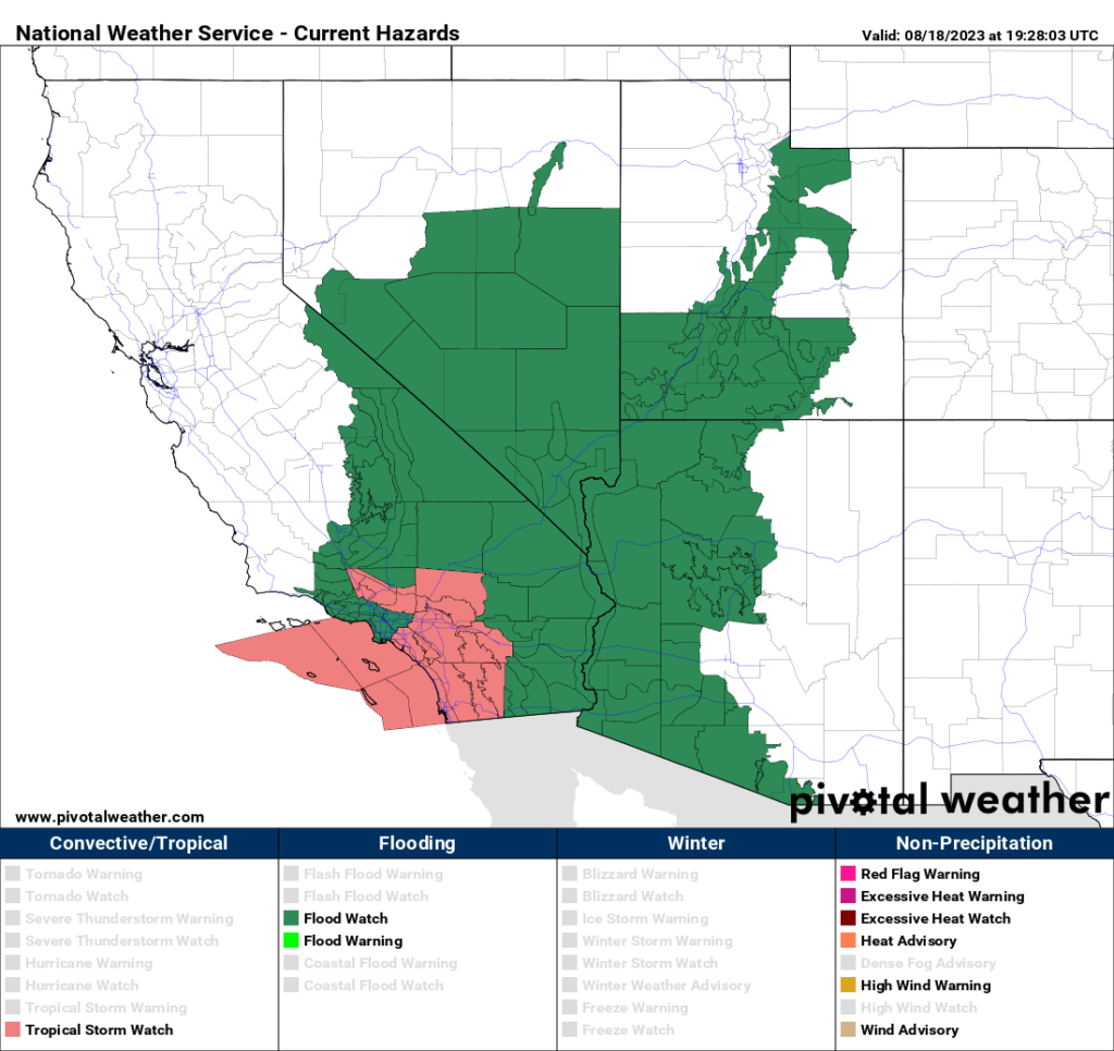
So I just want to be clear with folks that this is a big deal. If you live in the Coachella Valley or Palm Springs in particular, as well as “downstream” from any burn scars in SoCal, you need to be prepared for flooding Sunday or Monday. Travel between Vegas, Phoenix, or northern Arizona and LA may very well be disrupted in spots on I-15, I-40, or I-10 due to desert flooding. Same goes for I-8 between Yuma and San Diego. The area between Mexicali and Palm Springs is at highest risk, but there will be pockets of flooding elsewhere, including in the major metros on the coast (LA and San Diego), as well as in Yuma and Las Vegas. Please heed warnings from your local NWS offices. Now is a good time to get to know their websites and follow them on social media.
But the tropical storm part is cooler!
Some of you may be excited by the fact that a tropical storm is coming and big winds and big surf are on the way. And in fact, for the first time since they’ve been issued by the U.S. government, a tropical storm watch was posted today between the US/Mexico border and the Orange/LA County line, as well as Catalina Island. The hurricane warnings are confined between Punta Abreojos to Punta Eugenia in central Baja.
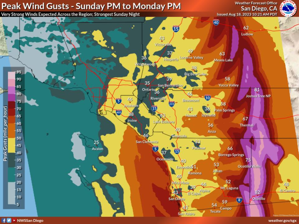
The max wind gusts expected aren’t terrible in the major cities of SoCal, with both Los Angeles and San Diego likely to see gusts as high as about 40 mph or so, perhaps a bit stronger on the coast of Orange County or in the North County portion of San Diego and just offshore. Gusts will likely pick up in the mountains and then be at their worst in portions of the desert over a narrow but long-ish region between Ocotillo and Joshua Tree up toward Baker on I-15.
Overall, Hilary remains on track to be a highly impactful, potentially historic event for the deserts of California and possibly Nevada. Please follow your local NWS office and heed any warnings if they’re given in your area. Be prepared to stay put for a day or two Sunday into Monday. We’ll have another update for you in the morning.
Will the trajectory into Canada rain or cause the wildfires up there to calm or flare up? Just curious if the rainfall might continue that long.
Good question, and the answer is kind of. The remnant “energy” from Hilary will actually go all the way north into Alberta and Saskatchewan I believe, and they are expecting a bit of a widespread rain up in Canada. Will it be enough to help? Hopefully a little. But you never can be sure. Still, some rain is better than none (up north at least), which is often an outcome in summer in the West.
I hope some moisture remains long enough to aid the dry conditions and fires there! Thanks for answering! And your coverage is so wonderful to an old time meteorological interested person. I take barometer readings from many port cities when there is something in the Gulf to try to determine where it will head. Your scientific analysis is so much better!
🌺 you guys sure do work hard to keep people informed – I’m sure I’m not the only one who can breathe easier after reading your posts 🌬 *whew*
Ty for never leaving us high & dry ☺️
⚘
About the fraction of flood-related damages that occur in events predicted to be high risk: 4/5 is 80%, but 83% is 5/6. Unless that 83 is rounded up from, say, 82.51, you should’ve considered using the larger fraction.
Thank you so much for the Hilary coverage! You are my go-to guys for Houston weather while my daughter is at Rice (and this past summer while she was doing an internship in VA) and I’m so glad to be able to rely on you now here in northern San Diego County! 👍
Any idea what these areas will look like Tuesday – Thursday? Is the flooding extreme enough it could be a 1-2 week shut down?
Honestly, do not know. It depends on who exactly gets hit hardest. It’s possible we have some issues in the desert that disrupt travel beyond a day or two. There will likely be some flooding damage to tend to as well in some communities. But the majority of the broader region should be back to normal midweek.
Do you expect disruption at LAX on Sunday?
I’d plan on delays at the least.
Why aren’t evacuations being recommended where the worst flooding is expected
If I would have to guess, combination of A) you can’t evac everyone in time anyway, and B) they dont know where it will flood. Unlike the gulf coast I’m sure there’s not nearly as much modeling and historical knowledge of what happens when you put this much rainfall on the desert.
No one should be camping right now, thats for sure.
My family and I are on vacation in San Diego right now and the feeling is that no one locally is that worried. As a native Houstonian who has been through many a hurricane and flooding event, my anxiety is a little high. I’ve been trying to find the equivalent to SCW here so imagine my surprise (or non-surprise for that matter) when I found your informative writing on the subject. Thank you for all that you do!
Glad we can help. In SD proper, I think it should be ok. It’s the interior where the real problems will be.