One-sentence summary
The forecast for Hilary is basically unchanged with a severe to historic rainstorm coming for the California deserts and parts of Nevada, while the odds of lower-end Gulf of Mexico development have nudged up a little and some welcome rain heads for South Texas.
Hurricane Hilary: Major flooding potential still likely in the California deserts
We’ll start with Hilary today. Hilary is beginning to feel the influence of cooler water and begin the transition from major hurricane to moderate hurricane and major rainstorm.
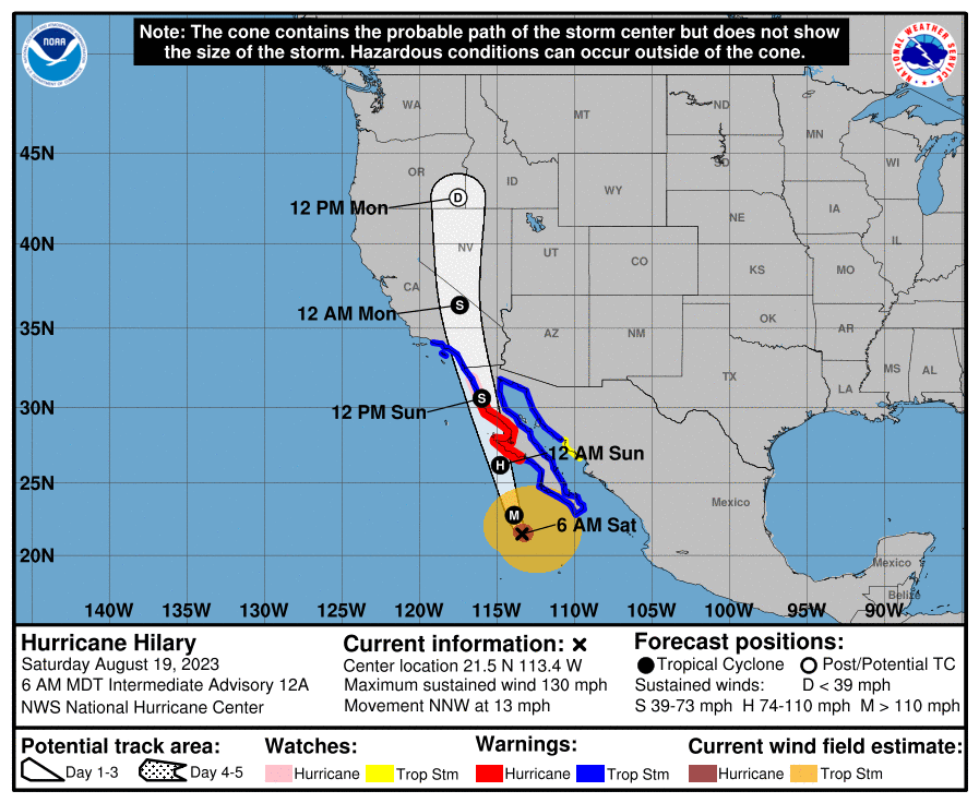
Hilary’s forecast track remains basically in line with the forecast since yesterday, coming north into SoCal as a tropical storm, a status which it may maintain all the way into Nevada. There are currently tropical storm warnings across most of Southern California, a first for them in modern history. Rain will actually start today as Hilary interacts with an abnormally strong trough off the California coast. This is an event we call a PRE, or predecessor rain event. I don’t want to oversaturate you with science, but you can read about what they are here. Suffice to say, this is not a common feature in California, Arizona, and Nevada.
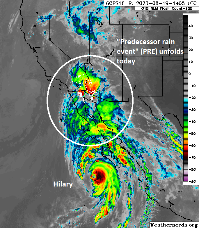
These types of rains can just help juice things up for the main event (tomorrow) from Hilary itself. Let’s talk things out by region to give you a sense of the impacts.
LA, Orange County, and San Diego
From what I’ve seen on social media, some people in Los Angeles think a hurricane is coming for them. While there will be impacts from Hilary in LA, the OC, and San Diego, the impacts will be worse inland in the deserts. Still, preparations for the summer equivalent of a big winter storm should probably be made, particularly along the immediate coast.
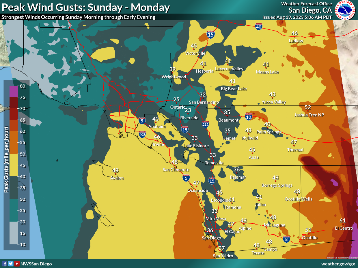
Wind gusts won’t be incredible, but they will probably push on tropical storm intensity along the coast and in the Channel Islands. Terrain in these areas means that wind will vary. With the storm going east of the mountains, winds will basically mimic a Santa Ana wind event, at least in terms of direction. So basically, areas that see the strongest winds in Santa Ana events in LA and San Diego will probably see the strongest winds with Hilary.
Rain totals in LA and San Diego will be 1 to 3 inches, enough to certainly cause some flooding, but the most serious impacts would be very limited in these areas I think to the immediate coastline and any burn scar areas, where heavy rain could lead to debris flows or mudslides. For the vast majority of metro SoCal, this will be a curiosity and inconvenient event, not a catastrophic one.
This also includes places like Riverside and San Bernardino, metro Inland Empire cities that are generally west of the north-south mountains.
Mojave Desert, Palm Springs, Imperial Valley, Death Valley
This is the area that those of us that are meteorologists are most concerned with in terms of extreme to catastrophic flooding impacts.
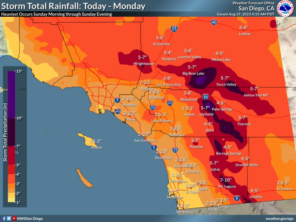
This is basically San Diego County east of the mountains, Imperial County, eastern Riverside and San Bernardino Counties, and Inyo County in California. Rain totals will equal 1 to 2 years of rainfall over 1 to 2 days for some of these areas. For those of you scoffing at 5 inches of rain leading to catastrophic flooding, remember that the deserts and areas with terrain are nowhere near as equipped as many places in the East to handle this type of rain and these type of rain rates. Land composition is much different in the West than the Central and East, and that means thresholds for severe outcomes are different.
Anyway, this is the region we are most concerned with. Travel between the coastal metros and places like Death Valley, Vegas, Kingman, Phoenix, and Yuma will almost certainly be disrupted for a time due to flooding and/or infrastructure damage. Damage in some parts of Joshua Tree National Park and Death Valley could be severe and extensive. As someone who has spent time in both parks, this saddens me a bit. Hopefully it’s not as bad as it could be, but these forecast totals are definitely troublesome. Please heed the warnings of your local National Weather Service offices (most likely San Diego, Phoenix, or Las Vegas) as this event unfolds.
Las Vegas and southern Nevada and Utah
Depending on exactly how the storm unfolds, impacts across Nevada may range from modest to severe. A high risk for flooding on Sunday is posted into Death Valley, but it does not include Las Vegas or southern Nevada at this time.
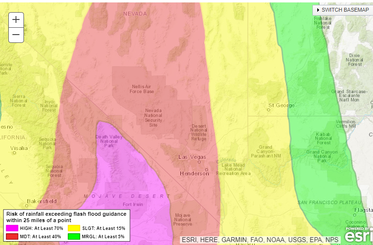
A moderate risk (level 3 of 4) is posted for most of Nevada tomorrow for excessive rainfall. We expect some degree of flooding here, particular in isolated spots and in favored mountain locations. Total rainfall in Las Vegas is expected to be on the order of 1 to 3 inches, an amount that will surely cause some flooding issues, but hopefully not the severe issues we’ll see in the California deserts.
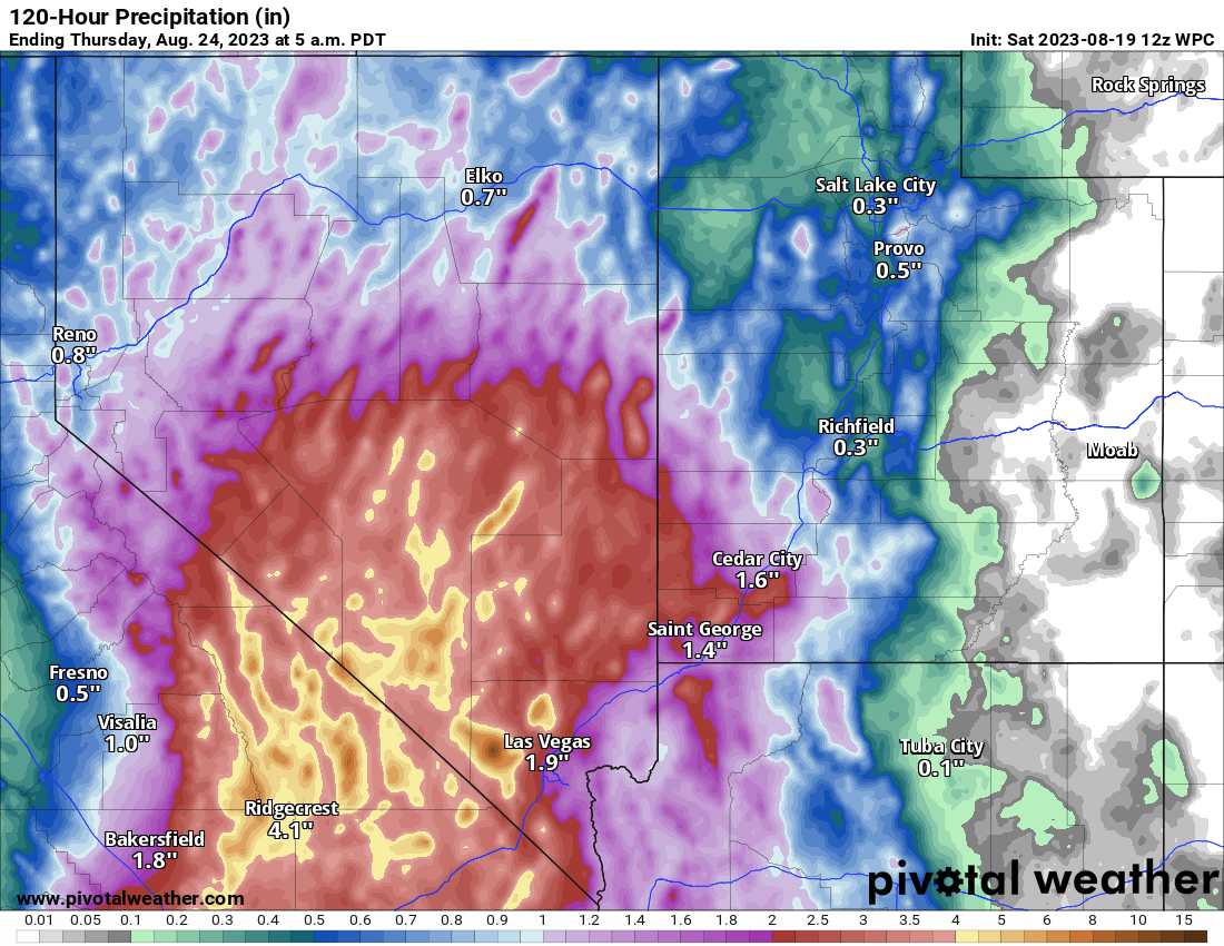
Even up into southwest Utah, rain totals of an inch or two are possible for places like St. George and even not far from Zion National Park. Flood watches are posted for all of Nevada except Reno/Tahoe and north. Much of Utah is also under a flood watch.
Flood watches extend north of Nevada into southwest Idaho and southeast Oregon as well, where remnant rain will produce localized flooding.
Arizona
Heavy rain and pockets of flash flooding are likely in western Arizona as well from Hilary.
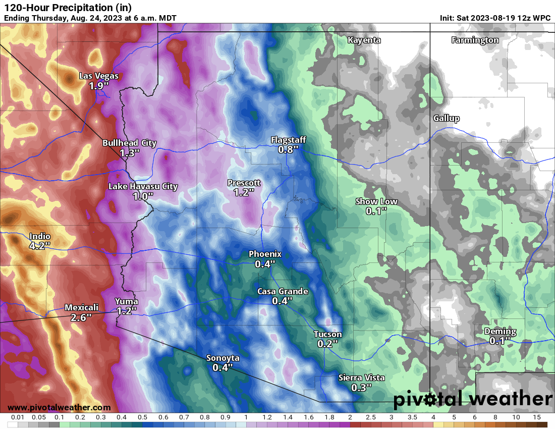
Flood watches are posted for all of western Arizona, including Prescott, Yuma, and Kingman. Rain totals of 1 to 3 inches are likely here with lesser amounts in eastern Arizona. Flooding is not currently expected to be an issue in Phoenix.
The bottom line: Hilary will bring varying impacts across the southwest, but the most concerning ones will occur in the deserts of California where we are very concerned about flooding. Please be ready for a rough Sunday and/or Monday in those areas.
Gulf of Mexico development chances inching up
The National Hurricane Center has upgraded the potential for the Gulf system to attain tropical depression or tropical storm status early next week to 50 percent.
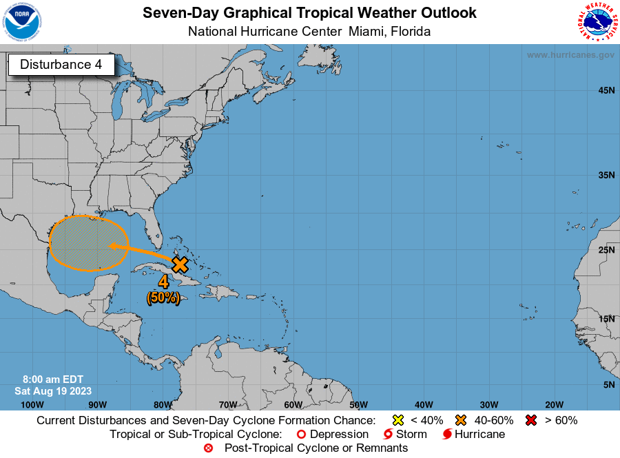
Looking on satellite this morning, the disturbance aiming to come into the Gulf is showing some spicy thunderstorm activity, but it lacks any real organization still at this point.
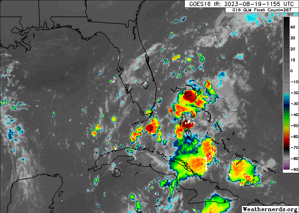
This currently is just a few blobs of heavier thunderstorms moving into the Gulf. As this comes west, it will probably encounter a little bit of a less hostile environment and may begin to slowly organize. But it’s going to be hauling west and will have less than 48 hours over the Gulf meaning even if does organize, it will likely come ashore in South Texas as depression or low-end tropical storm, at worst.
The main impact from this, besides some modest marine impacts, will be rainfall, much needed rainfall at that. However not all of Texas gets to play.
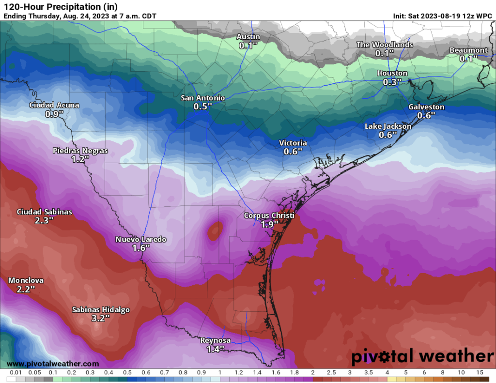
In fact, much of the Houston area may see little to no rain from this system. Perhaps a bit south of I-10 or near the coast. Corpus Christi? Brownsville? Laredo? Perhaps 1 to 3 inches of extremely beneficial rain. That will extend into Mexico, which also could use some rainfall. But drought conditions that have taken hold in much of East Texas are going to remain or worsen. As we head into early September, the persistent ridge that has been bringing day after day after day of high heat to Texas may begin to weaken some, but it does not want to let go just yet. Sadly, there is no well-defined “next best” chance of rain for drought-plagued parts of Texas after this.
Elsewhere: Multiple Atlantic waves
A quick look at the NHC fruit basket shows three Atlantic disturbances, from left to right Invests 90L, 99L, and 98L.
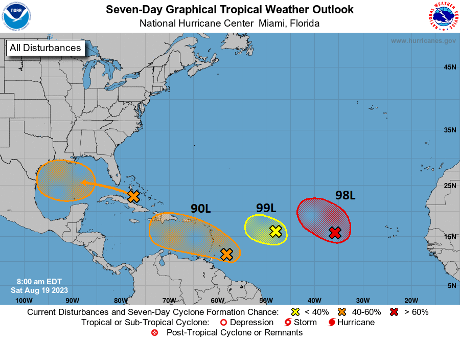
Of the three, Invest 98L still has the best chance of forming into something, though it will remain out over the open Atlantic. Invest 99L is a nothingburger. Invest 90L may draw in most people’s eyeballs. We’ll keep an eye on this one, but at this point development looks sluggish and lower-end. Just wanted to make sure you knew we weren’t ignoring the rest of the Atlantic!
How does a high ridge just park itself over Texas since June and doesn’t move the entire summer? Is this normal?
It is now. Get used to it.
Why?
I mean, I get that global average temperatures are higher, but why does that lead to such extreme heat/ridge conditions in this specific part of the globe? What’s happening in Texas is a much larger departure from normal than the global temperature increase (especially since the NWS normals are based on the last 30 years, so all the global warming that happened before 1990 is already baked-in).
IE how does an increase of X globally “amplify” into like a 10X-20X increase specifically in Texas summers?
It’s actually moved a lot this summer! The problem is that it’s been so strong and basically just moving east to west between the Four Corners and the Southeast and occasionally to the north that Texas just keeps getting put under its influence. I actually can’t recall a summer in recent years with so much variability in ridge placement…but every. single. time. it seems to get us. Pretty remarkable.
Hmm, so is the fact that Texas keeps getting caught under it (in any of those positions) more a result of luck than climate change?
(Even if the strength of the ridge is climate change affected, and/or its starting from a warmer baseline…)
Please keep the science coming (though in slightly less opaque language than your PRE link!). Like a lot of scientific papers, the abstract and first few pages is enough to get the general idea, which is all I wanted.
Copy that! We try not to overly science things for people — but we try to provide them access to learn more if they desire.
Thanks for the weekend update guys!
awesome info ☺️
tysm ⚘⚘⚘
You guys got us through every storm in Houston when we lived there (2016-2022), and I’ve missed you since we moved to SoCal. IM SO PSYCHED ABOUT THIS NEW SITE. Thank youuuuuuuuu 🙏🏽🙏🏽
Hopefully this is the only time you need us! 🙂
How will Hilary bode for Lake Mead?
A lot of people have asked this, and my hunch is that it will help it. A little. The majority of the rain is likely to fall downstream of Mead. But there will be a decent amount over Mead proper and upstream, so it should give it a nice summertime boost, but this will not send it back to “early days” levels or anything. I would assume this helps offset some of the normal summertime draw down though, so there’s nothing bad about that.
Was thinking this myself last night, perhaps sufficient rainfall to bring up some water level to Lake Mead. Time will tell.
Why is 99L a nothingburger? It’s now 70% odds of development. Does that mean even if it develops it will fall apart before reaching any land? Or just that it will be weak?
Looking at the map they posted, 99L is the yellow x with less than 40% chance. 98L is the red x with a >70% chance and they said that one would likely stay out in the Atlantic. Misread?
Seems a bit odd as it’s now fully a tropical depression (text still says 70%, but the graphic is updated), but seems like NOAA doesn’t think it will jump above tropical depression level
Correct. It was revised this afternoon and 99L did just enough to get over the hump. Thankfully it will be short-lived and shouldn’t impact land.
The latter. It’s not expected to impact land or become more than a depression. Admittedly, it was a little surprising to see it become one this evening, but that doesn’t change the thinking much.
That makes sense, thanks for explaining!
The Death Ridge strikes again.
2011 is a contender to take the title of most miserable summer away, even though statistically speaking, 2011 was still worse.
Houston has a rain allergy.
Typo. 2023
How long did the ridge last in 2011 (when in fall did it go away, and was it a dramatic end or a slow decline)? I went away to college at the end of summer that year so I wasn’t around for the end of it.
Y’all are great!! I love reading your posts and info on storm coverage and what to expect.
Keep up the great work!!
Thank you!